Location: Itatiaia, Rio de Janeiro Map
Interesting facts: Itatiaia means "many pointed rock" in Tupi.
Itatiaia National Park is a protected biosphere located on the border of Rio de Janeiro and Minas Gerais states in Brazil. Itatiaia National Park is famous for Dr. Josef Mengele, Angel of Death, a Nazi SS officer and Auschwitz physician who hid here after escape from post- war Europe. Inside the park are some of the highest peaks in Brazil, bordering the 2 800 m altitude. The fauna and flora of the park are quite diverse, mainly due to the altitude difference of its relief and the varied climate. Itatiaia is currently administered by the Chico Mendes Institute for Biodiversity Conservation (ICMBio). The BR-485, which runs through the park, has its highest point at 2,460 m inland and is thus considered the highest road in Brazil.
The area belonged to the Viscount of Mauá and was acquired by the
Federal Treasury in 1908, for the creation of two colonial nuclei
for fruit cultivation.
It was in 1913 that botanist Alberto
Loefgren asked the Ministry of Agriculture to create a national park
in the Itatiaia massif. In the same year the idea of a national
park was supported by geologists, botanists and geographers at a
conference held at the Rio de Janeiro Geography Society. The
national heritage lands of Brazil in the Itatiaia region were
incorporated in 1914 into the heritage of the Botanical Garden,
where the Itatiaia Biological Station was maintained, in an area of
119,439,432 m² (11,943 ha).
Itatiaia National Park was
created by Decree No. 1,713, issued on June 14, 1937 by Getúlio
Vargas, from Itatiaia Biological Station. The creation decree
provided for the transfer of the existing improvements at the time,
belonging to the Biological Station, to the newly created national
park. The vacant lands in the vicinity of the park, under the domain
of the Union, were reserved by the same decree for the installation
of hotels and infrastructure necessary for the movement of tourists
in the region. The same decree also mentioned the incorporation into
the park of small plots belonging to private individuals, at the
time jammed in lands under the domain of the Union. Presidency of
the Republic.
Geography
It lies geographically between the
parallels 22º19 'and 22º45' south latitude and the meridians 44º15
'and 44º50' west longitude. The park is located in the Itatiaia
massif, in the Mantiqueira mountain range, in the southern states of
Rio de Janeiro and Minas Gerais, with territory covering the
municipalities of Alagoa, Bocaina de Minas, Itamonte, Itatiaia and
Resende. The territory of the park is cut by the BR-485. Because it
crosses regions of up to 2,350 m, it is considered the highest road
in Brazil. The park is divided into two distinct environments:
Park Headquarters (Lower Part): Leaving Rio de Janeiro or São
Paulo, follow the Presidente Dutra Highway (BR 116) to the city of
Itatiaia, km 316 height. The Visitor Center, located in the lower
part of the park It has a museum with basic information about the
fauna and flora of the region, with stuffed animals and a library.
Plateau (Upper part): Leaving Rio de Janeiro or São Paulo, follow
the Presidente Dutra Highway (BR-116) to Engenheiro Passos, height
of kilometer 330, following the BR-354 highway towards Itamonte.
Geology
Itatiaia is in an alkaline complex formed by
syenites, foiaitos, pulaskitos, quartz-syenites, loopholes and
alkaline granite. Rock formations are considered rare, rarely found
in the rest of the country, similar to granite, but in the case of
syenite nepheline. There are also rocks of eruptive origin.
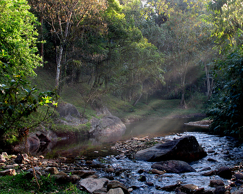
Hydrography
In the park, several rivers forming the Paraíba do
Sul and Rio Grande river basins are born. The hydrographic network
is formed by rivers of crystalline waters, which form natural pools
and waterfalls. Its main rivers are: Campo Belo, Maromba, Flores,
Marimbondo, Black and Aiuruoca. On the plateau (upper part) there
are several lakes, such as Lagoa Bonita or Lagoa Dourada, among
others smaller, which may have their surface frozen during harsh
winters.
Fauna and Flora
On the slope facing the Paraíba
Valley, predominates the Atlantic forest with rich and lush fauna
and flora, herbaceous and has the highest rate of endemism, ie it is
composed of species that only occur there, such as bromeliads and
orchids among others. It is one of only four locations where an
endangered tree, the Buchenavia hoehneana, can be found.
The
fauna of the lower part is richer, providing more shelter for
mammals, such as paca, coati and some larger species such as puma,
guinea pigs and jaws. With great diversity of birds, such as the
hummingbird (hummingbird, purple hummingbird among others), as well
as green-billed toucans and guachos. The importance of Itatiaia for
the conservation of bird species is great given the large frugivores
and the highlanders.
Climate
According to the Köppen-Geiger climate classification,
the park is influenced by three types of climate: Csb (wet temperate
climate with dry and temperate summer), Cwb (wet temperate climate
with dry winter and temperate summer) and Cwa (humid temperate
climate) with dry winter and hot summer).
During the
Brazilian winter, in July and August, the temperature decreases too
much and the rainfall also, leaving the weather dry and very cold.
Consequently, in a country with 92% of its area located in the
tropical zone, phenomena such as frost on the fields and plants of
the park can occur, as well as snowfall on the harsher days.
In the first half of the twentieth century, INMET (National
Institute of Meteorology) had a weather station within the park,
proving the region's cold weather. As of June 2013, a new
state-of-the-art automatic weather station was installed at an
altitude of 2451 meters by the Brazil Below Zero forum. In the
following years, 2 more stations were installed: Furnas (2470m) and
more recently, Campo Belo (2438m), which has been recording the
lowest lows in Brazil. There is a third private station, borrowed by
Artur Chiovitti, at the top of Morena do Massena (2584m), which is
the highest weather station in Brazil. In August 2016, Campo Belo
reported a minimum of -13.3 ° C, being the second lowest temperature
ever recorded in Brazil.