Pantanal Conservation Area is World's largest
wetland situated in Mato Grosso do Sul state in Brazil. It covers an
area of 195,00 km2 (75,000 mi2). It is located in southern Mato
Grosso and northwest of Mato Grosso do Sul, both states of Brazil,
as well as parts of northern Paraguay and eastern Bolivia (where it
is called the Bolivian chaco). The Pantanal is considered the
largest continuous floodplain in the world, with 140,000 km² in
Brazilian territory.
The region considered by UNESCO as a
World Natural Heritage and Biosphere Reserve, located in the
Pantanal National Park region. Despite the name, there are a small
number of marshy areas in the marshland. In addition, as it is flat
ground, it facilitates flooding.
The origin of the Pantanal is not, as it was
thought, a result of the separation of the ocean millions of years
ago. All geologists agree that there is no evidence of the presence
of the sea there, and one of those who best know the region,
Fernando Flavio Marques de Almeida, says that it represents an area
that was hit by block failures during the Tertiary period. Animals
that are present in the sea also exist in the wetland, forming what
may be called the inland sea. The wetland area of the wetland is
due to the slow drainage of slowly flowing waters through the region
of middle Paraguay, in a place called the Closure of Morros do Sul.
Attracted by the existence of precious stones and metals (which were
used by indigenous people, who were already populated the region as
adornments), among them the gold, the Portuguese Aleixo Garcia, in
1524, ended up being the first to visit the territory, and reached
the Paraguay River through the Miranda River, reaching the region
where today is the city of Corumbá . In the years 1537 and 1538, the
Spanish Juan Ayolas and his companion Domingos Martínez de Irala
followed the Paraguay River and named Puerto de los Reyes to the
Gayva lagoon. Around 1542-1543, Alvaro Nunes Cabeza de Vaca (Spanish
and adventurer) also passed by the place to go to Peru.
Between 1878 and 1930, the city of Corumbá became the main
commercial and river axis in Mato Grosso (before the state division,
which took place in 1977). Later it lost its importance for the
cities of Cuiabá and Campo Grande, thus beginning a period of
economic decay.
The incentive given by governments from the
1960s to develop the Midwest region, where Mato Grosso is located,
through the implementation of agricultural projects, brought many
changes in the cerrado environments, threatening its biodiversity.
Concerned with the conservation of the Pantanal, Embrapa set up a
research unit in Corumbá in 1975 to adapt, develop and transfer
technologies for the sustainable use of its natural resources.
Since 2000 there have been massive investments in the ecotourism
sector, with several Pantanal lodges practicing this sustainable
tourism modality. And along with these increased the area of
livestock and agriculture.
Geography
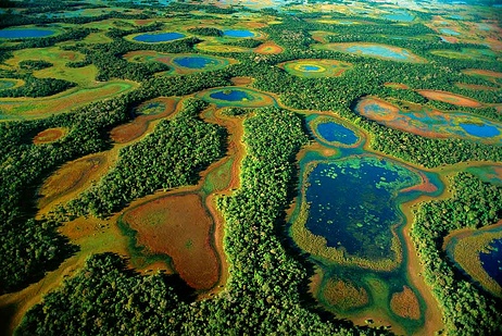
The Pantanal is one
of the largest continuous wetlands on the planet and is located in
central South America, in the Upper Paraguay watershed. Its area is
150,000 km², with 65% of its territory in the state of Mato Grosso
do Sul and 35% in Mato Grosso. The region is divided into two
subdivisions: Upper Pantanal Microregion (in Mato Grosso) and Lower
Pantanal Microregion and Aquidauana Microregion (in Mato Grosso do
Sul).
From the point of view of physiography and
geomorphology, the Pantanal is defined as a "large and relatively
complex plain of detrital-alluvial coalescence". Silva & Abdon
(1998), using flood and relief criteria, divide the area into eleven
subregions (Cáceres, Poconé, Barão de Melgaço, Paraguay, Paiaguás,
Nhecolândia, Abobral, Aquidauana, Miranda, Nabileque, Porto
Murtinho) .
Hydrography
The Paraguay River passes through
the city of Caceres, Mato Grosso, where it is known as the "Little
Princess of the Paraguay River" and its tributaries run through the
Pantanal, forming extensive flooded areas that shelter many fish,
such as the painted, the golden, the pacu. , and also for other
animals, such as alligators, capybaras and otters, among other
species. Many endangered animals in other parts of Brazil still have
vigorous populations in the Pantanal region, such as the marsh deer,
the capybara, the tuíiú and the alligator.
Due to the low
slope of this plain north-south and east-west, the water that falls
in the headwaters of the Paraguay River can spend four months or
more to cross the entire Pantanal. Ecosystems are characterized by
scrubland and scrubland without periodic flooding, flooded fields
and aquatic environments such as freshwater or brackish ponds,
rivers, ebb and flow.
Climate
The climate in the Pantanal is hot and
humid in summer, and although it is relatively colder in winter, it
still has high air humidity due to evapotranspiration associated
with water accumulated in the soil at the root horizon during the
flood period. Most of the Pantanal's soils are sandy and support
native pastures used by native herbivores and cattle introduced by
the region's settlers. A small portion of the original pasture has
been replaced by exotic forages such as Brachiaria (4.5% in 2006).
The surface energy balance (ie, the energy exchange between the
surface and the atmosphere) is greatly influenced by the presence of
water slides, which partially cover the ground each summer, and the
particular characteristics of the water and energy balances end up.
influence the development of the regional Atmospheric Limit Layer.
Topography
The Pantanal Plain has approximately 230 thousand
km², a measure estimated by scholars who explain that it is
difficult to establish an exact calculation of its dimensions, since
in several points where the Pantanal begins is in Cáceres and
Poconé, Mato Grosso and where the Pantanal ends. It is difficult to
know why it is very extensive and the surrounding regions, and with
each closing cycle of dry and water seasons the Pantanal changes.
Its area in Brazil is 124,457.145.22 km² (64.64% in Mato Grosso do
Sul and 35.36% in Mato Grosso). Considered one of the largest
sedimentation plains on the planet, the Pantanal extends through
Bolivia and Paraguay, countries where it receives other names, being
Chaco the best known.
The plain is slightly undulating,
dotted by rare isolated elevations, often called hills and hills,
and rich in shallow depressions. Its boundaries are marked by varied
elevation systems such as plateaus, mountains and massifs, and is
cut by a large number of rivers of all sizes, all belonging to the
Paraguay River Basin - the main ones being the Cuiabá, Piquiri, São
Lourenço, Taquari rivers. , Aquidauana, Miranda, Paraguay River and
Apa. The Pantanal is surrounded, on the Brazilian side (north, east
and southeast) by lands with altitude between 600 and 700 meters; It
extends west to the foothills of the Andes and extends south across
the central Pampean plains.
Rainfall
The Pantanal lives
under the design of the waters: there, rain divides life into two
very distinct periods. During the drought months - from May to
September - approximately - the landscape undergoes radical changes:
as the waters recede, fields, sandbanks, islands are discovered and
rivers resume their natural beds, but not always following the
course of the period. previous. The waters run down the depressions
of the terrain, forming the crows (channels that connect the waters
of bays, lagoons, wetlands etc. with the nearby rivers).
In
large fields covered predominantly by grass and savannah vegetation,
surface water is scarce, restricted to perennial, defined-bed
rivers, to large lakes near these rivers, called bays, and to some
smaller, wetted lagoons. in lower areas of the plain. In many
places, groundwater, groundwater or aquifers need to be used, using
hand pumps and / or touched by windmills to ensure the supply to
homes and drinking fountains of domestic animals.
The first
rains of the season fall on dry, porous soil and are easily
absorbed. From October to April rains fall torrentially on the
headwaters of the Paraguay Basin rivers to the north. With the
constant moistening of the land, the plain quickly turns green due
to the sprouting of countless water-resistant species from previous
months. This large periodic increase of the Pantanal water network,
the low slope of the plain and the difficulty of water flow through
the flooding, are responsible for flooding in the lower areas,
forming bays of hundreds of square kilometers, which gives the
region a aspect of immense inland sea.
The downpour raises
the level of permanent bays, creates new ones, overflows the rivers
and floods the surrounding fields, and isolated hills stand out as
veritable vegetation-clad islands - clusters of these islands are
called swamp mountain ranges - in the islands and mountain ranges
the animals come together. they seek refuge from rising waters.
At this time it is difficult to travel through the
Pantanal because many roads are flooded and impassable. People,
animals and goods can only be transported on the back of pack
animals and boats - many farms and settlements (also known as
guardrails) located in low-lying areas are isolated from supply
centers, and access to them, many Sometimes it can only be done by
boat or plane.
With rising waters, large amounts of organic
matter are carried by the current and transported over considerable
distances. Represented mainly by masses of floating and marginal
vegetation and animals killed in the flood, these remains, during
the ebb, are deposited on the banks and beaches of rivers, lakes and
wetlands and, after rapid decomposition, become the fertilizer
element of the river. soil, capable of guaranteeing the enormous
diversity of plant types there.
Among the varied vegetation
are numerous species of animals, adapted to this region of such
contradictory aspects. This immense variety of life, translated into
constant movement of shapes, colors and sounds is one of the most
beautiful spectacles on earth. Because of this alternation between
dry and wet periods, the Pantanal landscape is never the same,
changing every year: riverbeds change their paths; the large bays
alter their designs.