Location: Mato Grosso do Sul Map
Area: 76,400 ha
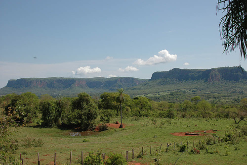
The plateaus and mountains of Bodoquena, is a morphological zone in
southwestern Brazil, about 240 km from Ponta Porá in Paraguay. It is
located in the southwest of the Pantanal of Mato Grosso. The plateau
and its flora and fauna are protected by one of the main
conservation units of the State of Mato Grosso, the Serra da
Bodoquena National Park.
The elongated plateau is formed by
calcareous rocks and dolomites, its maximum width is 40 km between
the towns of Bonito and Santa Eugênia. Throughout its extension,
narrow valleys and deep canyons cut to the bottom are observed as a
result of the geological characteristics of the geographical
feature. The plateau contains important mineral reserves due to the
carboniferous rocks that make it up.
The western slope of
Bodoquena is characterized by its abrupt cuts, which are found to
the north of the headwaters of the Aquidabã River. There the
mountain range has its highest elevation, which exceeds 700 meters.
In this area some streams and rivers have their slopes that later
end up flowing into the Paraguay River. For its part, on the eastern
slope, the plateau defines its side in vertical dolomite mountains,
which in steps converge with the surrounding plain. In its southern
area, the plateau is not so steep, and its elevation barely reaches
300 meters.
Due to the type of calcareous terrain, the bowels
of the plateau present erosion processes due to the action of
underground rivers and the runoff of water from the surface, giving
rise to the existence of calcareous caves and small lagoons fed by
the abundant rainfall that are observed in the region.
The park is classified as IUCN Protection Area II (national park).
Its objective is to preserve natural ecosystems of great ecological
relevance and scenic beauty, enabling scientific research,
environmental education, outdoor recreation and ecotourism.
Protected species include the black catfish (Ancistrus formoso), the
jaguar (Panthera onca) and the puma (Puma concolor).
Geography
The park belongs to the cerrado biome. It covers an
area of 77,022 hectares, was created on September 21, 2000 and is
managed by the Chico Mendes Institute for Biodiversity Conservation.
The park is in the Pantanal Biosphere Reserve, which also includes
the Pantanal, Chapada dos Guimarães and Emas national parks, in
addition to the state parks of Serra de Santa Bárbara, Nascentes do
Rio Taquari and Pantanal do Rio Negro. It covers parts of the
municipalities of Porto Murtinho, Jardim, Bonito and Bodoquena, in
Mato Grosso do Sul.
Geology
Modern and ancient limestone
tufas, the latter located in abandoned drainage channels, present
excellent leaf molds, which, together with carbon and oxygen isotope
studies, allow paleoclimatic and paleohydrological interpretations.
In addition to this scientific interest, the limestone tufas form
landscape sets of unusual beauty, much sought after by tourists,
reasons that imply the need to preserve these deposits and special
attention to the quality of the waters of their rivers, on which the
continuity of the process of formation of these deposits
Hydrography
The rivers in the region are known for their very
crystalline and bicarbonated waters, with a brackish taste. Such
transparency is due to the following factors: the exit of the spring
with very little turbidity, not acquiring clay in its movement, in
the springs very pure limestone rocks avoid the presence of clay.
This limestone present in the rivers that comes from such rocks
present in the springs acts as a filter, depositing impurities at
the bottom, where rocks are in permanent dissolution and through
fractures in the soil form caves, abysses and underground conduits.
Flora
In addition to the cerrado, typical vegetation of
Central Brazil, it is found on the tops of hills, calcareous soils
and rocky outcrops where the Seasonal Deciduous Forest occurs, where
plants lose all their leaves in the dry season. In other
environments, the Semideciduous Seasonal Forest is present, which
loses only part of the leaves in the same period. The riparian
forests present on the banks of rivers and water courses, lose few
leaves, allowing the humidity to be high throughout the forest. In
addition, the riparian forest plays the role of a great protector of
the crystalline waters of the rivers, protecting the soil from the
rains. strong and preventing the river from being silted up by
mounds of earth carried by them.
Fauna
The fauna on the
Bodoquena Plateau is interesting for its habits. In the dry season,
their agitation is a sign that their young can be born in the spring
and they grow up when the food supply is greater. There is a very
harmonious symbiosis between the species of Serra da Bodoquena.
Birds and capybaras are an example, after all, fleas become food for
birds and capybaras get clean. The same occurs with the
yellow-snouted caiman, common in the region, and the butterflies. To
date, more than 340 species of birds, 195 of mammals and 50 of fish
are known.
Climate
The tropical climate, with an average
temperature ranging from 25 to 30°C in the summer from 15 to 20°C in
the winter, reaching 0 to 40°C. . Average rainfall varies from 1200
to 1500 mm annually and the dry period lasts 3 to 4 months with
brief droughts from May to August. In the Planalto da Bodoquena,
located on the southeastern edge of the Pantanal complex, in the
state of Mato Grosso do Sul, numerous deposits of calcareous tufa
are under development along the current drainage in the form of
waterfalls and natural dams. The turbidity of the waters of the
rivers is practically nil, and this is due to the fact that their
headwaters, which cut through the plateau and flow into the left
bank of the Miranda River, are located in areas of very pure
limestone exposure.