Location: Santa Catarina Map
Area: 57374 ha
Tel. 55 (47) 3326-1527/ 3329-5887
Email: parnaserradoitajai@icmbio.gov.br
Serra do Itajaí National Park (Parque Nacional da Serra do Itajaí), also known as Itajaí Mountains National Park, is a vital conservation unit in southern Brazil, dedicated to protecting a significant remnant of the Atlantic Forest biome. Established in 2004, the park spans 57,375 hectares (approximately 141,780 acres) and serves as a refuge for endangered species, while promoting scientific research, environmental education, eco-tourism, and outdoor recreation. It is one of the largest remaining forest fragments in Santa Catarina state, highlighting the region's mega-diverse ecosystems amid ongoing threats like deforestation and poaching. Administered by the Chico Mendes Institute for Biodiversity Conservation (ICMBio), the park exemplifies Brazil's commitment to preserving the Atlantic Forest, a global biodiversity hotspot with high endemism and ecological importance.
The park is located in the state of Santa Catarina, in southern Brazil, within the Itajaí Valley region. It encompasses portions of nine municipalities: Ascurra, Apiúna, Blumenau, Botuverá, Gaspar, Guabiruba, Indaial, Presidente Nereu, and Vidal Ramos. The nearest major city is Brusque, with Blumenau also serving as a key access point. Geographic coordinates center around 27°07′30″S 49°11′42″W, placing it in a mountainous area between the Serra do Tabuleiro State Park to the south and Serra da Dona Francisca to the north. The park is accessible via regional roads, with entrances near communities like Faxinal do Bepe. Its subtropical climate features high rainfall (around 1,500-2,000 mm annually), temperatures averaging 18-22°C, and humid conditions, influencing its lush vegetation and seasonal visitor patterns.
Serra do Itajaí National Park was officially created by Federal Decree on June 4, 2004, with boundary modifications enacted on February 20, 2006. This establishment aimed to safeguard a critical area of the Atlantic Forest from escalating threats like agricultural expansion and illegal logging. The park's creation was part of Brazil's broader efforts to expand protected areas in the early 2000s, aligning with the National System of Conservation Units (SNUC). Since its inception, it has been managed by ICMBio, with ongoing initiatives including volunteer programs launched in 2019-2020 and research collaborations. Historical human presence in the region includes indigenous communities and later European settlers, but the park's focus remains on ecological preservation rather than cultural heritage sites.
The park's geography is characterized by rugged mountainous terrain within the Serra do Itajaí range, part of the larger Serra do Mar system, with elevations ranging from 200 to over 1,000 meters. This creates diverse microhabitats, including steep slopes, valleys, and river basins drained by the Itajaí-Açu River and its tributaries. Geologically, the area features ancient Precambrian rocks, primarily granites and gneisses, overlaid with sedimentary deposits from erosion processes over millions of years. The landscape is shaped by tectonic activity and heavy rainfall, leading to deep canyons, waterfalls, and fertile soils supporting dense forests. The park acts as a watershed protector, contributing to regional hydrology, but faces geological risks like landslides during intense rains.
Serra do Itajaí is a biodiversity hotspot in the Atlantic Forest, hosting high levels of endemism and threatened species. Flora includes over 643 herbaceous and shrub species, with dominant trees like Araucaria angustifolia in mixed forests, alongside palms, ferns, and epiphytes. Fauna comprises 11 carnivore species (40% threatened), including the cougar (Puma concolor), margay (Leopardus wiedii), and ocelot. Birdlife is rich, with endangered species such as the vinaceous-breasted amazon (Amazona vinacea), white-necked hawk (Buteogallus lacernulatus), white-bearded antshrike (Biatas nigropectus), and various Phylloscartes flycatchers. Amphibians, reptiles, and insects (e.g., diverse entomofauna in restoration areas) thrive in wetlands and forests. Studies highlight 51 tree species and multiple pteridophytes, emphasizing the park's role in conserving mega-diverse ecosystems amid habitat fragmentation.
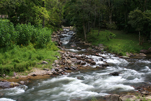
The park's landscapes feature dense Atlantic Rainforest covering rolling hills and steep escarpments, interspersed with crystal-clear streams, waterfalls, and panoramic viewpoints. Notable features include the Morro do Sapo Trail, leading to a 718-meter summit with views of Blumenau and surrounding peaks; numerous riachos (small streams) ideal for bathing; and forested valleys teeming with wildlife. The area boasts 38 hiking trails, many traversing lush forests with opportunities for birdwatching and photography. Waterfalls and natural pools add to the scenic appeal, while remote sections offer wild camping spots. The park's untouched nature provides a serene, immersive experience in one of Santa Catarina's most preserved forest fragments.
As part of the threatened Atlantic Forest biome, the park is crucial for protecting endemic species and maintaining ecological connectivity in a fragmented landscape. Key threats include poaching (especially of carnivore prey, leading to human-wildlife conflicts), deforestation from nearby agriculture, invasive species, and climate change impacts like altered rainfall patterns. Conservation efforts, led by ICMBio, include the Carnivores Conservation Project (started 2009), which uses camera traps, community surveys, and awareness campaigns to monitor pumas and minimize livestock predation. Other initiatives involve ecological restoration, biodiversity inventories (e.g., on insects and amphibians), and volunteer programs for monitoring. The park contributes to Brazil's biodiversity goals under the CBD, with ongoing research emphasizing habitat protection and conflict resolution.
As of August 2025, Serra do Itajaí National Park remains actively managed by ICMBio, with no major boundary changes or closures reported. Recent efforts include expanded volunteer opportunities (e.g., calls in 2020-2022) and research publications on flora, fauna, and restoration (2022-2024). Visitor access continues to require prior authorization, and the park is integrated into broader initiatives like the SALVE system for species monitoring. External pressures persist, including regional development in the Itajaí Valley, but conservation projects, such as carnivore monitoring, show progress in reducing threats. No significant incidents or expansions were noted in 2024-2025 updates, indicating stable operations focused on sustainability.
The park attracts eco-tourists, hikers, and nature enthusiasts for
its trails and wildlife, though it emphasizes low-impact visitation
due to its protected status.
Top Activities and Attractions:
Hiking on 38 trails, including Trilha do Morro do Sapo (moderate, ~5
km round-trip, 4-5 hours; features shaded forest paths, viewpoints,
and streams).
Wildlife observation (birds, mammals) and
photography in forested areas.
Swimming in natural pools and
streams during warmer months.
Wild camping in designated spots
for immersive experiences.
Practical Tips:
Best Time: Dry
season (April-September) for easier trails; avoid summer
(December-February) due to high heat and humidity.
Access and
Fees: Entry is free but requires prior authorization from ICMBio
(phone: +55 47 3326-1527; email:
parnaserradoitajai.sc@icmbio.gov.br). No walk-ins allowed.
Getting There: Drive from Blumenau (~30-60 km) or Brusque; public
transport limited—use taxis or tours. Park at entrance guardhouse.
Regulations: Mandatory guides for some trails; no pets, fires, or
collecting. Pack water (700ml+), repellent, sunscreen, snacks, and
sturdy shoes. Respect wildlife and leave no trace.
Accommodations: Limited inside; stay in nearby towns like Indaial or
Blumenau (hotels, pousadas). Camping requires permits.
Nearby:
Combine with Serra do Tabuleiro State Park or Blumenau's cultural
sites.
Visitors praise the park's preserved nature but note
physical demands—prepare for a rewarding, adventurous escape.