Lubaantun (also spelled Lubantuun, meaning “Place of Fallen Stones” in Yucatec Maya) is a Late Classic Maya archaeological site in the Toledo District of southern Belize, near the village of San Pedro Columbia. Flourishing primarily from AD 700 to 900, it was a regional ceremonial and administrative center known for its distinctive masonry, large plazas, and ballcourts. Lubaantun’s strategic location along trade routes connecting the Caribbean coast to the Maya interior supported its role in exchanging goods like cacao, salt, and obsidian. The site gained fame in the 1920s due to the alleged discovery of the “Crystal Skull of Doom” by Anna Mitchell-Hedges, though this artifact’s authenticity is widely disputed. Despite heavy looting and environmental challenges, Lubaantun remains a key site for understanding southern Belize’s Maya heritage, with ongoing community efforts to promote its preservation and tourism.
Location and Regional Context
Lubaantun sits at
coordinates 16°16′54″N 88°57′34″W, approximately 42 km (26 mi) northwest
of Punta Gorda (the district capital) and just 3.2 km (2 mi) from the
Maya village of San Pedro Columbia. It lies at an elevation of about 61
m (200 ft) above mean sea level.
The site occupies the foothills of
the Maya Mountains on the south-facing slopes of the Maya Mountains
Massif, a rugged upland core that dominates inland southern Belize and
extends into eastern Guatemala. This positions Lubaantun within or
immediately adjacent to the Columbia River Forest Reserve (also known as
Columbia Forest Reserve), one of the largest tracts of relatively
undisturbed tropical rainforest in Central America (roughly 60,000
hectares / 148,000 acres). The reserve features complex karstic
limestone terrain with elevations ranging from ~300–1,100 m in broader
protected areas, though Lubaantun itself is on lower ridges.
The
surrounding landscape includes rolling hills, dense jungle, and fertile
valleys that historically supported agriculture. On clear days, views
from the site’s plazas extend eastward toward the Caribbean Sea,
highlighting its transitional position between inland mountains and
coastal lowlands.
Topography and Site Layout
Lubaantun is
built atop a natural hill ridge or plateau that the Maya extensively
modified. The central core rests on a large, artificially raised
platform situated between two small rivers (tributaries) that converge
nearby. This hilltop location provided natural elevation and
defensibility, with the rivers acting as barriers.
The site spans
roughly 40 acres (16 hectares) along a linear north-south axis. It
incorporates broad terraces, plazas, and platforms supported by
retaining walls that follow the natural contours of the ridge.
Structures (about 14 major ones, including pyramids, ball courts, and
elite residences) are arranged on leveled terraces, with the Maya having
removed portions of the hilltop to create flat building
surfaces—essentially sculpting the mountain itself.
A distinguishing
feature is the use of large, precisely fitted black slate blocks (a
locally available metamorphic rock) laid without mortar, unlike the
limestone typical of many other Maya sites. Corners are often rounded,
and the construction exploits the natural geology of the southern Belize
foothills, where interbedded slates and other sedimentary rocks occur
rather than the purer limestones of the central lowlands.
Hydrology
The site’s position is intimately tied to water. It lies at
the head of canoe navigation on the Columbia River (sometimes called
Colombia River locally), a tributary system feeding into the broader Rio
Grande watershed that flows eastward to the coastal plain. Two small
streams flank the central platform, enhancing its strategic and
practical value for trade, transport, and defense.
The broader region
features karstic features (caves, disappearing streams) in higher
limestone areas of the Maya Mountains and reserve, but at Lubaantun’s
lower elevation, surface streams are more consistent. These rivers were
vital to ancient Maya logistics, connecting inland sites to coastal
trade networks.
Climate
Lubaantun experiences a tropical,
warm, and humid climate typical of southern Belize’s Toledo District—the
wettest part of the country. Annual rainfall averages 3,000–4,000+ mm
(118–160+ inches), heavily influenced by orographic lift: northeast
trade winds carry moisture from the Caribbean, which rises over the Maya
Mountains and drops heavy precipitation, especially on east-facing
slopes.
Wet season: June through December/January, with peaks
during the hurricane season (July–October/November).
Dry season:
February to mid-May (though even then, rain is possible).
Temperatures: Mean highs of 28–33°C (82–91°F) year-round, with slightly
cooler conditions in the foothills than on the immediate coast; humidity
remains high.
This climate supports dense vegetation but also
contributes to challenges like erosion on slopes and seasonal flooding
in lower river valleys.
Vegetation and Ecology
The environment
is classic tropical broadleaf rainforest (subtropical lower montane wet
forest in higher nearby elevations). Rich, fertile soils derived from
the Maya Mountains’ geology make the area excellent for traditional Maya
crops like cacao and maize—evident both in ancient times and modern Maya
villages nearby.
The Columbia Forest Reserve and surrounding hills
host high biodiversity, with dense canopy, understory palms, vines, and
epiphytes. The site itself is partially cleared for archaeology but is
immediately bordered by tall forest, creating a serene, bird-rich
setting (notable for birdwatching). Fauna includes typical Central
American rainforest species (howler and spider monkeys, birds like
toucans and parrots, and larger mammals in the deeper reserve).
Lubaantun (also spelled Lubaantún) is one of the most
intriguing and distinctive ancient Maya archaeological sites in southern
Belize. Located in the Toledo District near the village of San Pedro
Columbia, about 26 miles northwest of Punta Gorda and roughly 1 mile
north of the Columbia River, it sits on a naturally elevated ridge at
around 200 feet above sea level, strategically positioned at the head of
canoe navigation where two small tributaries converge.
The modern
Maya name Lubaantun translates to “Place of Fallen Stones,” reflecting
the site’s dramatic, rubble-strewn appearance today—though its original
ancient name remains unknown. Spanning approximately 40 acres (with the
main ceremonial core measuring about 900 feet long and 600 feet wide),
it flourished briefly during the Late Classic period of Maya
civilization (roughly AD 700–900, with peak activity from the 730s to
the 890s) before being completely abandoned around AD 900, with no
evidence of Postclassic reoccupation.
Ancient Origins and
Occupation (c. 700–900 AD)
Lubaantun emerged relatively late in the
Maya Classic era, likely founded around AD 700 as a planned or
politically sponsored center, possibly by neighboring polities such as
Pusilha or Uxbenka to the south. Its location was deliberate: it
controlled access to rich ecological resources (including cacao-growing
lands) and pre-existing regional trade networks along rivers that
facilitated canoe transport to the coast.
Archaeologists interpret it
as a local capital and thriving commercial/ceremonial hub rather than a
major political powerhouse like Tikal or Caracol. Evidence points to it
being a key production center for cacao (chocolate beans, a Maya luxury
good and currency), supported by ceramic and stone effigies depicting
cacao pods. It also participated in broader trade, including salt from
coastal sites and obsidian tools. Population density is estimated at
around 600 people per square kilometer, with a likely Ch’olan Maya
dialect spoken.
The site’s short lifespan—only about 150–170 years of
intensive occupation—mirrors the broader “Maya collapse” or
transformation in the southern lowlands during the Terminal Classic. It
was abandoned by the early 10th century, possibly due to environmental
stress, overpopulation, shifting trade routes, or political upheaval
common across the region at the time.
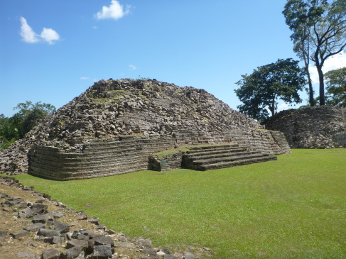
Unique Architecture and
Urban Layout
Lubaantun stands out for its unconventional construction
techniques, differing markedly from the limestone-and-mortar style
typical of most Maya sites. Builders used large, precisely cut blocks of
black slate (sourced locally) laid in drystone masonry—no mortar at all.
Key features include:
“In-and-out” masonry: Each tier of walls
has a slight batter (inward slope), with every second course of stones
projecting outward, creating a distinctive stepped, interlocking look.
Rounded corners on step-pyramids (unlike the sharp angles elsewhere).
No vaulted stone roofs or superstructures on pyramids—likely topped with
perishable thatch or wood buildings.
Large, artificially terraced
platforms and plazas supported by retaining walls, with two major
pyramids rising about 40 feet.
An acropolis-like core with
discernible public open spaces and more private enclosed areas.
At
least three ballcourts (Mesoamerican ritual/game courts), including one
with carved stone markers showing ballplayers and hieroglyphs (now at
Harvard’s Peabody Museum).
The entire complex sits on a defensive
ridge between two rivers, suggesting military considerations. Unlike
many Maya centers, there are no stelae (carved stone monuments) or
extensive glyphic inscriptions, making it harder to reconstruct specific
rulers or dynastic history. This absence, combined with the unique
building style, gives the site a somewhat “utilitarian” or regional
character compared to grander lowland cities.
Artifacts and
Material Culture
Excavations have yielded a wealth of everyday and
ritual items that illuminate daily life and beliefs:
Ceramic whistle
figurines (ocarina-like objects with finger holes, producing three
notes): Lubaantun is famous for these mass-produced, mold-made
pieces—hundreds have been found. They depict everyday people, warriors,
ballplayers, officials in regalia, cosmological figures, and even masked
performers. Styles include “chubby” (rounded faces) and “classical”
(with cranial modification and ornaments). Many are thought to have
served ritual or musical purposes.
Pottery in Tepeu 2 and 3 styles
(painted and molded), metates/manos (grinding stones), obsidian blades,
shell ornaments, ear/nose plugs, and cacao-related effigies.
A
notable family tomb excavated in the 1970s contained remains of about 15
adults (mixed sexes and ages) showing signs of malnutrition and dental
issues, with multiple burials over roughly a century.
These finds
highlight a vibrant craft tradition tied to ritual, music, agriculture,
and trade.
Excavation and Modern History
The site was known
locally to Kekchi and Mopan Maya communities and first formally reported
to British colonial authorities in the late 19th century (initially
called “Rio Grande Ruins”).
1903: Dr. Thomas Gann (Belize’s chief
medical officer and amateur archaeologist) investigated on behalf of the
British Honduras government and published reports.
1915: R.E. Merwin
(Harvard Peabody Museum) mapped the site, cleared vegetation, and
discovered ballcourts with carved markers.
1924: Gann returned with
adventurer F.A. Mitchell-Hedges; he formally named the site Lubaantun
and used (controversial) dynamite in places.
1926–1927: British
Museum expeditions led by T.A. Joyce (and later J. Eric S. Thompson)
conducted systematic digs, establishing the mid-to-late Classic
chronology and documenting the unique masonry. Many artifacts went to
the British Museum.
1970–1973: Major scientific project by Norman
Hammond (Cambridge University, with British Museum and Harvard support),
including Kate Pretty and Frank P. Saul. They produced a new map,
excavated the family tomb, and confirmed the brief Late Classic
occupation.
Later work by Geoffrey Braswell and the Belize
Institute of Archaeology has focused on regional interactions and
conservation. The site now has a visitor center, trails, and is managed
by the National Institute of Culture and History (NICH). It remains
relatively uncrowded compared to larger Maya sites.
The Crystal
Skull Controversy
Lubaantun gained pop-culture fame through the
alleged 1924 (or 1926) discovery of the “Mitchell-Hedges Crystal Skull”
by Anna Mitchell-Hedges (F.A.’s adopted daughter), supposedly found
under a collapsed altar on her 17th birthday. Promoted as an ancient
Maya (or even older) artifact with mystical powers, it became a New Age
icon. However, extensive investigations (including by Norman Hammond,
Joe Nickell, and Smithsonian experts) have thoroughly debunked this: no
excavation records mention it, expedition members denied Anna’s
presence, and the skull was likely a 19th-century European forgery
(possibly made with modern tools) purchased by Mitchell-Hedges at a 1943
Sotheby’s auction from a London collector. It has no connection to
Lubaantun or pre-Columbian Belize.
Lubaantun’s archaeological features, studied through
early 20th-century excavations and modern surveys, highlight its
distinctiveness:
Architecture:
Unique Masonry: Lubaantun is
renowned for its finely cut, mortar-free stonework, using precisely
shaped limestone and slate blocks. Unlike typical Maya construction with
lime plaster, Lubaantun’s buildings rely on interlocking stones, giving
structures a polished, curved appearance. This “in-and-out” masonry,
seen in pyramids and platforms, is rare in the Maya world and suggests
specialized craftsmanship.
Plazas and Structures: The site covers
approximately 1 km², with 11 major plazas, five ballcourts, and over 50
structures, including pyramids, platforms, and residences. The main
acropolis, elevated on a ridge, features three large plazas (Plazas IV,
V, VI) used for ceremonies. The ballcourts, among the largest in
southern Belize, indicate the importance of the Mesoamerican ballgame in
political and religious life.
Artifacts:
Ceramics and
Figurines: Excavations uncovered ceramic figurines, often depicting
deities or elites, used in rituals. Belize Red ceramics, common in
burials, link Lubaantun to regional trade networks. Whistling vessels
and ocarinas suggest musical traditions.
Obsidian and Shell: Obsidian
blades and marine shell ornaments reflect trade with the highlands
(e.g., Guatemala) and coast, underscoring Lubaantun’s economic role.
Crystal Skull Controversy: The alleged 1926 find of a quartz crystal
skull by Anna Mitchell-Hedges, claimed to be a Maya artifact, is widely
debunked. Scientific analyses (e.g., Smithsonian studies) show it was
likely crafted in the 19th century using modern tools, possibly in
Europe. Its association with Lubaantun, promoted by Mitchell-Hedges’
sensationalist claims, has skewed public perception, though it remains a
pop-culture icon.
Ballcourt Markers: Three inscribed ballcourt
markers, similar to those at Pusilhá, depict ritual scenes and
hieroglyphs, though their texts are less detailed than stelae at other
sites. These markers highlight Lubaantun’s engagement in regional
ballgame traditions.
Settlement Patterns: The site’s compact layout
suggests a centralized polity with elite residences near plazas and
commoner housing on the periphery. Agricultural terraces and cacao
groves supported a dense population, estimated in the thousands.
Lubaantun’s architectural innovation and artifact assemblage make it a
key site for studying Late Classic Maya urbanism, though looting and the
Crystal Skull narrative have complicated its legacy.
Lubaantun holds cultural importance for both scholarly
research and modern Belizean communities:
Maya Heritage: As a
Late Classic center, Lubaantun showcases the Maya’s architectural
ingenuity, trade networks, and ritual life. Its ballcourts and figurines
reflect a vibrant ceremonial culture, while its trade role highlights
southern Belize’s integration into the broader Maya world.
Local
Communities: The nearby Q’eqchi’ and Mopan Maya villages, such as San
Pedro Columbia, view Lubaantun as ancestral heritage. Community-led
initiatives, supported by groups like the Toledo Maya Cultural Council,
promote the site as a cultural and tourism asset, fostering local pride
and economic opportunities.
Global Recognition: The Crystal Skull,
despite its dubious origins, has made Lubaantun a recognizable name in
popular culture, featured in films like Indiana Jones and the Kingdom of
the Crystal Skull. While this fame draws interest, it often overshadows
the site’s authentic archaeological value.
Lubaantun bridges ancient
Maya achievements with modern cultural identity, serving as a symbol of
resilience for Toledo’s Maya communities.
Research at Lubaantun has been sporadic but
significant:
Early Excavations: Thomas Gann’s 1903–1905
surveys and British Museum expeditions in 1915 and 1926–1927
documented Lubaantun’s architecture and artifacts. Norman Hammond’s
1970s work clarified its chronology, confirming its Late Classic
focus. These early studies, while foundational, removed many
artifacts to foreign museums, sparking repatriation debates.
Recent Efforts: Modern research is limited due to looting and
funding constraints, but community-driven surveys and conservation
projects continue. The Belize Institute of Archaeology oversees the
site, with efforts to stabilize structures and curb looting.
Archaeological tours, often led by local guides, provide data
through visitor observations.
Tourism Development: Lubaantun is a
growing tourism destination, accessible via paved roads from Punta
Gorda. Visitor centers offer guided tours, highlighting the site’s
masonry and ballcourts. Community initiatives aim to integrate
Lubaantun into eco-tourism circuits, alongside Nim Li Punit and
Uxbenká, to boost Toledo’s economy.
Crystal Skull Debates:
Ongoing scholarly analyses, such as those by the British Museum and
Smithsonian, have debunked the Crystal Skull’s Maya origins,
redirecting focus to Lubaantun’s authentic artifacts. Public
interest in the skull, however, sustains tourism, creating a complex
dynamic.
Current efforts prioritize preservation and community
engagement, though Lubaantun lags behind sites like Caracol in
research investment.