Nohmul (meaning “Great Mound” in Yucatec Maya) is a major Pre-Columbian Maya archaeological site in the Orange Walk District of northern Belize, near the Hondo River and the village of San Jose. Occupied from the Middle Preclassic (ca. 1000 BC) through the Terminal Classic (ca. AD 900–1000), Nohmul was a significant regional center, likely controlling trade and agriculture in northern Belize. The site is renowned for its large pyramid, extensive settlement, and evidence of Yucatec influence in its later phases. Tragically, in 2013, a construction company bulldozed much of Nohmul’s main pyramid to extract road fill, sparking global outrage and highlighting preservation challenges. Despite this loss, Nohmul remains a key site for understanding Maya urbanism, trade, and cultural transitions, with ongoing efforts to protect its remnants.
Precise Location and Regional Context
Nohmul sits near the village
of San Pablo, roughly 10 km (6 mi) north of Orange Walk Town and about 2
km east of the Hondo River (Rio Hondo), which forms the modern
international border between Belize and Mexico. Its exact coordinates
are approximately 18°13′2″N 88°35′5″W (18.217°N, 88.585°W).
This
places it in northern Belize’s coastal plain, part of the broader
Yucatán Platform—a geologically stable limestone karst region extending
from Mexico into northern Belize. Unlike southern Belize’s rugged Maya
Mountains, northern Belize features low, rolling terrain with elevations
generally under 30 m above sea level. Nohmul occupies about 35 km² (14
sq mi), making it the largest Maya site in northern Belize, with around
700 visible mounds (small structures 10–30 m in diameter and 1–5 m high)
scattered across the area.
The site’s ceremonial and urban core
unusually spans the crest of a prominent limestone ridge—the highest
local point and visible for many kilometers in the flat landscape. This
ridge overlooks the Hondo River to the west, providing both defensive
oversight and control over riverine trade routes that linked inland
areas to the Caribbean coast.
Topography and Landforms
The
immediate setting is predominantly flat tropical lowlands with fertile,
limestone-derived soils. The central ridge rises modestly (elevation
~20–23 m above sea level) above the surrounding plain and sluggish
river. The ridge’s crest hosts the main East and West Groups of plazas
and structures (linked by a raised causeway or sacbe), including a large
acropolis and the once-prominent pyramid (largely destroyed in 2013 for
road fill).
To the east lies the western arm of Pulltrouser Swamp, a
large Y-shaped wetland depression between the Hondo and New Rivers. This
swamp and associated bajos (seasonal wetlands) were integral to the
site’s economy. Ancient Maya inhabitants engineered extensive raised and
channelized fields here for intensive agriculture, using canals for
drainage, irrigation, and transport. These hydraulic systems date
primarily to the Late Classic/Terminal Classic periods (ca. 700–1000 CE)
and supported maize, root crops, and other staples.
The broader
landscape consists of low limestone hills, escarpments, and karst
features typical of the Yucatán Platform. Soils on the ridge are
well-drained and fertile (shallow mollisols), while swamp margins
feature heavier clays and organic mucks. Today, the area is dominated by
commercial sugarcane fields, which obscure many of the smaller mounds
and highlight the continuity of intensive agriculture in the region.
Hydrology
The Hondo River—a permanent, slow-moving waterway—was
central to Nohmul’s geography and economy. It provided reliable water,
fish, and a major canoe trade corridor connecting the interior Maya
lowlands to coastal ports. The river’s proximity (just 2 km west of the
ridge) allowed the site to function as a trade hub, with evidence of
cultural influences from both the Petén region (south) and Yucatán
(north).
Adjacent wetlands like Pulltrouser Swamp offered additional
water management opportunities but also posed challenges such as
seasonal flooding. The Maya adapted by creating artificial fields and
canals, turning these bajos into productive agricultural zones rather
than obstacles.
Climate
Nohmul experiences a tropical savanna
climate (Köppen Aw)—hot, humid, and markedly seasonal. Average
temperatures range from 75–85°F (24–29°C) year-round, with little
variation. Annual rainfall in northern Belize is lower than in the
south: roughly 1,300–2,000 mm (51–80 inches), concentrated in the wet
season (roughly May/June to November/December). The dry season
(February–April) brings significantly less rain, sometimes under 100 mm
per month.
This seasonality influenced Maya agriculture and
settlement: wetlands could flood during the wet months, while the ridge
provided drier, elevated ground for major construction. Occasional cold
fronts from North America can bring brief cooler weather in winter.
Vegetation and Modern Landscape
Originally, the area lay near the
ecological transition between denser central lowland rainforest and
sparser northern scrub-forest. Wetlands supported escoba-botan swamp
vegetation, while higher ground had tropical broadleaf forest. Pollen
and soil studies from nearby Pulltrouser Swamp indicate a shift from
littoral/marsh environments to managed agricultural landscapes during
Maya occupation.
Today, centuries of clearing and modern sugarcane
cultivation dominate. The site is largely hidden within cane fields on
private land, with the remaining mounds appearing as low rises amid the
agricultural matrix. This human-modified environment underscores both
the fertility that sustained ancient populations and ongoing threats to
archaeological preservation.
Nohmul (also spelled Noh Mul, meaning "great mound" or "big mound" in
Yucatec Maya) is one of the largest and most significant pre-Columbian
Maya archaeological sites in northern Belize. Located in the village of
San Pablo, Orange Walk District, approximately 10 km north of Orange
Walk Town, it sits on a limestone ridge overlooking the Hondo River.
This strategic position allowed the ancient Maya to control regional
trade routes along the river and nearby wetlands. The site spans about
35 square kilometers (14 square miles), with roughly 700 visible mounds
(ranging from small house platforms to larger ceremonial structures),
making it the most important Maya center in northern Belize.
Nohmul
was never heavily developed for tourism (unlike sites such as
Xunantunich or Caracol), but it played a key role in understanding Maya
settlement patterns, trade, and cultural interactions in the lowlands
near the Yucatán Peninsula. Its history spans from the Middle Preclassic
period through the Terminal Classic/Early Postclassic, with evidence of
two major phases of monumental construction separated by a period of
decline. Much of what we know comes from early 20th-century explorations
and systematic excavations in the 1970s–1980s, though a major 2013 event
dramatically altered one of its most prominent features.
Preclassic Origins and Early Monumental Construction (c. 350 BC–5th
Century AD)
Nohmul was founded during the Preclassic (or Formative)
era of Maya civilization, with initial occupation dated to around 350
BC–250 AD. A large pyramid, standing about 17 meters (56 ft) tall with a
base of roughly 50 by 52 meters, was constructed around 250 BC (or
possibly as early as 300 BC). This structure formed part of the site's
early ceremonial core.
The site experienced significant growth in the
Late Preclassic (Late Formative) period, when monumental building
activity peaked. Like many northern Belizean sites (e.g., Cerros,
Lamanai, and Cuello), Nohmul benefited from fertile wetlands and river
access, supporting intensive agriculture—including drained-field systems
in the surrounding lowlands—and trade. Obsidian and other goods indicate
connections extending to central Mexico.
By the Early Classic period
(roughly 5th century AD), large-scale construction largely ceased. The
site appears to have declined or been mostly abandoned, with only
scattered rural-domestic activity continuing. Excavations revealed an
"acropolis" area with a major timber building dated to ca. 200–300 AD
(still transitional Preclassic–Early Classic), associated with green
obsidian from central Mexico. This structure was later abandoned until
recolonization centuries later.
Revival in the Late Classic and
Terminal Classic/Early Postclassic (7th–10th/12th Centuries AD)
After
a hiatus of several centuries, Nohmul was reoccupied on a large scale
during the Late Classic period (c. 7th–10th centuries AD). This marked
the site's second major phase of monumental building and its period of
peak density and activity. The ceremonial precinct—divided into an East
Group (larger and more intensively studied) and a West Group, connected
by a raised causeway (sacbe)—featured at least ten plazas and over 80
structures. Many were built or adapted during this time.
Key Late
Classic/Terminal Classic features include:
A "range" (long,
multi-roomed) palace structure.
A pyramid (built over earlier
abandoned structures).
A ballcourt, which overlay densely packed
perishable buildings from ca. 700–900 AD and dated to a very late phase
(ca. 800–1000 AD).
In the Terminal Classic to Early Postclassic
transition (ca. 800–1000 AD), later residents—possibly migrants or
influenced by groups from the northern Yucatán Peninsula—constructed
structures in a northern Yucatán architectural style directly over older
Classic-era buildings. One example resembled El Caracol at Chichén Itzá.
This suggests cultural or population shifts, perhaps linked to broader
Maya "collapse" dynamics in the southern lowlands while northern Belize
and Yucatán sites showed continuity.
The site served as the seat of
government for a polity covering roughly 8 square miles (21 km²) and
remained densely occupied into the early Postclassic, with some evidence
of activity extending to the 12th century before final abandonment after
the 10th century.
Archaeological Discovery and Excavations
The
first published reference to Nohmul appeared in 1897 in Thomas Gann's
paper "On the Contents of Some Ancient Mounds in Central America." Gann,
a British medical officer and amateur archaeologist, conducted
excavations at the site between 1908 and 1936. Artifacts he recovered,
including ceramics and other items, are now housed in the British Museum
in London.
Modern scientific work began in 1973 when British
archaeologist Norman Hammond mapped the prehistoric features. Hammond
led "The Nohmul Project" in the 1980s, with major seasons in 1982, 1983,
and 1985. His team's work included:
Detailed mapping of the
settlement and ceremonial core.
Test excavations across the site.
Investigations of drained-field agriculture in the wetlands.
Excavations in the East Group that clarified the early (ca. 200–400 AD)
and late (ca. 800–1000 AD) phases of activity.
These efforts
produced comprehensive reports (e.g., Hammond's 1985 two-volume BAR
publication Nohmul: A Prehistoric Maya Community in Belize) and
established Nohmul as a key case study for understanding
Preclassic-to-Postclassic transitions in northern Belize.
Modern
History, Destruction, and Legacy
All ancient Maya sites in Belize are
legally protected as national monuments, regardless of private land
ownership. However, Nohmul faced ongoing threats from agriculture
(cane-field burning) and looting.
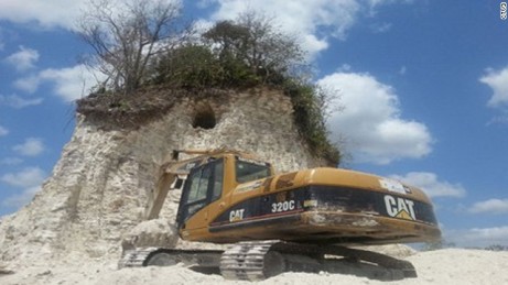
On May 13, 2013, contractors from
De-Mar's Stone Company (owned by local politician Denny Grijalva) used
bulldozers and excavators to demolish more than 70% of the site's
central pyramid (the large Preclassic structure) for limestone gravel to
build roads in nearby Douglas Village. The 17-meter-tall mound was
unmistakable in the flat landscape, yet work continued until halted by
authorities. Only the core remained.
The Belize Institute of
Archaeology (under the National Institute of Culture and History)
investigated, describing it as willful destruction. Charges were filed
in June 2013 against the foreman, driver, and company owners. In April
2016, three individuals were convicted and fined BZ$6,000 each (plus the
company), with the owner issuing an apology. The incident drew
international condemnation (including from National Geographic) and
highlighted vulnerabilities of unprotected or unexcavated Maya sites in
Belize. Similar events occurred at other sites, such as San Estevan in
2005.
As of recent references (into the 2020s), Nohmul remains a
powerful symbol of both Maya heritage and the challenges of site
preservation in Belize, where hundreds of Maya ruins exist but few are
fully excavated or protected from development pressures.
Nohmul’s archaeological features, documented through excavations in
the 1980s and earlier surveys, highlight its role as a major Maya city:
Architecture:
Main Pyramid (Structure 2): The site’s centerpiece
was a 56-foot-tall pyramid, built around 250 BC, with a broad platform
and multiple phases of construction. It served ceremonial and political
functions, housing elite tombs and rituals. Tragically, this structure
was largely demolished in 2013 by bulldozers, leaving only a small core
intact.
Plazas and Complexes: Nohmul covers approximately 20 km²,
with multiple plazas, temples, and residential areas. The East Group,
including Structure 2, was the ceremonial core, while the West Group
featured administrative and elite residences. An acropolis and causeways
(sacbeob) connected key areas, reflecting urban planning.
Ballcourt:
A ballcourt, typical of Maya civic centers, hosted ritual games tied to
political and religious life. Its presence underscores Nohmul’s regional
status.
Artifacts:
Ceramics: Excavations uncovered a rich
ceramic sequence, from Preclassic Swasey and Bladen types to Terminal
Classic Yucatec-influenced wares. These link Nohmul to trade networks
across the Maya lowlands and Yucatán.
Chert and Obsidian: Nohmul was
a hub for chert tool production, with evidence of specialized workshops.
Obsidian blades, sourced from Guatemala, indicate long-distance trade.
Burials and Offerings: Elite burials with jade, shell, and ceramic
offerings reflect social stratification. Commoner households, studied in
settlement surveys, show a diverse population.
Settlement Patterns:
Nohmul’s extensive settlement, mapped in the 1980s, includes over 700
structures, from elite palaces to commoner houses. Raised fields and
canals supported intensive agriculture, sustaining a population
estimated in the thousands.
Yucatec Influence: Terminal Classic
ceramics and architectural features, such as corbelled arches, suggest
cultural ties to the Yucatán, possibly reflecting migration or trade
with Chichén Itzá.
Nohmul’s archaeological record, despite the 2013
loss, provides critical insights into Maya urbanism, trade, and cultural
transitions, particularly its late adaptation to northern influences.
Nohmul holds significant cultural value for both scholarly research
and modern Belizean communities:
Maya Heritage: As northern
Belize’s most important Maya site, Nohmul showcases the region’s role in
Maya civilization, bridging Preclassic origins with Terminal Classic
innovations. Its trade networks and Yucatec connections highlight
northern Belize’s integration into the broader Maya world.
Local
Communities: The nearby villages of San Jose and Douglas, primarily
Mestizo and Yucatec Maya, view Nohmul as ancestral heritage. The 2013
destruction galvanized local advocacy for heritage protection, with
communities calling for stronger laws and site management.
Global
Awareness: The bulldozing incident, reported by National Geographic,
BBC, and others, raised global awareness of Nohmul and the broader
threat to Maya sites. It sparked discussions about balancing development
with cultural preservation, positioning Nohmul as a cautionary tale.
Nohmul’s cultural significance lies in its historical depth and its
modern role as a symbol of heritage under threat, resonating with
Belize’s ongoing efforts to protect its Maya legacy.
Research at Nohmul has been shaped by both archaeological progress
and the 2013 destruction:
Historical Excavations: Early work by
Thomas Gann in the 1930s and Norman Hammond’s surveys in the 1980s
(e.g., 1983 and 1985) mapped Nohmul’s settlement and documented its
ceramics and chert production. These studies established Nohmul as a
major center with a continuous occupation.
Post-2013 Efforts: The
2013 destruction, perpetrated by D-Mar Construction for road fill,
prompted emergency assessments by the Belize Institute of Archaeology.
While the pyramid’s core was partially salvaged, the loss curtailed
large-scale excavations. Recent research focuses on peripheral
structures and settlement patterns, using remote sensing to identify
unlooted areas.
Tourism and Conservation: Nohmul is listed as an
attraction by Lonely Planet, but its damaged state and remote location
limit tourism. The Belize government has increased patrols and community
engagement to prevent further looting, though funding remains limited.
Local groups advocate for Nohmul’s inclusion in eco-tourism circuits,
alongside sites like Lamanai.
Legal and Policy Response: The 2013
incident led to fines for the construction company, but critics argue
the penalties were insufficient. It spurred calls for stricter heritage
laws, influencing policies for other Belizean sites.
Current efforts
prioritize salvage archaeology and advocacy, though Nohmul’s reduced
physical presence hinders its research and tourism potential.