Nohoch Che’en, commonly referred to as Caves Branch, is a prominent archaeological reserve and adventure destination in the Cayo District of central Belize. Renowned for its extensive network of limestone caves carved by the Caves Branch River, it is one of Belize’s top attractions for cave tubing, kayaking, and exploring ancient Maya history. The name "Nohoch Che’en" translates to “Great Cave” in Yucatec Maya, reflecting its significance as both a natural wonder and a sacred site for the ancient Maya. Spanning a lush jungle landscape, the reserve offers a unique blend of adrenaline-pumping activities, geological marvels, and cultural heritage, drawing thousands of visitors annually, from cruise ship tourists to archaeology enthusiasts.
Location and Accessibility
Nohoch Che'en lies in the Cayo
District, in the foothills of the Maya Mountains, roughly in the
geographic center of Belize. Its approximate coordinates are 17.2067°N,
88.6533°W (or plus code 79G4+QM near Belmopan). The reserve sits along
the Caves Branch River at about Mile 37 on the George Price Highway
(formerly Western Highway), between Belize City and Belmopan/San
Ignacio. It is approximately 1 hour west of Belize City or 30–45 minutes
from Belmopan, with a short access road (around 7 miles off the main
highway in some descriptions) leading to the park entrance and visitor
facilities.
The core protected area was declared a 15.5-acre
archaeological reserve by the Belize government in 2010, though the
broader cave system and river valley extend farther through the
surrounding karst terrain. It is north of Belmopan and part of the
larger Caves Branch River Valley.
Topography and Geology
The
site exemplifies a mature (old-age) tropical karst landscape formed
primarily from Cretaceous limestone (approximately 100–65 million years
old). These are often highly brecciated (fractured and fragmented) and
non-bedded limestones on the periphery of the Maya Mountains. Karst
develops through chemical dissolution: rainwater absorbs carbon dioxide
from the atmosphere and soil, becoming mildly acidic (carbonic acid)
that slowly dissolves the soluble limestone over millennia. This creates
classic features like caves, sinkholes (dolines), disappearing streams,
and underground drainage with minimal surface rivers in some areas.
In this "old-age" karst stage, the landscape shows advanced erosion:
collapsed cave roofs form karst windows (openings where the river
briefly flows on the surface before re-entering caves). The topography
consists of rolling limestone hills and low ridges covered in dense
vegetation, with elevations around 200–300 meters (e.g., Caves Branch
area averages ~214 m). The Maya Mountains foothills provide a
transitional zone between the higher, more rugged interior mountains to
the south and the flatter coastal plains to the east.
The Caves
Branch Cave System (also called the Nohoch Che'en or Caves Branch River
Cave System) is one of Belize's largest documented networks. It includes
an extensive series of interconnected limestone caves—estimates mention
about 19 caves in the immediate reserve area, with over 28 miles (45 km)
of passages surveyed in the broader Caves Branch Valley. The river has
carved multiple passages (at least four main ones noted in some
descriptions), linking karst windows and creating a dynamic underground
fluvial system. Key caves in the vicinity include the main tubing cave
(often simply called Nohoch Che'en Cave), Petroglyph Cave, Pothunters
Cave, Satabe Cave, Footprints Cave, St. Margaret’s Cave, Pottery Cave,
Te Tun Cave, and others like the spectacular Crystal Cave (a side
passage extending several miles with extensive formations).
Stalactites, stalagmites, flowstones, rimstone dams, and other
speleothems (cave formations) are abundant, formed by mineral-rich
dripwater precipitating calcium carbonate. Some chambers contain ancient
Maya artifacts and evidence of ritual use, though the geography itself
focuses on the natural dissolution processes accelerated by Belize's
warm, humid tropical climate.
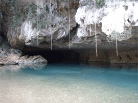
Hydrology: The Caves Branch River
The Caves Branch River is the defining hydrological feature. It is a
perennial stream that disappears into and emerges from the caves
multiple times, creating a classic "disappearing river" karst system.
During cave tubing or kayaking, visitors float through dark underground
sections (lit only by headlamps) interspersed with open jungle stretches
via karst windows. The river's flow has shaped the caves over hundreds
of thousands of years, with clear, cool waters supporting unique
cave-adapted life like eyeless (troglobitic) fish. Water levels can vary
seasonally, but the system is generally reliable for recreation due to
consistent underground drainage.
This is part of the larger karst
hydrology of central Belize, where much of the country's interior
(nearly 3,000 km² of karst) drains underground before resurfacing as
springs or rivers. The Caves Branch contributes to the Belize River
watershed ultimately.
Climate, Vegetation, and Ecology
Nohoch
Che'en experiences a tropical monsoon climate (Köppen Am), typical of
lowland Belize: hot and humid year-round with a distinct wet season
(May–November, including hurricane risks) and drier season
(December–April). Average temperatures hover around 25–30°C (77–86°F),
with high rainfall (often 2,000–3,000 mm annually in the foothills)
fueling the lush vegetation and cave-forming dissolution.
The surface
environment is dense tropical broadleaf rainforest (high-canopy
evergreen and semi-deciduous forest) with rich biodiversity. The jungle
hike to the cave entrance (typically 30–45 minutes, flat to moderate)
passes through thick understory, towering trees, and epiphytes. Wildlife
includes howler monkeys (often heard), various birds, coatimundis, and
other mammals; the caves host bats and specialized aquatic fauna. The
forested karst helps maintain high humidity and supports the river's
consistent flow.
Geological Formation (Millions to Hundreds of Thousands of Years Ago)
The caves’ story begins in the deep geological past. Millions of years
ago, during the Cretaceous period, most of what is now Belize lay
beneath a broad, shallow tropical sea. Limestone formed here through the
accumulation of calcium carbonate from marine organisms (corals,
mollusks, shells) and chemical precipitation from seawater. Storms
occasionally disturbed the seafloor, creating breccia limestone with
angular “rip-up clasts.”
These limestone layers were later uplifted
along the northern flanks of the Maya Mountains (whose core consists of
much older volcanic and metamorphic rocks). Acidic rainwater—enriched
with carbon dioxide from the atmosphere and decaying vegetation in the
tropical soil—percolated through joints and fractures in the soluble
limestone, dissolving it over time and creating a classic karst
landscape of caves, sinkholes, underground rivers, and disappearing
surface streams.
The Caves Branch River, a highly active waterway,
carved out the extensive cave network. Geological research shows the
system took several hundred thousand years to form. It is considered an
“old age” karst feature, with collapsed sections (karst windows),
meandering underground passages, scallops carved by turbulent flow,
variable gradients (possibly influenced by faults), and speleothems such
as stalactites, stalagmites, flowstone, and dripstone. These formations
continue to grow and occasionally redissolve during floods. The active
river still carries sand, gravel, and chert cobbles from the Maya
Mountains.
The full surveyed Caves Branch Cave System stretches
approximately 19 miles (about 30 km), with around 28 miles of caves
documented in the broader valley. The river flows through multiple
interconnected caves (originally one larger system before collapses),
and tours typically pass through 3–5 of them. Much of the system remains
unexplored or unmapped.
Ancient Maya Use and Cultural
Significance (Middle Preclassic to Postclassic Periods, ca. 1000
BCE–1500 CE)
For the ancient Maya, these caves were far more than
geological wonders—they were sacred portals to Xibalba, the underworld
described in the Popol Vuh as the “place of fear,” a dark realm ruled by
death gods and a crossroads between the living world and the afterlife.
Maya cosmology viewed caves as entrances to this subterranean domain,
where gods controlled rain, fertility, harvests, and fate. Priests,
rulers, and shamans entered them for rituals including ceremonies,
bloodletting, offerings, divination, sacrifices, and burials.
Archaeologists estimate that caves in the Nohoch Che'en / Caves Branch
area were used from the Middle Preclassic through the Postclassic
periods (roughly 1000 BCE to after 900 CE), primarily for burials and
ceremonies/rituals. Evidence includes:
Pottery shards, fire pits
with charcoal and ash, altars, and ceremonial artifacts (some left in
situ or noted by guides during tours).
Skeletal remains (human bones
possibly linked to sacrifices or burials).
Preserved Maya paintings
or glyphs high on cave ceilings (visible during cave tubing with
headlamps).
Occasional obsidian blades, jade items, or other ritual
objects.
A key excavated site within the broader Caves Branch
River Valley is the Caves Branch Rockshelter (CBRS). Excavations by the
Belize Valley Archaeological Reconnaissance (BVAR) project in 2005–2006
revealed it was used as a cemetery by a small farming community during
the Protoclassic period (ca. 100 BCE–250 CE). The skeletal population
was unusually representative—both sexes, all age groups, including a
high proportion of infants—suggesting a complete rural community sample
rather than the elite-biased burials common at major Maya centers. After
the main cemetery phase, other local groups made occasional visits. This
provides rare bioarchaeological insights into everyday Maya life in a
rural setting.
Other caves in the reserve (e.g., Petroglyph Cave,
Pothunters Cave, Satabe Cave, Footprints Cave, St. Margaret’s Cave,
Pottery Cave, Te Tun Cave) show similar patterns of ritual use. Nearby
St. Herman’s Cave (in an adjacent national park but part of the same
hydrological system) contains Classic-period artifacts like spears,
torches, and ceramics.
Unlike more dramatic sites such as Actun
Tunichil Muknal (ATM), Nohoch Che'en’s artifacts are less publicized in
detail (many were removed for safekeeping or remain protected), but the
caves clearly formed part of the widespread Maya practice of using
subterranean spaces for religious and ancestral veneration.
Modern History and Tourism Development (20th–21st Centuries)
The
caves remained largely known to local Maya descendants and early
explorers until the late 20th century, when Belize’s growing
adventure-tourism industry recognized their potential. The area was
previously associated with the “Jaguar Paw” outpost or resort name for
tours and lodging.
In 2010, the Belize government officially declared
the site the Nohoch Che'en Caves Branch Archaeological Reserve
(initially about 15.5 acres, though the cave system is far larger),
placing it under the protection of the Institute of Archaeology within
the National Institute of Culture and History (NICH). This status
preserves both its natural and cultural heritage while allowing
controlled public access.
Today, Nohoch Che'en is Belize’s premier
cave-tubing destination. Visitors hike through jungle, then float on
inner tubes (or kayak) through the cool, dark river passages, guided by
licensed experts who explain the geology, ecology (including eyeless
cave fish), and Maya history. Tours last 1.5–2+ hours and can combine
with ziplining, ATV rides, or visits to side passages like the Crystal
Chamber. The site’s central location makes it highly accessible.
Management includes facilities (changing rooms, snacks), safety
protocols (headlamps, life vests), and occasional closures due to
flooding or high water. Recent initiatives address environmental
concerns, such as crocodile management in partnership with the Belize
Crocodile Research Coalition.
Overall Significance
Nohoch
Che'en exemplifies Belize’s dual heritage: one of Central America’s most
extensive cave systems shaped by ancient geological forces, layered with
profound spiritual importance to the Maya civilization, and now a
flagship eco-tourism site that educates visitors about both. While not
as artifact-rich in public display as some other Belizean caves, its
combination of natural beauty, visible Maya paintings and ritual traces,
and easy access makes it a living classroom for the region’s deep
history.
Nohoch Che’en is synonymous with adventure,
particularly cave tubing, which has made it Belize’s top destination for
this activity. The reserve offers a range of experiences, customizable
based on time, fitness, and interests. Below are the main activities:
Cave Tubing (1.5–3 hours, ~$60 USD per person):
Guests float on
inflated inner tubes along the Caves Branch River, guided through two to
three caves. The journey begins with a 20–30-minute jungle hike
(moderate, with some uneven terrain) to the river’s entry point.
Inside the caves, headlamps reveal stalactites, eyeless cave fish, and
Maya paintings. The float is gentle, with occasional ripples, and guides
link tubes for safety in deeper sections (3–6 feet).
Highlights
include passing through karst windows, where sunlight illuminates the
jungle, and spotting bats or swallows darting overhead.
Tours end
with a float into an open lagoon, surrounded by tropical flora, followed
by a short walk back to the base.
Cave Kayaking (~$65–75 USD):
Similar to tubing but using inflatable kayaks, offering more control and
a faster pace. Ideal for those wanting a hands-on experience.
Ziplining (~$25–40 USD add-on):
A canopy zipline course, often paired
with tubing, spans the jungle near the reserve, offering views of the
Caves Branch valley and distant Maya Mountains.
Crystal Cave
Exploration (3–5 hours, ~$95–125 USD):
A more strenuous tour
involving hiking, crawling, and wading through side passages to reach
Crystal Cave, known for sparkling calcite formations and intact Maya
pottery.
Requires agility and a small group (max 8–10), with guides
emphasizing respect for artifacts. Not recommended for claustrophobics.
Combined Tours (~$85–150 USD):
Full-day packages pair Nohoch
Che’en with nearby attractions like Xunantunich Maya ruins, Belize Zoo,
or ziplining. Lunch (often rice and beans with stewed chicken) is
typically included.
Jungle Hiking (free or guided, ~$20 USD):
Self-guided or guided trails showcase the reserve’s flora and fauna,
with chances to see leafcutter ants, morpho butterflies, or kinkajous.
The visitor experience is highly rated, with TripAdvisor’s
Travelers’ Choice Award recognizing Nohoch Che’en for consistent reviews
praising its guides’ knowledge and enthusiasm. Guests highlight the
balance of relaxation (floating through caves) and adventure (hiking,
exploring side passages). Local guides like Reggie, often mentioned in
reviews, customize tours, sharing insights on Maya history or pointing
out wildlife, and may connect visitors to artisans selling butterfly art
or coconut drinks at the market near the entrance.
The reserve is well-equipped for tourism, reflecting
Belize’s focus on eco-adventure:
Facilities: Restrooms, changing
areas, lockers, and a small market with snacks and crafts. Life vests,
helmets, and headlamps are provided for tubing and kayaking.
Guides:
Mandatory for cave entry, ensuring safety and preservation. Rates vary
($5 USD entry + $50–65 USD guide for basic tours; higher for specialized
ones).
Connectivity: A 4G LTE tower installed by Belize Telemedia in
2023 at Frank’s Eddy enhances mobile service, allowing real-time photo
uploads—a boon for cruise ship visitors.
Access: The road is paved,
suitable for rental cars or shuttles. Self-drive options cost less but
exclude lunch or transport, unlike organized tours from Belize City or
San Ignacio (~$80–100 USD with transfers).
The reserve operates
daily, with tours starting as early as 8 AM. The dry season
(February–May) is ideal, with lower water levels ensuring smoother
tubing, though the wet season (June–November) adds lush scenery and
faster currents.
Nohoch Che’en lies within Belize’s Mesoamerican
Biological Corridor, a biodiversity hotspot. The reserve’s caves and
forests support unique ecosystems:
Fauna: Cave-dwelling species like
blind fish and bats thrive alongside jungle residents—jaguars (rarely
seen), ocelots, and parrots.
Flora: Orchids, bromeliads, and hardwood
trees (mahogany, sapodilla) dominate, with medicinal plants like copal
used by the Maya.
Geology: The limestone caves, formed over 100,000
years, are part of Belize’s largest cave system, rivaled only by
Chiquibul in the south.
Conservation is a priority, with guides
enforcing strict no-touch policies for artifacts and formations. Tourism
revenue supports the Belize Audubon Society and local communities,
though challenges persist—illegal logging and limestone quarrying in
nearby areas threaten karst landscapes. Nohoch Che’en’s status as a
protected reserve helps mitigate these risks, but its popularity
requires careful management to prevent overcrowding.