Location: Panama City, Ancon district
Area: 232 ha
Tel. 232- 5552
Visitor center: Closed Sun
Parque Natural Metropolitano (Metropolitan Natural Park) in Panama City is a unique urban rainforest — often called the "green lung" of the capital. It is the only tropical forest located entirely within a major Latin American city. Spanning about 232–265 hectares (around 573–654 acres) of primarily tropical dry forest, it offers an accessible escape into nature right in the heart of Panama City.
Overview and Highlights
The park protects rich biodiversity on the
Pacific side near the Panama Canal's terminus. It features over 280–284
tree species (including tall canopy trees up to 35m), more than 280 bird
species (half migratory), 64+ mammals (sloths, howler/squirrel monkeys,
coatis, agoutis, deer, bats), reptiles (39 snake species), amphibians,
and more.
Key attractions include:
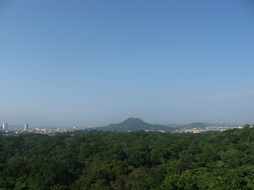
Panoramic viewpoints from Cerro
Cedro (about 155m / 511 ft elevation) overlooking Panama City skyline,
the Canal, Casco Antiguo, Cinta Costera, Bridge of the Americas, and
more.
Well-marked trails through dense forest with opportunities to
spot wildlife like sloths, monkeys, toucans, parrots, iguanas, and the
whooping motmot.
Jicotea Lagoon (seasonal), butterfly house, and
educational areas.
It's ideal for hiking, birdwatching,
photography, families, and a quick nature immersion (2–4 hours typically
suffices, or half a day for deeper exploration).
Opening Hours
and Fees
Hours: Daily 7:00 a.m. to 4:30 p.m. (including holidays).
Some hiking club access earlier. Last entry aligns with closing.
Entrance Fees (paid at Visitor Center; for ages 3+):
Non-nationals
(foreigners/tourists): ~$5 USD adults, $3 children (under 17).
Panamanian citizens/residents: Lower rates (~$1–2 adults, $1 children).
Guided tours or special activities (e.g., night tours, canopy crane)
may have extra fees — check on-site or via the official site.
Getting There
The park is very accessible from central Panama City
(near 15–30 minutes by car/taxi from areas like Cinta Costera).
Taxi/Uber: Easiest and recommended.
Public bus: Routes like
Allbrook–Bahía A; use the MiBus app. Stops are nearby.
Car: Parking
available at the main entrance/Visitor Center (Av. Juan Pablo II area).
Address reference: Near Panama City, close to other sites like Mi
Pueblito or Panama Viejo.
Best Time to Visit
Year-round
access, but dry season (December–May) is preferable: Less rain/mud, more
visible wildlife as trees shed leaves.
Early morning (opening time)
or late afternoon: Cooler, better wildlife activity (birds/monkeys
active), fewer crowds, ideal light for photos. Avoid midday
heat/humidity.
Rainy season (May–Nov) brings lush greenery but
afternoon showers and mud; trails remain open but prepare accordingly.
What to Bring and Wear
Essentials: Water (stay hydrated in
heat/humidity), insect repellent (strong, DEET-based), sunscreen, hat,
binoculars, camera/phone, rain jacket/poncho (even dry season),
comfortable hiking shoes (closed-toe, grippy), light/neutral-colored
long pants + shirt for bug/sun protection.
Snacks/light lunch (no
full restaurants inside; options nearby).
Cash for fees.
Optional:
Trekking poles for stability, field guide/app for birds/plants,
first-aid basics.
Clothing: Breathable, lightweight, modest for
trails. Avoid bright colors if wanting to blend for wildlife spotting.
Wildlife and Nature Tips
Spotting tips: Move quietly, scan canopy
for sloths/monkeys, listen for birds. Early/late visits maximize
chances. Patience and binoculars help.
Respect wildlife: Don't feed,
touch, or get too close. Stay on trails.
Educational value: Visitor
Center may have displays; guided tours or self-guided with apps/maps.
Safety and Regulations
General safety: Low risk inside the park
during open hours, but standard precautions apply (urban proximity).
Don't visit after dark; stick to marked paths.
Health: High
heat/humidity — hydrate, watch for heat exhaustion. Mosquitoes
(repellent, possible dengue risk). No major hazards if prepared.
Rules: Follow park regulations — no littering, no removing
plants/animals, no loud music, appropriate dress. Check official site
for full list.
Panama City has petty crime; secure valuables (leave
non-essentials at hotel).
Additional Experiences
Guided tours
(highly recommended for deeper insights).
Canopy crane (if available)
for elevated views.
Butterfly house, educational programs, rentals
for events.
Combine with nearby sites: Panama Canal views, Casco
Viejo, Biomuseo, or Cinta Costera.
Practical Advice for Your
Visit
Time needed: 2–4 hours for main highlights; longer for
birding/photography.
Accessibility: Some easy/paved trails; not fully
wheelchair-friendly on most paths.
For families/kids: Easy trails,
lagoon, play areas — engaging and educational.
Photographers:
Viewpoints at sunrise/sunset magic; macro for insects/plants.
Website: parquemetropolitano.org for latest maps, events, fees.
Practical Information
Location: Near Avenida Juan Pablo II,
accessible from Albrook or central Panama City (short taxi/metro + walk
or Uber).
Hours: Generally 7:00 a.m. to 4:30 p.m. (hiking club
members earlier). Best to arrive early for wildlife, fewer crowds, and
cooler temps.
Entrance Fee: ~$4 USD for foreigners/adults (lower for
residents/children); pay at the Visitor Center. Maps available. Guided
options exist for better wildlife spotting.
Facilities: Visitor
center, restrooms, some benches/shelters, picnic areas. Bring water,
insect repellent, comfortable shoes, light clothes, snacks, and rain
gear (tropical climate, humid, possible showers).
Wildlife: Common
sightings include agoutis (ñeques), coatis, Geoffrey’s tamarin monkeys
(mono titi), howler monkeys, sloths (less common), turtles, leaf-cutter
ants, colorful birds, butterflies, and more. Stay quiet and observant.
Tips: Trails total ~8 km if combining most. Wear sturdy shoes (some
stairs/roots). No vehicles on most paths. Early morning or clockwise
loops recommended for solitude and animals.
There are about seven
main trails, mostly short and interconnecting, allowing flexible loops.
Here are detailed descriptions based on reliable sources.
1.
Sendero El Roble (Oak Trail)
Length: Under 1 km (~0.6 miles).
Difficulty: Easy/flat.
Time: ~15 minutes.
Highlights: Connects to
other trails; features a small pond/lagoon with many slider turtles
(often mistaken for logs). Some WWII aircraft remnants visible. Pleasant
forested section, good for beginners or as a connector.
2.
Sendero La Cienaguita (and connection to Mono Titi)
Length: Part of a
popular ~1.45 km loop when combined.
Difficulty: Moderate (some
ups/downs).
Time: 20–30 minutes uphill.
Highlights: Starts with
moderate climb; WWII plane engine parts in the jungle (historical
testing ground). Good birdwatching and agouti sightings. Leads to Cerro
Cedro summit with excellent skyline views of Panama City’s skyscrapers.
Combine with Mono Titi for a loop (clockwise suggested for fewer
people).
3. Sendero Mono Titi (Tamarin Monkey Trail)
Length:
Wide path, part of the main loop (hundreds of meters to viewpoint).
Difficulty: Moderate (can be steep in sections).
Time: Variable;
downhill from summit ~30–45 minutes.
Highlights: Formerly an internal
road; wide and accessible. Leads to Cerro Cedro viewpoints (benches
available). Covered wooden Los Trinos lookout midway. Excellent for
spotting tamarin monkeys in treetops, coatis, leaf-cutter ants, and
birds. Ends near a large concrete bunker ("El Castillo," 1974 aircraft
facility, now jungle-overgrown). Popular but rewarding.
4.
Sendero Los Caobos (Mahogany Trail)
Length: ~0.9 km (0.56 miles).
Difficulty: Moderate to difficult (many stairs, elevation).
Time:
~30–45 minutes.
Highlights: Loop trail with majestic Honduran
mahogany (Swietenia macrophylla) trees. Steep stair sections (up then
down), semi-flat areas, and a viewpoint with city/forest vistas. Quieter
than the main loop. Offers beautiful forest immersion and bird/dragonfly
sightings. Under maintenance in some older reports—check conditions.
5. Sendero Los Momótides (Motmot Trail)
Length: Short loop
(~0.5–1 km estimated).
Difficulty: Easy to moderate.
Time: ~15
minutes.
Highlights: Across the road from the main visitor area.
Pretty forest section with butterflies, beetles, and birds (motmots
possible but not guaranteed). Often the quietest trail. Good quick
option or add-on.
6. Sendero Dorothy Wilson
Length: ~300
meters.
Difficulty: Easy (paved, handrails, accessible).
Time: Few
minutes.
Highlights: Designed for reduced mobility (including Braille
signs). Informative panels on plants/animals, picnic spots. Short wooded
stroll near the visitor center.
7. Sendero Los Guayacanes
Length: ~70 meters.
Difficulty: Very easy.
Time: A few minutes.
Highlights: Connects Dorothy Wilson to El Roble. Open meadow, guayacan
trees, flower garden with butterflies. Minimal shade in parts but very
accessible.
Pre-Columbian and Colonial Era
The site's deep history reflects
Panama's rich indigenous and colonial past. During the pre-Columbian
period, the broader isthmus region (including areas near modern Panama
City) was inhabited by indigenous groups with sophisticated societies,
such as those associated with the Isthmo-Colombian cultural sphere.
These societies featured chiefdoms, advanced agriculture (including
ridged fields), goldworking, ceramics, and complex burial practices.
While specific archaeological details for the exact park grounds are
limited in public records, the area would have been part of the forested
landscapes used by these peoples for hunting, gathering, and possibly
settlement.
In the colonial era (following Spanish arrival in the
early 16th century with explorers like Rodrigo de Bastidas, Christopher
Columbus, and Vasco Núñez de Balboa), the site of what is now the park
would have appeared as dense tropical forest near key transit routes
linked to the Panama Canal area. It was part of the broader landscape
shaped by Spanish colonial activities, including trade routes across the
isthmus. Remnants or traces of this period, such as potential pathways
or resource use, contribute to the park's "footprints from our past"
narrative promoted by its official management.
20th Century:
Military Use and Early Conservation Ideas
The modern history of the
park is closely tied to the Panama Canal Zone. The area was administered
or influenced by the United States for much of the 20th century. It was
reportedly designated or used as a military zone during World War II,
likely for training, testing (including possible early jet engine or
aircraft-related facilities like structures nicknamed "El Castillo"), or
other defense purposes in the Canal Zone.
By the 1970s, amid growing
urbanization and recognition of the area's ecological value near the
canal, conservation efforts began. In 1974, initial steps were taken in
land-use plans for the Canal Area to optimize and protect the site. In
1975, then-President Jorge Illueca (who later became a key figure in its
protection) toured the area, leading to a formal proposal for a
metropolitan natural park.
In 1983, the area was declared the Curundú
Recreational Area, marking an interim step toward formal protection.
Official Establishment (1985–1988)
The park was officially
created by Law No. 8 of July 5, 1985, under Panamanian legislation. It
was inaugurated on June 5, 1988. This establishment reflected Panama's
commitment to conservation amid rapid urban growth and the transition of
Canal Zone lands. Strong legal protections, supported by figures like
Jorge Illueca (who died in 2012), helped it resist development pressures
from surrounding avenues, housing, and malls.
The park's creation
preserved a remnant of Pacific tropical dry forest (covering about 75%
of the area), an ecosystem that has largely disappeared elsewhere in the
country, along with transitional and humid forest elements.
Late
20th Century: Historical Events and Military Legacy
The park's
location in the former Canal Zone placed it near significant historical
events. It was the site of activity during the 1989 U.S. invasion of
Panama (Operation Just Cause) to oust General Manuel Noriega. Concrete
structures and remnants from earlier U.S. military use (training areas,
etc.) remain visible or noted in the park.
Post-invasion and with the
full transfer of Canal Zone authority to Panama by the end of the 20th
century, the park transitioned fully into a public recreational and
conservation area managed under Panama's environmental authorities (now
the Ministerio de Ambiente).
Modern Era and Significance
Today, the park is managed as a protected natural area emphasizing
education, recreation, and biodiversity conservation. It features hiking
trails, a canopy observation tower with panoramic views of the city, and
rich flora (around 284 plant species, including tall trees, vines,
epiphytes, orchids, and mosses) and fauna (227 bird species, 45 mammals,
36 snakes, 14 amphibians, plus monkeys, coatis, squirrels, etc.).
It
serves as an urban oasis for hiking, birdwatching, environmental
education (with programs for schools), and research. Official resources
highlight its "footprints from our past," connecting pre-Columbian,
colonial, military, and conservation histories. It remains a symbol of
balancing urban development with nature preservation in Latin America.
Location and Boundaries
The park sits in the corregimiento of Ancón,
Distrito de Panamá, on the Pacific side of the isthmus. It lies north of
downtown Panama City, roughly a 10-15 minute drive from the city center,
bordered by:
Western and northern sides: Camino de la Amistad
(Friendship Road).
Southern and eastern sides: Corredor Norte
highway.
Internal division: Avenida Juan Pablo II runs through or
alongside parts of the park.
It occupies a strategic position on
the eastern bank of the Panama Canal's Pacific terminus. Together with
nearby protected areas like Parque Nacional Camino de Cruces and Parque
Nacional Soberanía, it forms part of a biological corridor along the
canal's watershed, helping maintain water flow for the canal and
supporting regional biodiversity.
Coordinates: Approximately 8.991°N
79.546°W.
Size and Topography
The park spans 232–265 hectares
(about 573–655 acres), a compact but ecologically significant urban
green space.
Elevation:
Minimum: ~5 m (near lower areas or river
influence).
Maximum: ~123 m (at viewpoints like Cerro Cedro or the
main mirador).
Average: ~42 m.
The terrain is hilly and
rugged, with moderate to steep inclines. Trails feature an elevation
gain of around 912 ft (~278 m) for a full loop (e.g., ~2.7 miles / 4.3
km hike). The highest points offer panoramic views of Panama City’s
skyline, Panama Bay, islands, the Amador Causeway, and even the
Miraflores Locks on the Panama Canal.
The park's hills and valleys
create varied microhabitats, with the Río Curundú running along the
eastern side, supporting aquatic life like fish and shrimp.
Geology and Soils
As part of the Panamanian transisthmian region, the
park lies in an area shaped by tectonic activity related to the
formation of the Isthmus of Panama. Soils are typical of tropical
areas—often well-drained but susceptible to erosion on slopes. The
underlying geology supports a mix of forest types adapted to the local
conditions. Specific detailed geological surveys emphasize its role in
the broader canal watershed hydrology.
Climate
The park
experiences a tropical savanna/monsoon climate with distinct wet and dry
seasons. It is notably drier than Caribbean-side forests.
Dry
season (roughly December–April): Limited rainfall (~140 mm on average),
leading to deciduous behavior in many trees.
Wet season
(May–November): Heavy rains, high humidity, and lush growth.
Marked
seasonal variations in humidity, solar radiation, wind, and temperature.
This climate supports a tropical dry forest (Pacific type)
ecosystem, rare in Panama due to development pressures. About 75% of the
park consists of this semideciduous forest, where many trees lose leaves
in the dry season to conserve water.
Flora
The park protects
one of the last significant remnants of Central American Pacific
tropical dry forest. It hosts ~284 plant species, including:
Numerous
trees.
Lianas (creepers/vines).
Epiphytes.
Orchids.
Mosses.
Ferns and mushrooms (with dedicated guides available).
Common
features include dense canopy in wetter periods, with trails winding
through varied vegetation layers—from understory shrubs to tall
emergents.
Hydrology and Landscape Features
The Río Curundú
influences the eastern edge, contributing to riparian habitats. Trails
lead to features like small lagoons (e.g., La Cienaguita) and
viewpoints. The varied terrain includes valleys, ridges, and slopes that
enhance biodiversity by creating moisture gradients.
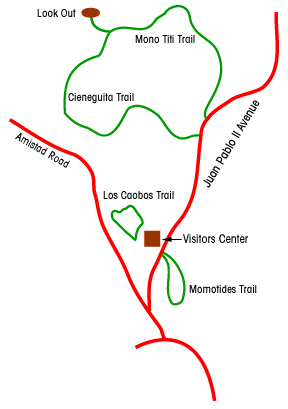
Main Trails
(well-marked, suitable for hiking; visitor center provides maps):
Mono Titi Trail (Titi Monkey Trail): Popular, moderate, connects to
loops.
Dorothy Wilson Trail, Los Momótides, Guayacanes, El Roble, Los
Caobos, La Cienaguita, and others.
Many form loops; the climb to the
mirador is a highlight.