Location: 30 km (19 mi) Northeast of Oriental, Puebla Map
Open: Tue- Sun
Official Site
Cantona (also known as the Cantona Archaeological Zone or Zona
Arqueológica de Cantona) is one of Mexico’s largest and most
impressive yet under-visited pre-Hispanic sites. Located in the
municipality of Tepeyahualco de Hidalgo, Puebla—near the Veracruz
border on a rugged malpaís (lava field) at 2,450–2,600 meters
elevation—it sprawls across roughly 12 km² (with the southern sector
alone covering about 5 km²). The name derives from the Nahuatl
Caltonal, meaning “House of the Sun.”
At its peak (roughly
600–1000 CE), Cantona was a heavily fortified, highly urbanized
trading powerhouse controlling obsidian routes between the Gulf
Coast and Central Highlands. It supported an estimated
90,000–100,000 inhabitants across thousands of residential units.
The city featured advanced planning: defensive walls, an elaborate
road network, an elevated acropolis for elites, and more ball courts
(24–27 discovered) than any other Mesoamerican site. Structures were
built entirely of stacked volcanic rock without mortar or stucco,
creating a stark, functional aesthetic adapted to the uneven lava
terrain.
1. The Road Network and Cobblestone Streets
(Including “First Avenue”)
Cantona’s urban planning stands out
for its extensive system of over 500 cobblestone causeways (some
sources cite up to 4,000 interconnected streets total). These narrow
paths—often wide enough for just two people—follow the lava field’s
topography and were designed for control and defense. Many are lined
with low stone walls.
A standout is the so-called “First Avenue,”
a restored 563-meter (1,850-foot) straight causeway that intersects
other streets and links residential patios, plazas, pyramids, and
ball courts. Two larger prehispanic roads (over a kilometer long)
are framed by high volcanic-stone walls, with some sections
featuring defensive moats. Walking these today gives a powerful
sense of the city’s scale and regimented layout.
2.
Residential Patios and Units
Over 3,000 individual patios
(typically 50×40 meters or larger) and an estimated 7,500–8,000
total residential units once housed the population. In the southern
zone alone, archaeologists have mapped at least 2,700 walled
compounds. Each patio sits on raised plinths or platforms of
volcanic rock, originally supporting thatched-roof houses. Elite
units included workshops, while commoner areas were simpler.
A
good example is Patio 2: an excavated residential complex for 15–20
people on an elevated platform, complete with a nearby
civic-ceremonial structure and a tomb. Perimeter walls enclosed each
unit for privacy and defense. These give insight into daily life in
a densely packed, hierarchical city.
3. The Acropolis
Perched on the highest ground, the Acropolis served as the elite and
religious heart of Cantona. It contained temples for major deities,
priestly residences, and multiple ceremonial buildings. From lower
areas (especially Ball Court 5), you get sweeping views of its
western side—stone platforms rising above the surrounding lava
field.
This elevated stronghold underscored the city’s
militarized and theocratic power, especially in later phases when
military authority increased.
4. Ceremonial Plazas
Dozens
of closed plazas functioned as civic and religious hubs. They are
typically delimited on three sides by sidewalks or superimposed
platforms and anchored on the fourth by a pyramid or altar. The
Great Plaza is the largest overall, while the Earth Fertilization
Plaza (or Plaza de la Fertilidad de la Tierra) stands out for its
agricultural and ritual focus. Offerings, human sacrifices, and nine
phallic sculptures (now in the site museum) were found here, linking
the plaza to fertility rites.
5. Pyramids and Temples
Fourteen pyramids have been excavated—generally smaller and more
numerous than at sites like Teotihuacan. Built of fitted volcanic
stones (with white quarry stone for steps and limestone accents for
ceremonial areas), they rise in stepped tiers without mortar. Many
form part of integrated complexes with ball courts and plazas.
Pirámide del Mirador (Mirador Pyramid) / Plaza Oriente (Eastern
Plaza): One of the most visited. Climb its steps for panoramic views
over the entire southern city, streets, and surrounding landscape.
It anchors the Eastern Plaza and highlights Cantona’s strategic
placement for oversight.
6. Ball Courts (The Signature
Landmark)
Cantona’s 24–27 ball courts (only six fully restored
and open) are its most famous feature—far more than any other
Mesoamerican city. They symbolize ritual power, with evidence of
violent pelota games and sacrifices (decapitated remains found
behind some markers). Courts have sloped stone walls and vary in
orientation, possibly aligned with solar paths.
Twelve follow the
unique “Cantona type” design: an integrated architectural complex
including a central court, one or two plazas, a pyramid, an altar,
and peripheral structures. Asymmetry in walls, orientation, and
dimensions is deliberate.
Ball Court 5 Complex: Offers direct
views of the western Acropolis; a perfect vantage for understanding
the city’s vertical hierarchy.
Ball Court 7 (Pelota Field No. 7):
Features a midfield stele and is one of the best-preserved, with
clear sloped playing surfaces and surrounding structures.
Additional Features and Practical Context
State Workshops: Over
350 official obsidian workshops (sourced from the nearby Zaragoza
mine) highlight Cantona’s economic engine.
Western
Access/Entrance: A 14-meter-tall structure with 47 steep steps
leading to overlooks of western civic-ceremonial areas.
Site
Museum: Free with entry; displays pottery, jewelry, tools, and the
phallic sculptures from the Earth Fertilization Plaza.
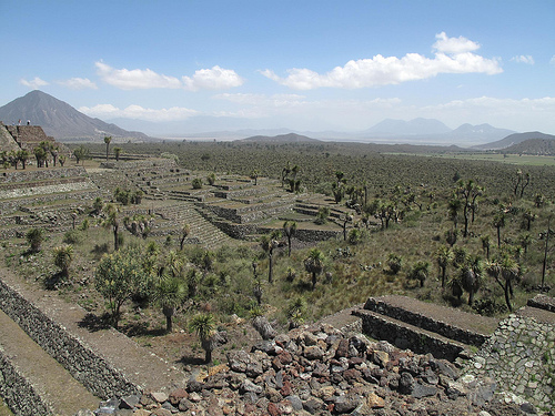
The
southern zone—where all the above landmarks are concentrated—is
fully open and walkable (allow 1.5–2 hours at a leisurely pace,
including pyramid climbs). The site feels vast, quiet, and
atmospheric, with yucca trees and distant mountains framing the
stone ruins.
Discovery and Excavation
European awareness began
in 1855 when Swiss explorer Henri de Saussure documented the site after
an extensive search. Early 20th-century visitors like Nicolás León
provided descriptions of structures and artifacts, while architect Paul
Gendrop (1938) dramatically overestimated its extent (claiming nearly 20
km long). In 1958, archaeologist Eduardo Noguera analyzed ceramics and
building techniques, initially dating it to the Preclassic (200–100
BCE). Systematic work accelerated in the 1980s when Diana López de
Molina used aerial photography for mapping and test pits, followed by
major INAH (National Institute of Anthropology and History) projects
under Ángel García Cook. These focused on the southern civic-ceremonial
core, revealing workshops, ball courts, and housing. Ongoing INAH
fieldwork continues, but the site's immense size means most remains
buried under soil, vegetation, and rock. A small site museum displays
pottery, obsidian tools, jewelry, and ritual objects.
Chronology
and Phases of Occupation
Cantona's history spans nearly 2,000 years
(ca. 1000 BCE–1050 CE), longer than any other major Mexican
civilization. Scholars divide it into phases based on ceramics,
architecture, and settlement patterns:
Pre-Cantona (ca.
1000/900–600 BCE): Sparse villages settled by migrants from the
Puebla-Tlaxcala Valley, Tehuacán Valley, and Gulf Coast. Early obsidian
quarrying from the nearby Oyameles-Zaragoza deposits (just 9–10 km away)
began. By 750–600 BCE, small clusters of joined housing and paths
emerged.
Cantona I (600 BCE–50 CE): Explosive urban growth fueled by
obsidian trade. The city expanded to ~822 acres (3.3 km²) with defensive
walls, raised platforms, elite-controlled silos and workshops, and the
first ceremonial centers. Sixteen ball courts appeared, alongside
evidence of long-distance trade southward.
Cantona II (50–600 CE):
Peak construction and social complexity; cultural height often placed
here or overlapping 350 BCE–550 CE. The city grew to ~2,718 acres;
population reached ~64,000 by 400 CE. Twenty ball courts integrated into
plaza-pyramid complexes.
Cantona III (600–900/950 CE):
Post-Teotihuacan boom. Military elites supplanted priestly authority.
Population peaked at ~90,000 (with ~7,500–8,000 housing units), making
Cantona the dominant city on the Central Plateau. Fortifications
intensified, and state obsidian production scaled up.
Cantona IV
(900/950–1050 CE): Rapid collapse. Population plummeted to 3,000–5,000;
the site was fully abandoned by ~1050–1100 CE.
Economy, Society,
and Trade
Cantona thrived as a trade hub and obsidian powerhouse.
Artifacts from the Zaragoza-Oyameles sources—used for tools, weapons,
and ritual bloodletting—were mass-produced in over 350 state-controlled
workshops in some sectors and exchanged for Gulf Coast goods (possibly
including pulque from maguey). Agriculture supported the population
(maize and other crops), but the arid lava field posed challenges.
Society was strictly hierarchical: elites occupied the southern
acropolis and terraced housing; commoners lived in walled patios below.
Narrow, high-walled streets (some only wide enough for two people
abreast) suggest both defense and social control.
Architecture
and Urban Planning
The city’s design is exceptionally sophisticated
and defensive. Over 500 cobblestone causeways (some >500 m long) snake
across the lava terrain, connecting districts, plazas (often three-sided
with a pyramid on the fourth), and an elaborate acropolis with temples.
Residential units are enclosed by thick stone walls on plinths or
terraces. No mortar was used—stones interlock precisely. The southern
excavated zone (about 70 acres, <2% of the total) showcases restored
features like the Great Plaza, Ball Court 5 and 7 complexes, and elite
housing.
Cultural and Religious Life
Cantona’s 27 ball courts
(six restored in the south) are its most distinctive feature—far
exceeding any other site and symbolizing ritual-political power. Many
follow a unique “Cantona type” layout with adjacent plazas, altars, and
pyramids; evidence of human sacrifice (e.g., decapitated remains)
appears at some. The Earth Fertility Plaza stands out for phallic
sculptures and agricultural offerings. Rituals shifted in later phases
from priestly effigies and sculpture to military emphasis, though ball
games and fertility rites persisted. Origins may trace to Olmec or
Popoloca groups, with possible later Olmec-Xicalanca influences.
Rise, Peak, and Relations with Other Centers
Cantona rose through
obsidian monopoly and trade control during the Preclassic and Classic
periods. It coexisted with—but showed little direct interaction
with—Teotihuacan (~200 km west), apparently benefiting from that city’s
decline around 550 CE by dominating highland-coastal routes in the
Epiclassic power vacuum. It became a fortified regional powerhouse while
smaller states competed for trade.
Decline and Abandonment
Around 900–1000 CE, population crashed rapidly. Paleolimnological
evidence from Lake Aljojuca (20 miles south) reveals a 650-year interval
of frequent droughts (ca. 500–1150 CE) within a long-term arid trend.
This stressed maize agriculture near the northern limit of viable
rain-fed farming, altering the subsistence base. Combined with political
upheaval and possible Chichimec incursions, the droughts contributed
decisively to abandonment by ~1050 CE—though the city had already
outlasted most contemporaries.
Significance and Modern Context
Cantona represents the pinnacle of urban planning and trade control in
central Mexico’s Epiclassic era. Its longevity, scale, and ball-court
density make it exceptional. Forgotten after abandonment (centuries
before Spanish contact), it is now an INAH-protected archaeological zone
open to visitors Tuesday–Saturday (admission ~85 pesos). The restored
southern sector, site museum, and panoramic views from pyramid tops
reveal a sophisticated, self-sufficient society adapted to a harsh
volcanic environment. Though under-visited compared to Teotihuacan or
Cholula, it offers one of Mexico’s most immersive glimpses into
pre-Hispanic urban life.
How to Get There
Cantona is remote with limited
public transport, so planning is key:
From Puebla City (most common
base): About 1.5–2 hours northeast by car via the highway toward
Perote/Xalapa. Many visitors rent a car or join a guided day tour
(recommended for ease, as it includes transport, a knowledgeable guide,
and often stops at nearby spots like Laguna de Alchichica).
Public
transport option: Take a bus from Puebla's CAPU terminal to Oriental or
Tepeyahualco (around 1.5–2 hours), then a local taxi or combi (shared
van) the remaining ~10–20 minutes to the site entrance. This works but
can be tricky for return trips—arrange a pickup or taxi in advance.
From Mexico City: Around 3–3.5 hours east via bus to Tepeyahualco area,
then local transport.
Driving tip: The access road is paved but
rural; follow signs for "Zona Arqueológica Cantona." GPS works well.
Best Time to Visit
Season: Year-round is possible, but aim for
the dry season (October–April) to avoid heavy rain or mud on the rocky
paths. Winters (December–February) can be windy and chilly at
altitude—bring layers.
Time of day: Early morning (site opens ~9:00
AM) for cooler temperatures, better light for photos, and fewer (if any)
crowds. Avoid midday in warmer months (April–June) due to intense sun
and heat. The site closes around 6:00 PM.
Crowds: It's almost always
quiet—sometimes you'll have the place to yourself, unlike Teotihuacán or
Chichén Itzá.
Entrance and Practical Info
Hours:
Tuesday–Sunday, 9:00 AM–6:00 PM (closed Mondays).
Admission — Around
$105 MXN for Mexican nationals, $210 MXN for foreigners (prices can
fluctuate; includes the small on-site museum). Free on Sundays for
Mexican nationals with ID.
Facilities: Basic—restrooms at the
entrance, a small site museum with artifacts and explanations (some
English signage/tablets). No food, drinks, or shops on-site. No pets
allowed, no food/drink entry in some areas, no smoking.
Duration:
Plan 3–5 hours to explore properly (a full loop can take 4+ hours with
hiking). The terrain involves uneven stone paths, stairs, and climbing
some structures (where allowed—stick to marked areas).
Essential
Travel Tips
What to wear/bring:
Comfortable walking/hiking shoes
or boots—essential due to rocky, uneven volcanic stone paths, stairs,
and potential dust/mud.
Sun protection: Hat/cap, sunglasses, high-SPF
sunscreen (high altitude + open exposure = strong UV).
Layers: Windy
and cooler than Puebla; a light jacket or sweater is smart, especially
in winter.
Hydration and snacks: Bring plenty of water (at least 1–2
liters per person) and packed lunch/snacks—nothing is sold on-site, and
the nearest options are limited roadside spots.
Guiding: Highly
recommended—hire a local guide at the entrance (supports the community)
or book a tour from Puebla. The site has signage, but a guide explains
the layout, ball game significance, trade route role, and hidden
details.
Safety and etiquette: Stay on marked paths—some areas are
unstable. Respect the site—no climbing restricted structures, no
littering. Cell signal is spotty or nonexistent.
Combine visits: Pair
with nearby attractions like the stunning blue Laguna de Alchichica
crater lake (on the way), Perote area, or even a longer route to
Xalapa/Veracruz sites.
Accessibility: Not very wheelchair-friendly
due to rough terrain and stairs—best for those with good mobility.