Location: 125 km (78 mi) Northeast of San Cristobalck, Chiapas Map
Cascadas de Agua Azul (Blue Water
Waterfalls) is a spectacular series of cascades and natural pools along
the Xanil River (also referred to locally as the Agua Azul or Yaxhá
River) in the municipality of Tumbalá, Chiapas, southern Mexico. The
site lies at coordinates 17°15′21″N 92°06′57″W, approximately 69 km (43
mi) southeast of the Maya archaeological site of Palenque and easily
accessed via Mexican Federal Highway 199. It sits in the northeastern
part of Chiapas, within the Northern Mountains physiographic region and
near the western edge of the Lacandon Jungle (Selva Lacandona).
This
location places it in a transitional zone between the Chiapas Highlands
to the south (where the river originates) and the lower Gulf coastal
plain to the north. The surrounding terrain belongs to a broader karstic
limestone plateau carved by rivers draining toward the Gulf of Mexico.
Topography and Elevation
The Cascadas de Agua Azul occupy a rugged
but relatively low-relief landscape of low hills, forested canyons, and
gentle slopes. The average elevation at the main cascade area is
approximately 250 meters (820 feet) above sea level, with moderate
topographic relief shown in contour maps (typical gains of around 70–80
meters / 240 feet along short trails). The river descends stepwise
through shallow canyons and vertical limestone cliffs, creating a series
of terraces rather than a single high drop. Upstream, the Xanil River
rises in higher Chiapas Highlands; downstream, it flows into broader
valleys. The protected zone encompasses varied terrain supporting both
lowland rainforest and pockets of pine-oak forest at slightly higher
elevations.
Hydrology: River System and Waterfalls
The Xanil
River is roughly 30 km long and forms part of the larger Grijalva River
basin. Its full watercourse is: Agua Azul (Xanil) River → Río Shumuljá
(or Shumula) → Río Tulijá → Río Chilapa → Río Grijalva (ultimately
reaching the Gulf of Mexico). Tributaries such as the Otulún and
Shumuljá contribute upstream, feeding the system.
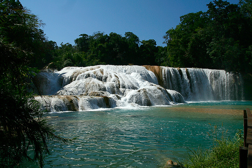
The waterfalls
themselves extend over approximately 6 km, comprising hundreds of small
cascades (up to 500 individual drops) with individual falls typically
2–6 meters (6–20 ft) high—the longest around 6 m. The river often
divides into two parallel streams separated by small vegetated islands.
Between the drops lie calm natural pools (albercas) perfect for
swimming. In some descriptions, the river emerges from a cave system,
forming a natural 30-meter bridge before the initial sequence of five
small waterfalls. Flow varies seasonally: higher volume and turbidity
during the rainy season (May–October), clearer and more vividly colored
in the dry season (especially April–May).
Geology and Formation
Processes
The site exemplifies karst topography developed on
sedimentary limestone bedrock. The river water is supersaturated with
calcium carbonate and other minerals dissolved from the upstream
limestone highlands. As the water cascades, CO2 degasses (or is consumed
by aquatic plants and algae), causing rapid precipitation of calcium
carbonate. This builds successive rimstone dams (also called
gours)—natural limestone barriers that create the characteristic stepped
terraces, shallow pools, and small waterfalls.
These dams encrust
rocks, fallen trees, and vegetation in thick, shell-like limestone
coatings (travertine/tufa deposits). Trees can be seen in various stages
of calcification. The vivid turquoise-blue color results from the high
mineral content scattering light (most intense in low-flow, clear-water
conditions). The entire 6 km section of rimstone features is unique to
this stretch of the Xanil River; upstream and downstream segments lack
the same intense deposition. The underlying geology also includes cave
formation and underground drainage typical of karst systems.
Climate
The area experiences a tropical rainforest climate (Köppen
Af/Am), hot and humid year-round with average temperatures of 25–30°C
(77–86°F). Annual rainfall is high (often exceeding 2,000–3,000 mm),
concentrated in the wet season from May to October, which swells the
river and can reduce water clarity. The dry season (November–April)
brings lower flows but exceptionally clear, mineral-rich turquoise
waters—ideal for viewing the geological features. High humidity and
consistent warmth support the dense vegetation.
Surrounding
Environment and Conservation
Dense tropical rainforest dominates the
immediate surroundings, with tall canopy trees, epiphytes, and lush
undergrowth. The protected area also includes elements of pine-oak
forest on slightly higher slopes. The site forms part of the
ecologically rich Chiapas jungle corridor, near the Lacandon Jungle
biosphere reserves. The entire zone was designated the Agua Azul
Waterfall Protection Area (Área de Protección de Flora y Fauna Cascadas
de Agua Azul) in 2000 by the Mexican government. It spans 2,580 hectares
(25.8 km²) and safeguards the waterfalls, river, limestone formations,
and associated rainforest.
The rugged “Mountains of Water” landscape
(as locally known) features numerous additional rivers, rapids, and
pools in the vicinity. Note that the 2017 Chiapas earthquake temporarily
reduced flow via a crack in the system, but the site has since
recovered.
Best Time to Visit
The optimal time is during the dry season, from
November to April/May (with November–February often highlighted as
ideal). In this period:
The water flow is calmer, revealing the
signature bright turquoise and clear pools.
Swimming is safer and
more enjoyable.
Weather is hot and humid but with less rain risk.
Avoid the rainy season (June–October) if you want the iconic blue
color—rain increases sediment, turning the water brownish and muddy, and
can make currents stronger or hide hazards. Swimming may be unsafe then
due to debris and powerful flows. However, the falls are more voluminous
during rains if you're okay with altered colors.
Aim to arrive early
(around 9 AM) for fewer crowds, better light for photos, and more
wildlife sightings (like monkeys in the trees).
How to Get There
The waterfalls are about 60 km (roughly 90 minutes by road) from
Palenque, the most convenient base. From San Cristóbal de las Casas,
it's farther—around 160 km (4+ hours), making it a long day.
Options:
Organized tours (recommended for most visitors): Many full-day tours
from Palenque combine Agua Azul with Misol-Ha waterfall (and often
Palenque ruins). From San Cristóbal, tours exist but are longer (12–18+
hours, sometimes starting very early). Look for reputable operators via
platforms like Viator or GetYourGuide—prices vary but often include
transport, guide, and some entrances (around $50–$100+ USD depending on
group/private).
Independent travel: From Palenque, take a colectivo
(shared van) from near the ADO bus station or main road—they depart when
full. Cost is low (around 100–200 MXN round-trip). Arrange return times
carefully, as schedules are flexible. Driving yourself is possible but
note potential road conditions and safety considerations in Chiapas.
From other areas: Less practical without a tour.
The road is
generally straightforward via Highway 199, but check current conditions.
Entrance Fees and Practical Costs
As of recent reports
(2024–2025):
Official entrance fee: Around 40–120 MXN per person
(roughly $2–$6 USD), though some mention multiple small fees (e.g., road
tax + entry).
Additional costs: Parking if driving, optional local
guide for farther trails (around 50 MXN), food/snacks from on-site
vendors.
The site includes a 2 km trail along the river with
access to many pools.
What to Expect and Do
Swimming: Popular
in calmer, designated pools—refreshing in the heat. Stick to marked safe
areas; avoid spots with signs (some have strong currents, undercurrents,
or hazards like submerged logs/rocks—nicknamed areas like "the
liquidizer").
Hiking/Exploring: Walk the trails for different
viewpoints, including upper cascades. Some go farther to spots like La
Boquilla (may need a local guide).
Other activities: Photography
(stunning from multiple angles), birdwatching, relaxing at natural
pools, or visiting handicraft stalls and restaurants near the entrance.
Facilities: Restrooms, changing areas, food vendors (local cuisine like
empanadas or grilled items), handicrafts, and limited camping/cabins.
Plan 2–3 hours on-site for a relaxed visit.
What to Bring
Swimsuit, quick-dry towel, and water shoes (rocks can be
slippery/sharp).
Sunscreen, hat, insect repellent (jungle setting,
humid).
Reusable water bottle, snacks (vendors available but
limited).
Dry bag for valuables if swimming.
Cash (small bills in
MXN for fees, food, transport).
Camera/phone for photos—the colors
pop best in good light.
Safety Tips
The site itself is
generally safe for tourists, but heed warnings:
Swimming hazards:
Currents can be deceptive—only swim where locals/guides do, and
supervise kids.
Jungle environment: Watch for slippery paths,
insects, and wildlife.
Regional context: Chiapas has some travel
advisories (exercise caution due to crime in parts of Mexico). Tourist
areas like Palenque, Agua Azul, and main routes are typically fine, but
avoid night driving, rural backroads, or hitchhiking. Stay updated via
official sources (e.g., government travel advisories). Use reputable
transport/tours, and don't flash valuables.