Location: Coba, 44 km North- West of Tulum, Quintana Roo Map
Coba is one of the most expansive and atmospheric ancient Maya
archaeological sites in the Yucatán Peninsula, located in Quintana
Roo, Mexico, about 47 km northwest of Tulum. Surrounded by dense
jungle and two large freshwater lagoons (Lake Cobá to the southwest
and Lake Macanxoc to the east), the site spans an estimated 80 km²,
though only a small portion has been excavated and restored by
Mexico’s National Institute of Anthropology and History (INAH). At
its peak during the Late Classic period (roughly 600–900 CE), Coba
was a powerful city-state with a population possibly exceeding
50,000, controlling trade routes, farmlands, and alliances as far as
central Mexico (evidenced by Teotihuacan-style architecture).
What sets Coba apart from better-known sites like Chichén Itzá or
Tulum is its vast scale and unique network of sacbeob (white roads),
the largest in the Maya world. Only three main architectural groups
are open to visitors—Grupo Cobá, Nohoch Mul, Conjunto de Pinturas,
and Macanxoc—linked by these ancient causeways. The site also
features numerous stelae (carved stone monuments), ball courts, and
a round observatory. Much of Coba remains jungle-covered, giving it
an explorer-like feel. Note that climbing the main pyramid has been
prohibited since 2020 for safety and preservation reasons.
Preclassic and Early Classic Origins (c. 50 BC–600 AD)
Archaeological evidence shows Cobá was first settled between 50 BC
and 100 AD. Early inhabitants lived in a modest town of wooden and
palm-thatched structures on flat platforms, supported by agriculture
and hunting/gathering around the lakes. Pottery fragments provide
the main surviving evidence from this era.
Population and
influence grew rapidly after 100 AD. By 201–601 AD, Cobá had become
a dominant city-state controlling vast territories across northern
Quintana Roo and eastern Yucatán. Its power stemmed from fertile
farmlands, strategic trade routes (including Caribbean ports like
Xel Há), and reliable freshwater lakes—critical in the Yucatán’s
karst landscape. It forged alliances with major southern Maya
centers such as Tikal (Guatemala), Dzibanché, and Calakmul
(Campeche) through military pacts and elite marriages. Influences
from central Mexico appear too: a platform in the Las Pinturas group
shows Teotihuacan-style architecture, explored in 1999.
Stelae
(carved stone monuments) indicate several female rulers (Ajaw) held
power, highlighting relatively prominent roles for women in Cobá’s
governance compared to some other Maya cities. A sizable
agricultural population already occupied the area by the 1st century
AD.
Late Classic Peak (c. 600–900 AD)
Cobá reached its
zenith during the Late Classic period, with most major construction
occurring between 500 and 900 AD and the bulk of dated hieroglyphic
inscriptions from the 7th century. At its height, the city housed an
estimated 50,000 inhabitants (possibly far more), spread across
roughly 80 km² (31 sq mi). It functioned as a regional capital and
one of the most powerful polities in the northern Yucatán.
Key
features from this era include:
The largest network of Maya
sacbeob (white roads) in the ancient world—over 50 raised causeways
linking ceremonial, administrative, and residential zones, some
extending dozens of kilometers to satellite sites like Yaxuná.
The Nohoch Mul (“Great Mound”) group, featuring the tallest pyramid
on the Yucatán Peninsula: Ixmoja (Structure D-1), rising 42 meters
(138 ft) with 120 steps.
Numerous engraved stelae recording
rulers, ceremonies, and events. Inscriptions name at least 14
leaders between roughly 500 and 780 AD, including a queen named
Yopaat.
Recent discoveries have refined this picture. A
massive stela (over 36 feet long), dubbed the “Rock of the
Foundation,” was uncovered in 2024. Its glyphs detail the founding
of the settlement Keh Witz Nal (“Deer Mountain”) on May 12, 569 AD,
and name a previously unknown ruler, K’awiil Ch’ak Chéen (who
adopted the name of the god K’awiil, linked to fertility and
storms). Epigraphers also identified Queen Ix Ch’ak Ch’een, a
6th-century female ruler, underscoring women’s leadership roles
during this formative dynasty.
Cobá maintained strong ties with
southern Maya powers and controlled extensive territory through its
roads and alliances.
Terminal Classic Decline and Power
Struggle (c. 900–1000 AD)
Around 600–900 AD, emerging Puuc-region
cities and especially Chichén Itzá began challenging Cobá’s
supremacy. A prolonged power struggle ensued, with Cobá losing
control of key sites like Yaxuná. By 900–1000 AD, Chichén Itzá had
eclipsed it politically. Cobá’s dominance waned as trade routes
shifted toward the coast, though it retained some symbolic and
religious prestige.
Postclassic Continuity and Abandonment
(c. 1000–1550 AD)
Cobá never fully collapsed. New construction
continued in the Eastern Coastal architectural style between 1200
and 1500 AD, and older structures were maintained. It remained a
viable settlement into the 14th century—longer than many
contemporaries—and was still occupied when the Spanish arrived
around 1550. The city was gradually abandoned amid the broader
disruptions of the conquest era.
Modern Rediscovery and
Archaeological Exploration (19th–20th Centuries)
The dense jungle
and the Caste War of Yucatán (1847–1901) kept Cobá isolated for
centuries. The first printed mention came in 1842 from explorer John
Lloyd Stephens, who heard reports but deemed a visit too difficult.
In 1882, Juan Peón Contreras (director of the Yucatán Museum) made
the arduous journey and produced the earliest known sketches.
Teoberto Maler visited briefly in 1893 and took photographs.
Serious documentation began in 1926 when amateur explorer Thomas
Gann reached the site with local Maya guides and published the first
detailed eyewitness account. That year, Carnegie Institution of
Washington archaeologists (including Alfred Kidder and J. Eric S.
Thompson) conducted expeditions, uncovering major stelae and the
Macanxoc Group. Thompson returned multiple times through 1932,
publishing a comprehensive report. Minor excavations followed, such
as H.B. Roberts’ trenches in 1932 and visits by William and Michael
Coe in 1948.
Systematic Excavation and Tourism Development
(1970s–Present)
The site remained largely inaccessible until the
early 1970s, when plans for Cancún tourism prompted development. The
Mexican National Institute of Anthropology and History (INAH)
launched excavations in 1972 under Carlos Navarrete, clearing and
consolidating structures like El Cono and Las Pinturas. The formal
“Project Cobá” (1974 onward) mapped dozens more sacbeob (adding 26
to the previous 19 known), excavated key groups, studied ceramics,
and surveyed transects. A new road opened in 1975, followed by paved
access in the 1980s and regular bus service.
Cobá officially
opened to the public in 1973. Today only a fraction of the estimated
6,000 structures has been cleared; the rest remains under jungle.
Tourism drives the local economy—the nearby pueblo had about 1,278
residents in 2010—and the site drew over 700,000 visitors in 2017
alone. INAH continues conservation, and Cobá is one of the few Maya
cities still known by its ancient name.
Recent milestones include
the 2024 discovery and ongoing conservation of the massive founding
stela, which has added new rulers and refined the city’s early
dynastic history. In December 2025, after five years of restoration,
the iconic Nohoch Mul (Ixmoja) pyramid reopened for climbing via a
new eco-friendly wooden staircase, allowing visitors to experience
the panoramic views once again.
The Sacbeob (White Roads)
These elevated limestone causeways are
Coba’s most distinctive feature—over 50 have been identified, with
at least 16 accessible to visitors today. Constructed with stone
sides, rubble fill, and a white plaster or limestone surface (hence
“white roads”), they range from 2–10 meters wide and were used for
ceremonial processions, trade, administration, and connecting the
city to distant settlements. The longest runs over 100 km west to
Yaxuná. The widest sacbe leads to the Macanxoc Group and passes
stelae and altars. Today, these shaded, straight paths (some lined
with trees) serve as walkways or bike trails for visitors, evoking
the scale of the ancient city.
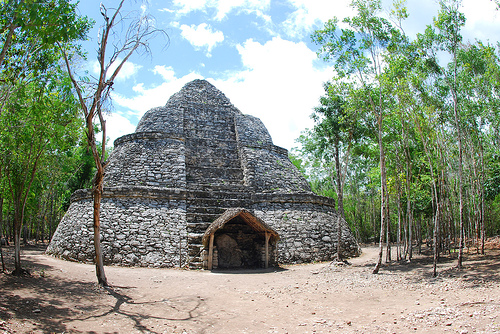
Grupo Cobá (Cobá Group) and La
Iglesia (“The Church”)
Near the entrance, this is the oldest and
most important group, situated on the shore of the lagoons. It
contains over 50 structures, including patios, vaulted rooms,
shrines, a large plaza, and one of the site’s two ball courts. The
standout landmark is La Iglesia, a 24-meter-high pyramid
(second-tallest at the site) with steep steps and a thatched-roof
temple on top. A carved stela (Stela 11) stands at its base. This
group highlights Coba’s early development and central role in the
city’s layout.
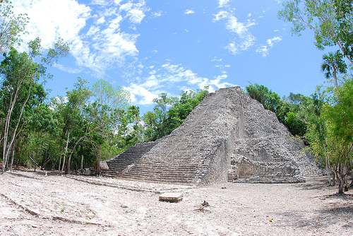
Nohoch Mul Pyramid (Ixmoja – “Great Mound”)
The undisputed icon of Coba, this is the tallest pyramid on the
Yucatán Peninsula at 42 meters (138 ft), with a seven-tiered base,
rounded corners, and a temple at the summit (featuring diving-god
motifs in some descriptions). Located in the Nohoch Mul Group, it
was the departure point for the great sacbe to Yaxuná. From the top
(when climbing was allowed), visitors once enjoyed panoramic views
over the jungle canopy and both lagoons. Its lower section dates to
the Late Classic period, with a later Post-Classic addition on
top—showing architectural evolution. The surrounding group has only
a few explored structures, but they are among the largest by volume
at the site.
Conjunto de Pinturas (Paintings Group)
This
spiritual and ceremonial area features the Pyramid of the Painted
Lintel, where faint original Maya paintings remain visible on the
upper temple from a distance. The group includes a platform with
architectural influences from Teotihuacan (central Mexico),
underscoring Coba’s far-reaching connections. It lies along a sacbe
after the Cobá Group and adds a layer of artistic and religious
depth to the site.
Macanxoc Group and the Stelae
Reached
via the widest sacbe (passing additional stelae and altars), this
group sits on a raised platform (1–4 meters high) near Lake
Macanxoc. It contains at least eight intricately carved stelae and
numerous altars, making it a key area for understanding Coba’s
history. The stelae (over 30 exist site-wide) feature hieroglyphic
inscriptions in the Long Count calendar, depictions of rulers
(including powerful women like Lady Yopaat), rituals, prisoners, and
major events from the 7th–9th centuries. They provide rare insights
into Maya sociopolitical life, gender roles, and Coba’s dominance
before its decline.
Ball Courts and Other Features
Coba
has two ball courts (one prominently in the Cobá Group). These
I-shaped arenas hosted the ritual Mesoamerican ball game,
symbolizing cosmic struggles. A round observatory (mentioned in
official descriptions) and additional structures like the Castillo
(possibly referring to a main-group pyramid) add to the ceremonial
landscape. The two lagoons were vital for water control and likely
held sacred significance.
Best Time to Visit
The ideal window is during the dry season,
roughly December to April, when rain is minimal and temperatures are
more bearable (though still warm/humid). Avoid peak summer (May–October)
if possible due to intense heat, humidity, and afternoon showers.
Within the day, arrive right at opening (around 8:00 AM) to beat crowds,
tour groups, and midday heat. Crowds pick up by late morning/early
afternoon. Late afternoon (after ~2–3 PM) can work for fewer people but
leaves less time before closing (typically 5:00 PM, last entry ~4:00
PM). Avoid Sundays if possible, as Mexican nationals/residents often get
free or discounted entry, increasing local crowds.
How to Get
There
Coba is in Quintana Roo, inland from the Riviera Maya coast.
From Tulum: ~45–60 minutes by car (easiest base for a day trip).
From Playa del Carmen: ~1.5–2 hours.
From Cancun: ~2–2.5 hours.
From Valladolid: ~45–60 minutes.
Best options:
Rent a car —
Most flexible and recommended. Drive independently, arrive early, and
control your pace. Parking at the site costs ~60 MXN (~$3 USD).
Colectivo/shared van or ADO bus — From Tulum or Playa del Carmen
(cheaper but less convenient; may require transfers).
Organized tour
— From Riviera Maya resorts/hotels (often combines Coba with cenotes or
other sites; convenient but less freedom and more crowded).
Taxi/private driver — Comfortable but pricier.
The site is
well-signposted off the main roads, but drive cautiously—jungle roads
can have topes (speed bumps) and occasional wildlife.
Practical
Info: Tickets, Hours, and Getting Around
Opening hours: Daily ~8:00
AM–5:00 PM (last entry often 4:00 PM; confirm on-site or official
sources as hours can shift slightly).
Entrance fee: Around 220–330
MXN (~$11–17 USD) for foreign tourists (recent increases;
nationals/residents pay less). Bring cash (pesos preferred; some spots
may not take cards).
Additional costs:
Parking: ~60 MXN.
Bike
rental: ~50–80 MXN (highly recommended—the site is huge, spanning
several km).
Bike taxi (tricycle/Maya taxi): ~100+ MXN for a guided
ride.
Time needed: 2–4 hours minimum for main highlights; 4–6
hours to explore thoroughly without rushing.
The ruins are spread
out, so choose your transport:
Bikes → Best for independence and fun;
pedal along shaded paths.
Walk → Free but tiring (1–2+ miles just to
the main pyramid).
Bike taxi → Good if hot or with mobility needs.
A new staircase was added in late 2025, allowing climbing of Nohoch
Mul again (after years of restrictions)—follow any posted safety rules.
Essential Tips for a Great Visit
Beat heat/crowds — Early arrival
is key; bring plenty of water (refill stations limited), wear
lightweight/breathable clothes, sturdy closed-toe shoes (no flip-flops
for climbing), hat, sunscreen, insect repellent.
Cash is king — Bring
pesos for entry, parking, bikes, snacks, tips.
Pack light but smart —
Snacks/lunch (limited on-site options), reusable water bottle,
camera/binoculars for wildlife.
Respect the site — Stay on paths, no
touching/climbing except designated areas, no drones.
Combine wisely
— Pair with a cenote swim or nearby Punta Laguna (spider monkeys) for a
full day. Avoid cramming too much (e.g., Coba + Tulum + another site)
unless driving early.
Health/safety — Jungle means bugs/mosquitoes;
stay hydrated. Site is generally safe, but watch belongings.