Location: Chihuahua Map
The Copper Canyon or the Copper Canyon is called the system
consisting of seven ravines. Located in the Sierra Tarahumara in the
southwest of the Mexican state of Chihuahua in Mexico. The canyon
system is four times larger in extension (60,000 km²) and almost
twice as deep as the
Grand
Canyon of Colorado river in Arizona, in the United States of
America. It is home to the indigenous Rarámuris or Tarahumaras.
Copper Canyon gets its name from a green color walls that look like
a copper, thus the name. It is a popular destination for many nature
lovers. You can explore Copper Canyon by hiking, camping, biking,
driving and even take a local horse on a ride through the region.
The Copper Canyon (as they are called locally) are crossed by
the Chihuahua to the Pacific train route, known as "el Chepe". In
the section Divisadero-Los Mochis, the train goes into the mountain
to cross the rugged geography, passes cliffs precipitous, crosses 86
impressive short and long tunnels, and 37 spectacular bridges that
plow rivers. This is an important transportation system and a
tourist attraction. Today it can be reached by road from the city of
Chihuahua, approximately in five hours, and penetrate the ravines
through rural roads. Flying over them in a helicopter offers a
spectacular aerial view.
Geological Formation
The geological story of Copper
Canyon is relatively young compared to older canyon systems like the
Grand Canyon. The underlying rocks consist primarily of explosive
volcanic ash flows (ignimbrites), ash falls, and mudflow breccias
deposited during intense volcanic activity in the Sierra Madre
Occidental province approximately 20–40 million years ago (Oligocene to
Miocene epochs). With the exception of some older basement rocks at the
very bottom of the deepest gorges, the entire landscape is built on this
volcanic plateau. Over subsequent millions of years, six major
rivers—fed by rainfall and snowmelt from the high Sierra
Tarahumara—eroded downward through the volcanic rock, creating the
intricate canyon network we see today. This erosion process continues,
shaped by the region’s steep topography and seasonal flows.
The
result is a vertical world of cliffs, plateaus, and subtropical
microclimates at the canyon floors contrasting with cooler pine forests
above—conditions that have profoundly influenced human history here.
Indigenous Inhabitation: The Rarámuri (Tarahumara)
Archaeological
evidence indicates human presence in the region for over 2,000 years,
but the dominant and enduring inhabitants are the Rarámuri (self-name
meaning “those who run fast” or “the running people”; outsiders know
them as Tarahumara). Numbering today between 35,000 and 70,000
(estimates vary, with no official census), they have called these
canyons home for centuries, with documented continuity for at least 400
years.
The rugged terrain provided natural protection, allowing the
Rarámuri to maintain a high degree of autonomy and cultural continuity.
They practice a semi-nomadic lifestyle with seasonal migrations:
retreating to cooler highland pine forests in summer and descending into
the warmer canyon floors in winter. Traditional dwellings include caves,
simple wooden structures, and small milpa plots where they grow corn,
beans, and squash using sustainable ancient techniques, supplemented by
hunting, fishing, and gathering.
Their legendary endurance
running—used historically for hunting, messaging across vast distances,
and the traditional game rarajipari (kicking a wooden ball over
marathon-like canyon routes)—remains central to their identity. Women’s
colorful multi-layered skirts and embroidered blouses, along with men’s
white tunics, headbands, and woven belts, reflect deep artistic
traditions; they are also skilled basket-weavers and woodcarvers.
Spiritual life blends indigenous beliefs with Catholicism, evident in
syncretic festivals like Semana Santa featuring dances, rituals, and
communal gatherings.
Spanish Colonial Period (16th–18th
Centuries)
European contact began in the 16th century during the
Spanish conquest, with intensified exploration in the 17th century as
New Spain sought gold and silver. Jesuits arrived to evangelize,
establishing missions and introducing Christianity, livestock, and new
crops. Silver deposits led to mining operations; the town of Batopilas
was founded around 1632 deep in a canyon as a silver-mining center. Some
Rarámuri were enslaved or displaced from fertile lands, prompting small
uprisings that had limited success. Many Rarámuri retreated deeper into
the canyons, preserving their independence at the cost of isolation.
Despite pressures, they selectively adopted elements of Spanish culture
while resisting full assimilation.
The Ferrocarril Chihuahua al
Pacífico (“El Chepe”): A 20th-Century Engineering Epic
The modern era
truly opened with the railroad. The idea of a line connecting
Chihuahua’s interior to the Pacific port of Topolobampo (near Los
Mochis) dates to 1880, when President Manuel González granted a
concession to American Albert Kinsey Owen for a utopian socialist colony
project. Construction began around 1898–1900 under Arthur Stilwell’s
Kansas City, Mexico and Orient Railway, with early Mexican-led segments
(such as Chihuahua to Minaca) built by the “Chihuahua al Pacífico”
company.
Progress stalled for decades due to the Mexican Revolution
(1910s), chronic funding shortages, and the extraordinarily difficult
terrain of the Sierra Madre. The Mexican government acquired rights in
1940, merged lines in 1955, and took on the final, most challenging
258-kilometer mountain section from Creel to San Pedro (Sinaloa). After
massive investment and heroic engineering—86 tunnels, 37–39 bridges, and
countless cuts through volcanic rock—the line was completed and
inaugurated on November 23–24, 1961, by President Adolfo López Mateos.
The full 653-kilometer route, with its 15-hour journey from Los Mochis
to Chihuahua, remains one of the world’s great rail adventures.
The
Chepe (nickname from “Chihuahua–Pacífico”) transformed the isolated
region, enabling commerce, access for the Rarámuri, and the birth of
tourism while passing iconic viewpoints like Divisadero and dramatic
switchbacks at Témoris.
Modern History, Tourism, and Challenges
(1961–Present)
The railroad’s completion catapulted Copper Canyon
into global prominence. Mexico created Parque Nacional Barranca del
Cobre to protect the area, and towns such as Creel (a tourism hub at
2,350 m elevation), Divisadero, Cerocahui, and Urique grew as gateways.
The annual Copper Canyon Ultra Marathon, inspired by Christopher
McDougall’s 2009 book Born to Run, highlights Rarámuri running prowess
and draws international athletes.
Tourism has brought economic
opportunities—Rarámuri sell crafts and food at train stops and offer
guided experiences—but also tensions. Some communities embrace roads,
lodges, and government support; others resist to safeguard their
isolation and traditions. Environmental pressures are acute: only about
2% of old-growth forest remains due to logging, agriculture, and
grazing; open-pit mining pollutes air and water; dams threaten rivers;
and herbicide spraying for drug crops harms biodiversity (including the
now-extinct-in-the-wild imperial woodpecker and endangered Tarahumara
frog). Climate change and poverty add further strain, though
conservation laws and sustainable tourism initiatives offer hope.
Location and Extent
The system lies in southwestern
Chihuahua state, within the Sierra Tarahumara (a subsection of the
larger Sierra Madre Occidental mountain range). Its approximate
geographic center is at 27°30′58″N 107°45′57″W. The canyons drain the
western slopes of this high plateau and ultimately feed into the Gulf of
California via the Río Fuerte.
The entire complex sprawls across
roughly 65,000 km² (25,000 sq mi)—an area larger than many entire
countries—making it one of the biggest canyon networks in North America.
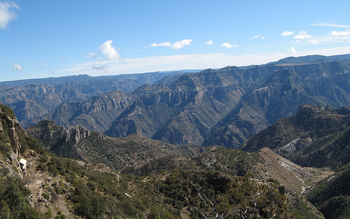
The Canyon System and Major Canyons
Six primary rivers have
carved six major canyons that together form the Barranca del Cobre. The
walls often display a striking copper-green tint from mineral oxidation
and vegetation, which inspired the Spanish name. Depths are impressive:
Urique Canyon (the deepest and most iconic, sometimes called
Barranca del Cobre proper): ~1,870 m (6,136 ft)
Sinforosa Canyon:
~1,800 m (5,904 ft)
Batopilas Canyon: ~1,800 m (5,904 ft)
Copper
Canyon (central section): ~1,760 m (5,770 ft)
Tararecua Canyon:
~1,424 m (4,674 ft)
Oteros Canyon: ~983 m (3,225 ft)
Some
sections exceed the maximum depth of the Grand Canyon, though the Grand
Canyon’s rocks are far older. The combined length of the gorges and the
sheer volume of the system make Copper Canyon unique in scale.
Geological Formation
The canyons are geologically young compared with
many famous gorges. Between roughly 30 and 40 million years ago
(mid-Tertiary period), massive volcanic activity built the Sierra Madre
Occidental—one of the world’s largest silicic volcanic provinces.
Explosive eruptions produced thick sequences (>1,000 m) of ignimbrites
(welded ash-flow tuffs), rhyolites, ash falls, and mudflow breccias
overlying older andesitic lavas.
Tectonic uplift and crustal
fracturing followed, raising the plateau to an average elevation of
~2,275 m (7,500 ft). The relatively soft, fractured volcanic rocks
proved highly susceptible to erosion. Six rivers, originating on the
high Sierra Tarahumara, cut downward through these layers over the
subsequent tens of millions of years, exploiting faults and fractures to
create the present-day canyons.
Unlike the billion-year-old rocks
exposed in the Grand Canyon, Copper Canyon’s visible strata are mostly
20–40 million years old (with some older basement rocks at the deepest
levels).
Topography and Elevation
Elevation changes
dramatically over short horizontal distances. Canyon rims typically sit
at 2,000–2,400 m, while floors drop to 500–600 m in the deepest sections
(e.g., Urique village at 560 m, Batopilas at 600 m). Rim communities
such as Creel (2,350 m) and San Juanito (2,405 m) contrast sharply with
the subtropical depths.
The topography features near-vertical cliffs,
knife-edge ridges, and massive rock walls. Dramatic waterfalls—such as
Cascada Basaseachi (260 m) and Piedra Volada (366 m)—plunge from the
rims, underscoring the vertical relief.
Hydrology and Rivers
Six rivers (including the Río Urique, Batopilas, Candameña, Septentrion,
and others) carved the canyons and continue to shape them. These
westward-flowing streams drain the Sierra Tarahumara, converge into the
Río Fuerte, and ultimately reach the Gulf of California. Some eastward
drainage feeds the Río Conchos and the Río Grande system. Seasonal flash
floods during the summer rains are powerful erosive agents.
Climate
The extreme topography creates sharp climatic gradients.
Higher elevations have an alpine to temperate climate with cool nights
and moderate daytime temperatures (especially pleasant October–November
and March–April). Canyon bottoms are subtropical to tropical—warm and
humid year-round. A pronounced dry season lasts April–June; the summer
monsoon (starting July) brings heavy rains that can trigger landslides
and flash floods.
Vegetation Zones and Geographical Diversity
Elevation-driven microclimates produce distinct vegetation belts:
Upper rims (>2,400 m): pine-oak forests, including Mexican
Douglas-fir
Mid-slopes (1,200–2,400 m): oak woodlands with Andean
alder and poplar
Canyon slopes: scrub and brush
Canyon floors:
lush tropical species—figs, palms, and broadleaf trees—where water and
warmth are abundant.
Wildflowers carpet the upper regions after
the summer rains. This vertical biodiversity is a direct result of the
canyon system’s dramatic relief and varied exposures.