Location: 51 km (32 mi) North- East of Chichen Itza Map
Open: 8am- 5pm
Entrance Fee: USD $4
Ek Balam (meaning “Black Jaguar” or sometimes interpreted as “Star
Jaguar” in Yucatec Maya) is a remarkable yet relatively
under-visited ancient Maya archaeological site in the northern
Yucatán Peninsula, Mexico. Located about 25 km (15 miles) north of
Valladolid and roughly 56 km (35 miles) northeast of Chichén Itzá,
it sits within the municipality of Temozón.
The city flourished
as the capital of the Kingdom of Talol from the Middle Preclassic
period (around 300 BCE) through the Terminal Classic (up to ~1100
CE), reaching its zenith between 770 and 896 CE under rulers like
the powerful k’uhul ajaw (sacred lord) Ukit Kan Le’k Tok’ (who
acceded in 770 CE). At its peak, it spanned about 12 km², with a
densely built ceremonial core protected by walls. Today, visitors
explore a compact excavated zone with around 45 mapped structures
arranged along a north–south axis in two main plazas (South and
North).
Ek Balam stands out for its exceptionally well-preserved
stucco friezes and sculptures (protected for centuries by later Maya
construction), intricate hieroglyphic texts, and the fact that —
unlike many major sites — you can still climb its main pyramid for
sweeping jungle views. The site features northern Petén-style
architecture blended with local innovations, defensive walls, five
sacbeob (sacred white roads), a ballcourt, carved stelae, and three
known murals.
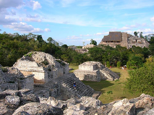
Overall Layout & Defensive Features
The ceremonial core is
enclosed by two concentric defensive stone walls (the inner one carved
and plastered, about 2 m / 6.6 ft tall and 3 m / 9.8 ft wide; the outer
more functional), plus internal walls and a final rubble barrier in the
Great Plaza. These walls end dramatically at a steep sinkhole
(cenote-like feature) and controlled access via five gates linked to
sacbeob. A vaulted passageway (Structure 18) served as the main elite
entrance. The layout symbolizes the Maya four-part cosmos, with
platforms and plazas aligned for ceremonies.
The Entrance Arch
(Arco de Entrada / Structure 18)
Visitors enter through this striking
ceremonial four-legged corbelled arch built over a sacbé. It features
ramps on either side and likely served processional or ritual purposes
rather than purely defensive ones. Passing through frames your first
view of the plazas and jungle beyond — a dramatic gateway to the ancient
capital.
South Plaza Highlights
Oval Palace (Structure 16 /
Palacio Oval)
This distinctive multi-tiered building dominates the
south side of the South Plaza. Built atop a rectangular base but with
rounded, irregular upper levels, it contains about 10 rooms on the lower
tier plus a small crowning temple. Archaeologists believe it had
astronomical or cosmological functions, possibly tied to calendar
ceremonies; burial relics have been found here. You can climb it for
excellent views back toward the towering Acropolis. Its architecture
blends styles and feels more intimate than the massive northern
structures.
Las Gemelas (The Twins / Structure 17)
On the west
side of the South Plaza, two nearly identical temples sit side-by-side
on a single raised platform, each with its own stairway and stucco
masks. This symmetrical “twin” design is unique and adds to the site’s
sense of balanced cosmology.
Platform of the Stelae (Structure
14)
A low platform holding carved stelae (upright stone monuments),
including one possibly depicting ruler Ukit Kan Le’k Tok’. These
monuments record dynastic history and dates.
The Ball Court
Located between the South and North Plazas (dedicated in 841 CE), this
classic Maya juego de pelota features two parallel sloping structures.
Like others across Mesoamerica, it hosted the ritual ball game
(pok-ta-pok) using hips, knees, and elbows — often with high stakes tied
to mythology or sacrifice. Though smaller than Chichén Itzá’s, it is
well-restored and evocative.
The Acropolis (Structure 1 / El
Torre / Royal Palace) — The Star Attraction
The largest and most
spectacular building at Ek Balam (and one of the biggest in
Mesoamerica), the Acropolis anchors the North Plaza. Measuring roughly
162 m long × 68 m wide × 32 m high (about 530 × 223 × 105 ft), it is a
massive six-tiered multi-level complex with rooms, courtyards,
passageways, temples, and elevated plazas. A broad central stairway
ascends from the south; you can climb all 106+ steep steps (wear good
shoes — they’re uneven and can be slippery).
The true masterpiece
lies on the fourth level: the Sak Xok Naah (“White House of the
Counting/Reading”) — a self-contained temple and royal mausoleum. Its
façade is dominated by a gigantic open mouth of the Earth Monster
(sometimes called a jaguar or reptilian deity), complete with massive
curving fangs rising from the ground. This symbolic portal represented
the entrance to the underworld (Xibalba); passing through it granted the
deceased ruler access to the afterlife. The entire stucco façade is
extraordinarily well-preserved (protected by a later Maya wall until
modern excavation), featuring:
Molded masks and geometric motifs.
Hieroglyphic serpents with extended tongues.
Elaborately costumed
winged “angel” figures (actually high-ranking warriors or deities with
feathered wings and regalia) — unique in the Maya world and among the
most detailed stucco sculptures anywhere.
Over 40 painted and carved
texts, including the famous Mural of the 96 Glyphs (a calligraphic
masterpiece in blue, red, and cream recording the ruler’s accession on
April 7, 770 CE and dynastic history).
Inside the chamber lay the
tomb of Ukit Kan Le’k Tok’, accompanied by more than 7,000 offerings
(jade, obsidian, shells, ceramics). The discovery revolutionized our
understanding of northern Maya kingdoms. From the summit, panoramic 360°
views stretch across the Yucatán jungle — often with few other visitors
in sight.
Preclassic Origins and Early Development (c.
700/300 BCE – 300 CE)
Occupation at Ek' Balam began in the Middle
Preclassic period (approximately 700–300 BCE or 300 BCE–300 CE,
depending on ceramic evidence), as confirmed by pottery fragments
and early settlement layers. Initial settlers established a modest
community that grew steadily through the Late Preclassic. Population
expansion and urban development accelerated, transforming the site
into a regional capital around the beginning of the Common Era.
Early constructions laid the foundation for the ceremonial core,
including platforms and plazas that would later expand dramatically.
The site’s strategic location in the cenote-rich Yucatán landscape
supported agriculture and trade, setting the stage for its rise as a
polity controlling surrounding settlements.
A late 16th-century
Spanish colonial document (Relación Geográfica) records a founding
legend attributing the kingdom’s origins to a ruler named Ekʼ Balam
(or Coch Cal Balam), said to have arrived from the East—likely a
mythic or dynastic origin story common in Maya accounts.
Classic Period Rise and Golden Age (c. 600–900 CE, Peak 770–840/896
CE)
Ek' Balam reached its zenith during the Late Classic period,
particularly from 770 to 840 (or up to 896) CE, when it became a
powerful kingdom controlling northeastern Yucatán. At its height,
the site supported an estimated population of 10,000–20,000 people
across a core area of about 12 km² (with only a fraction excavated
today). Most visible architecture dates to this era, including
palaces, temples, defensive walls, ballcourts, and five sacbeob
(raised white limestone causeways) radiating in cardinal
directions—symbolizing a cosmologically ordered four-part universe.
The most prominent ruler was Ukit Kan Lek Tok’ (also spelled Ukit
Kan Le’k Tok or similar translations like “the father of the four
flint fronts”), who acceded to the throne on April 7, 770 CE (Long
Count date 9.16.19.3.12 11 Eb 10 Sotz’). During his roughly 30-year
reign (until c. 797–802 CE), he commissioned the majority of the
monumental Acropolis and elevated Talol to regional dominance,
surpassing nearby powers like Cobá. His successors maintained
influence for at least three generations, with a documented series
of rulers extending to Tz'ihb am Tuun in 841 CE. Glyphic texts
record interactions with other polities, and over 40 painted or
carved inscriptions (including stelae) detail accessions,
dedications, and elite activities.
The kingdom operated as a
militarized fiefdom, extracting labor and resources from subordinate
settlements to build its grand works—the local population alone
could not have sustained the scale of construction. Ek' Balam
exerted cultural influence on emerging sites like early Chichén
Itzá, which adopted its techniques in mural painting, stucco
modeling, and ceramics.
Key structures from this era include:
The Acropolis (Structure 1): The largest building (c. 160 m long, 60
m wide, 32–40 m high), a multi-level royal palace complex with six
superimposed platforms, internal plazas, rooms, courtyards, and
stairways. It fuses multiple Maya architectural styles (Petén,
Chenes, Puuc, and East Coast). Level 4 houses the zoomorphic “Earth
Monster” or jaguar-mouth facade leading to the tomb chamber Sak Xok
Naah (“White House of Reading”), where Ukit Kan Lek Tok’ was buried
with over 7,000 offerings (ceramics, shell objects, etc.). The
interior features the famous Mural of the 96 Glyphs (a calligraphic
masterpiece in three rows of 32 glyphs each, painted in blue, cream,
and red) and vibrant wall paintings of warriors, deities, mythic
beings, celestial bodies, animals, plants, and geometric motifs.
Stucco friezes: Exceptionally preserved, including unique winged
“angel” figures (elaborately costumed human-like beings,
unparalleled in the Maya world) and intricate geometric motifs on
temple facades.
Other features: The Oval Palace (Structure 16),
the “Twins” (Structure 17) with mirrored temples and stucco masks, a
ballcourt dedicated in 841 CE, defensive concentric stone walls
(inner plastered wall ~2 m tall), an entrance arch, and a steam
bath. Stelae platforms and carved monuments further chronicle royal
history.
Ceramic evidence (the Late Yumcab complex,
750–1050/1100 CE) shows continuous occupation and local innovation
in pottery styles.
Terminal Classic Decline and Postclassic
Period (900–1100 CE onward)
After 900 CE, Ek' Balam entered a
Terminal Classic decline, with reduced construction and a steep drop
in activity. By the Postclassic, the population had plummeted to
about 10% of its peak, leading to gradual abandonment of the core,
though the broader area saw low-level occupation persisting until
the Spanish arrival in the 16th century. Some evidence suggests
hasty defensive measures, including a poorly built fourth inner wall
bisecting the Great Plaza and indications of conflict or rapid
desertion. Theories for the broader Maya collapse (overpopulation,
environmental stress) may apply, but the site’s defensive walls and
continued (if diminished) use point to a more gradual regional
transition rather than sudden catastrophe.
Modern Rediscovery
and Excavations
The site was first noted in colonial documents
and visited by French explorer Désiré Charnay in 1886. Systematic
mapping began in the 1980s by archaeologists Bill Ringle and George
Bey III, followed by major INAH (National Institute of Anthropology
and History) excavations starting in 1998 under Leticia Vargas de la
Peña and Víctor Rogerio Castillo Borges. The Acropolis was revealed
from an unexcavated mound, exposing the ruler’s tomb and preserved
stucco/plaster elements. Ceramic studies analyzed over 250,000
sherds, establishing a precise chronology from Middle Preclassic
onward.
Ongoing work (including 2022–2024 projects tied to the
Tren Maya infrastructure) has uncovered further treasures. In Room
85 of the Acropolis east wing, archaeologists found a painted vault
capstone (TB 29) bearing an effigy of the deity K’awiil (associated
with lightning, divine power, and royalty) alongside inscriptions
reinforcing Ukit Kan Lek Tok’’s residence and the site’s historical
narrative. These discoveries continue to illuminate Talol’s
political and religious life.
Historical and Cultural
Significance
Ek' Balam stands out for its artistic
mastery—particularly the survival of stucco sculptures and murals
that provide rare windows into northern Maya Classic society,
rulership ideology, and cosmology. It fills critical gaps in the
archaeological record of northeastern Yucatán and demonstrates how
smaller polities like Talol wielded outsized influence through
military control, elite patronage of the arts, and strategic
alliances. Today, managed by INAH as a public site (open since the
late 1980s/early 1990s), it remains a living testament to Maya
resilience, innovation, and the complex interplay of power, ritual,
and environment in one of Mesoamerica’s great civilizations. Much of
the 12 km² settlement remains unexcavated, promising further
revelations about this “hidden gem” of the Maya world.
Location and Why Visit Ek Balam
Ek Balam (meaning "Black Jaguar"
in Yucatec Maya) was a major Mayan city peaking between 770–840 CE,
covering about 12 km² but with the main excavated area much smaller and
walkable. Key highlights include:
The massive Acropolis (El
Trono) with intricate stucco masks and the tomb of ruler Ukit Kan Le'k
Tok'.
Climbable structures offering panoramic jungle views (unlike
many restricted sites).
A defensive wall, ball court, and oval
palace.
Far fewer crowds, allowing a more peaceful, exploratory vibe.
It's an excellent alternative to busier sites, especially if you
want to climb and feel the history up close.
Best Time to Visit
Optimal months: November to April — milder temperatures (around
25–30°C/77–86°F), lower humidity, and minimal rain. Peak dry season
(December–March) brings perfect weather but slightly more visitors.
Avoid: May–October (hot/humid, with heavy rains June–September;
afternoons often stormy).
Best time of day: Arrive right at opening
(early morning) for cooler temps, fewer people, and better light for
photos. Late afternoon (2–3 hours before closing) offers golden-hour
light and near-empty grounds. Midday gets hottest and busiest (though
still low crowds compared to Chichén Itzá).
The site opens daily
from around 8:00 AM to 5:00 PM (last entry ~4:00 PM). Plan 2–4 hours for
the ruins, plus extra for the cenote.
How to Get There
Ek
Balam sits about 28 km (17 miles) north of Valladolid in Yucatán state.
From Valladolid (easiest base): 30–40 minutes.
Collectivo/shared
taxi: ~70 MXN (~$4 USD) one-way per person. Departs from a spot near the
ADO bus station when full (or pay extra to leave early). Returns until
~5 PM.
Private taxi: Negotiable, around 200–400 MXN round-trip.
Rental car: Simple drive; parking at site ~100 MXN.
From Cancún:
~2–2.5 hours (172 km).
From Playa del Carmen: ~2 hours.
From
Tulum: ~1.75–2 hours (127 km).
From Mérida: ~2.5 hours (202 km east).
Best options:
Rent a car for flexibility (roads are good; fill up
gas beforehand).
Take an ADO bus to Valladolid, then local transport.
Book a guided day tour (many from Cancún/Riviera Maya combine Ek Balam +
cenote + Valladolid; private tours offer more time).
Driving from
Riviera Maya? Use toll roads if available for speed.
Public
transport beyond Valladolid is limited, so Valladolid makes the best hub
(colonial charm, cenotes, and easy access to Chichén Itzá too).
Entrance Fees and Practical Costs (Approximate, 2025–2026)
Ek Balam
ruins: 450–550 MXN (~$25–30 USD) for foreigners (split between federal
INAH + Yucatán state fee). Cash or card sometimes accepted; bring cash
to be safe.
Cenote X-Canché: 170–180 MXN (~$9–10 USD) to swim
(includes bike rental in some packages; zipline/rappelling extra
~100–400 MXN).
No ATM on-site — bring Mexican pesos in cash.
Parking: ~100 MXN if driving.
What to Expect and Do
Enter the
site and explore the central plaza.
Climb Acropolis for views (steep
but rewarding; wear grippy shoes).
See detailed stucco work (some of
the best-preserved in the Maya world).
Walk to Cenote X-Canché (1.5
km dirt path; bike rental included or ~80 MXN; tricycle taxi option).
Swim in the open-air cenote (clear, refreshing; life jackets available).
Optional activities: zipline across, rappel, rope swing.
Relax in
the shade — bring water/snacks.
Expect heat/humidity; the site is
mostly unshaded jungle paths. Crowds are low, but growing in popularity.
Essential Tips for a Great Visit
Clothing and gear: Lightweight,
breathable clothes; sturdy closed-toe walking shoes (uneven terrain,
stairs); hat, sunglasses, reef-safe sunscreen. Swimsuit + quick-dry
towel/change of clothes for the cenote.
Essentials to pack: Plenty of
water (stay hydrated), snacks (limited options on-site), insect
repellent (mosquitoes in jungle), cash, camera/phone.
Health/safety:
Moderate fitness needed for climbing; watch steps (no railings). Use
reef-safe sunscreen near cenote. Site is safe, but standard precautions
apply.
Other advice:
Go early/late to beat heat and crowds.
Combine with Valladolid (colorful town, great food like cochinita
pibil).
If driving, note potential tolls and jungle roads.
Limited
signage — consider a guide (certified ones available) or self-guided
with prior research.
Respect rules: No touching carvings; stay on
paths.