Location: 12 km (7 mi) Southeast of Pozarica, Veracruz Map
Open: 9am- 5pm daily
El Tajín (also spelled El Tajin), a pre-Hispanic city in northern
Veracruz, Mexico, near modern Papantla, stands as one of the most
important archaeological sites of the Epiclassic to early
Postclassic period in Mesoamerica (roughly 800–1200 CE). Designated
a UNESCO World Heritage Site in 1992 under cultural criteria (iii)
and (iv), it exemplifies the artistic, architectural, and
socio-economic developments in the Gulf Coast region after the
decline of Teotihuacan and before the Aztec rise.
The site’s name
derives from the Totonac word for “thunder” or “lightning,”
referring to the Totonac rain/thunder god (or twelve storm deities
called Tajín believed to inhabit the ruins). Modern Totonac people
live nearby and consider the area sacred, though it is uncertain
whether they built the city. It is the premier example of Classic
Veracruz culture, with possible Huastec or early Totonac
associations.
Best Time to Visit
El Tajín sits in a tropical climate zone:
December to April is
ideal—warm (pleasant highs around 75–85°F / 24–29°C), relatively dry,
and comfortable for walking. January often brings "delicious" mild
weather with low humidity.
Avoid March–May if heat-sensitive (it gets
very hot).
June–October brings high humidity, frequent heavy rains,
and potential for muddy paths—though crowds remain low year-round.
The site sees fewer visitors overall than major ruins, but it can
get busier on Mexican holidays, Sundays, or during winter months.
Weekdays (especially early mornings) offer the most peaceful experience.
Getting There
El Tajín is somewhat remote, so plan transport carefully:
Nearest
major hubs:
Poza Rica (about 20–30 minutes away) has a small airport
(PAZ) with limited flights, often from Mexico City.
Veracruz City
(about 3 hours drive north via Highway 180).
Mexico City (5–7 hours
drive via toll roads like 132D to Tuxpan/Poza Rica, then south to
Papantla).
By bus: ADO buses run to Papantla (the closest town,
15–30 minutes from the site) from Mexico City (Terminal del Norte),
Veracruz, or Xalapa. From Papantla, take local colectivos (shared
vans/taxis) or taxis to the site.
By car: Roads can be rough/winding
in places—drive cautiously. Parking is available at the site.
Tours:
Day trips from Veracruz, Xalapa, or even Mexico City are possible
(though long), often including a guide and sometimes the Voladores
performance. Private guides or small-group tours enhance the experience.
Practical Visitor Information
Opening hours — Daily, typically 9:00 AM to 5:00 PM (some sources
note 8:00 AM; confirm on arrival or via INAH).
Admission — Around 90
pesos (recent updates; modest fee, with concessions for
students/seniors/children). Buy tickets on-site or potentially online
via INAH.
Time needed — Plan 2.5–3 hours to explore thoroughly. The
site is spread out but walkable.
What to see:
Pyramid of the
Niches — The iconic structure with its grid of niches.
Multiple
ballcourts (some with reliefs).
South Ballcourt carvings.
On-site
museum (small but informative, with artifacts and context on Totonac
culture).
Guides — Highly recommended, as English signage is
limited. Official guides wait inside the entrance (400–500 pesos/group,
depending on duration). Check their English proficiency if needed. Audio
guides or pre-downloaded info/apps can help.
Rules — Structures are
off-limits—no climbing pyramids or buildings (walk around only). Respect
the site—no touching carvings.
Tips for Your Visit
Arrive right at opening (9 AM) to beat any tour groups (they often
arrive 9:30+), enjoy cooler temps, and have the place nearly to
yourself.
Sun protection is essential: The site is open and sunny.
Wear a hat, sunglasses, sunscreen, and light, breathable clothing.
Comfortable walking shoes are a must (paths are mostly flat but can be
uneven/hot).
Hydration & snacks — Bring plenty of bottled water and
snacks. Vendors sell water/snacks inside, but options are limited—better
to come prepared.
Insect repellent — Jungle surroundings mean
mosquitoes, especially in rainy season.
Combine with nearby
attractions — Don't miss the Voladores de Papantla (famous "flying men"
ritual performance, often at midday near the entrance or in Papantla
town). Papantla itself is a charming pueblo mágico with vanilla-scented
streets, markets, and Totonac culture.
Stay overnight — Base in
Papantla for the best vibe (hotels range from budget to mid-range; more
authentic than industrial Poza Rica). This lets you start early and
relax after exploring.
Safety — The area is generally safe for
tourists, but as anywhere in Mexico, stay aware, avoid flashing
valuables, and use reputable transport.
Early Settlement and Rise (Pre-800 CE)
Human
activity in the region dates back to at least 5600 BCE with nomadic
hunters-gatherers transitioning to sedentary farming. Olmec
influences appeared around 1150 BCE, but the area remained
peripheral until later. Evidence of settlement at El Tajín itself
begins around the 1st century CE, with minor occupation possibly
extending earlier. Monumental construction accelerated after ~600
CE, coinciding with Teotihuacan’s decline, as the city filled a
power vacuum in northeast Mesoamerica.
Recent research (as noted
by UNESCO) indicates the main urban phase was a single continuous
occupation from approximately 800 to 1200 CE, rather than the
previously proposed multiple phases from 100 BCE. Early influences
included Teotihuacan-style pottery and stepped pyramids, while trade
networks brought goods from central Mexico and the Maya region. The
fertile Gulf Coast lowlands supported intensive agriculture (maize,
beans, cacao, vanilla, tobacco), fueling growth. By the 7th–8th
centuries, El Tajín began conquering nearby settlements,
establishing dominance over trade routes from the Cazones to
Tecolutla rivers and into the Puebla highlands.
Peak
Flourishing (800–1200 CE)
At its height (especially 900–1100 CE),
El Tajín was the dominant center in northeast Mesoamerica, with
cultural influence reaching the Gulf Coast, Maya lowlands, and
central Mexican plateau. It controlled key exports like vanilla and
imported luxury goods, functioning as a multicultural hub with
evidence of over 50 ethnic groups. Estimated core population:
15,000–20,000 inhabitants, spread across three main zones (Tajín
proper, Tajín Chico, and the Group of Columns), with satellite
communities in surrounding hills and plains. The city spanned a core
of about 60–240 hectares (depending on definitions), though only
roughly half has been excavated.
The urban layout uniquely
follows the Xicalcoliuhqui (a spiral or stepped-fret motif
resembling a marine shell cross-section), using natural terrain
levels and mirroring surrounding hills for hierarchical access.
Plazas were rectangular in the lower zones and trapezoidal or
fret-shaped higher up. Water came from two streams (Tlahuanapa
Arroyo and another), with a defensive wall to the east.
Architecture is distinctive and unparalleled in Mesoamerica:
elaborate niches, stepped frets (key patterns), cornices, poured
concrete roofs (liquid cement over wooden frames, sometimes 1m thick
with pumice fillers), talud-tablero walls with “flying” cornices,
and multi-story buildings (rare outside Maya areas). Structures used
flagstone, limestone, adobe, and stucco, often painted red, blue, or
with murals. Light-blue paint and windows for ventilation show Maya
influence, while scroll/meander designs and reliefs blend Veracruz,
Maya, and Oaxacan styles.
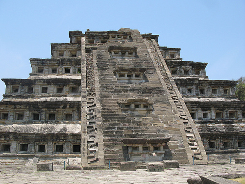
The most iconic structure is the
Pyramid of the Niches (Pirámide de los Nichos), completed around the
8th century CE. This seven-tiered, square-based pyramid (about 20m
high, 35m per side) features 365 deep square niches (symbolizing the
solar year and possibly underworld cave entrances), creating
dramatic light-and-shadow effects. It was originally stucco-covered
and painted red, with a later-added central stairway (flanked by
temples) and an inner earlier pyramid. The niches and astronomical
alignment underscore ritual and calendrical importance.
Seventeen to twenty ballcourts (the highest concentration in
Mesoamerica) highlight the ritual importance of the Mesoamerican
ballgame. These varied in size; the South Ballcourt (198 ft long)
features six carved panels depicting players,
decapitation/sacrifice, skeletal underworld figures rising from
pots, heart extraction, and pulque (fermented agave drink)
rituals—likely tied to fertility, rain, and cosmic renewal. The
North Ballcourt has vertical walls and pulque-god panels. Ballcourts
framed topography and hosted major festivals; rubber balls (sourced
locally) were used. Reliefs narrate myths involving deities,
sacrifice for agricultural bounty, and possible Venus cycles.
Tajín Chico (the “Little Tajín” acropolis on a 7m artificial
platform) served as an elite residential/administrative zone with
palaces, two-story buildings (e.g., Building B), arched entrances,
and richly decorated structures like Building C (stepped frets,
cloud motifs) and the Building of the Columns (with reliefs possibly
depicting ruler 13 Rabbit’s life). The Great Xicalcoliuhqui (a
massive stepped-fret wall enclosing ballcourts) and the Group of
Columns (with column-supported porticos) complete the upper zones.
The Arroyo Group (lowest/oldest) includes early pyramids and a
marketplace plaza.
Religion centered on celestial bodies (Sun,
Moon, Venus), rain/thunder gods, pulque deities, Quetzalcoatl, and
the underworld. The ballgame and sacrifice ensured cosmic balance
and fertility; niches evoked caves to the underworld. Art depicts
cacao rituals, merchant gods, and processions.
Decline and
Abandonment (~1200–1230 CE)
El Tajín was destroyed by fire around
1200–1230 CE, likely from invasion by Chichimec groups from the
north. It was partly abandoned and fell under Aztec
(Mexica-Tenochtitlan) influence shortly after. The Totonacs later
established nearby Papantla. The site was reclaimed by jungle,
though local indigenous knowledge persisted (a village existed at
Spanish contact). Over 500 years of obscurity followed.
Discovery, Excavation, and Modern Era
In 1785, Spanish tobacco
inspector Diego Ruiz “rediscovered” the Pyramid of the Niches while
hunting illegal plantations; his report in the Gaceta de México
sparked interest from scholars like Alexander von Humboldt.
19th-century visitors (e.g., Karl Nebel’s 1836 drawings) documented
it. Early 20th-century explorers included Teobert Maler and the
Spindens.
Systematic work began in the 1930s after oil roads
improved access: Agustín García Vega (1935–1938) mapped and cleared
the Pyramid and 77 acres. José García Payón (1938–1977, INAH)
excavated platforms, ballcourts, and Tajín Chico for decades. Jürgen
K. Brüggemann (1984–1994) uncovered 35 more structures. Additional
ballcourts were found as recently as 2013. A site museum displays
altars, columns, and artifacts. Only about half the site is
excavated; the rest remains under jungle or unprobed.
UNESCO
inscription in 1992 recognized its unique architecture and insights
into the post-Teotihuacan era. Today, it is managed by Mexico’s INAH
under a 2009 management plan emphasizing conservation amid threats
like development, the annual Cumbre Tajín festival (with Voladores
de Papantla performances), tourism (hundreds of thousands of
visitors yearly), and acid rain from nearby oil activity eroding
carvings.
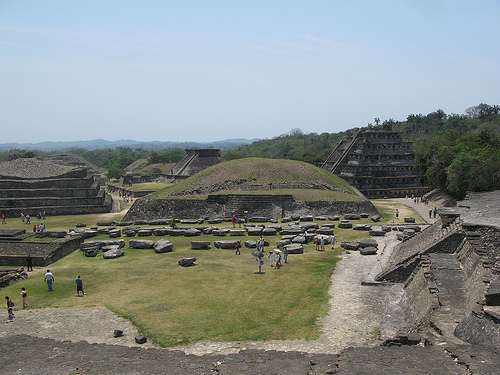
Overall Layout and Urban Planning
El Tajín integrates with its
hilly, tropical environment in the lowlands near the Gulf Coast. The
site spans sections including the main ceremonial center (lower area
with the Pyramid of the Niches and ballcourts), the Arroyo Group, and
Tajín Chico (an elevated northern area for elite palaces and
administrative buildings).
Key features include:
Xicalcoliuhqui motif: The urban layout and a monumental enclosing wall
(Great Xicalcoliuhqui) follow the form of a stylized marine shell
cross-section, a recurring symbolic design. This creates a distinctive
plan unique in Mesoamerica.
Terrain integration: Builders used
natural hills, terraces, and varying elevations to differentiate spaces
(e.g., elite areas higher up) and mirror surrounding hill skylines.
Streams helped define boundaries and supplied water.
Materials and
techniques: Primarily local sandstone (flagstones up to several tons),
packed earth cores, stucco finishes (often painted red with black
accents for contrast), and innovative use of poured cement/concrete
(rare in Mesoamerica, seen in some roofs and structures). Buildings
often overlay earlier phases.
Talud-tablero style (sloping talud
base and vertical tablero panel) shows Teotihuacan influence but is
elaborated with distinctive local elements.
Signature
Architectural Elements
El Tajín's style (sometimes called Classic
Central Veracruz) features elaborate decoration emphasizing texture,
shadow, and symbolism:
Niches: The most iconic feature—recessed
square or rectangular openings in walls and tiers. They create dramatic
light-and-shadow effects, possibly tied to astronomy or cosmology.
Niches appear on many structures, from simple to highly ornate.
Stepped frets (key-patterns or grecques): Interlocking, maze-like motifs
(stepped fretwork) covering friezes, walls, and even buttresses. Common
but used more extensively here than elsewhere.
Flying cornices
("cornisa"): Projecting, overhanging triangular or profiled ledges on
tiers and edges, giving buildings a dynamic, "flying" silhouette and
emphasizing horizontal lines.
Carved reliefs and paintings:
Low-relief carvings on columns, friezes, and panels depict rituals,
ballgame scenes, deities (e.g., Quetzalcoatl), sacrifice, and daily
life. Wall paintings (some colorful) and inset glyphs add narrative
depth. Many originally stuccoed and vividly painted.
Columns and
other details: Ornate columns with reliefs; some evidence of plaster
ceilings or arches in elite buildings.
Pyramid of the Niches
(Edificio 1 or Pirámide de los Nichos)
This is the site's masterpiece
and most famous structure—a six- or seven-tiered (depending on counting)
truncated pyramid, about 18–20+ meters (around 60+ feet) tall on a
square base roughly 35 meters per side.
Key details:
365
niches: Precisely arranged across the tiers (one per day of the solar
year), symbolizing astronomical and calendrical knowledge. Additional
niches on the stairway (later addition) and altars relate to the 18
months of the Mesoamerican calendar.
Construction: Finely fitted
flagstones with minimal mortar, talud-tablero tiers, central staircase
(with platform-altars), and a summit temple (now gone). Niches create
deep shadows; originally painted red (walls) and black (interiors) for
maximum visual impact.
Symbolism: Likely a solar temple or calendar
monument. A smaller pyramid may exist inside. Reliefs and tablets
(including serpent-dragon motifs) adorned parts of it.
It dominates
the central ceremonial area and exemplifies El Tajín's blend of
engineering precision, artistry, and cosmology.
Other Notable
Structures
Ballcourts: Exceptional in number and importance (the
ballgame held ritual significance, often linked to sacrifice and
cosmology). The South Ballcourt stands out with six elaborate bas-relief
panels depicting ballgame scenes, players in ceremonial gear, and
sacrificial rituals. Courts are typically I- or double-T-shaped, often
formed between buildings.
Tajín Chico palaces and buildings: Elevated
elite zone with administrative structures, some with columns (e.g.,
Building of the Columns), murals, and sophisticated layouts aligned for
views over the lower city. Includes Building I and others with unique
features.
Great Xicalcoliuhqui wall: Massive enclosing or defining
wall in the distinctive shell-motif shape.
Other pyramids and groups:
Multiple stepped pyramids (over 40 structures total mentioned in some
counts), temples, and platforms in the Arroyo Group, many with niches,
cornices, and decorative bands.