Location: Tulum Municipality, Quintana Roo Map
Depth: 71.6 meters (235 ft)
Length: 67 kilometers (42 mi)
Nohoch Nah Chich (also known as Sistema Nohoch Nah Chich or "Giant Birdcage/Giant Birdhouse System" in a blend of Spanish and Yucatec Maya) is a vast underwater cave and cenote system in the Yucatán Peninsula of southeastern Mexico. It lies in Tulum Municipality, Quintana Roo, about 16.5 km (10.3 mi) south of Akumal and roughly 8 km inland from the Caribbean coast. The system forms part of the massive Sistema Sac Actun, now the world's longest surveyed underwater cave network.
Geological Origins
The caves originated in the
limestone karst plateau of the Yucatán, shaped over tens of
thousands of years by dissolution of bedrock and collapse creating
sinkholes (cenotes). As an anchialine system, it mixes freshwater
with intruding seawater influenced by tides. During the last Ice
Age, lower sea levels left parts dry, forming unique upward-pointing
formations (halactites). Dye-tracing studies confirm massive
groundwater flow toward nearby coastal lagoons like Caleta Xel-Ha,
though ocean discharge points remain unexplored. The explored
passages extend through dozens of connected cenotes, with depths
reaching up to 119 m (391 ft) in places and extensive shallow zones
ideal for early exploration.
Ancient Maya Cultural Context
Cenotes held profound sacred status for the ancient Maya as portals
to Xibalba (the underworld) and sources of life-giving water. They
served for rituals, ceremonies, and offerings to gods like Chaac
(rain deity). The Yucatec Maya name "Nohoch Nah Chich" reflects deep
cultural familiarity with the landscape, evoking a giant birdhouse
or cage, possibly tied to mythological imagery. However, unlike
prominent sites such as the Sacred Cenote at Chichén Itzá (with
golden artifacts and human remains) or nearby ritual caves like
Balamku, no specific archaeological finds—artifacts, pottery, or
human remains—have been documented or publicized in Nohoch Nah Chich
itself. CEDAM expeditions supported general underwater archaeology
research, but the system lacks reported major discoveries,
distinguishing it from other Yucatán cenotes rich in Maya relics.
Its spiritual legacy endures mainly through the broader cenote
tradition.
Modern Discovery and Exploration (1980s–2000s)
The system's documented history begins in the late 20th century with
pioneering cave divers.
1987: Mike Madden (CEDAM
International Dive Center) founded the CEDAM Cave Diving Team to
drive systematic exploration and research in karst hydrogeology,
water chemistry, microbiology, ecology, and underwater archaeology.
On November 26, 1987, the first dive occurred at the main cenote:
Denny Atkinson, Mike Madden, Juan Jose Tucat, and Ron Winiker laid
2,620 ft (803 m) of guideline on their initial exploration.
1988:
Full exploration and surveying began in summer, marking the system's
entry into the global diving community.
1989–1996: Annual CEDAM
expeditions (led by Madden) brought teams of 2–4 weeks each year.
Divers refined jungle camp techniques, establishing remote bases
like "Far Point Station" (6 km from the coast). Mapping advanced
dramatically; by 1994, cartographer Eric Hutcheson produced an
iconic final map using underwater video footage for the first time,
covering over 38 km (126,000 ft). Named passages (e.g., Charlie’s
line, Ron’s line after Winiker, Bill Carlson line, JJ’s loop after
Tucat) and features like air domes, Heaven’s Gate (massive
stalactite formations), and the "Disneyland" area were documented.
Historical survey map of Sistema Nohoch Nah Chich (with red
exploration lines and labeled cenote entrances/passages),
illustrating the scale achieved through CEDAM efforts in the 1990s —
this became a landmark in cave cartography.
Exploration involved
dozens of divers, including Steve Gerrard (noted photographer), Wes
Skiles, Parker Turner, and many others. Iconic photography and
documentaries (a 1994 Italian cave-diving film with a wooden deck
platform installed, plus a 1995 TV series) highlighted its beauty.
By the 1997 expedition, total passages exceeded 60 km (37 mi).
1990s–early 2000s: Nohoch Nah Chich held the Guinness World
Record for the longest underwater cave system, peaking at 67 km (42
mi) across 36 cenotes. It was renowned for stunning decorations,
shallow clear passages (often <9 m / 30 ft deep), and massive
overhangs.
2006–2007: The breakthrough came when the Sac Actun
Exploration Team (SAET) connected it to the larger Sistema Sac
Actun. Specific connection dives occurred around February 2006 or
precisely on January 25, 2007 (by Steve Bogearts and Robbie
Schmittner). Nohoch's passages were subsumed, extending Sac Actun by
about 14 km and making it the world's longest. The original section
is now officially the "Nohoch Nah Chich Historical section." The
greatest depth in the full system (71.6 m / 235 ft) occurs here at
the "Blue Abyss," first dived in the 1990s by Madden and Bill Main
(initially on air); later pushes in 2010–11 reached deeper zones.
Current Status and Legacy
Today, Nohoch Nah Chich (on private
Rancho San Felipe land) remains a premier advanced cave-diving site,
accessible via guided tours or certified cave divers. A new
recreational cavern line (claimed world's longest) opened in late
2024 for non-cave-certified divers, alongside snorkeling trails
through air domes. It supports ongoing scientific research and
inspires underwater photography and art. While no longer the
standalone record-holder, its "historical section" symbolizes the
golden era of Riviera Maya cave exploration in the 1980s–2000s. The
site's crystal waters, intricate mazes, and ties to Maya cosmology
continue to draw divers seeking both adventure and a connection to
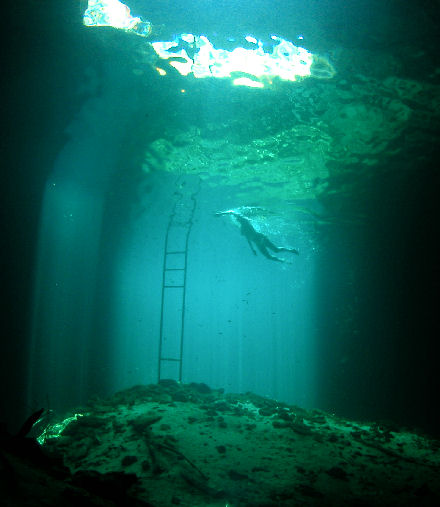
ancient sacred landscapes. Access is via Highway 307, with
facilities like ladders and platforms for safe entry.
Nohoch Nah Chich (Maya for “Giant Birdcage” or “Big House of the
Water”) is a major flooded karst cave subsystem within the larger
Sistema Sac Actun, the world’s longest underwater cave system (currently
surveyed at over 368 km total). It lies in the coastal plain of Quintana
Roo, Mexico, approximately 16.5 km south of Akumal and inland from Tulum
in the Tulum Municipality. The system extends roughly 8 km inland from
the Caribbean coast and connects hydrologically to the sea via coastal
springs (e.g., Cenote Manatí / Tankah / Casa Cenote). It features 36
cenote entrances (collapsed sinkholes) and has a surveyed length of
approximately 67 km with a maximum depth of 71.6 m at the Blue Abyss
shaft.
Regional and Host-Rock Geology
Nohoch Nah Chich
developed in the eogenetic (young, minimally buried) karst of the
Yucatán Platform—a tectonically stable carbonate platform since the
Cretaceous, composed of up to 3,500 m of Mesozoic and Cenozoic
sedimentary rocks. The primary host rock is the Carrillo Puerto
Formation (Miocene to Pliocene), a sequence of shallow-marine limestones
with high primary porosity (typically 5–40%, averaging ~22%). These
overlie older Cenozoic limestones and Chicxulub impact breccias.
Porosity decreases slightly coastward due to diagenesis, but the rock
remains friable and weakly cemented, promoting rapid dissolution and
collapse.
A thin soil cover (skeletal or terra rossa) and tropical
forest overlie the limestone. The platform’s stability, combined with a
regional fracture trend (Holbox fracture zone, NNE-SSW), influences some
passage alignments and linear solution corridors.
Primary
Formation Process: Mixing-Zone (Halocline) Dissolution
The cave
system is a classic example of coastal eogenetic karst formed
predominantly by mixing-zone dissolution. A freshwater lens (meteoric
recharge) floats atop denser saline groundwater from the Caribbean. At
their interface—the halocline or mixing zone—chemical mixing produces
water undersaturated with respect to calcite, aggressively dissolving
the limestone. This is enhanced by:
Tidal pumping and thermal
double-diffusive convection (warmer saline water rises).
Microbial
processes (sulfate reduction and organic-matter oxidation in sediments).
Higher freshwater discharge near the coast.
Unlike small-island
flank-margin caves (limited chambers) or inland telogenetic (mature,
fracture-guided) systems, Quintana Roo caves extend 8–12 km inland
because of high coastal freshwater flux. Passages develop as subparallel
anastomosing networks perpendicular or subparallel to the coast, with
densities up to 4.3 km/km².
Passage Morphology and Key Features
Passages are overwhelmingly horizontal elliptical tubes (1–30+ m wide,
1–5 times wider than high) formed at the halocline level, with smooth to
fretted walls and sediment-mantled floors (clays, breakdown debris,
“boneyard” texture). Canyon-shaped sections and undercuts (1–8.7 m deep)
mark current or paleo-halocline positions; these often lead to collapse
and anastomosis. Multi-level passages occur locally (e.g., Hells Gate).
Collapse is ubiquitous due to weak rock and buoyancy loss in
seawater—producing breakout domes, stepped ceilings, and large breakdown
piles.
Notable Nohoch Nah Chich features include:
Heaven’s
Gate — extensive undercuts at or just above sediment level (not the
modern halocline), thick floor sediments choking lower levels, and
pristine speleothems (indicating limited saline input and freshwater
flushing).
Blue Abyss — a 72 m deep shaft with saline water upstream;
collapse has sealed deeper connections.
Balam Can Chee — saline input
from deep conduits drives active downstream dissolution; >500 m collapse
zones.
Main Line and Hells Gate — classic elliptical tubes with
halocline undercuts.
Multi-Phase Development and Sea-Level
Control
Cave development occurred in multiple phases linked to
Pleistocene glacio-eustatic sea-level fluctuations:
Highstands
(e.g., MIS 5e, ~6 m higher than present) positioned the mixing zone
within existing passages, driving enlargement.
Lowstands (drops of
100–140 m) drained passages, allowing vadose speleothem growth, sediment
infill (calcite rafts, clays), and collapse. Some passages were
abandoned or sealed.
Evidence includes multiple caliche (hardpan)
horizons, drowned speleothems, and ceiling elevation clusters recording
past mixing-zone positions. The last major phase aligns with Holocene
sea-level rise. Inland passages preserve more phases due to platform
accretion.
Modern Hydrogeology
The system is fully phreatic
(water-filled) with a thin freshwater lens (thinning coastward)
overlying saline water and a sharp halocline (visible as a shimmering
layer while diving). Conduits act as high-permeability drains for
regional aquifer flow to the sea; tidal influences and inland
oscillations occur. Porosity is dominated by conduits (hydraulic
conductivity orders of magnitude higher than matrix/fracture). The
aquifer is highly vulnerable to surface contamination.
Scientific
Significance
Nohoch Nah Chich and the encompassing Sac Actun system
serve as a natural laboratory for eogenetic karst processes,
paleoclimate reconstruction (via speleothems and sediments), and
paleoenvironmental studies. They preserve Pleistocene faunal remains and
Holocene archaeological evidence. Exploration since 1987 (CEDAM,
Quintana Roo Speleological Survey) has contributed extensively to
understanding coastal mixing-zone karst worldwide.
Location and How to Get There
Nohoch Nah Chich is located inland
from the Caribbean coast, roughly:
About 8-11 miles (13-18 km)
north of Tulum.
Around 5 km south of the famous Dos Ojos cenote
entrance, along Highway 307 (the main coastal road between Playa del
Carmen and Tulum).
Near the town of Jacinto Pat or along the road
toward Akumal/Playa del Carmen.
Primary access options:
Rented
car — The most flexible and recommended way. Drive Highway 307, then
turn inland on a smaller road (often a dirt/gravel path). It's about
20-40 minutes from Tulum or Playa del Carmen depending on traffic.
Parking is usually available near the entrance. Renting a car in Cancun
(CUN) or Tulum (TQO) airports gives freedom to combine with nearby
sites.
Colectivo (shared van) — Budget option from Playa del Carmen
or Tulum. Get off at a nearby point like Jacinto Pat, then walk ~1.6-2.5
km along a dirt road (bring water, wear good shoes, and watch for
traffic).
Tours/private guide — Many visitors book guided experiences
(snorkel, swim, or dive) from Tulum, Playa del Carmen, or dive shops in
Puerto Aventuras/Akumal. Private guides often cost around $600 MXN (~$30
USD) per person and include transport, entry, and expert narration about
the cenote's history and features. Book in advance for the best
experience.
Taxi or private transfer — Convenient but pricier from
coastal hotels.
Note: It's off the beaten path, so GPS/maps apps
work, but confirm current road conditions as some access involves
unpaved sections.
Best Time to Visit
Year-round accessibility
— Cenotes maintain a constant ~24-26°C (75-79°F) water temperature and
are sheltered, so they're diveable/swimmable any time.
Seasonal
highlights:
Spring (March-May) — Best for light effects (sun beams
piercing the water) and warmer weather, though busier during spring
break.
Winter (Dec-Feb) — Cooler, drier, slightly busier with
tourists, shorter days may reduce dramatic lighting.
Avoid peak
crowds in high season (Dec-April); rainy season (June-Oct) can bring
afternoon showers but fewer people.
Daily timing — Arrive early
(around opening ~8 AM) or late afternoon to avoid crowds. Many visitors
report having it nearly to themselves before 10 AM or after
mid-afternoon. Tour groups often arrive mid-morning.
What to
Expect and Activities
Snorkeling/Swimming — Crystal-clear waters,
light-filled caverns, and jungle vibes. Swim into hidden cave sections;
some areas allow popping up under stalactites.
Diving — Famous for
advanced exploration. Recreational divers can now access the new cavern
line (guided only) with beautiful formations, columns, roots, and fish.
Full cave sections require cave certification and are for experienced
divers only (gothic, mysterious, with narrow passages).
Experience —
Lush jungle surroundings, historical significance (Mayan sacred sites),
and a serene atmosphere. Guides often share stories while you explore.
Entrance fees — Typically $100-400 MXN (~$5-20 USD), varying by
activity (snorkel gear/life jackets sometimes included). Guided tours
add cost but enhance safety and info.
Practical Tips
Bring —
Reef-safe sunscreen (many cenotes ban chemicals to protect ecosystems),
towel, water shoes (rocky/slippery entry), change of clothes, cash (some
spots card-only or limited), bug repellent, snacks, and plenty of water.
Life jackets/snorkel gear often available to rent.
Rules — No
lotions/oils before entering (protect the fragile ecosystem). No
touching formations. Follow guide instructions strictly, especially in
cavern/cave areas (safety lines are key).
Safety — Water is
cool—shock possible if not prepared. Depths vary; stay in open/swimmable
zones unless guided. For diving, use certified operators (e.g., from
Playa del Carmen/Tulum shops).
Combine visits — Pair with nearby
cenotes like Dos Ojos (great for snorkeling), Calavera, or Carwash for a
full day.
Eco considerations — These are natural wonders; leave no
trace, support local guides, and choose sustainable operators.