Location: Chihuahua Map
Open: daily
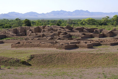
Paquimé (Casas Grandes) is a UNESCO World Heritage Site in
Chihuahua, northern Mexico, representing one of the most significant
archaeological zones in the region. It highlights the
Mogollon/Paquimé culture (roughly 700–1475 AD, peaking in the
14th–15th centuries) as a major trade and cultural hub linking the
Pueblo peoples of the southwestern US, northern Mexico, and
Mesoamerican civilizations to the south.
The site features
impressive multi-story adobe structures (some originally up to 5
stories), T-shaped doors, ballcourts, ceremonial mounds, an aviary
(with evidence of macaw/parrot trade), plazas, and sophisticated
water management systems. Only a portion has been excavated,
preserving much of its mystery and integrity. Adjacent is the
excellent Museo de las Culturas del Norte, which complements the
ruins with artifacts.
This destination suits history,
archaeology, and culture enthusiasts, especially those interested in
pre-Columbian North America. It pairs well with visits to nearby
Mata Ortiz for living pottery traditions inspired by Paquimé
designs.
Best Time to Visit
Ideal seasons: Spring (March–May) and fall
(October–November) offer pleasant temperatures (around 12–27°C /
54–81°F) for exploring outdoors, with clear skies good for photography.
Summer (June–August): Very hot (up to 34–48°C / 93–118°F) and dry, with
strong sun. Visit early morning; bring ample water and sun protection.
Winter: Cool to cold days, with freezing nights. Dress in layers; fewer
crowds.
Check weather forecasts, as the Chihuahuan Desert environment
can be extreme. Monsoon rains occasionally occur in summer.
How
to Get There
By car (recommended for flexibility):
From the US:
Cross at Columbus, NM / Palomas, Chihuahua, then drive south on Mexico
Highway 2 (~2 hours / 123 miles to Nuevo Casas Grandes / Casas Grandes
area).
From Ciudad Juárez (CJS airport): ~196–267 km south, several
hours.
From Chihuahua City (CUU airport): ~267–350 km northwest.
By bus: Futura or other lines to Nuevo Casas Grandes from Chihuahua
(~3.5 hours). Local taxis or arranged transport to the site (8 km from
Casas Grandes).
Tours: Full-day guided tours from Chihuahua often
include Paquimé, the museum, and Mata Ortiz pottery demonstrations.
Convenient for those without a car.
Nearby airports: El Paso (ELP,
US), Ciudad Juárez (CJS), or Chihuahua (CUU). Renting a car provides the
most freedom for exploring the region.
Note: The area is
generally safe and prosperous for tourists, with visitors from the US,
Europe, and Asia. Follow standard precautions: avoid rural roads at
night, use reputable transport, and stay aware.
Visiting the Site
and Museum
Location: Near Casas Grandes, ~8 km from Nuevo Casas
Grandes. The archaeological zone and museum are together at the Paquimé
Cultural Center.
Hours: Typically Tuesday–Sunday, 9:00 AM–5:00 PM
(museum and site). Confirm locally as they can vary.
Tickets/Fees
(approximate; check current rates):
Combined ticket for site +
museum: Around 85–105 MXN for nationals, higher (~210 MXN) for
foreigners. Free on Sundays for Mexican citizens (with ID);
discounts/free for children, students, teachers, seniors.
The ticket
covers both areas.
What to Expect:
Ruins: Self-guided trails
(easy ~2.2-mile loop, ~45–60 minutes). See adobe room blocks, T-doors,
mounds, ballcourt remnants, and an aviary area. Signage explains
features. Wear sturdy, closed-toe shoes for uneven/dusty terrain.
Museum (Museo de las Culturas del Norte): Architecturally stunning,
partially sunken design inspired by the site. Excellent exhibits on
ceramics (highlight), trade goods (shells, turquoise, copper), daily
life, chronology from ancient times, and post-Paquimé history.
Air-conditioned—great on hot days. Includes the Charles Di Peso
collection.
What to Bring and Practical Tips
Essentials: Sun
hat, sunglasses, sunscreen, comfortable walking shoes, reusable water
bottle (hydrate constantly—desert heat), light layers,
camera/binoculars.
Clothing: Breathable natural fabrics in summer;
warm jacket/sweater in winter. Modest dress for cultural respect.
Health/Safety: Bottled water only. Basic first aid, any personal meds.
Watch for snakes (mostly nocturnal), cacti. Pharmacies available in
town. No food inside certain areas; no pets/smoking.
Photography:
Permitted (check rules); golden hour light is beautiful on adobe ruins.
Accessibility: Mostly flat but uneven paths; museum is more accessible.
Not ideal for severe mobility issues.
Cash: Use pesos (MXN); ATMs in
Nuevo Casas Grandes. Cards limited at small sites/shops. Tip 10–15%
where appropriate.
Nearby Attractions and Experiences
Mata
Ortiz: World-renowned pottery village (~20–30 minutes away). Watch
artisans (hand-coiled, mineral paints, open-fire kilns) inspired by
Paquimé. Buy authentic pieces; many workshops welcome visitors.
Other
sites: Cliff dwellings (e.g., Cueva de la Olla), petroglyphs, or further
exploration in the Sierra Madre Occidental foothills.
Town amenities:
Nuevo Casas Grandes/Casas Grandes for meals (local Mexican cuisine),
lodging (e.g., Hotel Hacienda, Durazno Inn), and shops.
Sample
Itinerary (Full Day)
Morning: Arrive, visit ruins (cooler).
Midday: Museum (AC, exhibits).
Afternoon: Mata Ortiz pottery demo +
shopping.
Evening: Relax in town or return.
Early Settlement and the Viejo Period (ca. 700–1130/1200 CE)
The
broader Casas Grandes region shows evidence of human activity for
millennia, but the specific cultural sequence relevant to Paquimé begins
in the Viejo (Old) period. Small settlements of pit houses and early
surface structures appeared, with inhabitants practicing agriculture
(maize, beans, etc.) supported by the fertile river valley.
Recent
research, including work by archaeologists Michael Whalen and Paul
Minnis, has shown continuity rather than a sharp break: Viejo period
remains underlie many Medio period sites, including Paquimé itself.
There was no major "hiatus" or empty niche filled by outsiders; instead,
local populations gradually developed more complex settlements,
ceramics, and architecture.
Rise and Florescence of Paquimé
(Medio Period, ca. 1130/1200–1450 CE)
Settlement at Paquimé
intensified after around 1130 CE, with clusters of single-story adobe
houses around plazas. The site grew dramatically, especially after a
possible burning event around 1340 CE, leading to reconstruction with
multi-story apartment-style buildings (up to 4–7 stories high in
places).
At its peak in the 14th and 15th centuries, Paquimé covered
about 90 acres (with the core zone around 36–146 hectares protected) and
featured over 2,000 rooms in clusters of living spaces, workshops, and
storage areas with patios. It supported an estimated population of
around 2,500 at the center, with perhaps 10,000 in the broader
controlled area (including some 350 smaller satellite sites extending up
to 30–70 km away).
Key architectural and infrastructural
features:
Adobe construction: Thick unfired clay (adobe) walls, often
plastered, with stone used for linings, platforms, and specific elements
(influenced by Mesoamerican techniques). T-shaped doorways (a Puebloan
feature) and multi-story buildings with high walls (remnants up to 12–15
meters).
Urban planning: Divided into eastern (more Puebloan-style
domestic/manufacturing areas) and western (Mesoamerican-influenced
public/ceremonial mounds) sections by a stone wall and reservoirs. Axes
for housing, plazas, and ceremonial structures.
Water management:
Sophisticated system with underground drains, reservoirs, channels
distributing water to homes, and a sewage system—unusual for the region
and fed by a nearby spring.
Ceremonial and public structures:
I-shaped Mesoamerican-style ballcourts, effigy mounds (including
possible serpent or other symbolic forms), platform mounds, and large
earthen ovens for communal feasting and rituals.
Specialized areas:
Macaw pens (for breeding scarlet macaws imported from farther south for
feathers used in rituals), turkey pens, workshops, and market areas.
The site thrived on agriculture (irrigated fields) supplemented by
hunting, gathering, and extensive trade. It produced and exchanged goods
like polychrome pottery (Ramos Polychrome with geometric, macaw, and
horned serpent motifs), copper bells/ornaments, marine shell beads,
turquoise, and other items. Trade networks connected it north to New
Mexico/Arizona and south to Mesoamerica.
Cultural influences and
society: Paquimé blended local Mogollon/Puebloan traditions with
Mesoamerican elements (ballcourts, certain architectural techniques,
macaws, possibly iconography). Earlier interpretations (e.g., by Charles
Di Peso in the 1950s–60s) saw it as a Mesoamerican outpost or
hierarchical society imposed by outsiders, but newer data (settlement
patterns, ceramics, ancient DNA) emphasize local development and
continuity from Viejo roots. Social differentiation existed
(status/class more than strict gender hierarchies in some depictions),
with evidence of specialized crafts, ritual life, and possible elites.
Effigies and pottery show gender roles in daily and ritual contexts.
Ancient DNA studies suggest population growth was driven more by locals
than large-scale migration, though trade and ideas flowed both ways.
Decline and Abandonment (ca. 1450 CE)
Paquimé and the broader
Casas Grandes culture declined and were largely abandoned around 1450 CE
(with some estimates of construction/occupation into the 1430s–1470s
based on tree-ring and radiocarbon data). Reasons remain unclear and
debated—no single catastrophic event is definitively proven for the
entire region.
Theories include:
Environmental stress (drought,
resource depletion in the desert valley).
Social/political upheaval
or internal conflict.
External pressures (possible warfare; local
oral traditions recorded by Spanish explorers mentioned conflicts with
groups like the Opata).
Broader regional shifts affecting trade
networks.
Di Peso’s excavations suggested a violent end with
widespread burning, but later analyses indicate a more gradual or varied
process, with possible remnant populations or migration (north to Rio
Grande Pueblos or west to Sonora). The site was not reoccupied on a
large scale before Spanish contact.
Post-Abandonment and
Rediscovery
Spanish explorer Francisco de Ibarra encountered the
ruins in 1565; locals (possibly Suma or Jano nomads) described it as
abandoned due to war, with inhabitants having moved north. The name
"Casas Grandes" ("Great Houses") comes from the Spanish. Looting
occurred over centuries, but systematic archaeology began in the
mid-20th century, notably Di Peso’s Joint Casas Grandes Expedition
(1958–1961), followed by Whalen, Minnis, and others.
Today, only part
of the site is excavated; much remains preserved underground. A museum
nearby displays artifacts. It is a Pueblo Mágico and protected by INAH.
Materials and Construction Techniques
The predominant material was
unfired clay (adobe)—puddled or coursed adobe—suited to the arid
Chihuahuan Desert climate. Walls were thick (often ~56 cm / 22 inches),
built from sun-dried blocks of mud and gravel (typically ~1 m long),
plastered inside and out for durability and aesthetics. Some walls stood
12–15 m (40–50 ft) high in places, indicating original multi-story
heights of up to 6–7 stories (though most surviving sections are lower
due to erosion).
Puddled adobe: A key technique involving pouring
or packing wet adobe into forms, creating strong, monolithic walls.
Formwork: Used for shaping walls in the later periods.
Roofs:
Supported by vigas (wooden beams, often pine brought from mountains),
brush, and mud layers.
Stone use: Selective—for lining pits,
reservoirs, platforms, and some masonry coatings on ceremonial
structures. Stone-faced elements show Mesoamerican influence.
Early phases (Viejo/Old Period, ~600–900/1100 CE) featured
semi-subterranean pit houses (trench houses): dug into the earth, with
branch-and-mud superstructures, thermally efficient for the climate.
These evolved into surface-level multi-family adobe room blocks.
Layout and Urban Planning
Paquimé shows deliberate planning along
three main axes: housing units, plazas/squares, and ceremonial
buildings. It is divided into eastern (more Puebloan-style rectilinear
domestic/manufacturing areas) and western (Mesoamerican-influenced
ceremonial mounds) sections by a stone wall and reservoirs.
Room
blocks: Hundreds to ~2,000 adjoining rooms in multi-story complexes,
clustered around plazas and courtyards. Rooms varied from small
(closet-sized) to large apartments with specific functions (bedrooms,
storerooms, workshops, kitchens, meeting rooms). Many had enclosed
courtyards used for work or rituals.
Plazas and open spaces: Central
plazas for communal activities; some enclosed as the site densified.
Overall scale: A principal structure extended ~240 m north-south and 76
m east-west, with galleries connecting units. The site included a market
area.
T-shaped doorways are iconic—narrow at the base, wider at
the top—common in Puebloan architecture but prominent here. They appear
in residential and other structures, possibly for symbolic, defensive,
or practical reasons (e.g., easier passage with loads). Facades
sometimes featured porticos.
Ceremonial and Public Architecture
Paquimé featured impressive public/ritual structures blending
traditions:
Effigy mounds and platforms: Earthen mounds shaped like
animals, crosses, or other symbols (e.g., Mound of the Cross), often
stone-lined or coated. These served ceremonial purposes, possibly linked
to deities or totems (birds, serpents) seen in pottery iconography.
Ballcourts: Two (or more) I-shaped courts in Mesoamerican style (smaller
than southern counterparts), used for ritual ball games symbolizing
cosmic or social elements.
Other monuments: Stone-faced platforms,
colonnades (with wooden pillars on stone disks), and large communal
rooms.
Water Management System
A standout engineering feat in
the desert: an elaborate hydrological network fed by a nearby spring.
Canals, underground drains, reservoirs, settling tanks, and distribution
channels delivered potable water directly to residential suites.
Sewage/drainage systems removed excess water.
This supported
agriculture (irrigation), daily life, and possibly rituals, showcasing
advanced planning and labor coordination.
Specialized Features
Macaw pens: Rows of enclosures for breeding scarlet macaws (imported
from Mesoamerica for sacred feathers), with evidence of eggshells,
perches, and skeletons. Indicates long-distance trade and ritual
importance.
Large earthen ovens: Multiple for communal feasting and
rituals.
Other: Raised hearths, storage pits, workshops (e.g., for
pottery, copper bells, shell beads). A large meteorite was found
carefully wrapped in one room.
Evolution and Social Significance
Architecture reflected social changes:
Early (pit houses): Small,
kin-based groups with basic subsistence.
Transitional (~1100 CE):
Shift to multi-family surface units, formwork, enclosed
plazas—indicating population growth, new social organization, and
workshops.
Peak (Medio Period): Monumental multi-story complexes,
specialized spaces, monumental ceremonial architecture—suggesting
centralized coordination, elite residences, craft specialization, and
integration into broader trade networks.
The site's UNESCO
recognition highlights its testimony to North American cultural
evolution, adobe architecture development, and Mesoamerican-Puebloan
blending. Only about half has been excavated; stabilization focuses on
protective re-plastering with compatible earthen materials.