Location: Michoacán state Map
Parícutin Volcano (also spelled Parícutin or Paricutín) in Michoacán, Mexico, is one of the youngest volcanoes on Earth and the only one whose entire birth, growth, and extinction were observed and documented in real time by scientists and locals. It emerged dramatically in a farmer’s cornfield on February 20, 1943, and remained active until 1952, creating a 424-meter-high (1,391 ft) cinder cone and covering more than 233 km² (90 mi²) with lava, ash, and bombs. Its story blends sudden geological drama, human displacement, pioneering volcanology, and lasting cultural legacy.
Geological Setting and Pre-Eruption Warnings
Parícutin lies in the
Michoacán-Guanajuato volcanic field within the Trans-Mexican Volcanic
Belt, a 900-km-long zone of subduction-related volcanism. The region
features over 1,400 vents, mostly monogenetic scoria cones like
Parícutin, built on older basaltic-andesitic lava flows and fertile
volcanic soils. It sits on the northern flank of the extinct shield
volcano Pico de Tancítaro, in a small valley (Quitzocho-Cuiyusuru) near
the villages of Parícutin and San Juan Parangaricutiro.
Weeks before
the eruption, residents reported unusual “thunder” on clear days and
increasing earthquakes (up to 300 on February 19). These were caused by
rising magma fracturing rock deep underground—classic precursors in this
monogenetic field (similar to the 1759 Jorullo eruption nearby).
The Birth: February 20, 1943
The eruption began around 4 p.m. in
Dionisio Pulido’s cornfield near the tiny settlement of Parícutin (about
200 miles west of Mexico City). Pulido, a local farmer, was burning
branches with his wife Paula when he noticed a small fissure (initially
~5–30 cm wide and half a meter deep) in the ground. He later recounted:
“At 4 p.m., I left my wife to set fire to a pile of branches when I
noticed that a crack… had opened… I saw how, in the hole, the ground
swelled and raised itself 2 or 2.5 meters high, and a kind of smoke or
fine dust — grey, like ashes — began to rise… Immediately more smoke
began to rise with a hiss or whistle, loud and continuous; and there was
a smell of sulfur.”
The ground shook, trees trembled, and
sulfurous gases hissed out. Within hours the fissure widened, ejecting
hot stones and ash. By evening, a small vent was hurling incandescent
bombs, and lightning flashed in the growing plume. Paula Pulido and
other witnesses (including Pulido’s brother Dolores and villagers like
Aurora Cuara) described the earth “opening like a mouth” and a “whirling
dust column” rising. A deaf-mute laborer was reportedly plowing right
over the spot when it opened.
By midnight the vent roared, ejecting
lava fragments hundreds of meters high. Overnight the cone grew to ~2–8
meters; by dawn on February 21 it reached 30 meters. Within 24 hours a
50-meter scoria cone stood; within a week it was 100–167 meters tall.
Pyroclastic activity (bombs, lapilli, ash) dominated early on.
Eruptive Phases and Growth (1943–1952)
Scientists (notably
Smithsonian’s William F. Foshag and Mexican geologist Jenaro González
Reyna) divided the eruption into stages named after local Purépecha
landmarks. The first two years were violently explosive (Strombolian
style); the next seven were dominated by effusive lava flows. The cone
reached nearly its final height by 1945, with later activity focused on
flank vents and lava.
Quitzocho Period (Feb–Oct 1943): Main
activity at the original Cuiyusuru vents. Explosions built the cone
rapidly (365 m high by October). Multiple lava flows (Quitzocho,
Pastoriu, Parícutin) advanced slowly (1–12 m/hour), burying fields. Ash
columns rose kilometers high; bombs rained down. The cone developed a
horseshoe shape from breaches.
Sapichi/Sapichu Period (Oct 1943–Jan
1944): A new vent (Sapichu) opened on the north flank. Lava and bombs
buried San Juan Parangaricutiro (population ~1,895). The main cone
quieted temporarily while the subsidiary cone grew.
Taqui/Taqué-Ahuan
Period (Jan 1944–Jan 1945): Vents on the south and west flanks (Taquí
and Ahuan) fed long lava flows (Taquí flow ~10 km long, covering 18
km²). The main crater reactivated with renewed explosions. Lava formed
hornitos (small spatter cones) and blocky flows.
Later Phases
(1945–1952): Activity became sporadic with flank vents (including Nuevo
Juatita in the final years). Pyroclastic ejections waned; lava
dominated. Ash continued to fall intermittently. The last lava emission
stopped abruptly early on February 25, 1952 (exactly 9 years and 5 days
after birth); final pyroclastic bursts occurred by March 4. Total
volume: ~1–2 km³ of material (lava field ~25–26 km²; tephra covered much
wider area). Final cone height: 424 m above the original cornfield; base
diameter ~1 km; crater ~200 m wide.
Human and Environmental
Impact
The eruption displaced ~5,910 people (mostly Purépecha
Indigenous farmers) from Parícutin (733 residents) and San Juan
Parangaricutiro, plus surrounding villages (Zacan, Angahuan, Zirosto).
Lava advanced slowly enough for orderly evacuations—no one died directly
from flows or ash—but three people were killed by lightning generated by
eruption plumes. Ashfall (up to 15+ cm deep over 300 km²) destroyed
crops, killed livestock (thousands of cattle/horses), defoliated
forests, and blocked roads. Wells dried up; two new resettlement towns
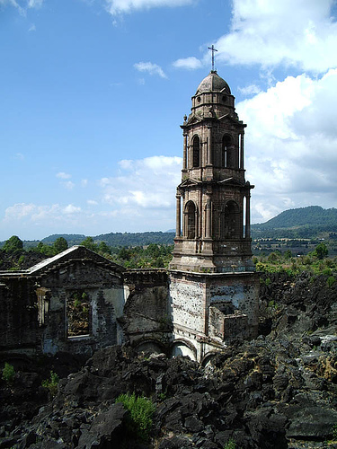
(Caltzontzin and others) were created. San Juan Parangaricutiro’s church
was engulfed; only its towers and ruins protrude from the lava today—a
haunting pilgrimage site.
Scientific Significance
Parícutin
was the first volcano whose complete life cycle (birth to dormancy) was
studied in modern detail. Foshag and González lived nearby for years,
mapping, sampling, photographing, and measuring growth rates, gas
emissions, and lava chemistry (which evolved from basaltic andesite to
andesite). Their USGS bulletins and dozens of papers revolutionized
understanding of monogenetic cinder cones. Later studies examined magma
dynamics, tree recolonization on lava, and ongoing fumaroles (still warm
decades later).
End of Eruption and Current Status
By 1952 the
volcano went quiet. Today the pristine black cinder cone rises
dramatically from the lava field, surrounded by young vegetation (pines
and oaks have recolonized since the 1970s). Minor seismic swarms and
fumarolic steam occur occasionally, but it is considered dormant. The
site is a UNESCO-recognized geoheritage location and part of Pico de
Tancítaro National Park.
Legacy and Tourism
CNN once named
Parícutin one of the Seven Natural Wonders of the World. It features in
books (e.g., Hill of Fire), films, and art. Tourists hike or ride horses
from Angahuan village to the cone (steep final climb) and the buried
church ruins. It remains a powerful symbol of nature’s sudden power and
humanity’s resilience—born in a cornfield, it forever changed the
landscape and lives around it. The volcano stands as a living laboratory
and a reminder that Mexico’s volcanic belt is still very much active.
How to Get There
The volcano lies in a remote, rural part of
Michoacán, roughly in western central Mexico.
From Mexico City —
Take a bus (e.g., from Terminal Observatorio) to Uruapan (about 6–7
hours). From Uruapan, catch a local bus or taxi/combi toward Los Reyes;
ask to be dropped in Angahuan (another ~45–60 minutes). Total public
transport time: 7–9 hours one way.
From Morelia (Michoacán capital, a
beautiful colonial city) — Morelia is closer (~2–3 hours by car/bus to
Angahuan). Organized day tours often depart from here.
From
Guadalajara — About 6 hours by car.
Flying — The nearest airport is
Uruapan (Uruapan International Airport has limited flights, mostly from
Mexico City or Tijuana). From there, taxi or local transport to Angahuan
(~1 hour).
Driving — Renting a car gives flexibility. Roads to
Angahuan are paved but winding; the final stretch can be rough.
High-clearance vehicles are useful if approaching the buried church
directly (though most people go via Angahuan).
Angahuan itself is
a small, traditional Purépecha community with basic
facilities—cabins/guesthouses, simple restaurants serving regional food
(e.g., corundas, uchepos, grilled meats), and a tourist center (Centro
Turístico de Angahuan) where you arrange guides, horses, etc.
Main Ways to Visit and Experience Paricutín
There are two primary
highlights:
The buried church of San Juan Parangaricutiro (La Iglesia
de la Ruina) — The old town was destroyed by lava flows; only the upper
part of the church tower and altar protrude from the black lava sea.
This is much easier to reach than the volcano summit—often a 1–2 hour
walk or short horse ride from Angahuan. It's free to explore the lava
fields around it.
The volcano cone itself — Climbing to the crater
rim is the bucket-list activity.
Options for reaching the
base/summit:
Full hike from Angahuan — ~20–22 km round trip (12–14
miles), 7–9+ hours total, with ~800 m elevation gain. Demanding due to
loose volcanic ash/scree (especially the final steep 40–60 minute
scramble up the cone). Start very early (dawn) to avoid heat and have
time.
Horse + hike combo (most popular) — Horse ride (~2–3 hours each
way) from Angahuan across lava fields to the base of the cone (~10–12 km
one way). Then dismount and hike the final steep ~40–60 minutes up loose
ash to the crater rim. Descent is fast/sliding but dusty—expect shoes
full of black sand. Horse cost: around 600 pesos (~$30 USD) round trip,
often including a guide.
4x4/special tours — Some operators offer 4x4
shortcuts or direct access from other sides (e.g., Nuevo San Juan),
shortening the approach.
Organized tours — Full-day trips from
Morelia or Uruapan (~$200–250 USD) often include transport, guide,
horse, meals, and sometimes stops at nearby attractions like Parque
Nacional Barranca del Cupatitzio in Uruapan.
Practical Tourist
Tips
Best time to visit — Dry season: January–April/May. Rainy season
(June–October) makes lava fields muddy/slippery and trails harder. Early
morning starts beat the heat (high altitude ~2,800–3,380 m /
9,200–11,100 ft) and give better light for photos.
Physical demands —
Moderate to hard. The horse helps a lot, but the final ascent is steep
and exhausting (loose cinders make it feel like climbing sand dunes).
Good fitness required for the full hike. Not recommended for very young
kids, elderly, or those with mobility issues.
What to wear/bring:
Sturdy hiking boots with good ankle support (lava rocks are
sharp/uneven).
Long pants/socks (protection from ash/sun/scratches).
Layers (cool mornings, hot midday sun at altitude).
Hat, strong
sunscreen, sunglasses.
At least 2–3 liters of water per person,
snacks/energy bars.
Camera/phone + power bank (views are
spectacular).
Dust mask or bandana (very dusty on descent and windy
days).
Cash (pesos) — little changes/cards accepted.
Guides
and horses — Strongly recommended. Local Purépecha guides/horse owners
are at the tourist center in Angahuan. Bargain politely but fairly. They
know safe paths and history.
Language — Basic Spanish helps a lot;
English is rare outside organized tours.
Safety — Michoacán has had
security issues in some areas historically, but the Paricutín/Angahuan
zone is generally calm and tourist-friendly (many independent travelers
report no problems). Stick to daylight hours, use reputable
transport/guides, and check current travel advisories.
Stay overnight
— Worth it for an early start. Simple cabins or homestays in Angahuan
(~$20–50 USD/night). Experience Purépecha culture, enjoy campfires, and
stargazing.
Other nearby attractions — Combine with Uruapan's
national park (waterfalls, rivers), the butterfly sanctuaries (if in
season, Jan–March), or Pátzcuaro lake region.
Responsible travel —
Stay on paths (fragile ecosystem), don't take lava rocks as souvenirs,
support local businesses.