
Sian Ka'an Biosphere Reserve (Spanish: Reserva de la Biósfera de
Sian Ka'an) is one of Mexico's largest and most significant
protected areas, located along the eastern coast of the Yucatán
Peninsula in Quintana Roo state, primarily within Tulum
Municipality. Its name, from the Yucatec Maya language, translates
to "Origin of the Sky," "where the sky is born," or "gate of
heaven," reflecting the ancient Maya appreciation for the region's
stunning natural beauty—a vast mosaic of tropical forests,
mangroves, marshes, lagoons, cenotes (sinkholes), petenes (forested
islands), sandy beaches, dunes, and a significant marine section
including part of the Mesoamerican Barrier Reef.
The reserve
spans approximately 528,000–5,281 km² (about 528,148 hectares), with
roughly 408,000 ha terrestrial and 120,000 ha marine, encompassing
over 120 km of coastline. It protects intricately linked ecosystems
that support exceptional biodiversity, including jaguars, pumas,
tapirs, manatees, crocodiles, over 330 bird species, four species of
marine turtles, and rich coral and fish communities.
Pre-Columbian and Ancient Maya History (c. 300 BCE
onward)
Human occupation of the Sian Ka'an region dates back at
least 2,300 years, with evidence of Maya settlement and
sophisticated land use. The Maya developed a sustainable system of
shifting (slash-and-burn) agriculture, complemented by forest and
wetland harvesting. Archaeological discoveries in the 1980s revealed
an extensive 24 km-long irrigation canal system (and others
subsequently uncovered), demonstrating advanced water management in
this low-lying, flood-prone karst landscape. The Maya utilized
approximately 185 plant species from forests and wetlands for over
300 purposes, including food, medicine, dyes, thatch, building
materials, and chewing gum resin (chicle).
The reserve contains
about 23 registered pre-Hispanic archaeological sites, most dating
to the Late Post-Classic period (1200–1500 CE). Notable or
accessible ones include Chunyaxché (also known as Muyil), Vigía del
Lago, and Xamach in the north; these feature temples, shrines, and
structures tied to trade and cosmology. Nearby (just north of the
reserve) lies the prominent coastal Maya site of Tulum, a walled
port city central to sea trade from the 13th to 15th centuries. The
area was part of broader Maya networks, with cenotes and underground
freshwater systems holding cultural and practical significance.
Remnants of later infrastructure, such as the Decauville railway
(Vigía Chico–Santa Cruz, operated 1905–1932), also exist but
post-date the ancient period.
After the decline of major Maya
centers and the Spanish conquest (16th century), the region
experienced significant depopulation and abandonment. Its
inaccessibility, frequent flooding, poor soils, and vulnerability to
storms allowed centuries of natural regeneration, preserving
habitats that would later form the basis for modern conservation.
20th-Century Development, Exploitation, and Early Threats
(1900s–1980s)
In the early 20th century, the area remained
sparsely populated and largely wilderness, with predominantly
Maya-origin communities practicing traditional subsistence. Federal
government policies, bank credits, and concessions encouraged
settlement and economic activity: logging of valuable tropical
hardwoods (mahogany, cedar, lignum vitae), coconut palm plantations
on coastal dunes, and cattle ranching after forest clearing. Three
lighthouses were built, and by the mid-20th century, settlers from
elsewhere arrived. Timber extraction peaked, with companies clearing
forests; fires were routinely used for land clearing.
By the
1970s–early 1980s, rapid regional development—fueled by the rise of
Cancún as a tourist hub—intensified pressures. Quintana Roo's
population grew at 17% annually in some periods; deforestation
reached 6% per year. Over 90% of dune vegetation was converted to
coconuts; overfishing (especially spiny lobster for tourism) surged;
wetlands were drained; sewage and pollution affected groundwater and
reefs; and unregulated hunting, fires, and infrastructure expansion
degraded ecosystems. Valuable timber was nearly exhausted, and
traditional Maya land-use practices began eroding as younger
generations migrated to tourist jobs. An ecological assessment by
the Centro de Investigaciones de Quintana Roo (CIQRO) and forestry
studies (with German cooperation) in 1980 highlighted the
unsustainability, prompting public awareness campaigns.
Establishment as a Protected Area and International Recognition
(1982–1987)
Growing recognition of degradation led to protective
measures. In 1982, the area was initially declared a nature reserve.
On January 20, 1986, Mexican Presidential Decree established it as a
national biosphere reserve—the largest protected area in the Mexican
Caribbean at the time—under the UNESCO Man and the Biosphere (MAB)
Programme. This designation emphasized sustainable human-nature
relationships, aligning with the reserve's sparse population and
traditional uses.
In 1987 (during UNESCO's 11th session), Sian
Ka'an was inscribed as a UNESCO World Heritage Site under natural
criteria (vii) for its aesthetic beauty and rare phenomena (cenotes,
petenes) and (x) for its outstanding biodiversity and ecosystem
diversity. This made it one of Mexico's earliest natural World
Heritage sites. The inscription highlighted its complex hydrological
system, pristine wetlands (among Mesoamerica's best), and role as a
habitat for endangered species.
Post-Establishment
Management, Expansions, and Community Integration (1980s–Present)
Management evolved significantly. Since 2000, the National
Commission of Natural Protected Areas (CONANP, under SEMARNAT) has
overseen it, with 99% federal ownership (1% private on the northern
coast). A comprehensive management plan was developed in the early
1990s (with World Bank/Global Environment Facility support), revised
by 1995, and updated in 2002; it includes zoning, protection,
research, restoration, tourism controls, and cultural safeguards. An
Advisory Council incorporates local communities, government,
academia, and NGOs.
Key expansions and linkages:
1994:
Integration of Uaymil Flora and Fauna Protection Area and Espíritu
Santo Bay Wildlife Refuge.
1998: Separate designation for the
Reefs of Sian Ka'an.
2003 (November 27): Designated a Ramsar
Wetland of International Importance (site no. 1329), recognizing its
vital wetlands.
Non-governmental efforts, notably Amigos de
Sian Ka'an (ASK, founded 1980s), have been pivotal: rural training
programs (from 1989), community ecotourism initiatives,
environmental education, and collaboration on over 200 conservation
projects. Mayan communities in and around the reserve (e.g., Punta
Allen, Punta Herrero, Muyil) participate in sustainable fishing,
lobster management (net fishing reduced dramatically),
catch-and-release sport fishing, guiding, and crafts. Organizations
like Community Tours Sian Ka'an promote low-impact tourism while
preserving traditional knowledge.
Permanent residents remain few
(primarily in coastal fishing villages; estimates historically
~800–1,000, though tourism has increased transient populations).
Traditional activities (subsistence hunting, fishing, plant
collection) continue under regulation, alongside controlled tourism
to fund conservation.
Ongoing Challenges and Conservation
Legacy
Threats persist: proximity to booming tourist centers
(Cancún, Tulum's "Riviera Maya"), overfishing, coastal urbanization,
pollution, invasive species, fires, and cyclones (e.g., Wilma 2005,
Dean 2007). However, protections have halted unchecked ranching and
logging expansion, enabled habitat recovery, and positioned Sian
Ka'an as a model for community-based conservation within the MAB
framework. It buffers against mass tourism while supporting
sustainable livelihoods, research, and education.
Today, Sian
Ka'an exemplifies Mexico's shift from exploitation to integrated
protection of natural and cultural heritage. Its history—from
ancient Maya ingenuity through colonial abandonment and 20th-century
pressures to modern biosphere status—underscores how inaccessibility
once preserved it, and deliberate policy plus community stewardship
now safeguard it for future generations as a "place where the sky is
born."
Sian Ka’an Biosphere Reserve (Spanish: Reserva de la Biósfera de Sian
Ka’an) is one of Mexico’s largest and most ecologically significant
protected areas, located on the eastern (Caribbean) coast of the Yucatán
Peninsula in the state of Quintana Roo. Its Mayan name translates to
“Origin of the Sky” or “Gate of Heaven,” reflecting the stunning visual
contrast of lush green landscapes meeting the turquoise Caribbean Sea.
It was established as a biosphere reserve in 1986 (one of Mexico’s
first) and inscribed as a UNESCO World Heritage Site in 1987 under
natural criteria (vii) and (x) for its outstanding beauty and
biodiversity. It is also a Ramsar Wetland of International Importance.
The reserve protects an intricate mosaic of terrestrial, coastal, and
marine ecosystems along roughly 120 km of pristine coastline.
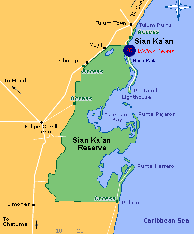
Location and Size
The reserve lies between approximately
19°05′–20°06′ N and 87°30′–87°58′ W, about 130 km south of Cancún and 50
km north of Chetumal. It primarily falls within Tulum Municipality and
the eastern part of Felipe Carrillo Puerto Municipality, extending
across parts of Quintana Roo’s Caribbean coastal zone.
The core area
inscribed as the UNESCO World Heritage Site and commonly referenced for
the biosphere reserve covers 528,148 hectares (5,281 km² or about 1.3
million acres), of which roughly 408,000 ha is terrestrial and 120,000
ha is marine. Some sources note expansions or broader biosphere zoning
bringing the total protected landscape to around 650,000–857,000 ha
(including adjacent areas like Uaymil), but the primary geographical
unit described here is the original ~528,000 ha designation. It
represents about 10% of Quintana Roo and is Mexico’s largest coastal
protected area.
Topography and Geology
Sian Ka’an sits on a
low, flat, partially emerged coastal limestone plain that is part of the
ancient Yucatán Platform and the Mesoamerican Barrier Reef system.
Elevations range from sea level to a maximum of just 10 meters above sea
level (m.a.s.l.), creating an extremely low-relief karst landscape.
The underlying geology consists of Pleistocene-age limestone (relatively
young and porous) with some late Tertiary deposits on slightly higher
ground. Karst processes dominate: rainwater dissolves the limestone,
forming cenotes (deep sinkholes exposing groundwater) and extensive
underground freshwater channels and galleries. Three major geological
faults run southwest–northeast beneath the bays, influencing local
topography and hydrology. Soils are thin and poor—shallow red rendzina
or whitish “sashab” (brittle granular limestone)—with a permanently high
water table never deeper than about 8 m.
Climate
The climate
is tropical with a distinct wet season. Mean annual temperature is
26.5°C (ranging from 22.7°C in January/February to 27.6°C in May/June).
Annual rainfall averages 1,300 mm, with about 75% falling between May
and October (September is wettest; March driest). Relative humidity
hovers around 80%, and the area experiences ~200 cloudy days per year.
Easterly trade winds blow steadily from May to November; northerly winds
(up to 100 km/h) dominate the dry season. The region is vulnerable to
tropical cyclones and hurricanes (June–October, peaking in September),
with an average of one major hurricane every 8 years. Recent storms
(e.g., Dean in 2007, Wilma in 2005) have impacted vegetation and
infrastructure but are part of the natural disturbance regime.
Hydrology
One of the reserve’s most defining geographical features is
its complex, undisturbed hydrological system—a vast network of surface
and subterranean waters fed by the Yucatán’s karst aquifer. There are
almost no surface rivers; rainwater percolates rapidly through the
porous limestone into underground channels.
Seasonal flooding is
dramatic: only ~20% of marshes are inundated in the dry season, rising
to ~70% at the end of the wet season. Key water bodies include:
Two large, shallow bays (Ascensión Bay and Espíritu Santo Bay) covering
>100,000 ha, with variable salinity, mangrove-fringed shores, numerous
islets, and seagrass-covered floors.
105 freshwater and brackish
lagoons.
Hundreds of cenotes and petenes (forested “tree islands” up
to >1 km in diameter emerging from flooded marshes).
These
features are interconnected by underground freshwater flows. The system
acts as a massive natural filter, with mangroves and wetlands trapping
sediments and nutrients. Boundaries often follow natural hydrological
divides (e.g., bay catchments).
Major Ecosystems and Vegetation
The landscape is a dynamic mosaic of 17–23 vegetation types shaped by
subtle elevation changes, flooding, and salinity:
Tropical
forests — Medium semi-evergreen forest on slightly higher,
better-drained ground (~20% of the area); lower semi-deciduous and flood
forests in wetter zones. Dominant trees include sapodilla (Manilkara
zapota), gumbo limbo (Bursera simaruba), and poisonwood (Metopium
brownei).
Wetlands and marshes — Over half the terrestrial area; one
of Mesoamerica’s most pristine wetland complexes, with sawgrass,
spikerush, and palm savannas.
Mangroves — Extensive stands (~90,000
ha or about one-third of the property), including red, black, white, and
button mangroves; fringing the bays and coastline.
Dunes and beaches
— 68 km of white-sand beaches and coastal dunes, partially vegetated
with palms and coastal scrub.
Petenes and cenotes — Unique forested
islands and sinkholes supporting specialized, often endemic flora.
Marine Geography
The marine portion protects ~120,000 ha of the
Mesoamerican Barrier Reef (second-longest in the world), stretching
~110–120 km along the coast. The reef crest lies 1–2 km offshore in
places, creating a natural breakwater. Depths reach ~50 m at the eastern
boundary. Shallow bays and lagoons host dense seagrass beds (primarily
turtle grass Thalassia testudinum). The reef supports ~80 species of
hard corals and over 400 fish species.
Overall Landscape
Character
From the air or sea, Sian Ka’an presents an unforgettable
panorama: emerald-green forests and savannas transition into vast
wetlands and mangrove labyrinths, dotted with sparkling lagoons and
petenes. White-sand beaches fringe the coast, backed by the turquoise
Caribbean and the darker line of the barrier reef. The “many shades of
blue” of the sea and lagoons contrast vividly with the “lush green” of
the vegetation under a vast sky. This low-lying, water-dominated karst
landscape feels both fragile and resilient—protected by the reef from
waves, filtered by mangroves, and sustained by hidden underground
rivers.
Best Time to Visit
The dry season (November–April) is ideal:
calmer seas for boating/snorkeling, lower rainfall, and fewer
mosquitoes. Peak crowds hit December–February (book ahead).
Shoulder
months (May or October–November) offer good deals with milder weather.
Avoid the rainy/hurricane season (June–October, peaking September) for
flooded dirt roads and rough water. Year-round access is possible, but
check sargassum seaweed forecasts for Punta Allen beaches. Wildlife
viewing (especially birds and manatees) can be excellent in the wetter
months.
How to Get There
Sian Ka’an sits right south of Tulum
(5–20 minutes to the entrance). From Cancun it’s ~2–2.5 hours; from
Playa del Carmen ~1 hour.
The reserve has two main visitor zones with
different vibes:
Muyil (inland/lagoon side) — Freshwater lagoons,
Mayan canals, jungle, and ruins. Easiest for day trips.
Punta Allen
(coastal/beach side) — Mangroves, sandbars, reef snorkeling, dolphins,
and a sleepy fishing village.
Entrance points:
Mayan Arch (on
the coastal road from Tulum’s hotel zone) for Punta Allen access.
Muyil turnoff off Highway 307.
The reserve is open daily ~7
a.m.–6 p.m.
Tours vs. DIY: Which Option?
Guided tours (most
recommended) are the easiest, safest, and most responsible way to visit.
Small-group operators pick you up from Tulum (or farther north), handle
transport, fees, boats, guides, and often lunch/snorkel gear. Expect
6–12 people max on quality tours. Prices in 2026: $95–$160+ USD per
adult for a full day (half-day options cheaper). Community-focused
operators like Visit Sian Ka’an emphasize low-impact experiences.
DIY
is possible but more logistical and often more expensive overall
(especially Punta Allen). You’ll need cash, patience, and possibly a
4×4.
Costs (approximate 2026, in MXN; ~20 MXN = 1 USD; confirm
on-site as they can change):
Official CONANP entrance fee: ~225
MXN per person per day (discounts/exemptions for students, seniors,
locals, kids under 12).
Muyil archaeological site extra: ~65–75 MXN.
Boardwalk to dock: ~50 MXN.
Punta Allen road/arch fee: ~105 MXN.
DIY boat (Muyil): fixed ~1,000 MXN per person (max 6 per boat; may
share).
Tours usually bundle everything (transport, guide, boat,
fees, lunch/snacks).
DIY Muyil example: Colectivo/bus from Tulum
ADO station (~75–200 MXN round-trip) + fees + boat = ~$70–100 USD total
per person.
DIY Punta Allen: 4×4 rental + gas + rough 43 km dirt road
(2–3+ hours each way) + overnight recommended. Not ideal for day trips.
Tours win for wildlife knowledge, safety on water/roads, and supporting
conservation.
Top Activities & What to Expect
Boat rides are
the highlight—gliding through emerald mangroves and crystal lagoons
while spotting birds, fish, and possibly manatees or crocodiles.
Floating the ancient Mayan canals (Muyil side) — Lie back in life
jackets and drift through narrow, clear channels dug by the Maya
centuries ago. Surreal and peaceful.
Muyil Ruins — Small but
atmospheric site with a climbable pyramid and observation tower for
panoramic lagoon views. Combine with the boat tour.
Punta Allen side
— Snorkel the reef or sandbars (waist-deep turquoise pools), spot
dolphins/turtles, relax on quiet beaches, or enjoy a seafood lunch in
the village.