Valladolid is a pleasant city with distinct Spanish influence. The central plaza of Valladolid is dominated by a colonial cathedral of San Gervasio on one of its sides. Another notable places of interest include Convent of San Bernadino and Cenote Zaci which is a natural sinkhole with a restaurant by its side. It is quiet common to see citizens of the city to walk around in traditional clothes. Driving narrow streets, especially in the evening is fairly complicated by lack of rules. No one speeds, but drivers often stop to say greet friends. Narrow streets exclude possibility of driving around and you get stuck in a car. It is a fairly safe and friendly town, but just to be on a safe side stay on a busy streets and always be alert. Tourists are usually the easiest target for the criminal syndicate.
Parque Principal Francisco Cantón Rosado (also known as Parque
Principal or the main square): This central plaza serves as the heart of
the city. Surrounded by restaurants, shops, and shaded benches
(including the classic "sillas tú y yo" double chairs), it's a perfect
spot for people-watching, enjoying local snacks like marquesitas, and
soaking in the vibrant atmosphere.
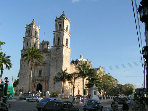
Cathedral of San Servacio (Iglesia
de San Servacio or Templo de San Servacio): Dominating the southern side
of the main square, this impressive colonial church dates back to the
mid-16th century (built around 1545 and later rebuilt). Its tall,
elegant facade with twin towers is one of Valladolid's most recognizable
and iconic landmarks, representing classic Spanish colonial
architecture.
Cenote Zaci: A unique semi-open cenote (natural
sinkhole) located right in the city center, just a short walk from the
main plaza. This large, circular freshwater pool (about 45 meters in
diameter) features clear turquoise waters, hanging stalactites, lush
vegetation, and a cave-like feel. It's a popular spot for swimming and a
true urban natural wonder, tied to the city's Mayan history.
Convent
of San Bernardino de Siena (Ex-Convent and Church): A magnificent
16th-century Franciscan complex (built 1552–1560) at the end of the
picturesque Calzada de los Frailes street. This historic site includes
beautiful architecture, frescoes, and often hosts sound-and-light shows.
It's one of the finest examples of colonial religious buildings in the
region.
Calzada de los Frailes: A charming, tree-lined pedestrian
street leading to the convent, lined with brightly painted colonial
houses in pastel colors, unique doors, and artisanal shops. It's one of
the most photogenic and atmospheric areas for strolling.
Casa de los
Venados: A restored 16th-century private hacienda-turned-museum
showcasing an extensive collection of Mexican folk art. It's a cultural
gem highlighting regional heritage and often praised for its beautiful
courtyard and exhibits.
Pre-Columbian Maya Era (Before 1543)
Long
before Spanish arrival, the area was home to Zací (or Sakiʼ in
Yucatec Maya, meaning “white hawk”). This was the capital of the
Cupules cacicazgo (chiefdom), part of the broader Chikinchel region.
Zací served as an important political, religious, and commercial
crossroads linking major Maya centers such as Chichén Itzá, Ekʼ
Balam, and Cobá.
The city’s central Cenote Zací — a massive open
sinkhole right in the heart of modern Valladolid — provided vital
freshwater and held sacred significance for the Maya. Stones from
ancient Maya structures were later quarried and reused in colonial
buildings, creating a literal physical fusion of cultures still
visible today. By the time the Spanish arrived, the once-thriving
settlement had declined but remained inhabited by Maya communities
under Cupules leadership.
Spanish Conquest and Founding
(1543–1545)
Spanish forces under Francisco de Montejo (the
Adelantado) had struggled for decades to subdue the Yucatán
Peninsula, facing fierce Maya resistance. In 1543, his nephew —
Francisco de Montejo “el Sobrino” (also called “the Nephew,”
distinct from his cousin “el Mozo”) — founded Valladolid on May 28
at Chauac-Há (Chouac-Ha), a lagoon near present-day Tizimín. The
name honored the Spanish city of Valladolid, then the capital of
Spain.
The settlement was established to dominate the resistant
Cupules Maya, with Montejo granting encomiendas (labor and tribute
rights) to 45 conquistadors and placing the town under the patronage
of San Servacio and the Virgin of Remedies. Harsh conditions —
mosquitoes, humidity, and disease — prompted complaints. On March
24, 1545, the town was officially relocated to the higher, healthier
site of the former Maya Zací. The original founder resisted, but the
local council threatened to appeal to the Spanish crown. A Maya
revolt erupted in 1546 but was quickly crushed with reinforcements
from Mérida.
This relocation marked the true beginning of
Valladolid as a colonial outpost.
Colonial Period (16th–18th
Centuries)
Valladolid rapidly grew into the eastern Yucatán’s
most important Spanish center. Franciscan friars arrived early and
constructed the massive Convent of San Bernardino de Siena
(1552–1560) in the Sisal neighborhood — one of the oldest and most
imposing colonial structures in the Americas. Its fortress-like
design (thick walls, battlements) served as a refuge during
conflicts.
The main Iglesia de San Servacio (Cathedral) on the
central plaza was built starting in 1543 but suffered a dramatic
fate in 1705 during a Maya revolt: rebels stormed the church and
killed local Spanish officials who had taken refuge inside,
profaning the building. It was demolished and rebuilt in 1706 with
its facade unusually facing north (most Yucatán colonial churches
face east).
Colonial Valladolid thrived on agriculture, cattle
ranching, and the encomienda system. Its population and economy
expanded, and grand mansions and colorful streets — like the iconic
Calzada de los Frailes (a picturesque avenue lined with restored
colonial homes leading to the convent) — still reflect this golden
era.
19th Century: Independence, Caste War, and Upheaval
After Mexican independence (1821), Valladolid briefly joined the
short-lived Republic of Yucatán (1830s–1840s) and even hosted one of
Mexico’s earliest steam-powered textile factories (“La Aurora”). By
1840, the population reached about 15,000.
The city’s most
traumatic chapter came with the Caste War (Guerra de Castas,
1847–1901) — one of the longest and bloodiest indigenous uprisings
in the Americas. Tensions exploded after Yucatecan authorities
executed Maya leader Manuel Antonio Ay (batab of Chichimilá) in
Valladolid in 1847 on suspicion of conspiracy. Led by Cecilio Chi
and Jacinto Pat, Maya forces rioted in January 1847 and launched a
full siege. On March 14, 1848, they captured the city; half the
fleeing Ladino (non-Maya) population was ambushed and killed en
route to Mérida. Valladolid was sacked and held by Maya rebels for
months before federal troops retook it. The war devastated the
region and only fully ended decades later.
20th Century and
the Mexican Revolution
Valladolid earned the nickname “Sultana
del Oriente” as Yucatán’s second-most important city after Mérida.
Its revolutionary credentials were cemented in 1910. On May 10,
local leaders (including Maximiliano R. Bonilla) signed the Plan de
Valladolid (also called the Plan de Dzelkoop after the nearby
hacienda where it was drafted), denouncing Porfirio Díaz’s
dictatorship and calling for uprising. On June 4, 1910, rebels —
many hacienda workers — seized the city at 3 a.m., cut the railroad
to Mérida, and fought a bloody battle. This is widely regarded as
the “first spark” of the Mexican Revolution in Yucatán, predating
Francisco I. Madero’s national call.
Modern Valladolid
(Post-1920 to Today)
In the 20th century, the city modernized
while preserving its heritage. It retained a strong Criollo
(Spanish-descended) population and colonial mansions. Designated a
Pueblo Mágico on August 30, 2012, Valladolid has experienced a
tourism boom. Its 2020 population was approximately 56,494 in the
city proper.
Today, visitors walk the same streets where Maya
warriors once fought Spanish soldiers and revolutionaries cut rail
lines. A nightly video-mapping light show at the Convent of San
Bernardino dramatically recounts this entire history — from
pre-Hispanic times through conquest and the Caste War.
By car
Valladolid is just off the toll highway
(180D) between Cancún and Merida; the exit is about 5 km (3 miles)
north of the center of town. The old highway (180) runs east-west
through the centre of town, and highway 295 connects south towards
Chetumal, and north to the toll highway and Ek Balam. Both highways
run right through the centre of town on one-way streets, forming the
four sides of the central town square.
By bus
Terminal de
Autobuses (main bus station), Calle 39 No 221, Col Centro (NE corner
of C/ 39 & 46, a couple blocks west of the central plaza (Parque
Francisco Canton) along C/ 39.), ☎ +52 985 856-3448. Frequent first
class services with ADO, ADO GL to Cancun (2hr to east); Merida (2hr
15m west) and Tulum (1hr30m to the southeast). Passengers transfer
in Merida or Cancun to get to additional cities. There are second
class services with Oriente and Mayab to other surrounding towns &
villages nearby such as to Piste, Chichen Itza, Izamal, etc and
further out to Merida, El Progreso and Cancun. The ride will take
longer with the frequent stops to get beyond the immediate area on
second class buses.
Terminal de Autotransportes de Oriente Viejo
(Old bus station), Calle 37 por 54 (Further west along Calle 37.).
The old bus station is now a second class bus station for buses
going to Merida, Cancun, El Progreso, El Piste, Chichen Itza,
Tiziman, Izamal, etc with Autocentro, Mayab and Oriente. The ride
will take longer with the frequent stops to travel longer distances.
The following are taxis and colectivos (shared ride taxis & vans) to
other towns and villages in the surrounding areas. They are
generally quicker in getting there than buses. With the agreements
they have with the local taxi unions they cannot provide local taxi
services. They are:
Sitio de Taxi UnTrac, Calle 37 entre 42 y 44
(Along Call 37 between 42 & 44). Taxis and colectivos going up to Ek
Balam and Hunuku (village).
Colectivos y Taxis a Piste y Chichen
Itza, Calle 39 No 215, entre 44 y 46 (Main entrance east of the main
bus station, past the Restaurante Squimz and Farmacia Similares). To
Piste & Chichen Itza.
Taxis Tizimin y Valladolid (Sitios Taxis
Foraneos), Calle 40, entre 35 y 37 (Inside and in front of the
"Estacionmento Centro" building along Calle 40 between 35 & 37. It's
on the left if going north on Calle 40.).
Collectivos a Ek
Balam, Calle 44 just north of Calle 37. To Ek Balam Ruins.
Valladolid is small enough to make walking a reasonable choice within town. To explore the city you can also rent bicycles at a reasonable rate. Other alternative choices are taxis (Be aware the drivers do not speak English). Locally the streets or Calles are numbered with the odd numbered streets going east and west and even numbered streets going north and south. The street numbers get higher as you go from east to west and from north to south. Directions and addresses can be given with the locations such as Calle 41 No 201, entre 42 y 44 meaning Building #201 along Calle 41 (going east & west) between 42 & 44 (going north & south).
Valladolid (Spanish: Valladolid; Maya: Sakiʼ) is a city and the seat
of Valladolid Municipality in the eastern Yucatán state, Mexico, on the
Yucatán Peninsula. It sits inland at approximately 20°41′22″N
88°12′06″W, about 170 km (105 mi) east of the state capital Mérida, 40
km (25 mi) east of the famous Maya site Chichén Itzá, and 150 km (93 mi)
west of Cancún. The municipality spans 1,117 km² (431.4 sq mi).
Regional Context on the Yucatán Peninsula
The Yucatán Peninsula is a
vast, low-relief limestone platform (part of the larger Yucatán Platform
on the North American plate) covering roughly 181,000 km² across
southeastern Mexico, northern Belize, and Guatemala. Valladolid lies in
the northern lowlands of Yucatán state, in a characteristically flat
landscape shaped by ancient marine deposition and the massive Chicxulub
asteroid impact (66 million years ago), whose buried crater rim
influences regional karst features.
Topography and Elevation
The terrain around Valladolid is exceptionally flat and low-lying, with
minimal relief typical of the northern Yucatán Peninsula. Elevations
range narrowly from about 17 m to 32 m above sea level in the immediate
vicinity, with an average of ~23 m (roughly 75 ft). City-center
measurements sometimes cite lower figures around 9–24 m depending on the
exact point. There are no hills, valleys, or significant slopes—contour
lines on topographic maps are widely spaced or absent over large areas.
This flatness results from the dissolution of porous limestone bedrock
over millennia, creating a classic karst landscape. The city and
surrounding countryside sit on a nearly featureless plain, making the
horizon appear endless when viewed from elevated points like church
towers.
Geology and Hydrology
Valladolid rests on thick layers
of soluble limestone (with some dolomite and evaporites) that once
formed the floor of an ancient sea. Rainwater, slightly acidic from
dissolved CO₂, percolates rapidly through fractures, dissolving the rock
and forming an extensive network of underground caves, rivers, and
aquifers—the largest such system in the world. Surface water is
virtually nonexistent: there are no permanent rivers or streams in the
northern Yucatán; any lakes or swamps are marshy and often brackish.
Instead, the region’s hydrology revolves around cenotes (from Maya
d’zonot, meaning “sinkhole” or “well”). These are natural openings where
the limestone ceiling of underground caverns has collapsed, exposing the
freshwater aquifer. The peninsula hosts an estimated 10,000 cenotes;
Valladolid itself is famous for Cenote Zací (also spelled Zaci), a large
semi-open sinkhole located directly in the city center. It served as the
original water source for the ancient Maya settlement of Zací and
remains a popular swimming and tourist site today, with clear turquoise
freshwater, overhanging rock walls, stalactites, and lush surrounding
vegetation. Many other cenotes cluster nearby, forming part of the
broader “Ring of Cenotes” influenced by the Chicxulub impact structure.
Climate
Valladolid has a tropical savanna climate (Köppen Aw)—hot
year-round with a pronounced wet season and moderate to high humidity
(annual average ~74%). It lies in the trade-wind belt near the Tropic of
Cancer, so easterly winds predominate, and the city is typically a few
degrees hotter than coastal areas due to its inland, low-elevation
position.
Temperatures: Annual mean ~26.6°C (79.9°F). Daily highs
average 33°C (91°F), peaking at 36°C (97°F) in May (afternoons often
exceed 38°C/100°F). Lows range from 18°C (64°F) in January to 23°C
(73°F) in summer. Record high: 42.8°C; record low: 7.6°C.
Precipitation: ~1,141 mm (44.9 in) annually. Dry season (November–May)
sees minimal rain (e.g., January ~39 mm); wet season (June–October,
driven by the Mexican monsoon and tropical waves) brings heavy
downpours, with October the wettest (~177 mm) and up to 18 rainy days in
September. Hurricanes and “nortes” (short, intense storms) can occur.
Other: Sunshine averages ~2,778 hours/year; humidity peaks in the wet
season (~79% in October). Mosquitoes thrive in humid conditions.
Detailed monthly data (1981–2000 averages) confirms the hot, seasonally
wet pattern typical of inland northern Yucatán.
Vegetation and
Environment
Valladolid lies within the Yucatán moist forests
ecoregion. This semi-deciduous tropical forest sees 25–50% of trees lose
leaves during the drier months. The landscape mixes taller forest
patches with scrublands, supporting biodiversity including birds,
reptiles, and mammals typical of the peninsula (though deforestation has
reduced original cover). Farther north the vegetation grades into drier
Yucatán dry forests with more scrub and cacti, while coasts feature
mangroves. The flat limestone soil (locally called saskab or “white
soil”) is thin and drains quickly, limiting surface agriculture but
supporting resilient tropical species.
The surrounding countryside
appears as a patchwork of green forest, cleared fields, and scattered
cenotes, visible in aerial views as a uniform, low-canopy expanse.