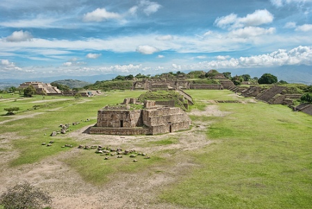
Location: 8 km (5 mi) West of Oaxaca, Oaxaca
Map
Tel. (951) 516 1215
Open: 8am- 6pm daily
Entrance Fee: 30 pesos, Free on Sundays and holidays
www.inah.gob.mx
Monte Albán is one of the most important pre-Columbian
archaeological sites in Mesoamerica, located in the Valley of
Oaxaca, Mexico, about 9 km (6 miles) east of the modern city of
Oaxaca de Juárez. Perched atop a artificially leveled mountain ridge
at around 1,940 m (6,400 ft) elevation, it offers commanding views
of the surrounding valleys and was chosen partly for its
defensibility.
It served as the pre-eminent Zapotec capital and
urban center for nearly a millennium, from roughly 500 BCE until its
major abandonment around 700–900 CE. The site is renowned for its
monumental architecture, early writing, sophisticated urban
planning, and role in regional power dynamics. Together with
Oaxaca’s historic center, it was designated a UNESCO World Heritage
Site in 1987.
Best Time to Visit
Opening hours: Daily 8:00 AM to 4:30/5:00 PM (last
entry around 4:00 PM). The site and museum are included in the ticket.
Ideal timing: Go early in the morning (arrive when it opens) for cooler
temperatures, better light for photos, fewer crowds, and a more magical
atmosphere. Afternoons can get very hot with little shade.
Season: Dry
season (November–April, especially Nov–Feb) is best for clear skies and
comfortable weather. Rainy season (May–Oct) brings afternoon showers; visit
early to avoid them. Weekdays are less crowded than weekends or holidays
(Sundays offer free entry for Mexican citizens/residents).
Time needed:
Plan 2–3 hours on-site (more if exploring deeply or with a guide), plus
travel time. Allow a half-day total.
Note on weather/heat: The site
is exposed with almost no shade. Temperatures rise quickly; it can feel
intense even in “milder” months.
Getting There from Oaxaca City
Shuttle bus (Autobuses Turísticos, recommended for most visitors):
Affordable and convenient round-trip option (~M$90–140). Operators like
Lescas Co (from near Zócalo or Hotel Rivera del Ángel) and Viajes Turísticos
Mitla run hourly departures starting ~8:30 AM. Returns every hour. Flexible
stay time.
Taxi: ~M$200–250 one way (bargain; agree on price upfront).
Good for groups or direct travel. Arrange via hotel or Zócalo ranks. Harder
to find return taxis late in the day.
Guided tour: Hassle-free with hotel
pickup, transport, and expert commentary. Popular options combine Monte
Albán with other sites (e.g., artisans’ towns). Good for deeper history.
Other: Rental car (easy parking on-site) or public bus (cheap but involves
extra walking and less practical). Hiking is possible but not recommended
alone due to safety and heat.
On-site: Two parking areas; shuttles/taxis
drop at the lower one. Walk up or use any transport provided.
Tickets
and Practical Info
Entry fee: Around M$210 per adult (increased in 2026;
confirm on-site). Children under 13 free. Cash/cards accepted; museum
included.
Facilities: Small museum (Spanish-focused, some English), café
with views, restrooms (bring your own paper/tissues), and vendors for
maps/snacks. Limited accessibility (some ramps/elevator to viewpoints, but
most involves stairs/uneven terrain; not stroller-friendly).
Guides:
Available on-site (~M$800–1,000 per group; English/Spanish). Or use audio
tours/apps/maps for self-guided. Signs in English/Spanish help.
What
to See: Highlights and Suggested Route
The site centers on a large Main
Plaza with platforms, pyramids, and structures you can climb for views. Key
spots (roughly clockwise or as you explore):
Main Plaza & Platforms: Vast
ceremonial space. Climb the South Platform for the best panoramic views of
the plaza, valley, and site scale. North Platform has sunken patios,
temples, and elite residences.
Building J (Observatory): Unique
arrow-shaped structure aligned with astronomy; features “conquest slabs”
with hieroglyphs.
Ball Court (Juego de Pelota): Early Mesoamerican
example for the ritual ball game.
Danzantes (Temple of the Danzantes):
Famous carved stone figures (likely depicting captives or sacrificial
victims, not dancers).
Tombs: Over 170, including notable ones like Tomb
7 (famous for Mixtec treasures, now mostly in Oaxaca’s museum) and Tomb 5.
Some have intricate carvings.
Other: Stelae with glyphs, System IV,
pyramids, terraces, and residential areas. The layout reflects cosmic and
social order.
Start at the museum for context, then explore the
plaza. Take your time climbing structures (where allowed) and soaking in the
views. The site feels less commercial than places like Chichen Itza.
Visiting Tips
Essentials to bring: High-SPF sunscreen, hat, sunglasses,
comfortable walking shoes (for stairs/uneven paths), reusable water bottle
(refill if possible; stay hydrated), light snacks, camera/binoculars. Light,
breathable clothing. Insect repellent optional.
Health/Safety: Watch
steps on ruins (climbing allowed but respect rules). Site is generally safe;
standard precautions apply. Altitude and sun can fatigue you—pace yourself.
Limited shade; avoid midday peak heat.
Photography: Great light in
morning; tripods may need permits. Respect no-touch rules on carvings.
Respect: Don’t climb restricted areas or remove anything. This is a sacred
cultural site.
With kids/families: Fun for climbing/views; free for young
children. Not ideal for very young due to terrain.
Accessibility:
Partial; some viewpoints accessible, but core site challenging.
Combine
with: Oaxaca City sights, Mitla ruins, Hierve el Agua, or artisan villages
for a full day.
Food: Café on-site or eat before/after in Oaxaca (famous
for cuisine).
Founding and Early Development (Middle to Late Preclassic / Monte
Albán I Phases, ~500 BCE–100 BCE)
The hilltop was largely unoccupied
before ~500 BCE (end of the Rosario phase). At that time, the Valley of
Oaxaca had competing chiefdoms centered on places like San José Mogote
in the Etla branch. Monte Albán’s founding appears tied to a major
socio-political shift often called the “Monte Albán Synoikism”—a rapid
centralization where populations from dispersed settlements converged on
this neutral, previously empty ridge in a buffer zone between rival
polities.
This move was dramatic: by the end of Monte Albán Ia (~300
BCE), the population reached an estimated 5,200, while San José Mogote
declined sharply. By Monte Albán II (~100 BCE–200 CE), it grew to around
17,000, becoming one of Mesoamerica’s largest cities.
Key
achievements in this era:
Massive engineering: Leveling the ridge
and constructing extensive terraces, dams, canals, and platforms carved
directly from the mountain.
Early monumental architecture: Temples,
plazas, and structures using dressed stone.
Evidence of militarism
and expansion: “Danzante” sculptures (likely depicting captives or
sacrificed enemies with hieroglyphic elements) and early Zapotec
writing, among the earliest in Mesoamerica.
Urban planning:
Orientation of buildings (often north-south), ball courts, and defensive
features.
The site emerged as the capital of an expansionist
Zapotec polity that dominated the Oaxacan highlands through military
conquest, alliances, and colonization (e.g., into Cuicatlán, Ejutla, and
Sola de Vega).
Classic Period Flourishing (Monte Albán IIIA and
IIIB, ~200–700/750 CE)
This was Monte Albán’s zenith, with a peak
population possibly reaching 15,000–35,000+ (estimates vary; the broader
site and terraces supported a large urban area). It exerted strong
influence across the Valley of Oaxaca and beyond.
Highlights:
Main Plaza: A grand 300-meter north-south esplanade with platforms,
pyramids, temples, and the iconic ball court (tlachtli). Flanked by the
North and South Platforms.
Architectural influences: Strong ties to
Teotihuacan (central Mexico), visible in styles and evidence of a
Zapotec neighborhood there. Elite exchanges, trade, and possible
diplomatic relations.
Cultural and scientific advancements: Refined
writing system (glyphs on monuments and tombs), calendar, astronomy
(alignments possibly tied to solar events), and complex religious
practices. Elaborate tombs (over 170 found, some with rich offerings and
murals).
Economy and society: Intensive agriculture via terraces and
irrigation; craft production; long-distance trade. It was a political,
religious, economic, and ceremonial hub.
The city symbolized
sacred topography, with its layout harmonizing built structures and
natural landscape.
Decline and Transformation (Monte Albán IV–V,
~700/750–1521 CE)
By the Late Classic (Monte Albán IIIB/IV, ~500–1000
CE), centralized power waned. Regional elites at secondary centers
(e.g., Lambityeco, Mitla, Cuilapan, Zaachila) asserted autonomy.
Population at the capital dropped sharply (e.g., from ~16,500 to
~4,000), and the site was largely abandoned as a major urban center by
~900–1000 CE, though small-scale reoccupation and ritual use continued.
Reasons for decline are not fully settled but likely included a
combination of factors common in Mesoamerica around this time:
environmental stress (possible drought or overexploitation), internal
social tensions, shifting trade routes, and the rise of competing
polities. It coincided roughly with broader Classic period collapses
(e.g., Maya centers).
In the Postclassic (Monte Albán V), Mixtecs
occupied and reused parts of the site, particularly as a sacred burial
ground. They repurposed Zapotec tombs (famously Tomb 7, excavated by
Alfonso Caso in 1932, yielding extraordinary gold and turquoise
artifacts blending styles). Zapotec and Mixtec cultures fused to some
extent. The area saw influence from later powers like the Aztecs but
remained fragmented into smaller polities until the Spanish arrival.
Spanish Colonial Period and Rediscovery
Monte Albán was in ruins
by the time of the Spanish conquest (early 16th century). The nearby
Valley saw the founding of Antequera (now Oaxaca de Juárez) in 1529 on a
grid plan, exemplifying colonial urbanism adapted to seismic conditions.
The site attracted explorers from the colonial era onward (e.g.,
Guillermo Dupaix, A.F. Bandelier). Systematic excavations began in the
early 20th century: Leopoldo Batres in 1902, followed by major work
under Alfonso Caso (1931 onward), who excavated much of the visible
core, established the ceramic chronology (Phases I–V), and uncovered key
tombs. Later projects by Kent Flannery, Richard Blanton, Gary Feinman,
and others mapped the broader settlement and earlier valley
developments.
Overall Layout and Urban Planning
The monumental core centers on
the Main Plaza (Gran Plaza or Esplanade), an artificially leveled
rectangular open space measuring approximately 300 meters (980 feet)
north-south by 150–200 meters (490–660 feet) east-west. It was paved
with white stucco plaster for a dramatic visual effect.
The plaza is
oriented roughly north-south, harmonizing built volumes with open spaces
and the surrounding topography. Structures are mostly aligned to
cardinal directions (especially east-west for solar observations),
reflecting advanced planning. The site includes terraces, dams, canals,
and reservoirs for water management, plus residential areas on slopes
below the core.
Key construction features:
Platforms built with
talud-tablero (sloping talud walls and vertical panels), wide stairways
flanked by alfardas (balustrades), and double "scapulary" panels for
solidity.
Rubble-fill cores faced with cut stone slabs (often
orthostats in alternating vertical/horizontal courses).
Thick stucco
finishes (sometimes painted); walls up to 3 feet (nearly 1 meter) thick
in elite structures.
Adaptation to seismic activity through massive,
low, voluminous forms with solid foundations.
The site evolved
through phases (Monte Albán I–V), with major urbanization and plaza
development in Phases II and III.
Major Structures and
Architectural Highlights
1. North and South Platforms
These
massive platform mounds anchor the ends of the Main Plaza. Grand
staircases (some impressively wide and steep) lead to elevated areas
with additional temples and elite buildings. The South Platform measures
about 120m x 112m and stands around 11m high. These served ceremonial,
political, and elite residential functions, offering commanding views.
2. Building J (The Observatory)
One of the most distinctive
structures in Mesoamerica. Unlike the rectangular, cardinally aligned
buildings, it has an unusual arrowhead or pentagonal shape and is
rotated at an angle (pointing roughly southwest). Its orientation likely
served astronomical purposes, such as tracking celestial events,
solstices, or stars. The facade features carved stone slabs (conquest
monuments recording victories). It exemplifies Zapotec innovation in
sacred architecture and astronomy.
3. Ballcourt(s)
Monte Albán has
one of the earliest known ballcourts in Mesoamerica (I-shaped, with
sloping stucco playing surfaces). Located on the east or west side of
the plaza, it was used for the ritual ball game (ulama), symbolizing
cosmic battles, fertility, or political contests. The architecture
includes parallel structures with inclined walls.
4. Temples and
Platforms (e.g., Systems, Montículos)
Temples typically feature a
two-room plan: a front porch or antechamber for communal access and a
rear sanctuary for restricted rituals. Many are built atop stepped
pyramidal platforms with broad stairways. Examples include structures on
the east and west sides of the plaza, plus the North Platform's Sunken
Patio (a large ritual compound ~50m per side).
5. Building L and the
Danzantes
On the western side, Building L includes the famous "Wall
of the Danzantes" — carved stone slabs depicting naked, dynamic (often
contorted or mutilated) human figures, possibly representing captives,
dancers, or sacrificial victims. These early carvings (Monte Albán I)
are among the site's most iconic artistic-architectural elements,
integrated into platform walls.
6. Elite Residences and Tombs
Elite palaces were square-based with central courtyards surrounded by
rooms in hierarchical order. They often included sub-patio tombs
(stone-walled, sometimes with murals). Commoners lived on terraced
slopes in simpler wattle-and-daub or adobe-on-stone homes.
7. Other
Features
Building P and various montículos (mounds) for
temples/residences.
Carved stelae and monuments throughout the plaza.
Extensive terracing and hydraulic systems (drains, cisterns,
reservoirs).
Materials and Techniques
Local sandstone was
quarried, cut into slabs, and hauled uphill. Construction used rubble
fill, lime plaster/stucco, and precise stone masonry without mortar in
many cases. Later phases show refinements, with some structures built
over or incorporating earlier ones (e.g., buried early temples). The
site spans several square kilometers, including clusters of mounded
architecture.
Context and Significance
Monte Albán's
architecture reflects Zapotec cosmology, political power, and
engineering prowess. It was a sacred landscape "carved out of the
mountain," symbolizing control over nature and society. The site's
planning influenced Mesoamerican urbanism, and its mix of ceremonial,
residential, and defensive elements (later phases) highlights its role
as a capital. It is a UNESCO World Heritage Site (with Oaxaca's historic
center).