Location: Sauk County Map
Devil’s Lake (Tee Wakącąk or Te Wakącąk / Sacred Lake or Spirit
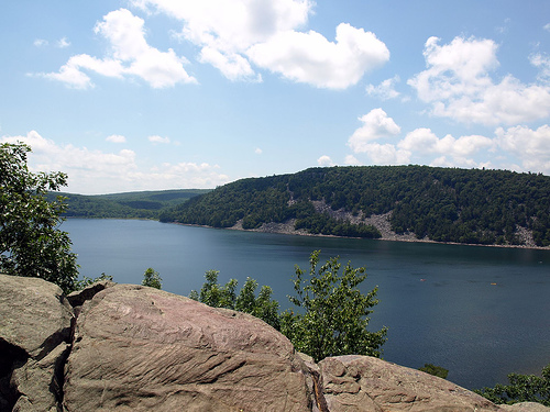
Lake) in Sauk County, Wisconsin, is a dramatic endorheic (or
cryptorheic) lake nestled in a gorge within the Baraboo Range, now
the centerpiece of Devil’s Lake State Park.
It attracts over a
million visitors annually for its quartzite bluffs, hiking,
climbing, swimming, boating, and scenic beauty. Its history spans
billions of years geologically and thousands of years of human
presence, marked by Indigenous reverence, 19th-century tourism and
resource extraction, and 20th-century conservation.
The Baraboo Range’s quartzite bluffs are among North America’s oldest
exposed rocks, dating back ~1.6–1.7 billion years. Ancient river sands
deposited in shallow seas compacted into sandstone, then metamorphosed
under heat and pressure into hard quartzite. Tectonic forces uplifted
the ranges, erosion carved valleys and gorges, and later seas deposited
more sediments before rivers re-exposed the bluffs.
During the last
Ice Age (~12,000–15,000 years ago), the Wisconsin Glacier stopped short
of fully covering the area, depositing terminal moraines that dammed an
ancient river valley at both ends, creating Devil’s Lake. The lake is
roughly rectangular (about 1 mile north-south, 0.5 mile east-west),
40–50 feet deep on average, with sandy glacial bottoms and large talus
(scree) slopes at the base of the cliffs. Features like ripple marks,
potholes, and unconformities (gaps in rock layers) are visible along
trails.
Major Landmarks and Rock Formations
Balanced Rock: One
of the park’s most iconic sights, this large quartzite boulder appears
precariously perched on a ledge high on the East Bluff, overlooking the
lake. It’s reachable via a short but rewarding trail (part of longer
loops) and offers stunning panoramic views. Glacial and erosional forces
shaped it.
Devil’s Doorway: A dramatic natural rock arch or
window formation on the East Bluff, formed by erosion and frost wedging.
It provides breathtaking views of the lake and surrounding hills,
especially striking in fall foliage or misty conditions. It’s a popular
short hike destination.
Talus Slopes and Cliffs: Massive piles of
broken quartzite boulders at the base of the bluffs on three sides of
the lake, created by freeze-thaw cycles. These are prominent features
for hikers and climbers.
Parfrey’s Glen State Natural Area
(adjacent but managed with the park): A deep, scenic gorge with steep
cliffs, a mountain-like stream, waterfall elements, and unique Cambrian
sandstone formations (different from the main quartzite). It’s
Wisconsin’s first State Natural Area, offering a lush, shaded hike
contrasting the open bluffs.
Other notable features include
Elephant Cave, potholes, ripple marks in the rock, and various overlooks
like Prospect Point on the West Bluff (highest point, ~500 ft above the
lake).
Cultural and Historical Sites
Effigy Mounds: Ancient
Native American burial and ceremonial mounds in animal shapes (e.g.,
lynx, sparrow) and linear forms, located near the Nature Center and
elsewhere. These are culturally significant; respect them and learn more
at park programs.
Civilian Conservation Corps (CCC) Structures:
Trails, buildings, benches, and other infrastructure built in the 1930s
by CCC workers. The Nature Center and many trails reflect this legacy.
Historic Resorts and Development: In the late 19th/early 20th century,
the area had hotels, summer homes (including Ringling Brothers
connections), and recreation facilities. Most were removed as the park
was established in 1911, restoring its natural character.
Recreational Highlights Tied to Landmarks
The park offers ~29 miles
of hiking trails (easy lakeside paths like Tumbled Rocks Trail to
strenuous bluff climbs), rock climbing on quartzite cliffs (a Midwest
premier spot), swimming at two sandy beaches, boating/kayaking, fishing,
birdwatching (over 200 species), and winter activities.
Popular hikes
combine landmarks: East Bluff Trail (to Devil’s Doorway and Balanced
Rock), West Bluff Trail (cliff-edge views), and loops around the lake.
The Nature Center provides exhibits on geology, history, and wildlife,
plus programs.
Tips: The park gets very crowded on weekends/holidays
(May–October); arrive early. Vehicle admission sticker required. Stay on
trails for safety and to protect fragile features.
The park is part of the Ice Age National Scenic Trail, which passes
through for about 13.7 miles, highlighting glacial geology like
moraines, kettles, talus slopes, and potholes. Trails are well-marked
but can be busy in summer; many involve stone steps, uneven rocky
terrain, and potential drop-offs—proper footwear is essential. About 1.5
miles are accessible (e.g., parts of Tumbled Rocks and Grottoes).
Popular Loops and Iconic Hikes
Many visitors do a full Devil’s
Lake Loop (around 5–6+ miles, moderate to strenuous), combining East
Bluff or West Bluff trails with lakeshore paths like Tumbled Rocks. This
offers bluff-top views, rock formations, beaches, and varied terrain.
Devil’s Lake via West Bluff Trail (popular ~4.8–7.7 km / 3–4.8 mi
loop, moderate, 2.5–3+ hours): Starts at the North Shore, climbs the
West Bluff (quartzite cliffs, ups/downs, stone steps), passes Prospect
Point and Cleopatra’s Needle, with panoramic lake views. Descends to the
south shore, then returns via Tumbled Rocks or East side. Rewards
include beach access and Balanced Rock option. Highly rated for scenery.
East Bluff and East Bluff Woods Trail Loop (~3 mi / 4.8 km, moderate,
1.5–2 hours): Asphalt with stone steps along the bluff edge and woods.
Features Elephant Rock, Elephant Cave, Devil’s Doorway, and lake
overlooks with drop-offs.
Devil’s Doorway Loop (~2.1 mi / 3.4 km,
hard): Leads to the iconic Devil’s Doorway rock formation with great
views. Involves woods, overlooks, steep stairs, and oak forests.
Key Trails by Difficulty (with distances and highlights)
Trails are
often color-coded (red = difficult, yellow = moderate, green =
easy/moderate). Here are major ones:
Difficult/Strenuous (steep
climbs, rocky, stone steps):
Balanced Rock Trail (0.4 mi one way, ~1
hr): Steep climb on the south face of East Bluff via uneven rocky
staircase/stone steps. Famous Balanced Rock formation ~2/3 up (short
side path). Spectacular lake views; can be crowded. Connects to East
Bluff Trail.
Potholes Trail (0.3 mi, very difficult): One of the
steepest/shortest. Passes through a narrow rock split; ends at ancient
glacial potholes. Challenging elevation; dramatic.
C.C.C. Trail (0.3
mi): Steep stone steps from Group Camp to bluff top; scenic views.
East Bluff Trail (1.7 mi one way, most difficult): Follows the bluff top
with ups/downs, stone steps (esp. north end), lake vistas, Elephant
Rock/Cave. Connects many features.
West Bluff Trail (1.4 mi one way):
Similar to East Bluff but sometimes considered slightly harder—rim of
cliffs, panoramic views, steep south ascent, stone steps north. Includes
Prospect Point.
Moderate:
East Bluff Woods Trail (1.3 mi):
Wooded parallel to East Bluff (no direct lake views), moderate
ascents/descents, good for quieter hike.
Uplands Trail / Loop (3.8
mi): Rises ~325 ft, partly grassy/meadow, shared with bikes in places,
views of Wisconsin River possible. Wet in low areas.
Roznos Meadow
Trail (1.8 mi): Meadow/prairie then woods climb to Uplands; glacial
moraine views.
Easy to Moderate/Easiest (lakeshore, flatter):
Tumbled Rocks Trail (1–1.3 mi): Popular paved/uneven path along
lakeshore through talus boulders at West Bluff base. Scenic lake views,
pine forests; great for families/strollers (northern half rougher). Can
loop with West Bluff.
Grottoes Trail (0.7 mi): Level gravel at East
Bluff base; cool natural grottos, connects bluff climbs. Accessible.
Steinke Basin Loop (2.4–2.8 mi): Level grassy/wooded through former
glacial lake bed; streams, beaver evidence, bridges. Muddy after rain.
Johnson Moraine Loop (2.8 mi): Flat-ish atop terminal moraine; kettles,
marshes, crosses highway.
Parfrey’s Glen (0.7 mi): Moderate into a
narrow, mossy gorge (State Natural Area—stay on trail). Spectacular,
unique ecology.
Longer/Backcountry: Sauk Point Trail (4.5 mi)
reaches high points in Baraboo Hills with varied terrain.
Practical Tips
Best Time: Spring/fall for fewer crowds and fall
colors; summer for swimming/beaches but busier. Trails not maintained in
winter (snowshoeing possible).
Access: North and South Shore areas
with parking, beaches, picnic spots, concessions, boat rentals.
Visitor/Nature Center for maps/info.
Gear/Safety: Sturdy shoes
(rocky/slippery when wet), water, bug spray, sun protection. Watch for
drop-offs, poison ivy, wildlife. Dogs allowed on leash.
Fees:
Wisconsin State Park vehicle admission sticker required (day passes
available).
Other Activities: Rock climbing (famous quartzite),
swimming, paddling, biking (limited trails like Uplands), birding,
camping.
Location and Overview
The lake lies in a narrow gorge within the
Baraboo Hills (part of the Baraboo Range), a canoe-shaped geological
structure. The park itself spans 9,217 acres (the largest in Wisconsin),
with the lake covering about 360–374 acres. It is roughly rectangular: a
little over a mile long (north-south) and about half a mile wide
(east-west). Maximum depth is around 40–50 feet (some sources note up to
~47 feet), with the water surface at an elevation of roughly 961 feet
(lake level varies). The bluffs rise dramatically 500 feet above the
lake in places.
Geological History (Over 1.7 Billion Years)
The geography results from a multi-stage process involving ancient seas,
mountain-building, erosion, and glaciation:
Precambrian Origins
(~1.6–1.7 billion years ago): The core of the Baraboo Range consists of
highly resistant Baraboo quartzite, formed from sand deposited in
shallow seas, later metamorphosed under heat and pressure into a hard,
non-porous rock. This makes the bluffs among the oldest exposed rock
outcrops in North America.
Folding and Erosion: Tectonic forces
buckled the quartzite into the North and South Ranges, creating a
depression (Baraboo Valley). Softer rocks eroded away, forming gorges.
Ancient rivers carved gaps, including the one now occupied by the lake.
Seas and Sedimentation: Later seas deposited sands and limey materials,
burying parts of the hills. Subsequent river erosion re-exposed the
quartzite bluffs and reopened gaps.
Ice Age and Lake Formation
(~12,000–15,000 years ago): During the Wisconsin Glaciation, the glacier
advanced but did not fully override the western Baraboo Hills. It
deposited terminal moraines (ridges of rock, gravel, and debris) that
plugged both the north and south ends of the pre-existing gorge in an
abandoned river valley. This created a natural dam, trapping water and
forming the lake. Without the glacier, the gorge might still be a river
channel.
The lake is endorheic (closed basin) with no natural
surface outlet — water enters via springs, rainfall, snowmelt, and small
tributaries, and leaves primarily through evaporation. This makes levels
highly sensitive to climate. The bottom sand is largely glacial in
origin.
Talus slopes (piles of broken rock at the base of bluffs)
formed from freeze-thaw cycles. Iconic formations include Balanced Rock,
Devil’s Doorway, and various cliffs popular for rock climbing due to the
durable quartzite.
Topography and Surrounding Features
Bluffs:
Steep quartzite cliffs line the east and west sides, rising up to 500
feet. The East Bluff and West Bluff offer panoramic views. The North and
South Bluffs complete the enclosure.
Moraines: The North Glacial
Moraine ( ~80 feet thick) forms the northern shore; the Southeast
Moraine (~130 feet thick) lies between bluffs.
Uplands and Valleys:
Surrounding hills feature mixed conifer-deciduous forests, loess-covered
soils, talus fields, and gorges like Parfrey’s Glen (a state natural
area nearby with Cambrian sandstone). The broader Baraboo Range includes
hardwood forests.
Trails and Access: Over 29 miles of hiking trails
range from lakeshore paths to steep bluff climbs. Popular ones include
the West Bluff Trail, East Bluff Trail, and Ice Age Trail segments.
The terrain supports diverse microhabitats, from rocky cliffs to
forested slopes and wetlands.
Hydrology and Climate
As a
closed basin, Devil’s Lake has no outflow, so levels fluctuate with
precipitation and evaporation. It is spring-fed and generally clear to
moderately clear. Water levels are monitored by USGS; they can rise
significantly in wet periods, occasionally affecting shores and
low-lying areas.
The region has a humid continental climate with cold
winters, warm summers, and moderate precipitation. The lake moderates
local temperatures somewhat, and the bluffs create microclimates
influencing vegetation and wildlife.
Notable Geographical
Elements
Rock Formations: Balanced Rock, Devil’s Doorway, and
extensive talus slopes.
Biodiversity Context: The setting supports
rich flora/fauna, including rare species, due to varied topography and
geology.
Human Context: Effigy mounds and long Native American
history (e.g., names meaning “spirit lake”). The park is heavily visited
for its scenery, climbing, and trails.
Deep Geological History (Prehistoric Foundations)
The Baraboo
Range’s quartzite bluffs, which frame the lake, are among the oldest
exposed rock formations in North America, dating back about 1.6–1.7
billion years. Ancient rivers deposited sand into shallow seas; over
time, this became sandstone and then metamorphic quartzite under heat
and pressure. Tectonic forces buckled the rock into the North and South
Ranges, creating a depression (the Baraboo Valley). Subsequent seas
deposited more sediments, which were later eroded, exposing the
resistant quartzite again.
Before the last Ice Age, the area featured
a gorge carved by an ancestral river (possibly the Wisconsin or Baraboo
River) flowing through a gap in the South Range. Around 15,000–20,000
years ago, during the Wisconsin Glaciation, a glacial lobe advanced,
depositing terminal moraines that dammed both ends of the gorge. As the
glacier retreated, meltwater and later springs/rain filled the enclosed
valley, forming the lake (no surface inlet/outlet, though underground
drainage may connect to the Baraboo River). The lake is about 374 acres,
with depths up to 47 feet (average ~30 feet). Talus slopes, boulders,
and dramatic cliffs result from freeze-thaw cycles and glacial activity.
This geology makes the site scientifically significant and a popular
destination for rock climbing on the hard quartzite.
Indigenous
History and Cultural Significance
Humans have used the area for at
least 12,000–16,000 years (post-glacial), with Ho-Chunk (Ho-Chunk
Nation, also historically Winnebago) oral traditions suggesting much
deeper connections—potentially spanning multiple ice ages. The lake and
surrounding lands were (and remain) sacred to the Ho-Chunk and other
tribes, including Sauk, Fox (Meskwaki), and Kickapoo peoples who passed
through.
Ho-Chunk name: Tee Wakącąk (or variations like Te
Wakącągara, Ta-wah-cun-cunk-dah, Tewakakak), translating to “Sacred
Lake,” “Holy Lake,” or “Spirit Lake”—a place where spirits live, worthy
of reverence (not “devilish”). The adjacent southern land is Maa Wákąčąk
(“Sacred Earth”). It features in oral histories, ceremonies, and stories
(e.g., involving spiritual beings or fasting visions).
Evidence
includes effigy, linear, and conical mounds built ~1,000+ years ago by
mound-builder cultures (ancestors or related to Ho-Chunk), some on north
and south shores. These are culturally significant burial or ceremonial
sites. Historic-era Native peoples visited but did not maintain
long-term settlements in the immediate valley.
European settlers
often misinterpreted or reframed Indigenous spiritual sites as “Devil’s”
places due to Christian cultural lenses associating non-church spirits
with the demonic—a pattern seen at other U.S. sites (e.g., Devils
Tower). Alternative early English names included “Lake of the Hills,”
“Wild Beauty Lake,” or “Spirit Lake,” but “Devil’s Lake” prevailed by
the mid-19th century.
There have been modern discussions about
renaming it back to Spirit/Sacred Lake to honor the original
significance.
19th-Century Exploration, Settlement, and Tourism
Boom
Early European contact: John De La Ronde (1832) is the first
known non-Native visitor. Naturalist Increase Lapham visited in 1849,
describing challenging boulder-strewn shores.
Settlement and early
development followed in the 1850s–1860s, with a bathhouse and properties
like Kirkland (Noble C. Kirk, 1854) on the south shore, featuring
cottages, orchards, and picnic areas.
Railroad era (1873 onward): The
Chicago & North Western Railroad line along the east shore made the lake
accessible from Chicago, Milwaukee, and beyond. Hotels proliferated
(e.g., Minniwauken House/Cliff House and Annex on north shore, Lake
View, Messenger on south). Visitors arrived by steam train for day trips
or extended stays, enjoying steamers like the Capitola and Minniwauken,
dances, band picnics, croquet, hayrides, regattas, and even a zoo.
Ulysses S. Grant visited; elephants from circuses (linked to the
Ringling Brothers, who had local ties) reportedly bathed there.
Resource extraction: Logging cleared forests (altering composition from
tall oaks to smaller maples); quartzite quarries operated near the lake
(blasting echoed in the valley), shipping stone by rail. A
vineyard/winery also existed on the south shore.
Tourism brought
economic growth but also environmental strain and overcrowding concerns.
Establishment of the State Park (Early 20th Century)
By the early
1900s, conservation sentiment grew nationally and locally. In 1906,
Baraboo residents formed a committee and published “An Appeal for the
Preservation of the Devil’s Lake Region,” advocating protection of
scenery, geology, archaeology, and ecology while removing hotels, timber
operations, and quarries. Landscape architect John Nolen highlighted the
area’s potential.
1911: Devil’s Lake became Wisconsin’s third
state park (after Interstate and Peninsula). The state acquired ~1,100
acres, including former hotel properties; many cottage owners sold or
leased back. Early efforts focused on halting quarrying and building
infrastructure.
CCC era (1930s–1940s): The Civilian Conservation
Corps camp (200 young men, 1934–1941) built iconic stone structures
(e.g., park headquarters, shelters, Chateau pavilion), trails with
quartzite steps, roads, and more. They also fought fires, removed
invasives, and improved access. Many features remain in use today.
20th Century to Present: Recreation, Stewardship, and Challenges
Camping evolved from informal setups in the 1920s–30s to developed sites
like Northern Lights and Ice Age campgrounds. Golf was available for
decades before conversion to camping. Attendance grew from ~100,000
(1919) to over a million annually.
The Devil’s Lake Concession
Company (founded 1949, nonprofit) supports operations, food, rentals,
and park funding.
Naturalists like Ken Lange (first full-time in the
Wisconsin system) advanced interpretation, research, and education.
Ongoing management by the Wisconsin DNR addresses water quality
(swimmer’s itch, occasional algae blooms), invasive species, rock
climbing ethics, rattlesnakes, and visitor impacts. Recent expansions
(e.g., land acquisitions) continue conservation. Proposals for nearby
development have sparked opposition to protect the area.
The park spans over 9,000 acres and supports exceptional diversity
due to varied habitats: upland deciduous and mixed conifer-hardwood
forests (one of the largest contiguous hardwood forests in the Midwest),
dry prairies, bedrock glades, oak woodlands/savannas, talus slopes,
wetlands, and the lake itself. It lies mostly in the Western Coulee and
Ridges ecological landscape, with a bit in the Central Sandhills.
Flora (Plants)
The park hosts around 880 plant species,
reflecting its diverse microhabitats.
Forests and Woodlands: Dominant
overstory includes red oak, with understory of red maple. Mixed
deciduous forests feature oak, maple, basswood, and some conifers.
Southern dry-mesic forests and oak woodlands are prominent, with efforts
to restore them by removing invasives like buckthorn, garlic mustard,
and oriental bittersweet.
Prairies, Glades, and Open Areas: Dry
prairies and bedrock glades support species like prairie coreopsis,
prairie alumroot, field pussy-toes, large-flowered yellow false
foxglove, shooting star, columbine, wild bergamot, New England aster,
Jacob's ladder, and others. Eastern prickly-pear cactus occurs in some
nearby reclaimed prairie areas.
Wetlands and Aquatic Plants: The lake
and associated wetlands feature native aquatics such as common waterweed
(Elodea canadensis), large-leaf pondweed (Potamogeton amplifolius), fern
pondweed (Potamogeton robbinsii), reeds, cattails, and water lilies.
These provide fish and waterfowl habitat.
Special Areas: Parfrey's
Glen State Natural Area (Wisconsin's oldest) and other SNAs (South
Bluff/Devil's Nose, East Bluff, Devil's Lake Oak Forest) harbor unique
and rare plants, ferns (over 20 species noted in nearby areas), and
spring ephemerals like hepatica, trillium, and orchids in shaded spots.
Notable/Problematic Plants: Wild parsnip, poison ivy, nettles, poison
oak, and sumac are common along trails—hikers should stay on paths.
Invasives are actively managed to protect native communities.
The
park's flora supports rich pollinator habitats, including for the
federally endangered rusty-patched bumble bee.
Fauna (Animals)
Mammals
Up to 38–40 species reported. Common or notable ones include:
White-tailed deer (frequently seen).
Smaller mammals: raccoon,
skunk, opossum, rabbit, squirrels, voles, mice, shrews, moles,
woodchuck, muskrat, beaver, porcupine.
Predators and others: coyote
(listen for howls), gray and red foxes, weasels, mink, otter, badger,
bobcat.
Larger/rarer: black bear (occasional), mountain lion (very
rare), gray wolf (rare).
Four species of bats are present. Quiet
trails like Uplands, Sauk Point, or Roznos Meadow offer better mammal
viewing opportunities, especially at dawn/dusk in spring or fall.
Birds
Exceptional birding: 228 species recorded, with ~105–115
nesting (nearly half of Wisconsin's total) and many migrants. Highlights
include:
Waterbirds and raptors: Great Blue Heron (notable rookery on
south shore), bald eagles, osprey, turkey vultures (common, especially
soaring or roosting), peregrine falcons, various ducks, and warblers
(multiple species).
Forest birds: Scarlet tanager, pileated
woodpecker, wood duck, hooded warbler, Acadian flycatcher, owls
(screech, great horned, barred, saw-whet).
Others: Flycatchers and
many songbirds/migrants. Hotspots include the lake, Messenger Creek
willows, Steinke Basin wetlands, and quieter wooded areas.
Spring and
fall migrations are prime times.
Reptiles and Amphibians
Diverse herpetofauna:
Snakes: 10 species, including the timber
rattlesnake (venomous but reclusive; slim chance of encounter—stay on
trails). Also northern watersnake.
Turtles: 4 species (e.g., painted,
snapping; some nesting activity).
Frogs/Toads/Salamanders: 10 frog
species (spring choruses notable), 1 toad, 5 salamanders.
Fish
29 species in the lake, mostly native. Includes largemouth and
smallmouth bass, walleye, northern pike, panfish (bluegill, perch
common), and stocked trout (brown). Carp and white bass are non-native.
Fishing is popular (license required).
Insects and Others
58
species of butterflies, including the rare white admiral.
Other
invertebrates support the food web, including pollinators like bumble
bees.
Native American Origins and the Name
The lake formed at the end of
the last Ice Age (around 10,000–12,000 years ago) as a terminal moraine
filled with meltwater, now fed by springs and rainwater. It has no
natural inlet or outlet, which adds to its mysterious aura.
Indigenous peoples, particularly the Ho-Chunk (Winnebago) Nation, have
long regarded it as sacred. They called it variations of
Ta-wa-cun-chuk-dah ("Sacred Lake," "Spirit Lake," or "Holy Lake"). Some
Sioux-related names translate closer to "Mystery Lake" or "Bad Spirit
Lake." European settlers translated or misinterpreted these as Devil’s
Lake, likely due to associations with evil spirits, water monsters, or
the dramatic, "cursed" landscape.
The area shows evidence of ancient
human occupation, with stories of spirits and monsters dating back
millennia.
Thunderbird vs. Water Spirits Legend (Core Creation
Myth)
One of the most prominent legends explains the lake’s formation
and "Devilish" nature through an epic battle between Thunderbirds
(powerful, benevolent giant birds associated with thunder, lightning,
and the upper world) and malevolent water spirits or monsters
(underworld creatures like horned serpents/Unktehila).
According to
Ho-Chunk and related traditions passed to early settlers: Water spirits
inhabited a body of water here. Thunderbirds launched a massive assault,
hurling thunderbolts and stones from the skies. The water spirits
retaliated with boulders, waterspouts, and tempests that ensnared birds
and dragged them underwater. The battle raged for days, shattering
cliffs, uprooting trees, and scarring the land—creating the
boulder-strewn shores and bluffs seen today.
The Thunderbirds
ultimately prevailed, driving the evil spirits away (or trapping some in
the depths). This victory is why the lake is sometimes called "protected
by Thunderbirds." Thunderbirds were said to migrate seasonally to battle
these dangers, aligning with bird migration patterns.
This myth ties
into broader Native American lore of Thunderbirds battling water
monsters, with Devil’s Lake as a specific "power zone" or site of
ongoing spiritual conflict.
Lake Monster / Serpent Legends
Tales of a creature in the lake persist, often linked to the water
spirits. Descriptions include a serpentine, fish-like, or amphibious
beast resembling the Loch Ness Monster—large humps breaking the surface,
massive unidentified forms, or an octopus/kraken-like entity.
During droughts (e.g., one recounted by a local chief to an early
missionary), the lake allegedly split or shallowed, revealing a
thrashing creature that terrified onlookers before returning to deeper
water.
Sightings from bluffs or kayaks continue; some photos
(including one from a 2010 kayaker that went viral as "proof") show
ambiguous shapes, often debated as logs or wakes.
Ties to Unktehila
(horned serpent) pushed into the lake by Thunderbirds.
Skeptics
note the lake’s biology makes a breeding population unlikely, but the
legends endure.
Ghostly and Apparitional Legends
Ghost stories
at the lake itself are sparser than cryptid tales, but they exist:
Native American Canoe Ghost: Apparitions of a Native American
paddling a ghostly canoe on the lake at night.
Chief’s Daughter /
Princess Ke-she-ah-ben-o-qua Legend: A romantic tragedy where a chief’s
beautiful daughter falls in love with a French trader or another figure.
Variations involve her drowning (or sacrificing herself) in the lake
after tragedy, with her body never recovered. Shadows of lovers or her
spirit are said to appear on moonlit waters. Some accounts link it to a
specific deep spot ("Devils Hole" or similar), renaming the lake "Lake
of the (Evil) Spirit." A memorial plaque reportedly exists near the
north end.
EVPs (electronic voice phenomena) captured by paranormal
investigators at certain spots.
Related Baraboo-area hauntings
(near the park) amplify the spooky vibe:
Phantom hitchhiker on
Highway 12 (old army jacket or camo, vanishes if picked up).
"Ghost
elephants" from Ringling Bros. Circus history—rumors of spectral
pachyderms stomping, rattling houses, and even knocking down a barn in
the 1930s (reported in Fate magazine and Chicago Tribune).
Haunted
sites like the Old Baraboo Inn (former saloon/brothel), Al Ringling
Theater, Circus World Museum, etc.
Other Cryptids and Spooky
Elements
Bigfoot/Sasquatch: Occasional sightings and rumors in the
park and surrounding woods, with reports of large bipedal figures.
Giant birds/Thunderbirds: Modern sightings of oversized birds overhead.
Alligator: A 1901 report of someone swearing they saw one (likely
misidentification).
Real hazards like rattlesnakes on trails and
seasonal midge fly swarms add to the "cursed" feel.