Location: Hocking County Map
Area: 2,356 acres
Hocking Hills State Park in southern Ohio (near Logan) is a stunning natural area famous for its dramatic sandstone cliffs, recess caves, waterfalls, hemlock-shaded gorges, and lush forests. It offers excellent hiking with relatively short but rewarding trails, making it ideal for day trips or multi-day visits. The park is free to enter (no admission fee), open year-round from dawn to dusk, and features several distinct hiking areas connected by trails like the Grandma Gatewood Trail.
Best Time to Visit
Spring (March–May): Best for roaring waterfalls
after rain. Wildflowers bloom, but trails can be muddy. Fewer crowds
early in the season.
Summer (June–August): Lush greenery, longer
days, but peak crowds and bugs. Waterfalls may have lower flow in dry
periods. Go early or on weekdays.
Fall (September–November): Peak
foliage makes it magical, but very busy on weekends. Cooler temps are
great for hiking.
Winter: Quietest time with ice formations and
frozen waterfalls creating a wonderland. Trails can be icy—use caution
or crampons/microspikes. Some facilities limited.
Tip: Weekdays
and early mornings (before 9–10 AM) are best to avoid crowds and secure
parking. Peak seasons (fall weekends, summer) see lots fill up fast.
Getting There & Navigation
About 1 hour southeast of Columbus via
US-33. Drive times: ~3 hours from Cleveland, ~2.5 from Cincinnati.
Cell service is spotty in gorges—download offline maps (AllTrails, park
app, or official PDFs) and the Hocking Hills app for trails, local info,
and coupons.
Areas are spread out; you'll drive between trailheads
(e.g., Old Man's Cave to Ash Cave ~10–15 minutes).
Parking is free
but limited at popular spots. Arrive early.
Key Trails &
Highlights
Most trails are moderate with stairs, bridges, and rocky
sections. Stay on marked trails for safety (steep drop-offs, cliffs).
Old Man's Cave (most popular, ~1-mile loop, 45–90 min): Upper/Lower
Falls, Devil's Bathtub (swirling pool), bridges, Sphinx Head rock
formation, and the recess cave (actually a rock shelter). Connect via
Grandma Gatewood Trail to other areas.
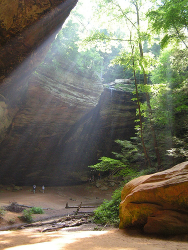
Ash Cave (0.25–0.5 miles
round-trip, easy): Massive recess cave with a seasonal waterfall. Gorge
trail is wheelchair-accessible; rim trail adds views. One of the largest
in the state.
Cedar Falls (~0.5–1 mile one-way, moderate): Beautiful
waterfall in a deep gorge with hemlocks. Steep stairs; connects to
longer hikes.
Other highlights:
Cantwell Cliffs (~1–2 miles,
difficult): Narrow passages, steep steps, cliffs—less crowded.
Rock
House (~0.8 miles, moderate): Tunnel-like cave with windows.
Conkles
Hollow (Nature Preserve, no pets): Gorge or rim trail with views.
Longer option: Grandma Gatewood Trail (~6 miles one-way) linking Old
Man's Cave–Cedar Falls–Ash Cave.
Pro tip: Combine trails for
longer hikes (e.g., Old Man's Cave to Ash Cave). Check conditions, as
some are one-way.
Practical Visiting Tips
What to Bring:
Sturdy hiking shoes/boots (trails rocky/muddy/slippery), water, snacks,
rain jacket, trekking poles (for stairs/ice), headlamp if needed, bug
spray (summer), layers (temps vary), and a head net for bugs. No
swimming in falls/creeks.
Safety: Steep cliffs/drop-offs—supervise
kids closely. Watch for slippery rocks/stairs. Flash flooding possible
in gorges after heavy rain. Trails close at dusk (no night hiking).
Leave no trace.
Pets: Leashed dogs allowed on most trails but not in
nature preserves like Conkles Hollow/Rockbridge.
Accessibility: Ash
Cave gorge and parts of others are wheelchair-friendly. Check specifics.
Facilities: Visitor center at Old Man's Cave (maps, info, restrooms).
Picnic areas, but limited food—bring your own or eat nearby in Logan.
Fees/Camping: No day-use fee. Campground has electric/full hookups,
cabins (reserve 6 months ahead via ODNR). Hike-in primitive sites
available.
Crowds & Etiquette: Busy areas get congested—yield to
others, stay on trails, pack out trash. Consider less-visited spots like
Cantwell Cliffs for solitude.
Beyond Hiking
Ziplining/canopy
tours (Midwest capital for this).
Wineries, breweries, distilleries,
and local dining (Appalachian/Amish fare).
Canoeing/kayaking,
horseback riding, or visiting nearby Lake Logan.
Winter ice
formations or fall foliage photography.
Lodging: Cabins, lodges,
Airbnbs, campgrounds—book early for peak times. The state park lodge is
convenient.
Geological History
Over 330 million years ago (during the
Mississippian or Pennsylvanian periods), the region was covered by the
ancient Atlantic Ocean. Currents deposited vast layers of sand and
gravel, which compacted and cemented into Blackhand sandstone (named for
a soot-drawn Native American hand petroglyph on a similar formation near
Newark, Ohio).
This sandstone has three distinct layers: resistant
upper and lower zones sandwiching a softer, more easily eroded middle
layer. Erosion by streams, groundwater, freezing/thawing, and wind over
millions of years carved the park’s signature features—recess caves
(shelters), cliffs, gorges, and waterfalls—primarily in the middle
layer.
Around 10,000 years ago, the retreating Wisconsin Glacier
dramatically reshaped the landscape. It buried the ancient Teays River
under glacial silt and reversed the flow of the Hocking River,
contributing to the “bottle-shaped” gorge that inspired the river’s
name.
The cool, moist microclimate in the gorges supports northern
species like hemlocks, Canadian yews, birches, and rare plants (e.g.,
roundleaf catchfly, lady’s slipper orchids), alongside diverse wildlife.
Native American and Prehistoric Use
Evidence shows human presence
dating back at least 7,000 years, possibly to Paleo-Indian nomadic
hunters at the end of the Ice Age (fluted projectile points found nearby
in Ross County).
The Adena culture (mound-builders, ~1000 BCE to 800
CE) and later Fort Ancient people (~1000–1700 CE) used rock overhangs
and recesses for shelter.
In the mid-1700s, the Wyandot (with a
village called Oldtown near present-day Logan), Delaware, and Shawnee
hunted, traveled, and lived in the area. They called the river
Hockhocking (“bottle river” in Delaware, or Wea-tha-Kagh-Qua-sepe in
Shawnee), referring to its narrow, bottle-neck gorge with a waterfall
north of Lancaster.
Specific sites show long use:
Ash Cave —
Named for large ash piles from centuries of campfires; used as shelter.
Rock House — A tunnel-like cave (only true cave in the park, not a
recess shelter) with evidence of Native American ovens, water collection
systems, and possibly turpentine production.
Trails like the
Shawnee Trail and Great Trail crossed the region. A historical marker at
Ash Cave now honors Native American inhabitants and researchers.
European Settlement and 19th Century
The Northwest Ordinance (1787)
and Treaty of Greenville (1795) opened the area to Euro-American
settlement in the late 1790s. Early pioneers found abundant game (deer,
elk, turkey, bear; the last local bison killed ~1799 along Queer Creek).
Small farms developed, aided by grist mills.
Hocking County was
organized in 1818; by 1820 it had over 2,000 residents. The Hocking
Canal (completed 1840) boosted settlement and trade.
Industrial
activity included:
A powder mill near Rock House and grist mill at
Cedar Falls (1835).
Charcoal iron furnaces in the Hanging Rock region
(early 1850s), using local timber for charcoal and sandstone-derived
iron for tools, ammunition, and Union cannons during the Civil War.
Coal mining later supplemented the economy.
Old Man’s Cave is
named for Richard Rowe, a late 18th/early 19th-century hermit/trader
from Tennessee who reportedly lived there with his dogs until his death
(supposedly buried in the cave).
By the late 1860s, the caves and
gorges became popular local picnicking and hiking spots, though poor
roads limited access.
Establishment as a State Park (20th Century
Onward)
Concerns over logging and degradation led to conservation. In
1915–1916, Ohio passed laws enabling state forest acquisitions for
reforestation and recreation. In 1924, the state bought its first 146
acres (including Old Man’s Cave), initially under the Department of
Forestry as state forest park land. More land followed in the 1920s.
The Civilian Conservation Corps (CCC) in the 1930s (e.g., Camps Hocking
and Logan, including Company 505 and 526) built trails, stone steps,
bridges, roads, and performed erosion control and tree planting
(hundreds of thousands of trees). WPA projects added further
improvements.
In 1949, with the creation of the Ohio Department of
Natural Resources (ODNR) and Division of Parks, Hocking Hills officially
became a state park.
Development continued:
1950s–1960s:
Prisoner labor from Hocking Honor Camp aided reforestation.
1970s:
Dining lodge (opened ~1970/1972; original destroyed by fire in 2016, new
one in 2022) and log cabins boosted visitation.
Grandma Gatewood
(first solo female Appalachian Trail thru-hiker at age 67) trained here
and led annual January hikes; a trail section is named for her.
The park expanded with areas like Ash Cave, Cantwell Cliffs, Cedar
Falls, Rock House, Whispering Cave (added publicly in 2017), and others.
It now offers extensive hiking (25+ miles of trails), camping, cabins,
and programs.
Modern Era and Significance
Hocking Hills draws
millions of visitors annually for ecotourism, hiking, rock climbing,
swimming (Lake Logan), birding, and more. It balances preservation with
recreation while surrounded by Hocking State Forest.
The park
preserves not just natural beauty but layers of human history—from
ancient shelters and Native trails to pioneer industry and New Deal
conservation. Features like CCC-built structures and interpretive sites
highlight this heritage.
Geological History and Formation
The park’s striking topography
originated over 330–350 million years ago during the Mississippian
Period (Lower Carboniferous). At that time, the region lay under a
shallow inland sea or near a delta where rivers from ancient eastern
highlands deposited thick layers of sand, silt, and gravel. These
sediments compacted and cemented into the Blackhand Sandstone (named
after a Native American petroglyph resembling a black hand on a cliff
near Newark, Ohio).
This formation is 100–200 feet thick in places
and features varying cementation: harder upper and lower layers sandwich
a softer middle zone. Over millions of years, uplift exposed the rock,
and erosion—primarily by streams, groundwater, and weathering—sculpted
the landscape. Key processes include:
Stream incision along
joints (fractures) in the rock.
Sapping (undercutting by groundwater
seepage), which enlarges recesses and contributes to cliff retreat and
gorge formation.
Differential erosion of softer layers, creating
overhangs, recess caves, and dramatic cliffs.
Later glacial
influences (e.g., the Wisconsin Glacier ~10,000 years ago) altered
regional drainage, reversing some river flows and contributing to the
current Hocking River system.
The result is a rugged, “extreme”
topography unusual for much of Ohio’s flatter glacial plains—think high
cliffs, deep gorges, and isolated rock shelters amid a plateau
landscape.
Topography and Key Landforms
The park is
characterized by steep-sided gorges carved into the sandstone, with
elevations varying significantly over short distances. Ridgetops are
drier and more exposed, while gorges trap moisture and cooler air,
creating microclimates.
Major features and areas include:
Old
Man’s Cave: A popular recess cave along Old Man’s Creek gorge. The trail
passes Upper Falls, Middle Falls, Lower Falls, Devil’s Bathtub (a
pothole-like feature), and other formations. The gorge showcases layered
sandstone with overhangs.
Ash Cave: Ohio’s largest recess cave (~700
feet long, up to 90–100 feet high). A waterfall often cascades over the
rim into an amphitheater-like space. It features honeycomb weathering
(tafoni) from mineral dissolution and erosion.
Cedar Falls: Features
one of the highest-volume waterfalls in the area (named for mistaken
“cedar” hemlocks). Water plunges ~50 feet into a deep gorge.
Rock
House: The only true tunnel-like cave in the park (not a recess cave),
~200 feet long, 20–30 feet wide, with natural “windows” (openings)
letting in light. Formed by erosion through jointed sandstone.
Cantwell Cliffs and Conkle’s Hollow: Rugged cliffs and one of Ohio’s
deepest gorges, with steep trails, overhangs, and seasonal waterfalls.
Conkle’s Hollow has notable case-hardened rock faces and active erosion.
Whispering Cave: A recess cave known for acoustics, accessible via
Hemlock Bridge Trail.
Other elements include rock shelters, slump
blocks (fallen rock masses from joints), arched bridges, and narrow
passages. Over 25 miles of trails (gorge/rim loops of varying
difficulty) connect these, with some wheelchair-accessible sections.
Hydrology and Climate
Streams like Old Man’s Creek and Queer
Creek drain the area, feeding the Hocking River. Waterfalls are most
impressive in spring or after rain; they can slow or freeze in winter,
creating ice formations.
The climate is temperate with ~40 inches of
annual rainfall, mild summers (July highs ~85°F), and cold winters
(January lows ~19°F). Gorges maintain cooler, moister conditions
year-round, supporting northern flora.
Flora and Fauna
The
dissected terrain creates diverse habitats. Dry ridgetops host oaks,
pines, and hickories. Moist gorges support hemlock, yellow/black birch,
Canada yew, beech, maples, and ferns—reminiscent of more northern
climates. Rare plants include roundleaf catchfly, filmy fern, and
orchids.
Wildlife includes white-tailed deer, barred owls, ruffed
grouse, wild turkeys, bobcats, and various birds. The area supports rich
biodiversity due to its varied microclimates and forest cover.
Overall Character
Hocking Hills stands out as a pocket of
Appalachian-style ruggedness in Ohio, shaped by ancient marine
deposition, differential erosion, and joint-controlled weathering of
resistant Blackhand Sandstone. Its mix of cliffs, caves, waterfalls, and
shaded gorges makes it a premier destination for hiking, nature study,
and seasonal beauty (vibrant fall colors, winter ice, spring
wildflowers).
Flora (Plants, Trees, Wildflowers, and More)
The park’s vegetation
reflects its geology (primarily Blackhand sandstone) and varied
topography. Deep gorges host cool, shaded hemlock forests, while
ridgetops feature drier oak communities. Over 2,000–2,200+ species of
plants and animals are noted in the broader Hocking Hills area.
Trees and Canopy Species:
Eastern Hemlock (Tsuga canadensis):
Towering, shade-tolerant conifers dominate cool gorges, creating a
primeval, cathedral-like atmosphere. These are glacial relicts.
Yellow Birch (Betula alleghaniensis) and Black Birch (Betula lenta):
Common in moist, northern-like habitats.
Canada Yew (Taxus
canadensis): A low-growing evergreen shrub, another northern relict.
Deciduous hardwoods: Tulip Poplar (large yellow/orange blooms), American
Beech, Oaks (including chestnut oak on drier ridges), Maples, and
Pawpaw.
Other notables: Sourwood, Virginia Pine, and Pitch Pine on
ridges; Rhododendron species (great rhododendron and flame azalea in
nearby preserves).
Shrubs, Ferns, Mosses, and Lichens:
Lush
undergrowth with ferns, shrubs, and mosses/lichens on rock faces.
Rare or notable: Roundleaf Catchfly, Lady’s Slipper Orchids, Devil’s
Walking Stick, Sullivantia (one of Ohio’s rarest plants), mountain
laurel, blueberry, and deerberry.
Wildflowers:
Spring (late
March–early June) brings spectacular displays, with over 300 species of
flowers, shrubs, and trees blooming. Peak viewing often occurs in
April–May along trails like Ash Cave, Old Man’s Cave, Cedar Falls, and
Conkle’s Hollow.
Key examples by trail/season:
Ash Cave & Old
Man’s Cave: Virginia bluebells, columbines, wild geraniums, trillium
(white and others), trout lilies, spring beauties, foam flower, purple
dead nettle.
Cedar Falls & Conkle’s Hollow: Purple coneflowers,
black-eyed Susans, blazing stars, Dutchman’s breeches,
jack-in-the-pulpit, mayapples.
Others: Bloodroot, blue-eyed Mary,
dwarf larkspur, fire pink, golden ragwort, phlox, violets, rue anemone,
bluets, dwarf crested iris, showy orchid, Virginia waterleaf, and more
(including yellow lady slipper, star of Bethlehem, and various
buttercups).
Summer and fall bring additional blooms, berries,
and fall foliage (vibrant from hemlocks contrasting with hardwoods). The
area also supports diverse fungi/mushrooms.
Fauna (Wildlife)
The park’s forests, gorges, streams, and cliffs support a wide variety
of mammals, birds, reptiles, amphibians, fish, and invertebrates. Many
species are more active at dawn/dusk or in less-trafficked areas.
Mammals:
White-tailed Deer: Very common; frequently seen foraging
in woodlands, especially at dawn/dusk.
Bobcats: Rare and elusive,
active at night; prey on small mammals.
Black Bears: Occasional
visitors (more common in the broader region); generally avoid humans but
can be protective of cubs.
Foxes (red and gray): Red foxes more
commonly observed; active at dawn/dusk/night.
Wild Turkeys: Heard
gobbling in spring; common in wooded areas.
Ruffed Grouse, squirrels,
rabbits, and others.
Bats: Multiple species (e.g., little brown bat,
big brown bat, Indiana bat) roost in caves; essential for insect
control.
Birds:
Hocking Hills is excellent for birding,
especially in gorges and cliffs. Species include:
Raptors: Hawks,
turkey vultures, barred owls.
Songbirds: Warblers (e.g., magnolia,
pine, black-throated green, Canada, cerulean), vireos, thrushes, tufted
titmouse, chickadees, goldfinches, swallows, dark-eyed juncos, sparrows,
siskins.
Others: Whip-poor-wills (haunting calls at dusk), bluebirds,
red-breasted nuthatches, brown creepers.
Reptiles and Amphibians:
Snakes: Copperhead (camouflaged, common in rocky/wooded areas), black
rat snake, ring-necked snake, timber rattlesnake (endangered, rare),
five-lined skink.
Turtles: Eastern box turtle (woodland species,
common on forest floor).
Salamanders: Dusky and red-backed
salamanders thrive in cool, moist recesses.
Frogs/Toads: Wood frog,
green frog, gray tree frog, northern leopard frog, American toad,
Fowler’s toad.
Fish and Aquatic Life:
Streams and waterways
support sunfish, colorful darters, black-nosed dace, least brook
lamprey, mottled sculpin, smallmouth/largemouth bass, channel catfish,
white crappie, bluegills, rainbow trout, saugeye, and quillback.