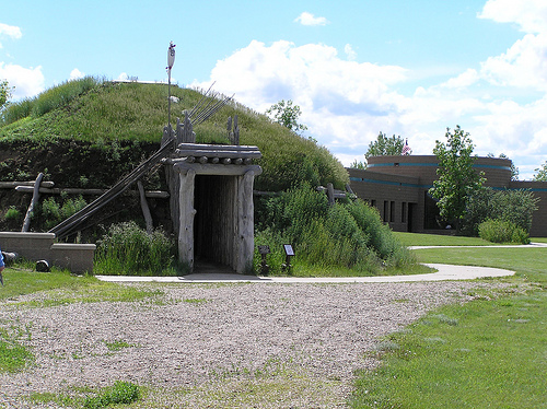
Location: Stanton, ND Map
Area: 1,758 acres (7.11 km²)
Open: 8am- 6pm Memorial Day- Labor
Day
8am- 4:30pm Winter time
Closed: Thanksgiving, Christmas, 1 Jan
Entrance Fee: Free
Knife River Indian Villages National Historic Site (NHS), located just north of Stanton in central North Dakota's Mercer County, preserves the archaeological remnants and cultural legacy of Northern Plains Indian villages that thrived along the Knife River for centuries. Spanning 1,758 acres (711 hectares) of floodplain, terraces, and upland prairies at the confluence of the Knife and Missouri Rivers, the site was established by Congress on October 26, 1974, to protect the last major intact village sites of the Hidatsa and Mandan tribes, as well as evidence of earlier Arikara occupation. This area served as a vibrant trade and agricultural hub from the 15th to the mid-19th century, where earthlodge-dwelling farmers, hunters, and traders interacted with each other and, later, European explorers. The site is particularly significant for its connection to Sacagawea (also spelled Sakakawea), the Shoshone woman who guided the Lewis and Clark Expedition and grew up among the Hidatsa at the Awatixa Village (now called Sakakawea Village). With no entrance fees and year-round access, it attracts around 50,000 visitors annually, offering a window into pre-colonial Indigenous life through reconstructed structures, interpretive trails, and exhibits. Managed by the National Park Service (NPS), the site emphasizes collaborative stewardship with descendant tribes like the Mandan, Hidatsa, and Arikara Nation (MHA Nation) of the Fort Berthold Reservation.
The Knife River Indian Villages NHS occupies a dynamic landscape
shaped by the meandering Knife River, a 120-mile (193 km) tributary of
the Missouri River that flows eastward through glacial till plains and
badlands in western North Dakota. The site's terrain includes fertile
river floodplains ideal for agriculture, gently sloping terraces where
villages were built for defense and drainage, dissected breaks (steep
riverbanks), and rolling upland prairies extending to the horizon.
Elevations range from about 1,900 feet (579 m) along the river to 2,100
feet (640 m) on the uplands, creating a mosaic of riparian zones,
grasslands, and scattered cottonwood groves. The Knife River, named for
its sharp bends ("knife-like" in French, Rivière à Couteau), provided
essential water for irrigation, fishing, and transportation, while its
periodic floods deposited nutrient-rich silt that supported corn, beans,
squash, and sunflowers—the "Three Sisters" crops central to tribal
agriculture.
Geologically, the area lies in the Missouri Coteau, a
transitional zone between the Great Plains and the unglaciated Drift
Prairie, influenced by Pleistocene glaciation around 10,000–15,000 years
ago. Glacial outwash sands and gravels form the porous soils, while
wind-deposited loess (silt) blankets the uplands, fostering deep-rooted
prairie grasses. Erosion from the Knife River has carved oxbow lakes and
sloughs, remnants of ancient meanders, and exposed lignite coal seams
that tribes used for fuel. The site's location at the Missouri's "Big
Bend" made it a natural crossroads, with the rivers facilitating canoe
travel and bison migrations. Today, the undisturbed village depressions
(up to 210 at the three main sites) and fortification ditches highlight
how tribes adapted to this environment, building circular earthlodges
(20–50 feet in diameter) on terraces to avoid floods while commanding
views of approaching threats.
Prehistoric and Early Occupation (Paleo-Indian to Plains Village
Period)
The Knife River area shows human occupation spanning over
11,000 years. Paleo-Indians (ca. 11,000–6000 BCE) were nomadic big-game
hunters targeting now-extinct species. Archaic peoples (ca. 6000 BCE–1
CE) relied on hunting and gathering. The Woodland period (ca. 1000
BCE–1000 CE) introduced semi-sedentary living and early agriculture.
The Plains Village Period (beginning around 1000 CE, firmly established
by 1200 CE) marked the shift to permanent or semi-permanent earthlodge
villages and intensive horticulture. This culture peaked at Knife River,
adapted to the Upper Missouri River Valley’s fertile floodplains, wooded
bottomlands, and prairie uplands.
Oral traditions link Mandan and
Hidatsa ancestors to groups east of the Missouri River. Mandan stories
describe creation along the river and northward migration to the Heart
River area, where they adopted round earthlodges. The Hidatsa comprised
three main subgroups: Awatixa (created on the Missouri per tradition),
Awaxawi, and Hidatsa-Proper (from eastern streams). They migrated north,
establishing villages at the Knife River mouth.
Key villages at the
site include:
Awatixa Xi'e (Lower Hidatsa Village) — Believed the
oldest.
Awatixa (Sakakawea Village) — Settled around 1795.
Big
Hidatsa Village — Established around 1600 (after some Hidatsa moved
north from the Heart River).
Archaeological evidence (including
extensive excavations in the 1970s–1980s by Dr. Stanley Ahler) suggests
Hidatsa arrival around 1300 CE, earlier than previously thought, with an
unbroken record of over 500 years of habitation.
Village Life,
Economy, and Society
These were farming communities with strong
hunting and trading elements. Villages sat on terraces above the river
for defense (often with palisades), housing up to 120 earthlodges in
summer. Earthlodges were circular (up to 40 feet in diameter, 14 feet
high), built with wood frames, willow/grass layers, and earth
coverings—sturdy against extreme weather and capable of housing 10–30
people. Winter lodges were smaller, near the river for firewood and
shelter.
Women managed extensive floodplain gardens, cultivating
corn, beans, squash, sunflowers, and more. Gardens passed matrilineally;
surplus produce supported trade. Men hunted bison, deer, and small game
(often in organized parties), conducted raids for horses and goods, and
defended villages. The economy blended agriculture, hunting, and
middleman trade.
Trade was central: The villages sat at key routes,
exchanging corn and agricultural goods for bison products, hides, dried
meat, catlinite, and distant items (e.g., obsidian from Wyoming, copper
from the Great Lakes, shells from the Pacific). Knife River flint (a
high-quality tool stone quarried locally) was traded widely. By the
18th–19th centuries, they traded furs, guns, metals, and horses with
Europeans.
Social and spiritual life involved clans, age-grade
societies, vision quests, and ceremonies like the Mandan Okipa (a
rigorous renewal ritual). Bundle owners held sacred knowledge and
leadership roles. Warfare, hunting prowess, and spiritual power
conferred status.
Mandan and Hidatsa cultures became closely
intertwined through intermarriage, trade, and shared practices (e.g.,
Hidatsa adopted Mandan corn horticulture and pottery). With the Arikara
to the south, they formed a powerful economic bloc.
European
Contact and the Fur Trade Era
Pierre de la Vérendrye visited Mandan
villages in 1738—the first recorded European contact—finding a
prosperous society. Subsequent French, Spanish, English, and American
traders increased interactions. David Thompson visited in 1797.
The
villages became key fur trade hubs after 1750. Lewis and Clark’s Corps
of Discovery arrived in October 1804, building Fort Mandan nearby for
the winter of 1804–05. They engaged in diplomacy, trade (corn/game for
goods), and information-gathering. Toussaint Charbonneau (French trader)
and his Shoshone wife Sacagawea (Sakakawea) joined from Awatixa Village;
she proved invaluable as interpreter, ambassador, and symbol of peace
(with her infant son Jean Baptiste/"Pomp"). The expedition departed
April 1805 and returned briefly in 1806.
Later visitors included
artists George Catlin (1832) and Karl Bodmer (with Prince Maximilian,
1833–34), who documented village life. American Fur Company posts (e.g.,
Fort Clark in 1831) operated nearby.
Decline: Smallpox and
Relocation
Devastating smallpox epidemics (notably 1837–38, with
earlier outbreaks) killed up to 50–90% of the population (e.g., ~1,600
Mandan reduced to 31 survivors in some accounts). The disease spread via
trade networks; raids on infected villages worsened it. Survivors faced
further pressures from raids, overhunting of bison, and dependency on
European goods.
By the mid-1840s, Mandan and Hidatsa moved ~40 miles
north to Like-a-Fishhook Village; Arikara joined in 1862 for mutual
defense. In 1885, under the Fort Laramie Treaty and federal policies,
they relocated to the Fort Berthold Reservation. Traditional societies
faced bans, and people shifted to individual plots and wheat farming.
The Three Affiliated Tribes (Mandan, Hidatsa, Arikara) persist today.
Modern Preservation and Significance
The site preserves physical
remnants (lodge depressions, trails) and a reconstructed earthlodge
(with replica artifacts). It offers trails, a visitor center with
exhibits and film, and interpretation of Indigenous history, Lewis and
Clark connections, and archaeology. Ongoing research refines
understandings of timelines and lifeways.
Knife River symbolizes
Northern Plains resilience, agricultural innovation, extensive trade
networks, and the profound impacts of Euro-American contact (disease,
trade dependency, relocation, cultural suppression). It remains a place
of cultural importance for the MHA Nation, where descendants connect to
ancestral homelands.
The Knife River villages represent the "northernmost cluster" of
Heart River Region sites, epitomizing the Hidatsa and Mandan way of life
as semi-sedentary agriculturalists who balanced farming with bison
hunting via seasonal expeditions. Hidatsa society was matrilineal, with
women owning homes and fields, planting in "lazy beds" (mounded rows)
and using dog travois for transport. Mandan ceremonies, like the Okipa
sun dance, involved self-sacrifice for communal renewal, while both
tribes maintained spiritual ties to the land through oral histories of
emergence from an underwater world. The site's linguistic
diversity—Hidatsa, Mandan (Siouan languages), Lakota (Dakota), French,
and English—reflected its role as a "marketplace" for ideas and goods,
fostering diplomacy amid intertribal warfare.
Sacagawea's legacy
elevates the site's profile; her Hidatsa name, Boat Pusher, honors her
role in the expedition, and the reconstructed Awatixa earthlodge
symbolizes her childhood. The villages were "centers of the universe"
for tribes, per descendant Raymond Cross, blending daily life—women's
songs over gardens, children's games, elders' stories—with resilience
against blizzards and raids. Today, MHA Nation collaboration ensures
authentic interpretation, countering colonial narratives and
highlighting adaptation to environmental changes like the Little Ice
Age's droughts.
The site's core is three Hidatsa villages: Big Hidatsa (Slant
Village, A.D. 1520–1740, 80+ lodge depressions), Awatixa Xi'e (Lower
Hidatsa, A.D. 1600–1780, 50 depressions), and Like-a-Fishhook (A.D.
1738–1845, largest with 115 depressions and a fort). Awatixa (Sakakawea
Village, A.D. 1600–1787) features 52 depressions. Excavations since the
1950s, including magnetic surveys in 1988, uncovered 100,000+ artifacts:
pottery sherds, corn cobs, bison bones, catlinite pipes, and European
trade beads, revealing subsistence patterns (90% plant-based diet) and
crafts like quillwork. A 1981 archeological district nomination
highlights studies on environmental adaptation and resource use.
A
full-scale reconstructed Hidatsa earthlodge at the visitor center, built
in 1987 using traditional methods (38-foot diameter, willow frame, sod
roof), offers interior views of willow beds, hearths, and storage pits.
Nearby, a smaller Awatixa lodge reconstruction stands, demonstrating
multi-family living.
The NPS Visitor Center, opened in 1979, serves as the gateway with a museum featuring the 17-minute film Dwellings of the Earth, dioramas of village life, and hands-on exhibits on Hidatsa gardening, tool-making, and trade. Artifacts include a 500-year-old corncob and a Mandan buffalo robe. Ranger talks and junior ranger programs engage visitors, with a sales area for MHA artisan crafts. The center is open year-round 9 a.m.–5 p.m. Central Time (closed Thanksgiving, Christmas, New Year's), with trails accessible sunrise to sunset.
Over 12 miles of interpretive trails wind through the site, blending archaeology, ecology, and history. The 1.3-mile Village Trail (easy, paved/gravel) loops past Awatixa Xi'e and Sakakawea Village depressions, with signs on daily life. The 2.2-mile North Forest Trail (moderate) explores prairie grasslands and riverine forests, spotting wildlife. The 1.1-mile Big Hidatsa Trail circles the fortified village site. Self-guided audio tours via NPS app enhance hikes. Other activities include birdwatching (along the Knife River for herons, pelicans), picnicking at a covered pavilion, and stargazing in low-light skies. No camping or fishing on-site, but swimming in the rivers is possible (at own risk). Accessibility includes wheelchair-friendly paths to the earthlodge.
The site's ecology mirrors the Northern Great Plains: riparian cottonwood-willow forests along the Knife River support diverse habitats, transitioning to mixed-grass prairie on terraces and shortgrass uplands. Over 200 plant species thrive, including wild prairie rose, yarrow, and native grains like Indian ricegrass, with restored plots demonstrating Hidatsa agriculture. Wildlife includes white-tailed deer, coyotes, red foxes, and river otters; birds like bald eagles, great blue herons, and 150+ species (warblers, ducks) along the Audubon-designated Knife River corridor. Reptiles (garter snakes), amphibians (tiger salamanders), and insects (monarch butterflies) abound. Bison and elk are absent due to historical overhunting, but prairie dogs and ground squirrels persist. Prescribed burns (e.g., 130 acres in Big Hidatsa East and trails in May 2025) maintain grasslands, reduce invasives like Kentucky bluegrass, and promote biodiversity.
Free admission makes the site accessible; directions from Bismarck (1 hour northwest via US-83/I-94) or Minot (1.5 hours southwest) are straightforward, with parking for cars/RVs/buses. Nearby Stanton offers seasonal food and gas (credit card only); Hazen (15 miles west) has motels and dining. Stanton City Park provides camping. Programs include ranger-led earthlodge tours, living history demos (gardening, beadwork), and junior ranger badges. Special events: 50th anniversary celebrations in 2024 featured cultural festivals; 2025 includes MHA artist residencies and fall harvest programs. Citizen science opportunities like iNaturalist monitoring engage visitors. Safety tips: Watch for rattlesnakes, ticks, and river currents; pets allowed on leash but not in buildings.
As a NPS unit, the site is preserved under the 1974 act, with the Knife River Indian Villages Archeological District (National Register, 1981) safeguarding 1,300+ sites from development. MHA Nation co-management ensures tribal input on interpretations. Challenges include erosion, invasive species, and climate-driven floods; mitigation via burns and vegetative buffers. Recent: Prescribed burns in 2024/2025 restore prairies; Tom Smith appointed superintendent in October 2024; 50th anniversary (July 2024) highlighted tribal resilience. In September 2025, the site remains open, with events promoting "earthlodge people" heritage amid ongoing collaboration for a sustainable future.