Location: Bowling Green, Kentucky Map
Lost River Cave, often simply referred to as Lost Cave by locals and visitors, is a captivating seven-mile-long karst cave system and 72-acre urban nature preserve located at 2818 Nashville Road in Bowling Green, Warren County, Kentucky, just an hour north of Nashville, Tennessee. Nestled along the northern edge of the city, it is jointly managed by the non-profit Friends of Lost River (established in 1990) and Western Kentucky University, serving as a vital educational and recreational hub that blends natural wonder with human history. The cave's namesake Lost River—recognized by Ripley's Believe It or Not as the "shortest and deepest river in the world"—sinks into the earth at a blue hole near the entrance, vanishes underground for over three miles, and reemerges downstream, creating a mysterious, subterranean waterway that maintains a constant 57°F (14°C) year-round. This unique feature powers Kentucky's only underground boat tour, a 45-minute guided experience that draws families, adventurers, and history buffs to explore its depths. The surrounding park encompasses over two miles of scenic wooded trails, a seasonal butterfly habitat, ziplining adventures, a treetop bridge, and educational facilities like the Nature Explore Outdoor Classroom and Playscape, attracting around 100,000 visitors annually. As of September 2025, the cave and park are fully operational and open year-round (except major holidays), with no active closures reported despite occasional tour cancellations due to heavy rain or flooding risks—visitors are advised to call ahead at (270) 393-0077 to confirm boat tour availability. The site emphasizes environmental education, wildlife conservation, and cultural preservation, offering a serene escape amid Bowling Green's vibrant college-town energy, home to Western Kentucky University.
Getting There and Basics
Address: 2818 Nashville Road, Bowling
Green, KY 42101.
Phone: (270) 393-0077.
Hours: Visitor Center and
Gift Shop open daily 8:30 AM – 6:30 PM CT (closed Thanksgiving,
Christmas Eve, Christmas Day, New Year’s Day; closes early on New Year’s
Eve). Trails are open sunrise to sunset. Boat tour times vary seasonally
(typically 10 AM – 4 PM); check the website or call ahead, especially
after heavy rain.
Best Time to Visit: Year-round. Spring and fall
offer pleasant weather for trails. Summer is popular but busier; the
cave stays a constant 57°F (14°C), providing a refreshing break from
heat. Winter is quieter.
Reservations are highly recommended,
especially on weekends and holidays. Book online via the official site
(lostrivercave.org). Walk-ins are welcome but first-come,
first-served—arrive 30–60 minutes early.
The Main Attraction:
Cave Boat Tour
Duration: 45 minutes total (20-minute guided walk
along the river’s edge + 25-minute boat ride).
Price (as of recent
data): Adult (13+) $23.95; Youth (4–12) $16.95; Child (3 and under)
$5.95. No major group discounts in peak summer.
What to Expect:
Start with a scenic, guided walk (about 1/3 mile one way, ~3/4 mile
round trip) on a paved/sloped path (30-degree slope) with some steps.
Board a small boat (holds ~10–12 people) with a trolling motor for a
slow, peaceful ride. Water depth is 4–5 feet. Adults get a flotation
cushion; kids get life jackets.
Guides share engaging stories about
geology, history, folklore, and the site’s past.
One low-ceiling
section requires bending forward (chin to knees)—not ideal for
claustrophobia.
Lights stay on for navigation (no total darkness).
Return walk is uphill.
Accessibility Note: Not wheelchair/scooter
accessible due to slopes, steps, and boat boarding. Strollers are okay
for the walk but must be left at the cave entrance. Guests with mobility
aids must navigate independently. A free video tour is available at the
Visitor Center for alternatives.
What to Wear and Bring
Clothing: Dress for outdoor weather + 57°F cave (light jacket or layers
recommended). Comfortable, sturdy shoes for walking on paths/trails. The
walk can be slippery or uneven in spots.
Other Tips: No pets on the
boat tour (leashed pets okay elsewhere in the park; clean up after them
and don’t leave in hot cars). Bring water, especially for trails. Bug
spray in warmer months for outdoor areas.
Other Activities at the
Park
Plan for 2–3 hours total to enjoy more than just the tour.
Trails (2+ miles): Easy to moderate woodland, prairie, and Blue Hole
trails. Features include blue holes, limestone bluffs, springs, historic
powder houses, and meadow restoration areas. Paved Greenways Trail is
stroller- and runner-friendly. Geocaching available.
Gem Mining: Fun
for kids—buy bags at the Gift Shop and sluice for gems/fossils.
Nature Explore Playscape: Natural playground with logs, forts, and
imaginative play (great for ages 6–12).
Butterfly Habitat (Memorial
Day–Labor Day): Free screened garden with native Kentucky species.
Gift Shop: Nature-themed souvenirs; proceeds support the park. WKU
students get a discount.
Visitor Tips and Experiences
Family-Friendly: Suitable for all ages, but the low ceiling and boat
boarding may challenge very young or mobility-impaired visitors. Kids
often love the boat ride and playscape.
Crowds: Book ahead to avoid
waits. Peak times fill up.
Weather Impact: Tours can cancel or switch
to a walking Historic Cave Entrance Tour ($12 for ages 4+) after heavy
rain/flooding—call ahead.
Reviews: Many praise knowledgeable,
engaging guides and the unique boat experience. Some note it’s shorter
than expected but worth it for the novelty. Trails add value for a full
visit.
Pro Tips:
Combine with other Bowling Green attractions
(e.g., Corvette Museum, rail park).
Tip guides if you enjoyed the
tour (appreciated but not required).
Check the events calendar for
special programs, Jr. Tour Guide activities, or seasonal events.
For
photos: Capture the massive cave entrance and blue hole (karst window
featured in Ripley’s).
Official Website: lostrivercave.org — check
for current prices, tour times, and any alerts.
Location and Setting
Coordinates: Approximately 36°57′10″N
86°28′18″W (near the intersection of Nashville Road / U.S. Route 31W and
Cave Mill Road).
It lies about an hour north of Nashville, Tennessee,
in an urban 72-acre nature park jointly owned by Western Kentucky
University and the Friends of Lost River Cave nonprofit.
The site
features a scenic valley, wooded ravine, hiking trails (including the
Blue Hole Trail), limestone bluffs, and multiple blue holes. It forms
part of the bio-reserve connected to Mammoth Cave and the Green River.
The surrounding landscape is classic karst topography — characterized by
sinkholes, sinking streams, underground drainage, caves, and springs due
to the soluble limestone bedrock. The park preserves this amid urban
development pressures.
Geology and Formation
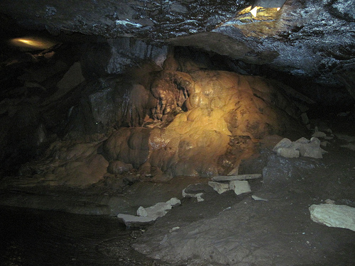
The cave system
developed in Mississippian-age (middle to late, roughly 340–320 million
years ago) carbonate rocks:
St. Louis Limestone and Ste. Genevieve
Limestone primarily.
A key feature is the Lost River Chert Bed
(within the Ste. Genevieve) and the Corydon Chert Member (in the St.
Louis). These bedded chert layers act as perching or semi-impermeable
horizons that influence shallow groundwater flow.
Karst processes
dominate: Rainwater, slightly acidic from dissolved CO₂, percolates
through fractures and dissolves the limestone over time, creating caves,
passages, sinkholes, and underground rivers. The system includes about 7
miles (11+ km) of mapped passages, with potential for more.
Chert
blocks detach from walls as limestone dissolves, lining the floor and
creating backwaters and scalloped features that affect water flow.
Hydrology and the Lost River
The Lost River is a sinking stream
that exemplifies karst hydrology:
It flows above ground in short
sections before disappearing underground.
It enters the cave system,
with one of the largest natural cave entrances in the eastern U.S. (a
dramatic sinkhole/ravine with steep sides, ~100 feet deep).
The river
resurges or continues through the ~7-mile cave system. The drainage
basin covers about 55–85 square miles (143+ km²), flowing generally
northward and contributing to the regional aquifer linked to Mammoth
Cave.
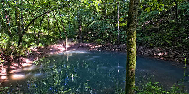
Famous Blue Hole: This is a key feature — a deep, vibrant
blue pool (due to calcite/limestone particles reflecting light) within
the cave or valley. Historically mismeasured as ~437 feet (133 m) deep
(making the short surface river segment the "shortest, deepest river"
per Ripley's Believe It or Not), it is actually only about 15 feet deep
but connects to a larger underground river system that sweeps plumb
lines away. There are typically four blue holes at the site.
Water
temperatures are stable (around 15°C / 59°F in studies), and flow can
vary with rainfall, sometimes flooding higher passages.
Topography and Surface Features
Valley/Sinkhole: A large collapsed
entrance forms a wooded ravine with mesic (moist) forest dominated by
mature oaks (chinkapin, white, black, etc.), tuliptree, sycamore, and
other hardwoods.
Blue holes and springs: Vertical water-filled
sinkholes/caves.
Trails: ~2–3 miles of natural surface paths wind
through the valley, past bluffs, blue holes, and historical sites.
Karst windows and swallets: Areas where surface water sinks directly
into the subsurface.
The topography includes rolling hills,
sinkhole plains, and dissected plateaus typical of the region, with
underground drainage dominating over surface streams.
Human and
Ecological Context
The cave and valley have supported human use for
millennia (Paleo-Indian shelter, Archaic period artifacts) and later
industry (mills, Civil War camps, nightclub). Today, it serves as an
educational site for karst ecology, with boat tours highlighting the
underground river.
The ecosystem includes diverse flora/fauna adapted
to the moist, shaded valley and cave environments. Conservation efforts
focus on water quality, invasive species removal, and stormwater
management to protect the sensitive karst aquifer.
Prehistoric and Native American Use (Paleo-Indian to Archaic Period)
Archaeological evidence from WKU shows human presence dating back about
10,000 years to the end of the last Ice Age (Paleo-Indian period). The
cave and valley offered shelter, reliable water from the blue hole and
river, and food resources in a cooler, wetter climate with evergreen
forests. Nomadic "big game hunters" used Clovis-style spear points to
hunt megafauna like mammoths, mastodons, and ground sloths. They likely
used the site seasonally, especially in winter.
Around 8,000 B.C.,
during the Archaic period, people exploited the environment more
systematically. A rare Dalton point (spear point) found in situ by
anthropologist Jack Schock makes the site significant for studying this
era. Native groups used the area for hunting, shelter, and resources
until around 1,000 B.C. Evidence includes caches of arrowheads and
flint-working debris. Some accounts mention burials or use as a hunting
ground.
Early Settlement and Industrial Era (Late 1700s–1800s)
European-American settlement brought industrial development. Conflicting
reports place the first mill around 1792 (Bowling Green’s founding year)
as a gristmill and sawmill, though other sources date significant
operations later. The cave’s proximity to the Louisville-Nashville
Turnpike made it ideal for commerce.
Mills operated at or near the
entrance:
Early structures inside the cave or under the arched
entrance (one claimed as the only underground water mill in the U.S.).
By 1825, owned by James Skiles; in 1847, a Mr. Shanks added wool
carding.
In the mid-1870s, John L. Row built a more ambitious
three-story mill and distillery above the cave, drilling through bedrock
for power. It operated until 1889, later owned by others.
The last
mill (Robert Crump) burned in 1915.
A 1847 journal entry by
Thomas Kite vividly describes the scene: a deep sink with a full-grown
river flowing into a massive cavern arch, with a gristmill operating
underneath, powered by the water.
Civil War (1861–1865)
The
cave and valley served as a strategic campsite due to reliable water
(one of the few sources south of the Barren River). Confederate forces
occupied Bowling Green from September 1861 to February 1862 and used the
area. Union troops then camped there extensively—nearly 40,000 soldiers
between 1862 and 1865—using it for shelter, training, and water.
Soldiers etched names, ranks, and companies on the walls and ceilings
(some still visible or documented via records); archaeologists have
found Union bullets.
Lore mentions Confederate raider John Hunt
Morgan hiding there after actions like burning a depot, but this is
questionable as Union forces controlled the site at the time. The area
saw control shift between sides.
Outlaw Lore and Transition (Late
1800s–Early 1900s)
In 1869 (or around the late 1860s), the Jesse
James gang is said to have hidden in the cave after robbing the Southern
Deposit Bank in Russellville, Kentucky. This story, while popular for
tourism, has limited verification—some evidence suggests James stayed at
a friend’s house in Bowling Green instead. It became a key part of local
folklore.
Rumors (unproven) persist of bootlegging during
Prohibition.
Cavern Nite Club Era (1930s–Early 1960s)
In 1934,
businessman Jimmy Stewart opened the Cavern Nite Club in the cave mouth,
featuring a stage, bar, and dance floor. Its natural cool temperatures
(a draw before widespread air conditioning) made it popular; Billboard
once called it the only air-conditioned nightclub in the U.S.
Electricity came from a water wheel and generator.
Performers
included Dinah Shore, Francis Craig, and the NBC Orchestra. It operated
until around 1962 (some sources say late 1950s/early 1960s), boosted by
the Dixie Highway (U.S. 31W). The club era ended due to changing
entertainment (FM radio, TV), home air conditioning, and I-65 rerouting
traffic away from the site.
Decline, Dumping Ground, and
Restoration (1960s–1990s)
After closure, the site fell into neglect
and became a dumping ground by the 1980s, accumulating debris.
In
1990, the Friends of Lost River Cave formed as a 501(c)(3) nonprofit to
restore it. They removed over 80 tons of trash. The cave reopened to the
public in 1997. The site is now a 72-acre park with trails, listed on
the National Register of Historic Places. Efforts include removing
invasive species, restoring native vegetation, improving stormwater
filtration via wetlands, and educational programs.
Modern Era and
Tourism
Today, it offers underground boat tours (Kentucky’s only one)
that highlight geology, history, and folklore (Native Americans, mills,
Civil War, Jesse James, nightclub). Walking tours, hiking trails,
events, and educational programs are available. The former nightclub
space serves for events like weddings. WKU and the Friends continue
conservation, research, and public access.
Flora (Plants)
The park spans multiple ecosystems, supporting a
mix of woodland, meadow, prairie, and wetland species. Restoration
focuses on native Kentucky plants to rebuild habitats for pollinators,
birds, insects, and other wildlife.
Woodlands and Ravines (Mesic
Areas):
Large, mature trees (75+ years old) dominate, including
various oaks (chinkapin, white, black, southern red, swamp chestnut),
tuliptree (yellow poplar), black cherry, sycamore, hackberry, black
walnut, eastern red cedar, and osage orange. These provide canopy, mast
(nuts/fruits), and structural habitat.
Meadow and Prairie Restoration
Areas:
Efforts since 2019 have planted and encouraged native forbs,
grasses, and sedges in the karst valley floor. Examples include:
Forbs/Wildflowers: Partridge Pea (seed pods for birds), Great Blue
Lobelia (hummingbirds, bees), Purple Giant Hyssop (bees, fritillaries,
skippers), Culver’s Root (bees, moths), Cliff Goldenrod (fall nectar),
Obedient Plant, Marsh Marigold, Wild Sweet William (Phlox maculata), Joe
Pye Weed, Meadow Blazing Star (Liatris), Cardinal Flower, Tall
Bellflower, Wild Geranium, Virginia Bluebells, Bloodroot, Shooting Star,
Foam Flower, Jacob’s Ladder, Dutchman’s Breeches, Passionflower Vine
(host for butterflies).
Grasses and Sedges: River Oats (caterpillar
host), Virginia Wild Rye (deer cover/food), Little Bluestem, Canada Wild
Rye, Sideoats Grama, various sedges (e.g., Hop Sedge, Palm Sedge,
Cattail Sedge), Fowl Mannagrass (host for skippers and brown
butterflies).
These support pollinators, seed-eaters, and the
food web. A seasonal butterfly habitat (open Memorial Day to Labor Day)
features nectar plants and hosts for species like Monarch (Danaus
plexippus), Painted Lady, Gulf Fritillary, Common Buckeye, Giant
Swallowtail, and Red Admiral.
Wetlands and Aquatic Areas:
Cattails, rushes, and other wetland plants in restored areas; riverbanks
and blue holes support moisture-loving species. Invasive removals (e.g.,
common reed/Phragmites) aid natives.
Overall Notes on Flora:
The
site emphasizes native, regionally appropriate plants for ecological
resilience in karst terrain (thin soils, rapid drainage). Volunteers and
partners like Wild Ones SoKY and Master Gardeners track progress via
BioBlitzes. Spring ephemerals and cool-season species thrive in vernal
pools and shaded areas.
Fauna (Animals)
The diverse
habitats—from surface trails and meadows to the underground
river—support rich wildlife. Over 130 bird species have been documented,
making it an urban nature sanctuary.
Cave-Dwelling
(Troglobitic/Troglophilic) Species:
The underground river and
passages host specialized organisms adapted to darkness:
Blind/White Crayfish: Eyeless or reduced-pigmentation cave crayfish
(likely related to Southern or Mammoth Cave species like Orconectes
spp.). They scavenge in the river and pools; visible on boat tours.
Cave Crickets (e.g., camelback crickets): Common in dark, damp areas;
they feed on organic matter.
Bats: Various species use the cave for
winter hibernation (they depart in summer for foraging). Kentucky caves
often host species like big brown bats, little brown bats, or others
common to the region.
Other potential: Small invertebrates, possibly
salamanders or fish in connected waters (similar to nearby Mammoth Cave
systems, though Lost River is smaller).
Surface Mammals:
White-tailed deer (use meadows/grasses for cover/food), eastern gray
squirrels, raccoons, opossums, rabbits, and others. Larger or less
common: coyotes, possibly foxes. Historical paleo use included megafauna
like mammoths/ground sloths, but modern fauna is typical of Kentucky
woodlands.
Birds:
Diverse due to varied habitats (woods,
meadows, wetlands). Documented via eBird; examples from observations and
site mentions include:
Waterfowl: Mallards (nesting/hatchlings in
wetlands), Canada Goose, Wood Duck.
Songbirds/Raptors: Tufted
Titmouse, Downy Woodpecker, Brown Thrasher, Blue-gray Gnatcatcher,
Ruby-throated Hummingbird, Mourning Dove, Chimney Swift, Broad-winged
Hawk, Cedar Waxwing, Yellow-breasted Chat, and many warblers, vireos,
tanagers, etc. (over 100 species total).
Others: Birds of prey,
woodpeckers, and ground-foragers benefit from restored meadows and
trailside viewing stations.
Insects and Invertebrates:
Key
indicators of meadow health; restoration has boosted populations:
Butterflies/Moths: As noted in the habitat—Monarchs, fritillaries,
swallowtails, etc. Moths like Foot Fan Moth, Ithaca Clearwing.
Others: Bristle flies, Green Crab Spider, Fork-tailed Bush Katydid, bees
(multiple species attracted to hyssop, lobelia, etc.), skippers, syrphid
flies, and caterpillars hosted by grasses/forbs.
Aquatic: Insect
larvae, freshwater shrimp (in wetlands/river), snails.
Amphibians
and Reptiles:
Likely salamanders (in moist areas/caves), frogs/toads
(vernal pools/wetlands), turtles (including mentions of
blind/malnourished ones pre-restoration, now improving), snakes, and
lizards in woodlands/meadows.
Other:
Fish in the Lost River
(surface and possibly cave-adapted), small mammals, and pollinators. The
site supports a recovering food web, with insects as a foundation for
birds, bats, and others.
Mill Era and Early Settler Legends
In the late 1700s–1800s, the
cave supported early industry. Mills (grist, saw, wool carding, and even
a distillery) operated at or inside the entrance, harnessing the river’s
power. Conflicting accounts place the first mill around 1792 (when
Bowling Green was founded) or later. One notable operator was Mr. Shanks
(or similar spelling) in the 1790s–1840s.
Shanks’ Buried Treasure
Legend: Local lore claims Shanks buried a wooden box full of money or
valuables near the mill or cave. He reportedly died suddenly, and the
treasure was never officially recovered — or if it was, the finder kept
quiet. This fits classic “lost treasure” motifs tied to early frontier
mills and sudden deaths.
Mills burned or were destroyed by flood/fire
multiple times (e.g., one in 1915), adding to tales of misfortune or
mysterious destruction at the site.
Civil War Stories and Soldier
Lore
During the Civil War, the valley and cave served as a campground
for both Confederate (1861) and Union forces (after February 1862), with
up to 40,000 soldiers in the area at times. Soldiers left signatures,
ranks, and bullet evidence on walls/ceilings.
Drowned Soldiers and
Morgue/Purgatory Legends: Tour guides have long shared stories of
soldiers drowning in the blue holes while exploring. The cave was
sometimes called “Dead Man’s Cave” or “Purgatory Cave.” Speculation
persists that it served as an informal burying ground or morgue. Some
darker tales suggest bodies were used for early medical dissection (with
whiskey bribes to condemned men), as the remote cave provided secrecy in
an era when such practices were taboo.
John Hunt Morgan Hideout:
Confederate raider John Hunt Morgan is said to have hidden in the cave
after burning a depot at South Union. This is widely considered
low-credibility folklore, as Union troops were camped there.
Jesse James Outlaw Hideout Legend
One of the most enduring and
promoted local legends is that outlaw Jesse James and his gang used the
cave as a hideout after robbing the Southern Deposit Bank in
Russellville, Kentucky (around 1868–1869). This story enhanced
1930s–1960s cave tours and the nightclub era. While colorful and tied to
the site’s tourism, it remains unproven folklore that adds romantic Wild
West flair.
Blue Hole Folklore and Reflections
The four blue
holes each carry their own stories. A romantic legend tells of young
women gazing into the reflective waters hoping to see the face of their
future husband — a folk divination practice linked to the mystical
qualities of the pools.
Cavern Nite Club Era and Ghostly
Apparitions
In 1933–early 1960s, the cave mouth hosted the popular
Cavern Nite Club (also called Underground Nite Club), a cool (57°F)
swing/jazz venue with a dance floor, bar, and big-name performers like
Dinah Shore and Francis Craig. It was marketed with the Jesse James
legend and drew tourists via the Dixie Highway.
Haunted Dance Floor
Lore: Staff and visitors have reported ghostly figures gliding across
the empty dance floor after hours, including a woman in a long white
dress. These tales gained traction with the site’s later use as a dump
(1970s–80s) and its revival. Halloween events like the Witchcraft Ball
and Goblin Gala in the 1990s leaned into the spooky atmosphere.
Modern “Lost Tales of the Underground” boat tours highlight ghostly lore
and dark history (Civil War deaths, mysterious mill fires, etc.) without
heavy jump-scares.