Location: Hot Springs, SD Map
Area: 28,295 acres (114 km²)
Official site
Wind Cave National Park in southwestern South Dakota is one of the
lesser-visited but highly rewarding U.S. National Parks. It features one
of the world’s longest and most complex cave systems (over 150+ miles
explored, with boxwork formations unique on a large scale) alongside
scenic mixed-grass prairie, ponderosa pine forests, and abundant
wildlife like bison, pronghorn, elk, prairie dogs, and more.
The park
offers a strong “two-in-one” experience: underground cave tours and
above-ground hiking, wildlife viewing, and scenic drives. No entrance
fee applies to the park itself (only cave tours have fees), making it a
great stop on Black Hills itineraries near Custer State Park, Jewel
Cave, Mount Rushmore, and Hot Springs.
Best Time to Visit
Spring (late May–early June) and Fall
(September–October): Ideal for milder temperatures, fewer crowds,
excellent wildlife viewing (e.g., elk bugling in fall), and pleasant
hiking. Wildflowers bloom in spring.
Summer (June–August): Peak
season with full tour schedules and warm weather for surface activities,
but expect crowds, heat (often >80°F/27°C), thunderstorms, and sold-out
tours. Cave remains a cool 54°F (12°C) year-round.
Winter: Quieter
with limited tours/schedules, possible snow/road closures, but beautiful
for those prepared for cold. Cave tours run year-round with adjustments.
Check current conditions, road status, and alerts on the NPS website, as
weather in the region can be unpredictable (thunderstorms, hail, snow).
Getting There and Practical Info
Location: 26611 US Highway 385,
Hot Springs, SD 57747 (about 11 miles north of Hot Springs, ~50 minutes
from Rapid City).
Directions: Use US 385; avoid relying solely on GPS
for the visitor center—it can misroute. Coordinates approx. N43°33'22"
W103°28'38". Scenic routes via Black Hills or from Custer State Park (SD
87) are available. No public transportation. Nearest airport: Rapid
City.
Visitor Center: Hub for tickets, info, exhibits, film,
bookstore, and limited vending. Hours vary seasonally (e.g., 8 AM–6 PM
in peak summer). Arrive early.
Cell Service/Internet: Limited in the
park—download maps/offline content in advance. NPS app is useful.
No
services inside the park for gas, groceries, or lodging (except
campground). Head to Hot Springs (~12 miles south) or Custer (~20–25
miles north).
Cave Tours: The Highlight
All cave access
requires a ranger-guided tour—no self-guided options. Tours sell out
fast, especially in summer (often by midday or earlier). Book via
Recreation.gov in advance (highly recommended) or arrive early for
same-day tickets. Only credit/debit cards accepted.
Key Tips:
Cave
is ~54°F (12°C) and damp/slippery—wear layers, sturdy closed-toe
non-slip shoes (no sandals on most tours), jacket/sweater. No restrooms
underground.
Prohibited: Backpacks/purses/bags, food/drinks (incl.
water/gum), walking sticks/tripods, touching formations/walls, pets
(service animals on select tours). Photography allowed on standard tours
(no flash tripods).
Arrive 30+ minutes early. Tours involve stairs
(some strenuous); not ideal for claustrophobia, mobility issues,
heart/respiratory conditions, etc.
Accessibility: Limited
wheelchair-accessible tours via elevator—call ahead.
Main Tours
(schedules vary seasonally; check NPS/Recreation.gov for exact times and
availability):
Garden of Eden: Shortest/easiest (~1/3 mile, ~1 hour,
~150 stairs). Good intro with boxwork.
Natural Entrance: Popular
(~2/3 mile, ~1.25 hours, ~300 stairs, starts at natural entrance).
Fairgrounds: Longer/more strenuous (~1.5+ hours, more stairs/terrain).
Impressive rooms.
Candlelight/Wild Cave: Adventurous (lanterns or
helmets; crawling, tighter spaces)—for fit visitors seeking challenge.
Fees vary (adults ~$7–$23+ for standard; higher for wild; discounts
for seniors/youth; under 6 free on some). Check current on NPS site.
Above-Ground Activities
Hiking: 30+ miles of trails through
prairie and forest. Easy: Prairie Vista (1 mi loop from visitor center),
Elk Mountain (1 mi, pet-friendly), Rankin Ridge (1 mi to views).
Moderate/strenuous options include Lookout Point, Boland Ridge, Highland
Creek. Open-hike policy allows off-trail exploration (bring map, water,
be wildlife-aware).
Wildlife Viewing & Scenic Drives: Bison,
pronghorn, elk common—stay 25+ yards away (bison especially
unpredictable; more aggressive in calving/rut). Drive SD 87/US 385.
Prairie dog towns.
Camping: Elk Mountain Campground (62 sites,
year-round; reservable peak season ~$24/night; water/flush toilets in
summer). Backcountry camping (free permit).
Other: Ranger programs,
picnicking, Junior Ranger for kids.
Pet Policy: Dogs on leash
(max 6 ft) allowed in campground, visitor center area, and two trails
(Prairie Vista, Elk Mountain). Not in cave, backcountry, or most trails.
Never leave unattended (incl. in cars). Clean up after them.
Safety and Preparation
Wildlife: Keep distance; bison can charge.
Ticks common—check yourself/pets. No feeding animals.
Weather/Hiking:
Carry water (treat backcountry sources), layers, sun protection, map.
Thunderstorms common in summer. Slippery cave surfaces.
Leave No
Trace: Pack out trash; stay on trails where required; no collecting
resources.
Health: Hydrate, pace yourself on tours/hikes. Limited
medical services—nearest in Hot Springs/Custer.
Prehistoric and Indigenous History
The cave’s limestone (Pahasapa
Limestone) formed around 350 million years ago during the Mississippian
Period in a shallow inland sea, where marine life remains created the
rock layers. Cave passages began forming later, around 320 million years
ago, as acidic groundwater dissolved the limestone. The cave is a
“breathing cave,” with air flowing in or out due to barometric pressure
differences, which gave it its name.
Indigenous peoples, particularly
the Lakota (Sioux) and Cheyenne, and at least 20 associated tribes, have
long known of the area. They camped nearby, as evidenced by tipi rings,
and viewed the cave (called Maka Oniye or “breathing earth,” or Washun
Niya) as sacred. It features prominently in Lakota oral traditions as
the site of emergence from the underworld.
In one version of the
Lakota Emergence Story (variations exist across bands), people
originally lived underground in the spirit lodge. A trickster figure
(Iktomi) and Anog-Ite lured some to the surface with gifts, leading to
hardship in the new world. The Creator transformed some into bison and
later guided the people (led by Tokahe, “The First One”) to emerge from
Wind Cave. The entrance was then shrunk as a reminder of their origins.
Bison and humans are deeply linked in this narrative, with the cave
symbolizing the portal between worlds.
The Black Hills (Pahasapa)
were vital hunting and resource grounds. Treaties like those of Fort
Laramie (1851 and 1868) were undermined by gold rushes and settlement,
leading to dispossession of Lakota lands in the late 19th century.
Euro-American Discovery and Early Exploration (1881–1890s)
The
first documented discovery by white Americans occurred in 1881. Brothers
Tom and Jesse Bingham, while hunting, heard a loud whistling noise from
a small (about 10x14-inch) hole. The wind was strong enough to blow off
Tom’s hat; on a return visit, the wind reversed and sucked a hat inside.
Charlie Crary of Custer, SD, is credited as the first known explorer,
squeezing through the natural entrance with candles and string for
navigation. Early visitors faced challenges like narrow passages and
getting lost. The Binghams enlarged the entrance and built a cabin over
it.
In 1889–1890, the South Dakota Mining Company claimed the site
(hoping for minerals) and hired Jesse D. McDonald to manage it.
McDonald’s family, especially his son Alvin McDonald (a teenager at the
time), became central to exploration and development. Alvin explored
extensively, mapped passages, named rooms, and kept a detailed diary
from 1891 until his death in 1893 from typhoid fever. He expressed awe
at the cave’s vastness, once noting he had “given up the idea of finding
the end.” His writings provide invaluable insights into early
exploration.
Tours began around 1890–1892, with visitors using
candles. The McDonalds partnered with the Stabler family (John Stabler
and his children), who built a hotel, promoted the site aggressively
(including stunts like a fake “petrified man” and mind-reading events),
and sold specimens. Ownership disputes and lawsuits arose between the
Mining Company, McDonalds, and Stablers.
Path to National Park
Status (Late 1890s–1903)
As commercial interests clashed and the
cave’s uniqueness became clear, calls grew to protect it. In 1899–1900,
land office decisions favored reserving it as a public resort. The land
was withdrawn from settlement in 1900. Captain Seth Bullock (famous
lawman) served as supervisor in 1902.
Congress passed the bill, and
President Theodore Roosevelt signed it into law on January 9, 1903,
establishing Wind Cave National Park. It was the first cave designated
as a national park worldwide. Early management focused on tourism while
addressing development pressures.
20th Century Development and
Conservation
The Civilian Conservation Corps (CCC) worked in the park
during the 1930s, building infrastructure like trails and facilities.
Exploration continued: By the mid-20th century, more passages were
mapped. Notable explorers included Jan and Herb Conn in the 1960s.
Today, the cave has over 168 miles (270 km) of surveyed passages (as of
recent counts), making it one of the world’s longest and densest cave
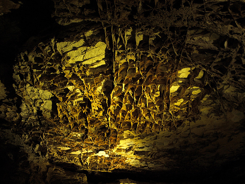
systems, though much remains unexplored. It is famous for rare boxwork
(calcite fins forming honeycomb-like structures; ~95% of the world’s
known examples are here), frostwork, popcorn, and other speleothems.
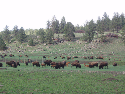
Above ground, the park became a key site for wildlife conservation. The
Wind Cave bison herd, one of the few genetically pure free-roaming herds
in North America, was reintroduced and has thrived. Other species like
black-footed ferrets and prairie dogs are present.
The park expanded
its focus on cultural resources, consulting with associated tribes and
preserving historic sites like homesteads. Modern management balances
cave protection (fragile formations), prairie restoration, and public
access via guided tours.
Surface Topography and Landscape
The park sits on the southeastern
flank of the Black Hills, a domal uplift (Laramide Orogeny, ~60–50
million years ago) that exposes a bullseye pattern of rock layers around
a Precambrian core. The terrain is gently rolling to moderately hilly,
with elevations generally ranging from about 3,800 to over 4,500 feet
(average around 4,300 feet / 1,310 m). It forms a transitional “bay”
open to the surrounding plains through gaps in the Dakota Sandstone
Hogback Ridge (e.g., Buffalo Gap to the east and Cascade Springs area to
the south).
Key surface features include:
Mixed-grass prairie
(dominant, ~63% of the park): Expanses of rolling grasslands with native
species supporting bison, pronghorn, prairie dogs, and other wildlife.
This is one of the largest remaining intact mixed-grass prairies in the
U.S.
Ponderosa pine forests (~29%): Concentrated on higher ridges and
hills, blending eastern and western biome elements.
Riparian zones
and canyons: Drainages like Beaver Creek, Highland Creek, Cold Spring
Creek, Wind Cave Canyon, and Fuson Canyon. Some streams are sinking
streams that lose flow to the subsurface karst system (e.g., Beaver and
Highland Creeks lose millions of gallons daily).
Hills, ridges, and
valleys: Shaped by differential erosion—more resistant rocks (e.g.,
sandstones, pegmatites) form ridges; softer shales form valleys. The
landscape includes scattered sinkholes, blowholes (small openings
responding to barometric pressure), rockshelters, and springs (over 90
in the park, though not all directly tied to the main cave).
The
surface appears deceptively flat or gently undulating prairie in places,
masking the vast cave network below.
Subsurface Geology and Cave
System
Wind Cave is a world-class karst system developed primarily in
the Mississippian Pahasapa Limestone (also called Madison Limestone,
~320–360 million years old). This limestone formed from marine sediments
(shell fragments, calcium carbonate) in a warm shallow sea, with
interbedded gypsum/anhydrite from evaporative periods.
Formation
History
Early stages (~320+ million years ago): After sea retreat,
acidic groundwater dissolved limestone along fractures, creating initial
passages and paleokarst features (sinkholes, fissures). Gypsum in cracks
influenced chemistry.
Later development: Multiple marine
transgressions/regressions deposited overlying layers (Minnelusa
Formation, Opeche Shale, Minnekahta Limestone, Spearfish Formation,
etc.). Laramide uplift (~60–50 Ma) fractured rocks, lowered the water
table, and allowed further dissolution and drainage. The cave has
multiple levels (up to 3–5 within ~250 vertical feet) forming a dense,
rectilinear maze pattern—one of the most complex known.
Current
status: Over 168 miles (270+ km) of explored passages (as of recent
data; 4th–6th longest cave globally, 3rd in the U.S.), but only a
fraction of the total system. It connects to deep aquifers (e.g.,
Madison Aquifer) with underground lakes in lower levels. The cave
“breathes” due to barometric pressure differences, which named it (air
rushes in/out of the small natural entrance).
The cave is
relatively dry compared to others, limiting classic dripstone
(stalactites/stalagmites are rare) but favoring unique speleothems.
Iconic Features
Boxwork: The park’s hallmark—thin, honeycomb-like
calcite blades/fins protruding from walls and ceilings. It comprises
~95% of the world’s known examples. Formed when calcite filled
fractures; surrounding limestone dissolved away, leaving the resistant
structure.
Other formations: Frostwork (aragonite needles), cave
popcorn, helictite bushes, dogtooth spar, gypsum crystals, flowstone,
and calcite rafts.
Minerals and complexity: Includes quartz,
paleofills (ancient sediments), and a highly specialized ecosystem.
There are dozens of other smaller caves in the park.
Broader
Geological Context
Exposed rocks in the park span ~2 billion years:
Precambrian (northwest): Schists and pegmatites (large crystals of
quartz, feldspar, mica, tourmaline) from the Black Hills core.
Paleozoic/Mesozoic sedimentary layers: Tilted and eroded, dipping away
from the uplift center.
Karst landscape: Sinkholes, sinking streams,
springs, and blowholes are classic surface expressions of the soluble
limestone bedrock.
Climate and Environmental Influences
The
area has a continental climate with cold winters, warm summers, and
variable precipitation. Rapid barometric changes enhance the cave’s
“breathing.” Climate change projections include warmer/drier conditions
affecting prairie and forest ecosystems.
The park’s geography
supports high biodiversity as an ecotone (prairie-forest transition),
with free-roaming bison, elk, pronghorn, prairie dogs, and more.
Vegetation is ~63% prairie, 29% forest, 7% shrubland.