Location: Upper Peninsula Map
Porcupine Mountains Wilderness State Park (often called "the
Porkies") is Michigan’s largest state park, spanning about 60,000
acres in the western Upper Peninsula near Ontonagon. It features
dramatic old-growth hardwood-hemlock forests (one of the largest in
the Great Lakes region), rugged ridges, roaring waterfalls, Lake
Superior shoreline, rivers, and scenic overlooks.
It is a premier
destination for hiking, backpacking, camping, waterfalls, fishing,
paddling, and fall colors. The terrain offers a mix of
beginner-friendly and more challenging options, with significant
elevation changes (up to ~1,950 ft at Summit Peak) compared to
flatter areas of Michigan.
Getting There and Practical Basics
Location: 33303 Headquarters
Road, Ontonagon, MI 49953. It is remote; Ontonagon is ~20 miles east,
while Ironwood and Houghton are about an hour away (with limited
commercial airports).
Vehicle Entry: A Michigan Recreation Passport
is required. As of 2026, non-residents pay ~$42 for an annual pass or
$11+ daily (prices can vary slightly with adjustments; confirm on-site
or via Michigan DNR). Michigan residents have lower rates via vehicle
registration. Buy at the Visitor Center, online, or select locations.
Visitor Center: Newly renovated, open mid-May to mid-October (typically
8 a.m.–8 p.m. ET). It offers exhibits, a multimedia show, trail info,
Wi-Fi, gift shop, restrooms, and staff advice. Great starting point.
Cell Service and Emergencies: Spotty/inconsistent, especially off peaks.
Nearest hospital (Aspirus Ironwood) is up to an hour away. Carry a map,
tell someone your plans, and call 911 in emergencies.
Roads and
Access: Some roads (e.g., parts of M-107 and South Boundary Road) close
in winter (Dec. 1 onward) for snowmobiling and reopen when safe. Check
conditions.
Best Time to Visit
Summer (June–August): Warm days
(mid-70s°F highs), but buggy (blackflies, mosquitoes) near Lake
Superior. Good for swimming, paddling, and waterfalls.
Fall (Late
August–October): Often ideal—fewer bugs/crowds, stunning foliage (peaks
early–mid October), cooler temps. Watch for early snow. Popular for
hiking and photography.
Spring: Thawing waterfalls, fewer crowds, but
muddy/wet trails and variable weather.
Winter: Snowshoeing,
cross-country skiing (42 km groomed trails), snowmobiling. Limited
access; prepare for cold.
Must-See Attractions and Hiking Tips
The park has ~90 miles of trails, including segments of the North
Country Trail and Iron Belle Trail. Trails can be rooty, rocky, and have
elevation; wear sturdy boots and consider trekking poles. Download maps
from the Michigan DNR site or Visitor Center.
Top Highlights:
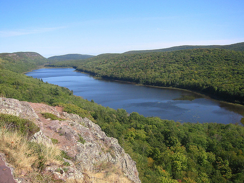
Lake of the Clouds Overlook (ADA-accessible): Iconic panoramic views of
the lake, valley, and ridges. Short boardwalk from parking. Start here
for sunrise or Escarpment Trail.
Escarpment Trail: One of the best in
the Midwest. Out-and-back from Lake of the Clouds with continuous ridge
views. Hike as far as you like (moderate-strenuous).
Presque Isle
River Waterfalls Loop (~2 miles, beginner-friendly with boardwalks):
Three main waterfalls (Nawadaha, Manabezho, etc.) plus cascades. Strong
currents—no swimming. Accessible overlook available.
Summit Peak
Observation Tower: Highest point; 360° views, including Lake Superior
and sometimes Apostle Islands.
Big Carp River Trail and Mirror Lake:
Scenic river hikes, fords, great campsites, and swimming spots. Good for
day hikes or loops.
Other Waterfalls: Greenstone Falls, Overlooked
Falls, etc.
Lake Superior Shoreline: Beaches, Union Bay
paddling/swimming, boat launches.
Additional: Disc golf (18-hole,
free), fishing (brook trout; special regs at Lake of the Clouds), winter
sports.
Hiking Tips:
Start early for popular spots to beat
crowds.
Pack layers, rain gear, sturdy footwear, headlamp, first aid,
water filter, and bear precautions (food storage).
Pack out all
trash, including toilet paper (Leave No Trace; catholes for waste 200+
ft from water/trails/campsites).
Check trail conditions at the
Visitor Center.
Camping and Overnight
Union Bay Modern
Campground: ~100 sites (electric, modern restrooms/showers, sanitation
station, playground, store, boat launch, beach access). Reservations
recommended via midnrreservations.com.
Backcountry Camping: Dispersed
sites along trails (reservations required up to 6 months ahead).
Stunning options near rivers/lakes. Register and follow wilderness
rules.
Other: Yurts, rustic options, group sites. Winter dispersed
camping available.
Bear Safety: Store food/scented items properly
(vehicle or bear bags). Black bears are present.
Other Activities
Paddling/Fishing: Kayak/canoe rentals (Simple Adventures near Union
Bay). Lake Superior paddling; river fishing.
Winter: Ski the Porkies
complex, snowshoeing, dog sledding.
Nearby: Bond Falls, Black River
Scenic Byway waterfalls, Ontonagon area.
What to Pack and Safety
Tips
Essentials: Layers (cool nights even in summer), rain jacket,
sturdy boots, bug spray/netting (peak season), binoculars, map/GPS,
water purification, headlamp, trekking poles, sun protection.
Food/Water: Limited services—stock up in Ontonagon. Filter or treat
water.
Wildlife/Weather: Prepare for variable Lake
Superior-influenced weather (wind, fog, sudden changes). Ticks, bugs,
and slippery rocks near falls. No drones in wilderness areas.
Accessibility: Some overlooks and trails are ADA-friendly; check
specifics.
Indigenous History and Naming
The cultural history begins with
Native American peoples, particularly the Ojibwa (also known as Chippewa
or Anishinaabe). They named the mountains Kag-wadjiw or similar, meaning
something like “place of the porcupine” or “crouching porcupine.” From
villages near the Ontonagon River’s mouth, the range’s silhouette
against the sunset resembled a crouched woodland porcupine.
Archaeological evidence shows human habitation in the broader region
dating back about 8,000 years. Indigenous peoples used the area for
hunting, fishing, gathering, and early copper extraction (native copper
was worked by ancient peoples in the Keweenaw region). The Ojibwe were
the primary inhabitants in more recent centuries.
Geology and
Ancient Origins
The Porcupine Mountains are geologically ancient —
remnants of an old stratovolcano or related to the Midcontinent Rift
System, with bedrock around 1.1–2 billion years old in some accounts.
They feature a prominent basalt and conglomerate escarpment parallel to
Lake Superior, overlooking Lake of the Clouds, and are part of the same
copper-bearing geology as the Keweenaw Peninsula. Summit Peak reaches
about 1,958 feet (the highest point). Rivers, waterfalls (including on
the Presque Isle River), swamps, and lakes fill the terrain.
European Exploration, Fur Trade, and Early Settlement
Europeans
arrived primarily for furs in the 17th–18th centuries, with French and
later British traders active in the Lake Superior region. Systematic
Euro-American development accelerated in the 19th century.
Copper
Mining Boom (Mid-19th Century Onward)
The area saw significant copper
prospecting and mining starting in the 1840s, part of the broader
Keweenaw copper rush. Prospectors arrived as early as 1844; by 1845,
operations like the LaFayette and Union mines were active. At least 53
mining permits were issued. Mines included the Nonesuch Mine (operated
sporadically 1867–1912) and others like Union Mine. Machinery, rock
dumps, and adits remain as remnants.
The nearby White Pine Mine (just
outside the park boundary) had earlier operations (1881 onward) and
major production from the 1950s–1980s. Mining was challenging due to the
rugged terrain and inconsistent ore; most ventures in the Porkies were
short-lived or unprofitable. The park is a cooperating unit of Keweenaw
National Historical Park due to this shared copper heritage.
Logging, Trapping, and Early 20th Century
Limited logging occurred,
notably around 1916, targeting pine and cedar. By the 1930s, only a few
trappers remained active. The old-growth stands largely survived due to
the difficult access and lower economic viability compared to
surrounding areas.
The Great Depression and World Wars influenced the
region, with some resource extraction tied to wartime needs, but the
core wilderness persisted.
Preservation and Establishment as a
State Park (1940s)
In the early 1940s, loggers threatened the
remaining virgin timber. Conservationists, including the legendary Aldo
Leopold, advocated strongly for protection. Leopold’s 1942 essay “The
Last Stand” (or similar writings) highlighted the “Great Uncut”
old-growth maple-hemlock forest and urged preservation amid wartime wood
demands that had already cleared 30,000 acres nearby.
The Michigan
legislature established Porcupine Mountains State Park in 1945 (some
sources note planning or dedication around 1944), dedicating ~60,000
acres primarily to safeguard the old-growth forest — one of the last
extensive unspoiled wilderness areas in the Midwest. This was a citizen-
and state-driven effort after national park proposals in the 1930s–1940s
were sidelined by World War II.
Facilities like the Kaug Wudjoo Lodge
(Ojibwa for “place of the crouching porcupine”) were built soon after,
originally as the park manager’s residence.
Later Designations
and Modern Era
In 1972, Michigan’s Wilderness and Natural Areas Act
redesignated it as Porcupine Mountains Wilderness State Park,
emphasizing its wilderness character.
It was designated a U.S.
National Natural Landmark in 1984 for its outstanding geological and
ecological features.
Today, the park offers extensive trails
(including portions of the North Country Trail), backcountry camping,
rustic cabins, modern campgrounds, skiing (Porcupine Mountains Ski
Area), and interpretive programs on history, wildlife, and ecology. It
attracts hundreds of thousands of visitors annually for hiking,
waterfalls, Lake of the Clouds overlook, and more.
The park continues
to balance recreation with preservation. Ongoing concerns include
potential nearby mining threats (e.g., proposed Copperwood Mine), which
have sparked conservation efforts to protect water quality, trails, and
wilderness values near Lake Superior.
Location and Regional Context
The park sits along the southern
shore of Lake Superior in a remote, rugged part of the Upper Peninsula.
Its western edge includes the Presque Isle River area, while the eastern
parts extend toward Union Bay and Silver City. The terrain forms a
prominent topographic feature visible from afar, rising sharply from the
lake. It is part of the broader Keweenaw Peninsula copper district and
cooperates with Keweenaw National Historical Park due to its mining
history.
The park protects one of the largest remaining tracts of
old-growth northern hardwood-hemlock forest in the Midwest (around
31,000–35,000 acres of virgin timber), contributing to its status as a
National Natural Landmark (designated 1984).
Topography and Major
Features
The Porkies are not true high mountains by Western U.S.
standards but represent a significant range of small, ancient mountains
with parallel ridges running roughly east-west, parallel to Lake
Superior. Key elevations:
Summit Peak: The highest point at 1,958
feet (597 m), offering panoramic views.
Other high points reach
around 1,600–1,850 feet.
The park rises 1,000+ feet above Lake
Superior in places.
Major ridges and escarpments dominate the
landscape:
A prominent basalt and conglomerate escarpment runs
parallel to the Lake Superior shoreline. This steep bluff overlooks Lake
of the Clouds and forms dramatic overlooks (e.g., along the Escarpment
Trail).
A second inland ridge lies across the valley from the first,
with Summit Peak as its high point.
Between ridges lie valleys,
rivers, swamps, lakes, and dense forests.
Lake of the Clouds is
the park’s iconic centerpiece: a scenic glacial lake nestled in a high
valley between two ridges at about 1,076–1,500 feet elevation. It is fed
by snowmelt and runoff, creating mirror-like reflections of surrounding
peaks and forests, especially striking in autumn.
Other notable
features include:
Presque Isle River corridor (western park):
Features multiple waterfalls (e.g., Manabezho, Manido, Nawadaha) with
accessible loops, boardwalks, and stairs.
Numerous smaller lakes,
rivers (e.g., Carp River, Big Iron River), streams, and swamps.
Rocky
Lake Superior shoreline (about 1.6 miles at Union Bay) with beaches,
bluffs, and boat accesses.
The topography creates a "continental
divide" effect, with waters south of the park draining toward the Gulf
of Mexico via the Mississippi system, while northern waters flow into
Lake Superior and the Great Lakes-St. Lawrence system.
Geology
The Porcupine Mountains are among the oldest mountain remnants in the
United States, shaped by events over a billion years ago during the
Mesoproterozoic era as part of the Midcontinent Rift System (a failed
attempt at continental rifting).
They consist of eroded remnants
of an anticline (upward fold) with faulting, particularly on the
southern overturned limb.
Rocks include thick sequences of basalt
lava flows, andesite, rhyolite, conglomerate, and sedimentary layers
from the Keweenawan Supergroup (copper-bearing bedrock shared with the
Keweenaw Peninsula).
Glaciers during the Pleistocene scoured the
landscape, leaving polished bedrock, lakes, and valleys.
Historical
copper mining (e.g., Nonesuch Mine) occurred in the 19th–early 20th
century.
The escarpment is a striking example of tilted bedrock
layers forming high bluffs. Structural relief between the anticline
crest and nearby synclines is significant (8,000+ feet).
Hydrology and Water Features
Lake Superior influence: The park has
direct shoreline access and is shaped by the lake’s massive presence.
Rivers and streams drain the ridges, creating numerous waterfalls and
rapids. The Presque Isle River is especially scenic.
Inland lakes
like Lake of the Clouds and Mirror Lake sit in high valleys.
Abundant
wetlands, bogs, and beaver-influenced areas. Natural brook trout habitat
is common.
Climate and Weather
The Porkies experience a humid
continental climate with strong lake-effect influences from Lake
Superior:
Heavy snowfall: Annual totals often exceed 200–300
inches (510–760+ cm) in higher elevations due to lake-effect snow,
making it one of the snowiest spots in the Midwest.
Cool summers and
cold winters.
Proximity to the lake moderates temperatures but
enhances precipitation and fog.
This supports lush forests and
winter recreation (skiing, snowmobiling).
Human and Recreational
Geography
Over 90 miles of hiking trails (including the North Country
Trail) traverse the rugged terrain, from easy overlooks to challenging
backcountry routes. The Escarpment Trail offers some of Michigan’s most
scenic vistas.
Campgrounds (e.g., Union Bay modern, Presque Isle
rustic), backcountry sites, and facilities are integrated into the
landscape while preserving wilderness character. The park balances
protection of its ancient geology and forests with recreation.
Flora (Plants and Trees)
The dominant vegetation is old-growth
northern hardwood forest, with sugar maple, American basswood, eastern
hemlock, and yellow birch as the most abundant canopy trees. These
create dense, multi-layered canopies that support a rich understory.
Mountain maple is common in the understory.
Conifers and mixed
stands: Eastern hemlock dominates in lower, moister areas and mixes with
hardwoods. Scattered old-growth white pine appears in some spots. Along
rocky escarpments and shorelines: northern white cedar, common juniper,
red pine, and pin oak.
Deciduous and successional trees: Aspen and
birch forests in disturbed or regenerating areas; thimbleberry bushes
near streams.
Understory and ground layer: Wintergreen, bunchberry,
partridgeberry, hepatica, jack-in-the-pulpit, trailing arbutus, spotted
Joe-Pye weed, and various ferns (e.g., cinnamon fern). Lichens, mosses,
and fungi thrive on dead wood and stumps.
Special concern/rare
plants: Small blue-eyed Mary, ram's head lady's slipper, Hooker's
fairy-bells, slender cliff brake, and male fern. Wildflowers bloom
seasonally, with spring ephemerals and summer blooms along trails.
The park's heavy lake-effect snow and varied topography (from Lake
Superior shoreline to higher ridges like Summit Peak at ~1,958 ft)
create microhabitats, from moist river corridors to drier cliffs. Fall
colors from maples and birches are spectacular.
Fauna (Animals)
The park supports a full suite of northern forest, wetland, and
lakeshore wildlife, including large mammals, predators, birds, and
smaller species. Many are elusive due to the dense cover, but trails,
overlooks (e.g., Escarpment, Lake of the Clouds), and dawn/dusk viewing
improve chances.
Mammals
Large herbivores: White-tailed deer
(abundant, often seen near trails, meadows, and roadsides); moose (less
common, in marshy areas like Mirror Lake and alder swales); occasional
porcupines (the park's namesake, often spotted napping in trees or on
the ground at night).
Carnivores and omnivores: Black bears (stable
population, active in berry-rich areas and woods—secure food properly);
gray wolves (elusive, heard howling or via tracks); coyotes, red and
gray foxes; bobcats, lynx; fishers, martens, mink.
Aquatic/semi-aquatic: North American river otters (along rivers and
falls like Presque Isle); beavers (dams and lodges common, especially
Little Carp River and Mirror Lake).
Smaller mammals: Snowshoe hares,
red squirrels (common and active), striped skunks, hares.
Birds
Diverse due to varied habitats and migration corridors. Highlights
include:
Raptors: Bald eagles (nesting pairs, often over
escarpments and Lake Superior); peregrine falcons, merlins, broad-winged
hawks, ospreys.
Forest birds: Pileated woodpeckers (noisy and
striking), barred owls (heard at night), various warblers (e.g.,
black-throated green, Blackburnian), blue jays, winter wrens, cedar
waxwings, Swainson's thrush.
Waterbirds and others: Common loons (on
lakes and ponds), great blue herons, American bitterns, whip-poor-wills.
Nearly 400 bird species recorded in the broader UP, with hotspots at
Lake of the Clouds and river corridors.
Other Wildlife
Reptiles and amphibians: Wood turtle (special concern); various snakes,
frogs, and salamanders in wetlands and streams.
Fish: Brook trout in
rivers and streams (natural habitat); fishing opportunities in inland
lakes with special regulations (e.g., Lake of the Clouds).
Insects
and invertebrates: Dragonflies, stoneflies, horn-tails, giant ichneumon
wasps; biting insects like stable flies peak in late spring/early
summer.
Wildlife viewing tips: Use the 90+ miles of trails (e.g.,
Big Carp/Little Carp Rivers, Escarpment) for best chances. Dawn/dusk and
quieter weekdays favor sightings. Respect wildlife—leash dogs, secure
food, and maintain distance (especially from moose and bears). Many
species are more often detected by signs (tracks, scat, calls, browse)
than direct views.