Location: New Hampshire, Maine Map
White Mountain Headquarters
(603) 447 5449
Warning:
Mt.
Washington recorded highest velocity of winds on April 12th, 1934 at
231 mph. Temperatures often drop to low 50's even in summer. History
recorded over 100 fatalities. Wear worm clothes and expect rough
weathers at the summit.
The White Mountain National Forest (WMNF) is a federally managed forest located in the White Mountains region of the northeastern United States. It spans primarily across New Hampshire, with a small portion (about 5.65%) extending into western Maine. The forest covers a total area of approximately 750,852 acres (about 3,038.59 km² or 1,225 square miles), making it the only national forest in either New Hampshire or Maine and the most eastern national forest in the United States. In New Hampshire, it occupies parts of Grafton, Coos, and Carroll counties, while in Maine, it includes sections of Oxford County. The WMNF is divided into three discontinuous sections, separated by major transportation corridors such as Interstate 93 and U.S. Route 2, with notable valleys like Franconia Notch creating natural divisions. This vast area encompasses a diverse landscape of mountainous hardwood forests, alpine peaks, clear lakes, streams, and rugged wilderness, serving as a refuge for urban visitors and locals while protecting unique natural features.
These offices provide visitor information, recreation guidance,
permits, and administrative support for the forest's districts.
Supervisor's Office (Forest Headquarters)
Located at 71 White
Mountain Drive, Campton, NH 03223 (updated primary headquarters; older
references to 719 N Main Street, Laconia, NH may reflect a previous or
satellite location).
Phone: +1 603-536-6100 (main), TTY: 711 (or
older +1 603 528-8721 / +1 603 528-8722 for legacy contact). Fax: +1 603
528-8783 (if applicable).
Email: r9_whitemtn_info@fs.fed.us (general
inquiries).
This central office handles overall forest management,
visitor services, accessible restrooms, and information on recreation
across the White Mountain National Forest.
Androscoggin Ranger
District Office (Gorham)
300 Glen Road, Gorham, NH 03581.
Phone:
+1 603-466-2713.
Hours: May–October daily 8AM–4:30PM; November–April
Monday–Friday 8AM–4:30PM (may shift to 9AM–4PM in some seasons).
Offers visitor information, recreation planning, and fully accessible
restrooms for public use.
Pemigewasset Ranger District Office
(Plymouth area)
1171 NH Route 175, Holderness, NH (near Plymouth).
Phone: +1 603-536-1315 (or related to headquarters at 603-536-6100).
Hours: Monday–Friday 8AM–4:30PM year-round.
Provides visitor
information services, trail details, and accessible restrooms.
Bethlehem Office
660 Trudeau Road, Bethlehem, NH.
Phone: +1
603-869-2626.
Hours: Monday–Friday 8AM–4:30PM.
Features visitor
information services (note: building may not be fully accessible) and
outdoor accessible vault toilets.
These locations focus on interpretive displays, educational
materials, parking passes (required for many WMNF areas), restrooms, and
starting points for outdoor activities like hiking, skiing, and biking.
Campton Visitor Center
Interstate 93, Exit 28, Campton, NH.
Phone: +1 603-726-3804 (or linked to headquarters).
Hours: Daily
9AM–5PM (seasonal variations possible).
Offers forest information,
parking passes for day-use areas, and accessible restrooms.
Evans
Notch Information Center
18 Mayville Road, Bethel, ME (Maine side of
the forest).
Phone: +1 207-824-2134.
Hours: Monday–Friday
8AM–4:30PM.
Provides visitor information services and an accessible
public restroom.
Gateway Visitor Center (White Mountains Visitor
Center – Partner-operated)
Interstate 93, Exit 32, Lincoln, NH (200
Kancamagus Highway, North Woodstock, NH 03262).
Phone: +1
603-745-3816.
Hours: Generally daily 8:30AM–5PM (year-round, with
minor holiday closures; Forest Service staffing may be limited on
weekends).
Features a comprehensive interpretive display on the
forest's history and evolution, tactile/hands-on exhibits, an
audio-described tour for accessibility, and restrooms. Great starting
point for White Mountains exploration.
Lincoln Woods Visitor
Center
Kancamagus Highway (NH Route 112), Lincoln, NH (about 5 miles
east of Lincoln).
Phone: +1 603-630-5190 (or check for updates).
Hours: Daily 8AM–3:30PM (staffing may be intermittent/volunteer-based).
Serves as a key trailhead and activity hub, with a large parking area,
visitor information cabin, access to the Lincoln Woods Trail (easy
riverside walk), a scenic 180-foot (55 m) pedestrian suspension bridge
over the Pemigewasset River, flush toilet facilities, and a
wheelchair-accessible pedestrian walkway offering beautiful river views.
Ideal launch point for hiking, cross-country skiing, mountain biking,
and wilderness exploration in the Pemigewasset area. Note: Annual
passes/permits may not be sold here—check other centers or online.
By Car
The White Mountain National Forest is easily accessible via
major highways. Interstate 93 runs directly through the forest,
providing a straightforward route from Boston (about 2–3 hours depending
on traffic). Interstate 91 brings you close to the western edge, ideal
for approaching from Vermont or western New Hampshire. For scenic
northern access, take Route 16 North, which winds through charming towns
and offers glimpses of the forest's beauty en route.
By Air
The most convenient major airport is Boston Logan International Airport
(BOS), which offers extensive domestic and international flights,
followed by a drive of roughly 2–3 hours north. For a shorter drive
(often 1–2 hours to many forest areas), consider Manchester-Boston
Regional Airport (MHT) in Manchester, New Hampshire. It has fewer
airline options and no direct international service, but it's a
practical choice for domestic travelers seeking convenience.
Fees
and Permits
Certain recreational activities in the White Mountain
National Forest require user fees, such as access to boat ramps,
designated swimming areas, developed campgrounds, and other facilities.
Parking at popular trailheads and scenic spots often requires a
recreation pass—look for clearly signed fee areas. Daily passes are
available at self-serve pay stations in many locations, or you can
purchase an annual White Mountain National Forest pass (around $30 for
an individual vehicle or $40 for a household pass, covering multiple
vehicles). Interagency passes (like America the Beautiful annual,
senior, or access passes) are also accepted at most sites. Always check
current requirements at ranger stations or the official USDA Forest
Service website (fs.usda.gov/whitemountain) to avoid fines.
Patte Brook Auto Tour: Enjoy this easy, four-mile self-guided scenic
drive starting in Bethel, Maine, within the Androscoggin Ranger District
(western Maine portion of the forest). It features interpretive signs
highlighting natural and historical features—perfect for a relaxed
introduction to the area. Maps and guides are often available on-site or
downloadable from Forest Service resources.
Route 302: This iconic
road delivers breathtaking vistas of the Presidential Range, including
towering peaks like Mount Washington (the Northeast's highest at 6,288
feet). It's especially stunning in fall foliage season or clear weather.
The forest manages nine designated scenic areas specifically preserved
for their outstanding natural beauty, ensuring protected viewpoints and
unspoiled landscapes for visitors.
Year-Round Activities
Explore over 1,200 miles of non-motorized
hiking trails, ranging from gentle family walks to strenuous climbs up
4,000-foot peaks (there are 48 official "four-thousand-footers" in New
Hampshire alone).
Mountain biking on designated trails.
Fishing in
clear rivers, streams, and ponds (check state regulations for licenses).
Hunting during legal seasons (with appropriate permits).
Picnicking
at one of the 14 developed picnic grounds scattered throughout the
forest.
Swimming at select natural water spots or designated areas.
Canoeing and kayaking on rivers and lakes.
Nearby Highlight
Lost River Gorge & Boulder Caves (Route 112, North Woodstock, NH; +1
603-745-8031): This private attraction just outside the forest offers a
thrilling ¾-mile boardwalk trail through a dramatic glacial gorge, with
massive boulder caves to navigate, plus additional nature trails and
gardens. Families love the gemstone and shark tooth mining sluice (extra
fee). Admission (as of 2026 rates) is typically around $24+ for ages 4
and up (advance online booking often cheaper; free for ages 1–3). It's a
great mix of adventure and education in a stunning natural setting.
Winter Activities
When snow covers the landscape, enjoy:
Snowshoeing on trails.
Snowmobiling on permitted routes.
Downhill
skiing or snowboarding at four permitted alpine ski areas.
Cross-country skiing at two permitted groomed areas.
The famous
Tuckerman Ravine—an undeveloped, expert-level spring skiing spot
accessed by a challenging walk-up hike (no lifts; avalanche awareness
required).
Lodging and Accommodations
Hotels, Inns, and Bed & Breakfasts
Numerous lodging options are available in nearby towns surrounding the
White Mountain National Forest. Popular choices include Lisbon,
Franconia, Glen, Jackson, Lincoln, North Conway, and Waterville Valley.
These communities offer a range of accommodations from cozy inns and
charming B&Bs to full-service hotels, often with amenities like
restaurants, shops, and easy access to hiking trails, ski areas, and
scenic drives such as the Kancamagus Highway.
Appalachian
Mountain Club (AMC) Huts
The Appalachian Mountain Club maintains
eight iconic high-mountain huts along the Appalachian Trail in the White
Mountains. These rustic, full-service backcountry lodges provide
bunk-style sleeping accommodations (typically for 36–90 guests per hut,
depending on the location), cold running water, composting toilets,
propane lighting, and hearty family-style meals (dinner and breakfast
included in most reservations). They are accessible only by foot, making
them ideal for multi-day hikers. Reservations are required in advance
and can be made by calling +1 603-466-2727 or through the AMC website.
Popular huts include Lonesome Lake, Galehead, Zealand Falls, Mizpah
Spring, Lakes of the Clouds, Madison Springs, Carter Notch, and
Greenleaf.
Campgrounds
The White Mountain National Forest
features approximately 23 developed campgrounds, offering a mix of
reservable and first-come, first-served sites. Most operate seasonally
from mid-May to mid-October (some year-round with limited services in
winter), providing basic amenities such as tent pads, picnic tables,
fire rings or fireplaces, potable running water, and vault toilets. No
electrical, water, or sewer hookups are available—these are primitive to
semi-developed sites focused on natural immersion. Daily fees apply to
cover maintenance and operations; fee areas are clearly marked at
entrances. Reservations for many sites can be made via Recreation.gov.
Here are some key campgrounds, grouped by general area:
Southern
White Mountains
Campton Campground (reservable) – Convenient access
near Interstate 93.
Waterville Valley (reservable) – Scenic spots
with nearby trails.
Osceola Vista (reservable) – Quiet, wooded sites.
Tripoli Road Dispersed Camping – Informal roadside spots (follow
dispersed rules).
Russell Pond – Peaceful setting near water.
Kancamagus Highway (East and West)
Wildwood
Hancock
Big Rock
Passaconaway
Jigger Johnson
Covered Bridge (reservable) – Popular
with river access.
Blackberry Crossing
White Ledge (reservable)
Zealand Valley
Zealand Campground
Sugarloaf I
Sugarloaf II
(reservable)
Northern Presidential Range
Dolly Copp Campground
(reservable), Route 16, Gorham, NH — ☏ +1 603-466-2713. The forest's
largest campground, open mid-May to mid-October, with excellent
proximity to trails for Mt. Adams, Mt. Washington, and the challenging
Imp Trail.
Barnes Field Group (reservable) – Ideal for larger groups.
South Pond Recreational Area
Evans Notch
Hastings Campground
(reservable)
Wild River Campground
Cold River Campground
(reservable)
Basin Campground (reservable)
Backcountry and
Wilderness Camping
Various organizations, including the AMC, maintain
small lean-to shelters and tent platforms scattered throughout the
forest. For a full list of these backcountry shelters, consult the AMC
White Mountain Guide (available at visitor centers or online).
The
forest includes 112,000 acres of Congressionally designated wilderness
areas. Dispersed Leave No Trace camping is permitted in most areas, but
strict rules apply to protect the environment. Obtain the pamphlet
Welcome to White Mountain National Forest (available at visitor centers
or online) for detailed fire restrictions and guidelines.
General
Wilderness Restrictions (applying to all designated wilderness areas:
Caribou-Speckled Mountain, Great Gulf, Presidential/Dry River, Sandwich
Range, Pemigewasset):
No motorized equipment or mechanical
transport (bicycles, drones, etc.; wheelchairs are exempt).
Group
size limited to 10 people or fewer for hiking and camping.
Additional Rules by Area
Presidential/Dry River and Pemigewasset
Wildernesses: No camping or wood/charcoal fires within 200 feet (61 m)
of any trail, except at designated campsites.
Great Gulf Wilderness:
No wood or charcoal fires anywhere. No camping within 1/4 mile (402 m)
of the Great Gulf Trail between its junctions with the Sphinx and
Gulfside Trails. No camping within 200 feet (61 m) of any trail except
at designated sites.
Cutler River Drainage (including Tuckerman and
Huntington Ravines): Camping allowed only at the Harvard Mountain Club
Cabin (December 1–March 31) or Hermit Lake Shelters (fees apply). No
wood or charcoal fires permitted.
Alpine Zone (above treeline, where
trees are 8 feet/2.4 m or shorter): No camping except on at least 2 feet
(61 cm) of snow. No camping on frozen lakes or ponds. No wood or
charcoal fires. Areas around Tuckerman Ravine, Huntington Ravine, Alpine
Garden, and East Snowfields are closed to camping year-round, regardless
of snow cover.
In case of any emergency—whether it's a medical issue, injury, lost
hiker, or other crisis—immediately dial 911 from any cell phone or
landline. Coverage can be spotty in remote areas, but emergency calls
often connect even with limited signal.
Wildlife Awareness
The
White Mountains are home to abundant wildlife, including black bears,
moose, and white-tailed deer, which are commonly spotted along trails,
roads, and near water sources.
Black bears have an exceptionally
strong sense of smell—far better than a dog's—and can easily detect
food, trash, toiletries, or any scented items from miles away. To
prevent attracting them:
Never store food, coolers, garbage, or
scented products (like deodorant, toothpaste, sunscreen, lip balm, or
even air fresheners) inside your car or tent. Use bear-resistant
canisters or park-provided food storage lockers where available, and
hang food properly if required.
Keep a clean campsite and dispose of
waste in designated bear-proof dumpsters.
Never approach or
attempt to photograph wildlife up close, especially young animals like
bear cubs, moose calves, or fawns—the protective mother is almost always
nearby and may charge aggressively to defend them. Maintain a safe
distance (at least 100 yards from bears or moose).
While hiking, make
regular noise—talk loudly, clap hands, or wear bear bells—to alert
animals to your presence and avoid surprising them, which reduces the
risk of defensive behavior. Never feed any wildlife, as it habituates
them to humans and often leads to dangerous situations or euthanization.
On the roads, obey all speed limits and stay extra vigilant, especially
at dawn, dusk, and night when animals are most active. Sadly, vehicle
collisions with moose are common (hundreds occur annually in New
Hampshire), and these large animals can cause severe damage and
fatalities due to their size and height.
Weather and
Environmental Hazards
Weather in the White Mountains can shift
dramatically and unpredictably, even in summer—higher elevations often
experience freezing temperatures, high winds, rain, or snow year-round.
Hypothermia is a serious risk if you're unprepared, as wet clothing
combined with cold and wind can lower body temperature quickly.
Always dress in moisture-wicking layers (base layer, insulating
mid-layer, waterproof/windproof outer shell), pack extra dry clothes, a
hat, gloves, and an emergency blanket. Check forecasts before heading
out and monitor changing conditions.
Thunderstorms frequently develop
in the afternoon, and the park's many exposed granite summits and open
ridges attract lightning strikes. If dark clouds, thunder, or increasing
wind approach:
Immediately descend from high, open areas like
mountain tops, ridges, or bald peaks.
Avoid tall trees, lone
boulders, or metal objects.
Seek shelter in a low, forested area or
crouch low with feet together if caught in the open (the "lightning
position").
Stay hydrated by drinking plenty of water
regularly—thirst is often a late sign of dehydration, so sip
proactively, especially on strenuous hikes. Wear sturdy, broken-in
hiking boots with good ankle support and traction to handle rocky,
uneven terrain and sudden slippery conditions.
The history of the White Mountain National Forest (WMNF) begins long
before European colonization, with evidence of human presence dating
back over 10,000 years. Paleoindian peoples occupied the region during
the late Pleistocene era, utilizing the rugged terrain for hunting and
gathering, as archaeological findings in areas like the Jefferson
Scraper Site and Israel's River Complex indicate early adaptations to
the post-glacial environment. Native American tribes, particularly the
Abenaki, inhabited the White Mountains for millennia, living and working
amid the dense forests, rivers, and mountains. They maintained a
sustainable relationship with the land, using it for seasonal hunting,
fishing, and gathering resources like birch bark and medicinal plants,
while leaving behind cultural artifacts such as stone tools and
petroglyphs that speak to their deep connection to the area. The
mountains themselves were named by early European explorers; one theory
suggests the name "White Mountains" derives from the snow-capped peaks
visible from afar, while another points to the mica-laden granite that
appeared white to observers during colonial times.
European
exploration of the region was limited until the late 17th and early 18th
centuries, as the White Mountains remained largely uncharted due to
their remoteness and the ongoing conflicts during the French and Indian
War (1754–1763). The first documented European ascent of Mount
Washington, the highest peak in the Northeast at 6,288 feet, occurred in
1642 by Darby Field, an Irish immigrant, marking the beginning of
non-Indigenous interest in the area. However, permanent settlement did
not occur until after the war's end in 1763, when colonial governors
began granting land to encourage development.
Settlement and
Agricultural Expansion (Late 18th to Mid-19th Century)
The White
Mountains of New Hampshire saw delayed settlement compared to other
parts of New England, with the first waves of European-American settlers
arriving in the late 18th century. These early pioneers, often arriving
on foot with minimal possessions, encountered a landscape dominated by
virgin forests, rugged mountains, and abundant waterways. By the 1780s
and 1790s, towns like Conway and Bartlett were established, and settlers
focused on subsistence farming, clearing land for crops and livestock
grazing. The forests provided essential resources, including timber for
homes and fuel, but the harsh terrain and short growing seasons made
agriculture challenging.
By the mid-19th century, the region
underwent rapid transformation. The arrival of railroads in the 1840s
and 1850s facilitated easier access, spurring population growth and
economic activity. Agriculture expanded southward of the mountains, with
about 70% of the land cleared by the 1850s for farming and pastures.
This period also saw the beginnings of tourism, as artists and writers
romanticized the landscape. In the 1820s, painters from the Hudson River
School, such as Thomas Cole, ventured into areas like Crawford Notch,
capturing the dramatic scenery in works that popularized the White
Mountains as a sublime natural wonder. Cole's visit in 1827–1828, after
a grueling journey from Concord, helped ignite a tourist boom, drawing
visitors seeking inspiration and respite from urban life. Grand hotels,
like the Mount Washington Hotel (opened in 1902), and early trails, such
as the Crawford Path built in 1819 by Ethan Allen Crawford, emerged to
accommodate this influx.
Industrial Logging and Environmental
Degradation (Late 19th Century)
The late 19th century marked a era of
intensive exploitation, driven by the demand for timber in America's
growing industrial economy. Private lumber companies engaged in
unregulated clear-cutting, harvesting vast swaths of spruce and fir for
paper, furniture, and construction. By the 1880s and 1890s, railroads
penetrated deep into the forests, enabling efficient transport of logs
to mills. This "cut-and-run" approach left the landscape barren, with
eroded soils prone to devastating wildfires and flash floods. Major
fires, such as those in the early 1900s, scorched thousands of acres,
while floods ravaged downstream communities and industries in places
like Manchester, NH, and Lowell, MA, disrupting water power for mills.
The environmental toll was immense: wildlife habitats were destroyed,
rivers silted, and the once-lush forests resembled a wasteland.
Conservation Movement and the Weeks Act (Early 20th Century)
The
degradation sparked a conservation backlash. Local citizens, business
leaders, and early environmentalists, alarmed by economic losses from
floods and fires, advocated for federal intervention. Organizations like
the Appalachian Mountain Club (AMC), founded in 1876, played a pivotal
role in trail-building and lobbying for protection. A key figure was
U.S. Representative John W. Weeks of New Hampshire, who championed
legislation to address the crisis.
In 1911, Congress passed the Weeks
Act, a landmark law authorizing the federal government to purchase
private lands in the eastern U.S. for forest reserves, appropriating $9
million to acquire 6 million acres. This act, often hailed as one of the
most important pieces of conservation legislation, aimed to protect
watersheds, prevent floods, and promote reforestation. Federal
acquisitions in the White Mountains began in 1914, with the first tract
purchased under the act. On May 16, 1918, President Woodrow Wilson
officially established the White Mountain National Forest, encompassing
initial holdings that would grow to over 780,000 acres. The Society for
the Protection of New Hampshire Forests (Forest Society), founded in
1901, contributed significantly, with early purchases like the 152-acre
Lost River tract in 1912.
Development and Modern Management (20th
Century to Present)
The interwar period saw intensive trail
development, with the AMC and other groups constructing paths from
1890–1920, unifying regional systems into a cohesive network. The
Civilian Conservation Corps (CCC), active from 1933–1942, built roads,
campsites, and trails, transforming abandoned logging railroads into
recreational routes. Fire management evolved, with studies documenting
shifts from frequent low-intensity fires in pre-settlement eras to
suppression policies that altered forest ecology.
Post-World War II,
the WMNF expanded to its current 750,852 acres, spanning New Hampshire
and a sliver of Maine, making it the only national forest in either
state and the easternmost in the U.S. Management shifted to multiple-use
principles under the U.S. Forest Service, balancing timber harvesting,
wildlife conservation, recreation, and watershed protection. Today, it
attracts millions for hiking, skiing, and camping, while preserving
cultural sites from Native American eras to logging relics. The Weeks
Act's legacy endures, having protected nearly 20 million acres
nationwide and establishing over 40 national forests. Ongoing challenges
include climate change impacts on forests and balancing tourism with
ecological integrity, but the WMNF remains a testament to successful
conservation, evolving from a logged-over wasteland to a vibrant,
protected wilderness.
The White Mountain National Forest (WMNF) is a federally managed
forest located in the White Mountains region of the northeastern United
States. It spans primarily across New Hampshire, with a small portion
(about 5.65%) extending into western Maine. The forest covers a total
area of approximately 750,852 acres (about 3,038.59 km² or 1,225 square
miles), making it the only national forest in either New Hampshire or
Maine and the most eastern national forest in the United States. In New
Hampshire, it occupies parts of Grafton, Coos, and Carroll counties,
while in Maine, it includes sections of Oxford County. The WMNF is
divided into three discontinuous sections, separated by major
transportation corridors such as Interstate 93 and U.S. Route 2, with
notable valleys like Franconia Notch creating natural divisions. This
vast area encompasses a diverse landscape of mountainous hardwood
forests, alpine peaks, clear lakes, streams, and rugged wilderness,
serving as a refuge for urban visitors and locals while protecting
unique natural features.
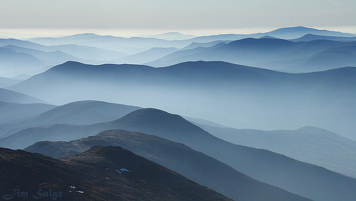
Topography and Landforms
The
topography of the WMNF is characterized by rugged, mountainous terrain,
forming part of the northern Appalachian Mountains. Elevations range
from around 400 feet in the lower valleys to over 6,000 feet at the
highest summits, with many peaks exceeding 4,000 feet. Key mountain
ranges within the forest include the Presidential Range (home to Mount
Washington at 6,288 feet, the highest peak in the Northeast), Franconia
Range, Twin Range, Bond Range, Sandwich Range, Willey Range,
Carter-Moriah Range, Pilot Range, and peaks like Mount Cabot. Other
prominent features include Cannon Mountain, Kinsman Mountain, and parts
of Mount Moosilauke (though much of Moosilauke is privately owned). The
landscape is marked by deep valleys, steep slopes, and glacial-carved
features such as U-shaped valleys, cirques, and notches (e.g., Franconia
Notch). These elements create a challenging and varied terrain, with the
highest peaks in New England offering some of the most rugged hiking and
outdoor recreation opportunities in the region. The forest's
discontinuous layout is intersected by scenic highways like U.S. Route
3, U.S. Route 302, New Hampshire Route 16, New Hampshire Route 112
(Kancamagus Highway), and New Hampshire Route 118 (Sawyer Highway),
which provide access while highlighting the dramatic elevation changes.
Geology
Geologically, the WMNF is dominated by ancient granite
bedrock, formed during the Devonian period and shaped by multiple
glaciations during the Pleistocene epoch. The White Mountains are
remnants of a much larger ancient mountain chain, eroded over millions
of years but uplifted and sculpted by ice ages. Glacial activity left
behind moraines, erratic boulders, and polished rock surfaces,
contributing to the forest's dramatic cliffs, talus slopes, and exposed
summits. Soil varies by elevation: fertile and well-drained in lower
areas, becoming thinner, more acidic, and nutrient-poor at higher
altitudes due to increased moisture leaching nutrients downslope. This
geological diversity supports unique features like the alpine zones on
the highest peaks, where freeze-thaw cycles and wind erosion create
barren, rocky landscapes reminiscent of Arctic tundra.
Hydrology
The WMNF is a critical watershed area, divided into river districts
named after major waterways: the Pemigewasset River, Androscoggin River,
and Saco River. These rivers, along with numerous tributaries, originate
from high-elevation springs and snowmelt, flowing through deep valleys
and providing clear, cold streams that support aquatic ecosystems. The
forest includes hundreds of lakes and ponds, such as the Lakes of the
Clouds near Mount Washington, as well as waterfalls like Arethusa Falls
and Silver Cascade. Hydrological features are influenced by the
mountainous terrain, with rapid runoff contributing to flash floods in
valleys and sustaining wetlands and bogs in flatter areas. The region's
abundant precipitation—up to 100 inches annually in higher
elevations—ensures a network of pristine water bodies that feed into
larger systems like the Connecticut and Merrimack Rivers.
Climate
The climate in the WMNF varies significantly with elevation, creating
microclimates across the landscape. Lower elevations experience a humid
continental climate with warm summers (averaging 70-80°F) and cold
winters (10-20°F), while higher summits endure severe subarctic
conditions. Mount Washington, for instance, holds the record for the
highest surface wind speed ever recorded (231 mph in 1934) and is known
for extreme weather, including heavy snowfall (over 200 inches
annually), frequent fog, and rapid temperature changes. Overall, the
forest receives 40-60 inches of precipitation yearly, increasing with
altitude due to orographic lift, where moist air rises over the
mountains and cools. Cloud cover shrouds peaks about 60% of the year,
and the short growing season (as little as 60-90 days above treeline)
limits vegetation in alpine areas. Harsh winds, frequent storms, and
temperature extremes make the higher elevations particularly
challenging, with winter conditions persisting into late spring.
Wildlife
The diverse ecosystems support a rich array of wildlife,
including mammals such as bald eagles, raccoons, beavers, white-tailed
deer, moose, black bears, coyotes, Canadian lynx, river otters, bobcats,
gray and red foxes, fishers, minks, and porcupines. Bird species vary by
zone, as noted above, with rare or specialized inhabitants like the
peregrine falcon and Bicknell’s thrush in higher elevations. Aquatic
species thrive in the rivers and lakes, including brook trout and other
cold-water fish. The forest's protected status helps maintain habitats
for these species amid increasing climate pressures.
The Tragic Legend of Nancy Barton
One of the most poignant and
enduring ghost stories in the White Mountains centers on Nancy Barton, a
young servant whose tale of betrayal and heartbreak unfolded in the late
18th century. In 1778, Nancy, then about 16 years old, worked on Colonel
Joseph Whipple's farm in Jefferson, New Hampshire. She fell deeply in
love with a fellow farmhand named Jim Swindell (or Jim Wilson in some
variants). The pair became engaged, and Nancy entrusted Jim with her
life savings—her dowry—to secure their future. She traveled to
Portsmouth to prepare for their marriage, but during her absence,
Colonel Whipple convinced Jim to abandon the plans and join the fight
for American independence from Britain, possibly as a way to claim the
dowry for himself. Jim and the colonel absconded with the money, leaving
Nancy devastated upon her return.
Fueled by desperation and rage,
Nancy set out on foot in the dead of winter to pursue them, trekking
nearly 30 miles through the treacherous Crawford Notch in the White
Mountains. Dressed inadequately for the brutal conditions, she crossed
an icy stream (now known as Nancy Brook), soaking her skirts and
accelerating hypothermia. She collapsed and froze to death about 20
miles into her journey, her body discovered the next day by a search
party, seated on a rock by the brook's edge with her arms outstretched
as if still reaching for her lost love. Jim, wracked with guilt upon
learning of her fate, reportedly died later in a psychiatric hospital.
The haunting aspects of this legend persist to this day. Nancy's
presumed grave is a simple cairn of stones along the banks of Nancy
Brook, within the Nancy Brook Scenic Area of the national forest. Hikers
on the Nancy Pond Trail—a moderate 8-mile out-and-back route through
dense forest and cascading waterfalls—have reported eerie phenomena,
including disembodied cries of anguish, shrieks of laughter echoing
through the trees, and whispers carried on the wind. Some interpret the
laughter as Nancy's lingering joy from her happier days, while the cries
reflect her eternal sorrow and search for Jim. The site is on private
land near the Notchland Inn, but with permission, visitors can access it
for a short quarter-mile walk. Paranormal investigators and folklore
enthusiasts suggest the area is "haunted" by Nancy's restless spirit,
forever wandering the notch in pursuit of justice. This tale has
inspired books like Marianne O’Connor’s Haunted Hikes of New Hampshire
and podcasts, emphasizing the White Mountains' unforgiving nature and
the human toll of colonial-era betrayals.
The Curse of Mount
Chocorua
Mount Chocorua, a striking 3,490-foot peak in the southern
White Mountains near Albany, New Hampshire, is steeped in a Native
American legend of revenge, loss, and a supernatural curse. The story
revolves around Chief Chocorua of the Pequawket (or Pigwacket) tribe,
who lived in the early 1700s amid escalating tensions between Indigenous
peoples and European settlers following conflicts like the 1725 Battle
of Lovewell's Pond in nearby Maine. Chocorua, a prophet or chief,
resided peacefully in the Tamworth area with his young son, befriending
a local settler family named Campbell.
In the most common version of
the legend, Chocorua left his son in the Campbells' care during a trip.
The boy accidentally ingested fox poison intended for pests and died.
Overcome with grief and suspecting foul play, Chocorua sought vengeance
by slaughtering the Campbell family (or just their children, depending
on the telling). Cornelius Campbell, the patriarch, pursued Chocorua up
the mountain's rocky slopes. Cornered at the summit—a barren, windswept
outcrop offering panoramic views—Chocorua was shot and wounded. Rather
than surrender, he raised his arms to the sky and uttered a dramatic
curse before leaping (or falling) to his death: "A curse upon ye, white
men! May the Great Spirit curse ye when he speaks in the clouds, and his
words are fire! Lightning blast your crops! Wind and fire destroy your
dwellings! The Evil One breathe death on your cattle! Panthers howl and
wolves fatten on your bones!"
The curse allegedly took hold in the
decades following, with settlers in the valley below experiencing
blighted crops, diseased livestock (later attributed to
mineral-contaminated soil), destructive storms, and other misfortunes.
This persisted until the mid-19th century, when scientific explanations
emerged, but the legend endured as a cautionary tale of cultural clash
and retribution. Variations exist: some say Chocorua simply fell while
hunting, without a curse; others frame it as a broader indictment of
colonial encroachment. The story gained popularity in the 19th century
through writers like Lydia Maria Child (1829) and painter Thomas Cole,
who depicted the scene in art.
Today, hikers on trails like the
Champney Falls Trail (a strenuous 7-mile round trip with waterfalls and
steep ascents) report hearing sorrowful cries echoing from the summit,
attributed to Chocorua's lingering spirit. The peak's ominous, jagged
profile and isolation amplify its eerie reputation, making it a focal
point for "haunted hikes" in the forest. Paranormal lore suggests the
curse lingers subtly, with unexplained accidents or feelings of dread on
foggy days.
Ghost Towns and Abandoned Settlements
The White
Mountains hide several ghost towns, remnants of 19th-century logging and
farming booms that collapsed due to economic shifts, wars, and nature's
reclamation. These sites evoke a haunting sense of impermanence, with
overgrown ruins and forgotten cemeteries.
Thornton Gore:
Incorporated in 1781 near Thornton, NH, this was an unlikely farming
outpost amid the forest's hills and rocks, boasting mills, a church,
school, two cemeteries, and over 1,100 acres of cleared land. At its
peak, it supported a small community, but the Civil War led to abandoned
farms being overtaken by woods. By 1900, most land was sold to logging
companies and later the U.S. Forest Service, integrating it into the
national forest. Today, explorers on unmarked paths off Tripoli Road (a
seasonal route closing in November) encounter cellar holes, crumbling
stone walls, rusted machinery near Talford Brook, and a cemetery with
tilted, faded headstones—creating a spooky, time-frozen atmosphere. No
specific ghosts are reported, but the isolation and decay inspire
unease, especially at dusk.
Livermore: Founded in 1876 in Crawford
Notch as a logging hub named for Samuel Livermore, it once housed
160-200 people with mills, a school, and a railroad. Deforestation,
floods, fires, and mill closures in 1928 led to its abandonment by the
1950s; the 2020 census noted just two occasional residents. Now deep in
the forest, 1.5 miles along the Sawyer River Trail off Route 302,
visitors find skeletal foundations, brick ruins, and stones emerging
from underbrush. The site's desolation fuels legends of forgotten souls,
though no direct hauntings are documented—it's more about the ghostly
echo of lost prosperity.
Other Tragic and Haunted Sites
Lakes
of the Clouds Hut: Perched at over 5,000 feet on Mount Washington, this
1915 Appalachian Mountain Club shelter has a chilling tale from an early
spring inspection. A caretaker named George encountered a spectral,
distorted human face pressing through boarded windows, melting into the
room—possibly the spirit of a hiker lost to the mountain's brutal
weather. He was found hiding in terror, never to return. Hikers report
similar presences during storms.
Mount Waternomee B-18 Bomber Crash:
On January 14, 1942, a WWII bomber veered off course in a blizzard,
crashing into the 3,800-foot peak near Woodstock, NH. Five of seven crew
survived the explosion and freezing night; remnants like fuselage and a
memorial plaque remain on the unmarked, challenging site. No ghosts, but
the tragedy adds to the forest's aura of peril.
Lizzie Bourne's
Death: In 1855, 23-year-old Lizzie perished from exposure just yards
from shelter on Mount Washington's summit during a gale. A marker
commemorates her spot, symbolizing the mountain's deadly whims.
Willey House Rockslide: In 1826, the Willey family and hired hands (nine
total) fled their Crawford Notch home during a storm, only to be buried
by a massive slide that spared the house. Three bodies were never found;
a stone marker remains, evoking the mountains' destructive power.
Russell-Colbath House: On the Kancamagus Highway, this 1832 home
features the story of Ruth Colbath, who lit a lantern nightly for 39
years awaiting her vanished husband Thomas. Nighttime passersby claim to
see the light flickering, suggesting Ruth's vigilant ghost.