Location: 15 miles (24 km) South- East of Saratoga Springs, NY Map
Area: 3,392 acres (13.73 km2)
Tel. (518) 664 9821
Open: 9am- 5pm daily
Closed: January 1, Thanksgiving
Official site
Saratoga National Historical Park (often called Saratoga
Battlefield) in Stillwater, New York, preserves the site of the
pivotal Battles of Saratoga in 1777 during the American
Revolutionary War. This was the first major American victory and
the first time a British army surrendered, marking a turning
point that secured French alliance and boosted Patriot morale.
The park includes the main Battlefield unit (about 9.5 square
miles) plus additional sites roughly 7–9 miles north in the
Victory/Schuylerville area: Schuyler House, Saratoga Monument,
Victory Woods, and the Surrender Site. It blends deep history,
scenic landscapes resembling 1777 terrain (fields, woods, hills,
and Hudson River views), and recreational opportunities like
hiking, biking, and picnicking.
Practical Visiting Information
Admission: Completely free
(no entrance fee).
Address (Visitor Center & Battlefield):
648 NY-32, Stillwater, NY 12170. Phone: (518) 670-2985.
Hours: The park is open year-round (grounds sunrise to sunset).
Visitor Center: daily 9 AM–5 PM (closed Thanksgiving, Christmas,
New Year's). Tour Road (vehicle access): typically
April–November, 9 AM–5/6 PM. Pedestrians/cyclists: sunrise to
sunset. Other sites have seasonal hours (e.g., monument climbing
weekends). Check the official NPS site or app for current
details and alerts.
Best Time to Visit: May–October for mild
weather, full access, and events (reenactments, ranger
programs). Fall offers beautiful foliage; summer can be
warm/humid; winters suit snowshoeing/cross-country skiing but
limit some facilities. Avoid peak summer weekends if crowds
bother you.
Getting There: About 30 minutes from Saratoga
Springs. Follow signs from I-87 or local roads. GPS works well;
cell service is generally good.
Parking: Ample at Visitor
Center; pullouts and lots at tour stops and other sites.
Handicap parking available.
Pets: Allowed on leash (with
rules—check NPS pets page).
Accessibility: Many areas are
wheelchair-friendly (tour road stops mostly paved, some
trails/trailside exhibits). Visitor Center accessible; ask
rangers for details.
Download the free NPS app for maps,
audio tours, and self-guided content. Brochures and maps are
available at the Visitor Center.
What to See and Do:
Start at the Visitor Center
Begin here for orientation
(highly recommended, 45–60+ minutes). Features include:
A
20-minute orientation film.
15-minute fiber-optic light map
showing troop movements.
Exhibits, artifacts, timeline,
interactive displays, and a gift shop.
Scenic overlook of the
battlefield.
Ranger info, Junior Ranger programs, and
ancestor search database.
Self-Guided Driving Tour (Tour
Road)
The highlight for most visitors is the ~9.5–10-mile
one-way paved loop road with 10 interpretive stops. It takes 30
minutes to drive straight through or 1.5–2+ hours with stops
(longer if hiking or picnicking). Bikes and walking are welcome
on the road/shoulder (multi-use lane). Stops highlight key
battle events, fortifications, and views.
Key stops often
include:
Freeman's Farm Overlook (early views of
battlefields).
Neilson Farm (historic structure, Benedict
Arnold HQ).
American fortifications, Chatfield Farm, and more
(cannons, redoubts, troop positions).
Final stops near
British lines and retreat areas.
Wayside signs, audio
tours (via NPS app), and occasional rangers enhance the
experience. The landscape—open fields, woods, ravines—closely
matches 1777 conditions.
Hiking and Trails
Wilkinson
Trail: 4.25-mile loop (pedestrian-only), immersive battlefield
hike.
Other paths and the Tour Road for walking/biking.
Victory Woods: Short ~0.5-mile accessible boardwalk/trail
through the British last encampment (trenches visible). Park at
Saratoga Monument or nearby.
Winter: Cross-country
ski/snowshoe trails.
Bring sturdy shoes, water, and bug spray
in season. Trails are generally easy to moderate.
Other
Park Units (Old Saratoga)
Drive ~7–9 miles north:
Schuyler
House (General Philip Schuyler's restored estate; tours on
weekends seasonally; grounds open daily).
Saratoga Monument:
155-foot granite obelisk with views from the top (188 steps;
open weekends seasonally). Ranger talks available.
Victory
Woods (as above).
Surrender Site: Outdoor memorial with
sculpture and Hudson River views (accessible path).
Special Events and Programs
Ranger-led tours, living history
reenactments (muskets, cannons, camps), lectures, and concerts.
Check the NPS calendar. Popular in summer/fall.
Visiting
Tips for a Great Experience
Time Needed: 2–4+ hours for
Battlefield + Visitor Center; add 1–2 hours for other sites.
Half-day minimum; full day ideal.
Weather Prep: Dress in
layers; summers warm/humid, thunderstorms possible. Sunscreen,
hat, rain gear. Winters cold/snowy—proper boots/clothing.
Food/Water: Picnic areas (e.g., behind Visitor Center). No food
services in park—bring snacks/meals or eat in nearby Saratoga
Springs/Schuylerville.
Crowds: Busier weekends/summer; arrive
early. Weekdays quieter.
Photography: Stunning landscapes,
especially at overlooks and in fall. Respect historic sites.
Families/Kids: Junior Ranger booklets, interactive exhibits,
open spaces. Educational and fun.
Combine with Nearby:
Saratoga Springs (racing, spas), other historic sites, or Hudson
River spots.
Safety: Stay on trails/roads; watch for traffic
on Tour Road. Ticks/mosquitoes in season—use repellent. No
drones or metal detecting without permits.
For Your Website:
Emphasize its "most crucial battle" status, blend of
history/nature, free access, and SEO with terms like
Revolutionary War sites, Saratoga Battlefield tour. Include
practicals (hours, directions) and vivid descriptions for
readers.
Background and the Saratoga Campaign
In 1777, British strategy
aimed to divide the rebellious Thirteen Colonies by isolating New
England from the middle and southern colonies. Lieutenant General John
Burgoyne ("Gentleman Johnny") proposed a three-pronged invasion
converging on Albany, New York. Burgoyne would lead the main force south
from Canada via Lake Champlain and the Hudson River Valley. A western
force under Barry St. Leger would advance from Lake Ontario along the
Mohawk River, and a southern force under Sir William Howe would move
north from New York City.
Burgoyne’s army—initially around
7,000–8,000 British, German (Hessian) auxiliaries, Loyalists, and Native
American allies—began well. It captured Fort Ticonderoga in early July
1777 with minimal resistance. However, progress slowed due to logistical
challenges, dense terrain, American scorched-earth tactics (felling
trees, destroying bridges, and flooding roads), and supply shortages. A
foraging detachment suffered a major defeat at the Battle of Bennington
(August 16), losing nearly 1,000 men and vital supplies. St. Leger’s
western column failed after the Siege of Fort Stanwix and the Battle of
Oriskany, and Howe sailed south to capture Philadelphia instead of
linking up.
By mid-September, Burgoyne crossed the Hudson River near
Saratoga (modern Schuylerville) with a depleted force of about
6,000–7,500 men. He faced growing American resistance.
On the
American side, Major General Philip Schuyler initially commanded the
Northern Department but faced criticism after Ticonderoga’s fall.
Congress replaced him with Major General Horatio Gates on August 19.
Gates benefited from swelling ranks of Continental troops and militia
(reaching 9,000–13,000+ by early October), inspired by successes like
Bennington and outrage over incidents like the killing of Jane McCrea.
Key subordinates included Benedict Arnold (aggressive field commander),
Colonel Daniel Morgan and his riflemen, and others like Benjamin Lincoln
and Enoch Poor.
The Battles
The Americans fortified strong
positions on Bemis Heights, bluffs overlooking the Hudson River and the
main road south, with artillery commanding key approaches. They built
field fortifications, including an "L"-shaped line.
First Battle:
Freeman’s Farm (September 19, 1777)
Burgoyne divided his army into
three columns to probe and flank American positions. Fighting centered
on Freeman’s Farm (an abandoned Loyalist farm). Morgan’s riflemen and
light infantry played a crucial role, inflicting heavy casualties on
British officers. The battle was chaotic, with the field changing hands
multiple times. The British, reinforced by Hessians, held the field
tactically but at great cost (~600 casualties vs. American ~300–400).
Burgoyne dug in, hoping for reinforcements from Henry Clinton (which
never arrived in time).
Tensions arose between Gates and Arnold over
tactics and credit. Gates later relieved Arnold of command.
Second Battle: Bemis Heights (October 7, 1777)
With supplies
dwindling and no relief, Burgoyne launched a reconnaissance-in-force.
Americans, forewarned, countered aggressively. Benedict Arnold, though
formally sidelined, rode out dramatically to rally troops (famously
leading charges, including against Breymann’s Redoubt, where he was
wounded in the leg). The British were driven back, losing key redoubts
and suffering another ~400–700 casualties. American losses were lighter.
Burgoyne retreated north a short distance but found himself surrounded
by a now-larger American force (up to 15,000–20,000). After a brief
siege and failed escape attempt, he surrendered on October 17, 1777,
under the Convention of Saratoga. About 5,800–6,000 British and German
troops became prisoners (the “Convention Army”).
Significance and
Aftermath
Saratoga was the first major American victory and the first
surrender of an entire British army. It convinced France (already
providing covert aid) to formally ally with the U.S. via the 1778 Treaty
of Alliance, bringing troops, navy, and crucial support that helped lead
to Yorktown in 1781. Spain and the Netherlands also joined against
Britain. Historian Edmund Morgan called it “a great turning point of the
war.”
Burgoyne faced criticism in Britain and never held major
command again. Gates gained fame (and briefly plotted in the Conway
Cabal against Washington) but later faltered. Arnold’s heroism
contrasted with his later treason.
The site saw limited immediate
commemoration but gained attention in the 19th century with monuments.
Establishment and Development of the Park
Efforts to preserve the
battlefield intensified in the late 19th/early 20th centuries. In 1927,
it became a New York State historic site under Superintendent George
Slingerland, who expanded it with amenities. The Great Depression
strained resources.
In 1938, Congress authorized Saratoga National
Historical Park (Public Law 576, signed June 1, 1938), one of the early
units focused on Revolutionary War history. The National Park Service
assumed full management in 1941. The Civilian Conservation Corps (CCC)
developed roads, trails, and infrastructure during the Depression.
The park today encompasses ~3,400 acres across units:
Saratoga
Battlefield (main area in Stillwater): Visitor center with film,
exhibits, 10-mile Tour Road, Wilkinson Trail, restored Neilson House
(American headquarters), and key battle sites like Freeman’s Farm and
Bemis Heights.
Old Saratoga Unit (north): Saratoga Monument (155-foot
obelisk, 1883, with statues of Gates, Schuyler, and Morgan; empty niche
for Arnold), Schuyler House (General Philip Schuyler’s estate), Victory
Woods (British last stand), and Surrender Site.
It was listed on
the National Register of Historic Places. The park preserves the
cultural landscape, conducts archaeology (e.g., artifacts and remains
found in the 1970s), and offers interpretation through living history,
tours, and programs.
Physiographic and Geological Setting
The park lies in the northern
Valley and Ridge physiographic province of New York, characterized by
Paleozoic-age sedimentary and metamorphic rocks. It sits along the
Taconic orogenic front, where ancient mountain-building processes
influenced the bedrock.
Bedrock: Primarily Ordovician-age units
(around 450–500 million years old). A major portion features the Mohawk
River Zone mélange—a jumbled mix of shale (mudstone) and greywacke (a
type of sandstone). The eastern sections include the Stillwater Shale
Zone (shale-rich flysch with greywacke), and small northwestern areas
have Rocky Tucks Zone greywacke-rich flysch. These rocks were deposited
in deep marine settings and later deformed.
Hudson River Influence:
The meandering Hudson River has incised the bedrock, creating a broad,
flat floodplain with steep cutbanks and bluffs. This provides commanding
views and defensive advantages, as seen in the battles.
Surficial
Geology: Pleistocene glacial deposits dominate the surface, including
glacial till (unsorted debris), lacustrine (lake) clay-silt and sand
from post-glacial lakes, and Holocene fluvial terraces and alluvium
along the river. These have been dissected into the modern landscape of
hills, ravines, and bluffs.
Topography and Elevation: The terrain
is rolling hills with low ridges, bluffs, and gentle slopes,
interspersed with open fields and wooded areas. Average elevation is
about 87 m (285 ft), with a minimum around 21 m (69 ft) near the river
floodplain and maximum up to 189 m (620 ft). Key features include Bemis
Heights (bluffs/ridge overlooking the Hudson), which offered the
Americans elevated defensive positions with artillery range over the
river road and floodplain.
The battlefield features small rises,
gullies, ravines, and stands of trees that limited visibility and
complicated troop movements—critical for the fighting. Dense forests and
vegetation on the flanks (especially west) made large-scale maneuvers
difficult, funneling British forces into more vulnerable positions.
Hydrology and Water Features
The park is part of the Hudson River
watershed. Streams and Mill Brook cross the area, with ravines and
drainages influencing the terrain. The Hudson River floodplain and
adjacent wetlands (over 170 acres of freshwater wetlands in the park)
add to the landscape diversity. Glacial history left behind features
that affect drainage and soil moisture.
Soils and Vegetation
Soils derive from glacial till and lacustrine deposits, varying from
well-drained on hills to wetter in lowlands. A soil resources inventory
exists for the park.
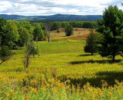
Vegetation includes mixed deciduous and
coniferous forests, open fields, hedgerows, and grasslands that create a
pastoral scene today. Historic accounts note heavily wooded terrain in
1777, which affected tactics. Modern inventories map forest types, with
ongoing management for invasives and restoration to reflect
cultural/historic landscapes.
Climate
The park has a humid
continental climate typical of the Northeast U.S., with cold winters,
warm summers, and moderate precipitation (influenced by lake-effect from
nearby water bodies, though less pronounced than farther west). Annual
precipitation supports lush vegetation but can lead to erosion on slopes
or flooding in low areas. Climate change projections for the region
include warmer temperatures, more intense precipitation events, and
shifts in snowfall to rain.
Landscape Context and Human Influence
The park sits in a scenic upper Hudson River Valley with views of
surrounding mountains and farmland. Agricultural fields, orchards, and
working farms nearby preserve viewsheds and reflect the 18th-century
setting. The 10-mile Battlefield Tour Road winds through key sites,
highlighting how geography shaped the battles: Americans used heights
and river constraints, while British forces faced challenges from dense
woods, ravines, and fortified positions.
Strategic Geography in 1777:
Bemis Heights and the narrow defile between the bluffs and Hudson
created a choke point. American defenses on the heights and floodplain,
combined with flanking wooded uplands, forced British attacks into
disadvantageous terrain. Victory Woods and northern sites show the final
British encampment and surrender area.
The park preserves a mix of
natural and cultural landscapes, with trails (hiking, biking, horse),
interpretive sites, and panoramic views from the Saratoga Monument (155
ft tall). It balances historic preservation with natural resource
management, including invasives control, forest health, and wildlife
habitat.