Location: 45 mi (72 km) West of Miami Map
Area: 2,500 sq mi (6,216 sq km)
Average rainfall: 60 in (152 cm)
Big Cypress National Preserve is a protected National Preserve located in southern Florida, directly bordering Everglades National Park to the south. Established in 1974 as the very first national preserve in the United States, it safeguards approximately 729,000 acres (about 2,951 km²) of vital freshwater swamp and wetland habitats—larger than the state of Rhode Island. This expansive area plays a critical role in sustaining the health of the broader Everglades ecosystem by channeling clean freshwater southward into the park, supporting diverse plant communities (including cypress swamps, pine flatwoods, hardwood hammocks, and prairies), and providing essential habitat for iconic wildlife such as the endangered Florida panther, black bears, alligators, wading birds, and numerous other species.
The main hub for visitors is the Oasis Visitor Center, situated along
US Route 41 (Tamiami Trail), roughly 80 miles (130 km) west of Miami and
about 50 miles east of Naples. This convenient location makes it
accessible for day trips from either city. The center operates daily
from 9:00 AM to 4:30 PM, year-round except on Christmas Day. The
adjacent Off-Road Vehicle (ORV) Permit Office is open from 9:00 AM to
3:30 PM, with vehicle inspections typically available Friday through
Monday.
Inside the Oasis Visitor Center, you'll find engaging
exhibits on the preserve's rich natural and cultural history (including
Native American heritage and early settlers), a variety of educational
materials, and an introductory film that highlights the area's unique
resources, recreational options, and conservation efforts. Knowledgeable
park staff and rangers are on hand to provide personalized advice on
activities like hiking, canoeing, wildlife viewing, scenic drives (such
as Loop Road or Turner River Road), camping, and permitted off-road
adventures.
South Florida's subtropical climate features two distinct seasons
that greatly influence your visit to Big Cypress.
The rainy (wet)
season spans from May through October, bringing hot, humid days with
frequent afternoon thunderstorms, high humidity, occasional tropical
storms or hurricanes, and abundant mosquitoes and other insects. For
those prepared with bug repellent, rain gear, and caution, this time
offers spectacular sights: dramatic lightning storms lighting up the
sky, lush green landscapes, vibrant blooming wildflowers, and
water-filled swamps teeming with life. Water levels rise, allowing
wildlife to spread out across the vast preserve.
The dry season, from
November through April, is generally the most popular time to visit.
Expect cooler, more comfortable temperatures (often in the
60s–80s°F/15–27°C), lower humidity, breezy conditions, and significantly
fewer bugs. As water levels drop, wildlife concentrates around remaining
ponds, sloughs, and canals, making it easier to spot alligators, birds
(including migratory species), deer, otters, and even the elusive
Florida panther in prime viewing areas. This season draws more visitors
for its pleasant weather and excellent opportunities for hiking,
birdwatching, and photography.
No matter the season, always check
current conditions on the official park website (nps.gov/bicy) before
your trip, as weather can vary and affect road access or activities. Big
Cypress offers a unique, less-crowded alternative to the main Everglades
National Park, with opportunities to experience the raw beauty of
Florida's wild swamp landscapes.
The main access routes through Big Cypress National Preserve are
Interstate 75 (known as Alligator Alley, a major east-west highway
across the Everglades region) and US Highway 41 (also called Tamiami
Trail, a scenic two-lane road that cuts directly through the preserve).
Most visitor services, activities, and trailheads are accessed from the
Tamiami Trail (US 41), which offers a classic drive through cypress
swamps, pine flatwoods, and open prairies teeming with wildlife.
The
Oasis Visitor Center serves as the primary hub for information, exhibits
on the preserve's ecology (including the Florida panther and other
endangered species), restrooms, and ranger assistance. It is situated
along the Tamiami Trail in Ochopee, Florida, roughly 40–50 miles west of
Miami (depending on your starting point in the city) and about 50 miles
east of Naples (or slightly less from central Naples areas).
There is
no entrance fee required to enter or explore Big Cypress National
Preserve, making it accessible for day trips, scenic drives, or extended
visits without any gate charge.
For off-road vehicle (ORV) use on the
preserve's designated trails—such as ATVs, UTVs, swamp buggies,
airboats, or street-legal 4x4s—an annual ORV permit is mandatory. This
permit must be displayed on the inspected vehicle. As of recent updates,
the fee is $100 per vehicle annually (a significant increase from the
$50 rate in 2006). Obtaining the permit involves a multi-step process:
securing a free operator permit, getting a free vehicle inspection
sticker, and then purchasing the annual vehicle permit (limited to 2,000
per year on a first-come, first-served basis, with sales starting
mid-December). These are available at the Oasis Visitor Center or other
designated NPS locations—check current details and availability directly
with the park, as rules and processes can evolve.
Once inside the
preserve, the best ways to get around depend on your preferences and
equipment:
Hiking along marked trails is a popular, low-impact option
for experiencing the diverse habitats, spotting alligators, birds, and
other wildlife up close—no special permit needed beyond standard
backcountry awareness.
Off-road vehicle travel on approved trails
(with the required ORV permit) allows deeper access into remote areas.
Scenic driving on the main highways (especially Tamiami Trail) offers
easy wildlife viewing from your car, with pull-offs and boardwalks in
some spots.
Other activities like canoeing/kayaking, bicycling on
certain paths, or ranger-led programs can enhance your exploration.
Always check the official NPS website (nps.gov/bicy) or contact the
preserve for the latest trail conditions, seasonal closures (e.g., due
to wet weather), and any updates to permits or regulations, as the area
is a dynamic wilderness.
Ranger-Led Activities
Big Cypress National Preserve offers a
variety of ranger-led programs, including guided swamp walks, boardwalk
chats, canoe/kayak tours, bike rides, astronomy sessions, and
educational talks on the area's natural and cultural history. These free
or low-cost activities provide excellent opportunities to learn about
the preserve's unique ecosystems, wildlife (like alligators and birds),
and Seminole heritage. Advance reservations are required for many
programs, especially those with limited spots or equipment. Reservations
can typically be made up to 14 days in advance. Contact the Oasis
Visitor Center (located along Tamiami Trail/US-41 in Ochopee, FL) for
the latest schedule, availability, and details—phone: +1 239-695-1201
(note: phone systems may occasionally be down; alternatives include the
Nathaniel P. Reed Visitor Center at 239-695-1168). You can also request
reservations via email through the official NPS website (nps.gov/bicy).
Programs are often seasonal, running more frequently in winter/dry
season, and may have age or height restrictions (e.g., some hikes
require children to be at least 48 inches tall).
Hunting
Hunting has a long history in this region and played a key role in early
conservation efforts to protect this remote, wild part of Florida.
Regulated hunting continues today as a traditional recreational
activity, managed cooperatively by the National Park Service and the
Florida Fish and Wildlife Conservation Commission (FWC). Seasons include
archery, muzzleloading, and general gun periods, with game typically
including white-tailed deer, wild turkey, and feral hogs. Alligator
hunting is strictly prohibited within the preserve to protect this
iconic species. Hunters must comply with current FWC regulations,
including licenses, permits, seasons, bag limits, and area-specific
rules (detailed in the Big Cypress Wildlife Management Area brochure on
myfwc.com). Always check the latest guidelines, as they change annually.
Off-Road Vehicles (ORVs)
Operation of off-road vehicles (such as
swamp buggies, ATVs, or airboats) on designated trails requires an
annual permit from the National Park Service. The fee is typically $100
per vehicle, and the permit must be displayed. This helps manage
environmental impact in the sensitive wetlands and prairies. Details on
permitted trails, vehicle inspections, and rules are available on the
NPS website or at visitor centers.
Hiking Trails
Hiking is
permitted throughout much of the preserve, including unmarked
backcountry areas and designated trails. An agreement with the Seminole
Tribe allows access across certain portions, but hikers must complete
and submit the proper paperwork (a "hold harmless" release form) in
advance. The form is available from the Florida Trail Association
(floridatrail.org) or related resources; it often requires notarization
for Florida residents and should be sent to the Tribe well ahead (at
least two weeks, with monthly hiker limits). Keep a copy with you while
hiking.
A major highlight is the Florida National Scenic Trail
(Florida Trail), which spans about 1,400–1,500 miles across the state
from the Gulf Islands to its southern terminus at the Oasis Visitor
Center in Big Cypress. Within the preserve, the trail offers some of
Florida's most remote and challenging wilderness hiking, passing through
diverse habitats like dwarf cypress domes, vast prairies, pine
flatwoods, hardwood hammocks, and seasonal wetlands. It can be divided
into logical sections:
Loop Road to Highway 41 — Approximately
8.3 miles (13.4 km) one way. This segment starts (or ends) about 13
miles from the eastern end of Loop Road Scenic Drive and finishes across
US-41 from the Oasis Visitor Center. It's well-marked with orange
blazes, winds through dwarf cypress stands and open prairies, and
crosses Robert's Lake Strand. Difficulty is easy to moderate in the dry
winter season, making it ideal for a short day hike to experience the
"middle of nowhere" solitude—often the only sounds are wind or distant
jets. However, during the rainy season (summer), expect knee- to
waist-deep water. Detailed maps and directions are on the Florida Trail
Association website or available by calling the visitor center.
Highway 41 to Interstate 75 — Approximately 28 miles (45 km) one way
(often described as part of a longer ~30-mile stretch). Trailheads are
near the Big Cypress Visitor Center on US-41 and at the I-75 (Alligator
Alley) rest area around mile marker 63. This demanding section traverses
varied terrain, including hardwood hammocks, pinelands, prairies, and
cypress domes. High ground for primitive camping exists (e.g., at
13-mile camp), but during the dry season, no reliable water sources are
available—carry all your water! It's not heavily trafficked or marked,
with vegetation overgrowth in wet months and little foot traffic. This
is strenuous and best suited for experienced backpackers, not casual
hikers.
Interstate 75 to Preserve North Boundary — Approximately 8
miles (13 km) one way (part of a ~11.9-mile northern segment). This
follows Nobles Grade, an old oil exploration road, through hardwood
areas, prairies, and pinelands. It's more elevated and shaded than
southern parts, with several backcountry campsites. North of the
preserve boundary, the trail enters the Seminole Reservation, where
access is limited to a small number of Florida Trail Association members
per month (additional permits required).
Camping in Big Cypress National Preserve offers a range of options,
from primitive backcountry-style sites to more developed areas with
basic amenities. Campgrounds can close seasonally, temporarily for
maintenance, repairs, or environmental/resource protection reasons (such
as during wildfires or wet conditions). For the most up-to-date
availability, closures, or reservations—many now require advance booking
via Recreation.gov—contact the Oasis Visitor Center at +1-239-695-1201
or check the official NPS website.
All designated campgrounds operate
on a first-come, first-served basis in some cases, but reservations are
often required or highly recommended, especially during peak winter
months (December–April) when sites fill quickly. Camping stays are
generally limited to 10 days (with some variations by season or
location, up to 14 days in off-peak periods and a yearly max of 180
days).
Here are details on the main campgrounds:
Bear Island
Campground — Open year-round (some sites/areas may have restrictions).
This is a primitive camping area with no water, restrooms, or other
facilities. It features three designated primitive sections: Bear Island
(40 sites), Pink Jeep (9 sites), and Gator Pit (9 sites). Access to the
Bear Island area is via a secondary gravel road, while Pink Jeep and
Gator Pit require an Off-Road Vehicle (ORV) Permit for access. Ideal for
those seeking a remote, rugged experience.
Burns Lake Campground —
Typically open from September 1 to January 6 (or similar seasonal
windows; check for current status as dates can vary). Primitive camping
only, with no water or restroom facilities available. Offers 40
designated sites. Great for quiet, self-sufficient campers during the
cooler months.
Monument Lake Campground — Generally open from
September 1 to April 15. This more developed option includes restrooms,
drinking water, an outdoor cold-water shower, and designated sites: 26
for RVs and 10 for tents. No electrical, water, or sewer hookups are
provided. Fees are typically around $16–$28 per night (depending on
updates; discounted for holders of Senior/Access Passes, formerly known
as Golden Age/Access). Campers here can use the dump station at Dona
Drive or Midway Campground for free while staying in the preserve.
Midway Campground — Open year-round. One of the more convenient and
developed sites, featuring a dump station, restrooms, drinking water, a
day-use area, and designated sites: 26 RV spots (with electric hookups)
and 10 tent sites. Fees are higher for RV electric sites (around
$19–$28/night) and lower for tents (around $16–$24/night), with
discounts for Senior/Access Pass holders (often halved). The dump
station is free for registered campers.
Pinecrest Campground — Open
year-round. Primitive camping with no water or restroom facilities.
Limited to 10 sites. Access is along a secondary gravel road, providing
a secluded feel away from main roads.
Mitchell's Landing Campground —
Open year-round. Primitive setup with no water or restrooms. Offers 15
designated sites. Reached via a secondary gravel road, it's suited for
those wanting solitude and self-reliance.
Additional notes:
Primitive sites emphasize "pack it in, pack it out" principles—bring all
your water, supplies, and waste removal needs. Some areas may require
ORV permits for access. Always practice Leave No Trace, watch for
wildlife (including alligators and Florida panthers), and be prepared
for bugs, humidity, and changing weather in this vast swamp ecosystem.
For the latest fees, reservations, or any fire-related closures (as seen
in recent years), refer to Recreation.gov or the NPS Big Cypress page.
Big Cypress National Preserve, spanning roughly 729,000 acres (larger
than Rhode Island) in Collier, Miami-Dade, and Monroe counties in
southern Florida, protects a vital freshwater swamp ecosystem that forms
a critical part of the Greater Everglades watershed. It supplies much of
the sheet-flow water sustaining Everglades National Park to the south
and east, while supporting unique habitats like dwarf cypress domes and
strands, hardwood hammocks, pinelands, prairies, and coastal estuaries.
Unlike traditional national parks, which strictly limit consumptive
uses, Big Cypress was established as the nation’s first national
preserve (alongside Big Thicket National Preserve in Texas) on October
11, 1974, via Public Law 93-440. This innovative category—born from
compromise—protects natural, scenic, hydrologic, and ecological values
while explicitly allowing regulated traditional activities such as
hunting, fishing, trapping, off-road vehicle (ORV) use, oil and gas
extraction, cattle grazing (historically), private inholdings, and
Native American traditional uses.
Its history spans 15,000+ years of
human presence intertwined with dramatic environmental and political
struggles, from prehistoric societies to 20th-century development
threats that nearly destroyed
Geological Origins and Prehistoric
Settlement
The Big Cypress Swamp gradually emerged from the sea
around 5,000–6,000 years ago as part of south Florida’s evolving wetland
mosaic, fed by rainfall and sheet flow from the Kissimmee River and Lake
Okeechobee southward. Humans have used the area for at least 15,000
years, with stable coastal and riverine societies developing by
6,000–3,000 years ago.
Around 2500 BCE, the Glades People (early
Archaic cultures) moved into south Florida. By 2,000–1,500 years ago,
complex societies with populations estimated at ~20,000 at European
contact thrived through fishing, hunting, gathering, and canoe travel.
Archaeological evidence includes shell mounds (discarded shell tools and
refuse piles) and shell works (large-scale ridges, platforms, and
courtyards possibly for ceremonial or flood protection purposes). One
notable site is Platt Island, with settlement evidence over 2,000 years
old.
Native American Cultures: Calusa, Seminole, and Miccosukee
The dominant pre-contact group was the Calusa, a non-agricultural
chiefdom centered on the southwest coast. Spanish accounts describe a
hierarchical society with villages, intricate ceremonial art, and a
massive shell-mound manor housing up to 2,000 people. They relied on
fishing, foraging, and shell-based tools and architecture. European
contact began with Juan Ponce de León in 1513. Diseases and conflict
decimated the Calusa and neighboring groups (Tequesta, Jeaga, Ais) by
the late 1700s; survivors retreated into the Everglades or migrated to
Cuba by 1763.
Post-American Revolution, Muscogee (Creek) peoples
migrated south, blending with remaining indigenous groups to form the
Seminole and later Miccosukee. Spain ceded Florida to the U.S. in 1819;
Florida became a state in 1845. The Seminole Wars (First: 1817–1818;
Second: 1835–1842; Third: 1855–1858) saw fierce resistance, with leaders
like Abiaka (Sam Jones) using the swamp’s mosquito-ridden wilderness as
refuge. The wars ended with a 1856 treaty ceding over 2 million acres,
but many Seminole remained, continuing cattle ranching and farming.
Reservations followed in the early 20th century (Big Cypress Reservation
opened ~1920).
Today, the federally recognized Seminole Tribe of
Florida and Miccosukee Tribe of Indians of Florida maintain permanent
rights to occupy, use resources traditionally (e.g., for chickees,
medicine, ceremonies), and develop businesses like guided tours. The
preserve’s enabling legislation explicitly protects these uses, and
tribes participate in management.
European-American Settlement,
Logging, and Early 20th-Century Exploitation
Early 19th–20th century
settlers viewed the swamp as a resource frontier. Plume hunters
decimated herons and egrets for fashionable hats; alligator and
crocodile poaching nearly caused extinction. Drainage projects from the
1880s onward (accelerating in the 1920s–1930s) aimed to convert wetlands
to farmland, disrupting hydrology.
The Tamiami Trail (U.S. 41) broke
ground in 1918 and opened in 1928, piercing the swamp and acting as a
dam that altered water flow. It opened access for settlers, tourists,
and industry. Pinecrest (along Loop Road) was platted in 1921 with grand
“next Miami” ambitions that never materialized.
Logging peaked in the
1920s–1960s, targeting old-growth cypress (prized for rot-resistant wood
used in boats, bridges, railroad ties, and military applications).
Sawmills and railroads proliferated; by the 1940s–1950s, heavy cutting
reduced majestic cypress to the dwarf forests seen today. African
American loggers formed the backbone of this workforce, many migrating
from Alabama, Georgia, and north Florida. They endured 15-hour days in
waist-deep water, slippery marl, falling trees, alligators, and
snakes—conditions described as “the toughest logging job in America.”
Company towns like Copeland were racially segregated, with Black workers
in shacks; families raised children there, and communities worshiped
together. Women like Frances Hodge cooked for crews while working. Their
labor fundamentally shaped southwest Florida’s development, though it
faded from public memory within decades.
Gladesmen (traditional
Anglo-American settlers and hunters, often called “crackers”) adapted
intimately to the ecosystem. They built narrow “glade skiffs” (2 feet
wide, 16–18 feet long, poled through shallows) and later swamp buggies
for weeks-long hunting/fishing trips. They harvested deer, hogs, turkey,
alligators, frogs, and more for market, guided researchers, and
developed profound ecological knowledge—reading subtle signs like mud
depressions or bird calls. Anthropologist Laura Ogden noted their deep
interdependence with the landscape. The 1928 Trail gave them easier
entry points.
Oil exploration began in the 1920s; Florida’s first
commercial well (Sunniland field) was discovered in 1943 by Humble Oil
(later Exxon). Fields at Bear Island and Raccoon Point expanded in the
1950s–1960s, with roads and canals further altering hydrology.
Real-estate booms in the 1950s–1960s carved subdivisions; cattle grazing
covered thousands of acres.
Everglades National Park was established
in 1947 (advocated by Ernest F. Coe and Marjory Stoneman Douglas), but
Big Cypress was excluded due to unresolved private ownership and
development interests.
The 1960s Jetport Crisis and Path to
Preservation
The pivotal threat came in 1968 when Dade County began
constructing the “world’s largest jetport” in the heart of the
swamp—plans for six runways, cargo facilities, and supporting
infrastructure (roads, rail, I-75 extensions) that would urbanize the
area and destroy the watershed. One 10,500-foot runway was completed by
1970 for training.
Environmentalists, scientists, hunters, sportsmen,
Seminoles, Miccosukees, and officials united in opposition. The 1969
Leopold-Marshall Report (and later USGS/NAS/DOI environmental impact
statements) warned of irreversible damage to hydrology, wildlife
(including the Florida panther), and water quality for the Everglades
and estuaries. Key advocates included Marjory Stoneman Douglas (Friends
of the Everglades), Nathaniel Reed, Julie Nixon Eisenhower, Governor
Claude Kirk, and others. Over 24,000 letters flooded officials;
President Richard Nixon intervened in 1970, halting full construction.
The completed runway remains today as the Dade-Collier Training and
Transition Airport (and, controversially, site of the 2025 “Alligator
Alcatraz” detention facility).
This crisis directly spurred the
preserve’s creation. In 1971, Nixon proposed federal acquisition.
Florida’s 1973 Big Cypress Conservation Act added state protections.
Congressional bills (led by Senators Henry Jackson and Lawton Chiles,
Rep. James Haley) emphasized watershed protection while accommodating
multiple uses. After hearings balancing environmentalists, tribes
(Buffalo Tiger advocated for rights), landowners, and industry, the bill
passed. President Gerald Ford signed Public Law 93-440 on October 11,
1974, authorizing ~$116–150 million for acquisition of an initial
577,000 acres.
Land Acquisition, Expansion, and Management
Evolution
Acquisition was one of the NPS’s largest and most complex
efforts: over 36,000 tracts, many small absentee-owned lots. It involved
willing-seller purchases, donations (e.g., large Collier family
holdings, which retained mineral rights), life estates, and some
condemnations. A Naples office coordinated appraisals, titles, and
negotiations; legal challenges and court backlogs delayed full
completion into the early 1980s. Inholdings (hundreds of camps and
residences) remain.
The Big Cypress National Preserve Addition Act
(1988) added ~146,000 acres (Northeast, Western, and Florida Bay units),
often via land swaps (e.g., Collier exchanges), bringing the total to
~729,000 acres and integrating with I-75.
Management has focused on
balancing protection with uses. General Management Plans (1991 for
original, 2011 for Addition), a Comprehensive ORV Management Plan
(2000), and one of the NPS’s largest prescribed-fire programs (~60,000
acres/year) address hydrology, invasive species (e.g., melaleuca),
endangered species, and recreation. Oil/gas continues under strict
regulation; hunting (deer, hogs, turkey) and frogging require licenses.
Tribal rights and private uses persist. Controversies over ORV impacts
and development have led to lawsuits and refined permitting.
Legacy and Modern Era
Big Cypress celebrates its 40th anniversary in
2014 and was designated the first national preserve Dark Sky Park in
2016. Over one million visitors annually experience its biodiversity,
scenic drives, hiking, canoeing, and cultural stories. The preserve’s
creation not only saved the watershed but established a model for
multi-use conservation that protects ecological integrity “in
perpetuity” while honoring human history—from Calusa shell works and
Seminole resilience to Gladesmen skiffs, African American logging
communities, and 20th-century activism.
Location and Size
The preserve lies on the Atlantic Coastal Plain
in Collier, Monroe, and Miami-Dade counties, roughly 45 miles (72 km)
west of Miami at coordinates 25°51′32″N 81°02′02″W. It covers 720,566
acres (2,916 km²), making it one of the largest units in the National
Park System. Its southern boundary adjoins the freshwater marl prairies
of Everglades National Park, while protected cypress lands border it to
the west. Water from the preserve flows southward and westward into the
coastal Ten Thousand Islands region of Everglades National Park.
Topography and Geology
Big Cypress sits in the northeastern South
Florida Basin, a massive subsiding feature where carbonate, evaporite,
and clastic sediments have accumulated continuously since the Late
Jurassic. The sedimentary pile beneath the preserve reaches
15,000–17,000 feet (4,572–5,182 m) thick atop Jurassic volcanic rocks.
The landscape is one of North America’s lowest, youngest, and most
stable platforms, yet it has undergone repeated submergence and
emergence due to Pleistocene sea-level fluctuations.
Surface
topography is exceptionally subtle: most of the preserve lies only a few
feet above sea level, with elevation differences of less than 3 feet (1
m) separating hardwood hammocks from surrounding marshes and prairies.
The terrain is classic karst—formed by dissolution of carbonate bedrock
(primarily limestone and dolomite) by acidic rainwater and organic
acids. This produces solution holes, sinkholes, disappearing streams,
springs, and an extensive aquifer system. A striking example is Deep
Lake, a 300-foot-diameter, 90-foot-deep water-filled sinkhole likely
formed during the last interglacial period (~130,000 years ago) and
possibly linked to a larger cave system.
Key surface rock units
include the Tamiami Formation (Upper Pliocene lightly cemented
fossiliferous sandy limestone), Miami Limestone (upper Pleistocene), and
Holocene deposits. Older units (Cretaceous Sunniland Formation and
others) lie deeper and host oil and gas. Cypress domes and strands align
with solution-collapse features in the near-surface limestone caprock,
allowing deeper rooting and nutrient accumulation.
Hydrology and
Water Systems
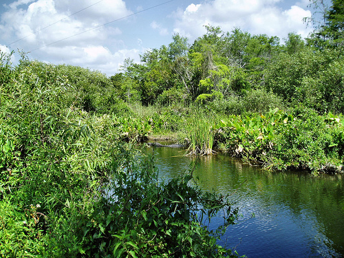
Big Cypress functions as a slow-moving freshwater
sheetflow wetland rather than a river-dominated system. Water moves
south and southwest in a broad, shallow sheet without well-defined
channels, feeding sloughs (shallow lake-like depressions), strands
(elongated cypress-lined depressions that act as flow paths), and
cypress domes. During the wet season, water spreads across prairies and
swamps; in the dry season, it concentrates in deeper strands and domes,
buffering droughts.
The preserve recharges three major aquifers: the
Biscayne Aquifer (Holocene–Pleistocene with large solution cavities),
the Gray Limestone Aquifer (Lower Tamiami), and the Sandstone Aquifer.
These carbonate-rich systems store vast amounts of water and exchange
surface and groundwater, controlling nutrient cycling. Human
modifications since the late 1800s—canals, levees, and drainage for
agriculture and development—have altered natural flow direction,
velocity, and volume, though the preserve still preserves much of the
original sheetflow pattern.
Climate
The preserve has a
tropical monsoon climate (Köppen Am), bordering tropical savanna (Aw).
Summers are hot and wet; winters are mild and drier. Average highs range
from 78 °F (25.6 °C) in January to 93.6 °F (34.2 °C) in August, with 154
days per year exceeding 90 °F (32 °C). Annual precipitation averages
60.37 inches (1,533 mm), peaking in June–September (often 9–10 inches
per month) and lowest in February (~1.56 inches). The wet season drives
sheetflow and aquifer recharge; the dry season concentrates water in
depressions and promotes karst dissolution. Hardiness zone 10b; record
high 103 °F (39 °C), record low daily high 48 °F (9 °C).
Vegetation and Ecosystems
Geology and hydrology shape a rich mosaic
of plant communities. Wet cypress forest dominates, with one-third of
the swamp covered in dwarf pond cypress and scattered stands of giant
bald cypress (some 600–700 years old). Cypress domes appear as circular
“islands” of taller trees in the center grading outward to shorter ones;
strands form linear bands along flow paths. Subtle rises (a few inches)
support hardwood hammocks (closed-canopy forests) and pinelands. Open
freshwater marl prairies border Everglades National Park to the south,
while coastal areas transition to mangroves and buttonwood ridges.
Orchids, bromeliads, and other epiphytes thrive in the humid, shaded
cypress canopy.