Location: Newton, Searcy, Marion, and Baxter Counties Map
Length: 150 miles (240 km)
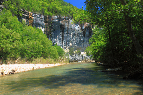
Buffalo National River, located in northern Arkansas, is a 135-mile (217 km) stretch of pristine, free-flowing waterway that winds through the Ozark Mountains, celebrated as America's first national river. Established by Congress on March 1, 1972, under Public Law 92-237, it was designated to protect one of the few remaining undammed rivers in the lower 48 states, preserving its natural, scenic, and recreational values from proposed dam construction that threatened its wild character. The river originates in the Boston Mountains of Newton County and flows eastward through rugged terrain in Newton, Searcy, Marion, and Baxter counties before joining the White River near Buffalo City, covering a total watershed of about 1,500 square miles (3,885 km²). Managed by the National Park Service (NPS) as a unit of the national park system, the 95,586-acre (38,698 ha) park encompasses diverse landscapes of towering limestone bluffs, deep valleys, waterfalls, caves, and old-growth forests, offering solitude and adventure. It attracts over 1.5 million visitors annually, generating significant economic benefits for rural communities while embodying the Ozarks' timeless beauty—often called the "gem of the Ozarks."
The plant communities that compose the forests of the Ozark Mountains
are composed mainly of Oak-Hickory communities; however, many other
types of plant communities exist and these communities are much
influenced by the geology of the area. Gradients of plant diversity and
species composition can be seen on almost any mountainside that is of
moderate elevation. Plant community composition within the Ozark
Mountains exhibit gradients of species change similar to other mountain
systems; however, these gradients are due to the accessibility of water
and nutrients and not temperature or elevations, as is the case with
other mountainous regions in the U.S.
The vegetative community at
Buffalo National River is rich and diverse. The ridges, bluffs,
hillsides, and valleys provide a variety of habitats that support over
1500 plant species. The major forest types are the Floodplain,
Mixed-Hardwood, Oak-Hickory, Oak-Pine, Cedar Glade and Beech. Forests,
cultivated fields, and abandoned fields at different stages of
ecological succession throughout the area support small herds of elk and
other wildlife.
Wildflowers can be seen nearly year round at
Buffalo National River, but spring is the peak season. Spring rains and
warm balmy days bring amazing color to the fields and roadsides of the
park. In early spring many wildflowers can be found on the forest floor.
In the eons old progression of seasons, animal abundance within the
Ozark Mountains ebbs and flows as animals migrate into and out of the
oak-hickory ecosystem that exists within the rough hills and valleys
that create the Buffalo River. With the coming of spring, animal
movement is at its highest. Fish are actively migrating up the river
corridor into tributaries, and songbirds are arriving from far off
places, filling the forest canopy with movement and song. Wildlife
observers have recorded 55 species of mammals, 250 species of birds, and
59 species of fish, along with a multitude of reptiles, amphibians,
insects and other invertebrates.
In 1995 the largest sighting of
feral hogs on the Buffalo National River was reported, a herd of 35 hogs
was observed in the Lower Buffalo Wilderness Area. Feral hogs have been
released into the park from numerous sources in the last 2 decades, and
now hogs range up and down the whole river corridor.
In 1981, the
Arkansas Game and Fish Commission began an Elk Restoration Project that
has been an overwhelming success, and now special-permit hunting is
required to keep the ever-growing population in balance. Visitors to the
park can see the elk most frequently in the late winter and early spring
in the meadows of Boxley Valley along the upper reaches of the river.
The "buffalo" in the context of the park's name is not entirely
clear. The name could refer to the American Bison, which once roamed
most of the central United States but is now no longer found in
Arkansas. On the other hand, it could also refer to a freshwater fish of
the genus Ictiobus found in the lower Mississippi river valley.
By Plane
The closest airport is Boone County Regional Airport
(HRO) in Harrison, Arkansas, which mainly handles general aviation and
limited commuter flights. For more commercial options, consider these
nearby airports, along with approximate driving times and routes to the
Tyler Bend Visitor Center (a central hub in the Middle District, about
31 miles south of Harrison on US-65):
Fort Smith Regional Airport
(FSM): Follow Interstate 40 east to Russellville, then take Arkansas
Highway 7 north to Dover, continuing via AR-27/16/377/74 north to
connect with US-65 north. Expect around 3 hours and 25 minutes.
Northwest Arkansas Regional Airport (XNA): Head east on AR-264 to
Lowell, then south on US-71 to Springdale, east on US-412 to Harrison,
and finally south on US-65. About 2 hours and 45 minutes.
Little Rock
International Airport (LIT): Take Interstate 40 west to Conway, then
north on US-65. Roughly 2 hours (though some estimates suggest up to 3
hours depending on traffic and exact destination within the park).
Springfield/Branson Regional Airport (SGF) in Missouri: Drive south on
US-65 directly. Approximately 2 hours and 15 minutes.
Important
note: GPS devices are notoriously unreliable in this rural Ozark region
and often guide drivers onto rough dirt roads or incorrect paths. Always
use a traditional Arkansas highway map or the official park map from the
NPS website for safe navigation.
By Car
Buffalo National River
stretches as a long, narrow corridor (about 135–150 miles along the
river) without a single road running parallel to it due to frequent
flooding. It's divided into three main districts and crossed by key
highways. Using Harrison, Arkansas, as a convenient starting point (a
common gateway town with services):
Upper District (areas around
Jasper and Ponca, great for hiking like Lost Valley Trail and scenic
views): Drive south from Harrison on Arkansas Highway 7 (a winding,
beautiful route) or Arkansas Highway 43.
Middle District (Tyler Bend
area, home to the main visitor center, campgrounds, and easy river
access): Head 31 miles south from Harrison on US Highway 65.
Lower
District (Buffalo Point area, with additional access points and
facilities): From Harrison, take US-65 south for about 5 miles, then
east on US Highway 62/412 to Yellville, followed by Arkansas Highway 14
south.
There is no public transportation within the park, so plan
to use your own vehicle or rentals.
Buffalo National River is free to enter—no entrance fees apply. Costs
for services like boat rentals, lodging (cabins or nearby motels), or
campsites vary depending on private providers or NPS-managed sites (some
campgrounds are first-come, first-served or reservable via
recreation.gov).
No special permit is needed to boat or paddle on the
river itself. However, anyone aged 16 or older must have a valid
Arkansas fishing license to fish (available online at the Arkansas Game
and Fish Commission site: https://www.wildlifelicense.com/ar/start.php).
Always check current regulations, as rules can change seasonally.
The Buffalo National River spans roughly 135 miles of pristine,
free-flowing waterway, making boating (by canoe, kayak, raft, or john
boat) the most scenic and practical way to explore it. The park features
22 designated river access points (put-ins and take-outs) spread along
its length, allowing flexible trips from short day floats to multi-day
adventures.
Many visitors rent boats from local outfitters, who
typically offer shuttle services to transport you and your gear to/from
access points—highly recommended if you don't have two vehicles for a
shuttle setup. Bring your own watercraft if preferred, but check river
levels and conditions first (via NPS or outfitters), as flows vary
seasonally and can affect safety and enjoyment.
Scenic Auto Tours in the Buffalo National River Area
The driving
routes described here offer only basic overviews, omitting many specific
turns, road numbers, and junctions. To navigate safely and
accurately—especially on gravel and county roads—a detailed map showing
county roads is strongly recommended to complement any provided maps or
apps.
Compton to Boxley Valley Route
Distance: About 15 miles
one way
Route overview: Starts in Compton (along Highway 43, roughly
15 miles south of Harrison) and heads to Boxley Bridge (about 2 miles
south of the Highway 43/21 intersection).
This scenic drive winds
through stunning Ozark landscapes and serves as a gateway for outdoor
enthusiasts. Compton is a key trailhead for the Ponca Wilderness Area,
where adventurous hikers can access trails leading to Hemmed-in-Hollow
Falls. This impressive 209-foot waterfall—cascading dramatically over
rugged bluffs—is renowned as the tallest between the Rocky Mountains and
the Appalachians, though it flows most reliably after heavy rainfall.
As you travel south on Highway 43, you'll pass through the quiet
community of Ponca, once a bustling hub during the peak of zinc and lead
mining in World War I. Miners in those days earned around $1.50 per day
under harsh conditions. At the intersection of Highways 43 and 74, a
lone historic cabin stands as a poignant reminder of the past. This was
the boyhood home of James "Beaver Jim" Villines (born 1854), a legendary
local trapper famous for his exceptional beaver-trapping skills. The
Villines family ranks among the earliest settlers in Boxley Valley, with
roots tracing back to the mid-19th century.
Nearby, at the Ponca
River Access point, a short, easy hike leads to the homestead where
Beaver Jim lived with his wife Sarah until the early 1930s. He passed
away in 1948 and is buried alongside Sarah in Beechwood Cemetery.
A
highlight along this route is the Lost Valley Trail, a winding path that
showcases remarkable geological wonders: a natural stone bridge, the
intriguing Cob Cave, Eden Falls, and the entrance to Eden Falls
Cave—perfect for those seeking a mix of driving and light exploration.
Boxley Valley itself is a designated historic district on the National
Register of Historic Places. Though the valley's homes, fields, and
farmlands remain privately owned, they preserve the traditional
19th-century settlement patterns, including open pastures, historic
structures, and evidence of early farming life. The area is also famous
for seasonal elk viewing, adding to its natural allure.
Erbie
Loop Route
Distance: Approximately 24 miles (mostly on gravel roads)
Route overview: Begins in Marble Falls (about 13 miles south of
Harrison; older maps may still label it as Dogpatch), proceeds to Erbie,
connects to Highway 7, and loops back to Marble Falls. A county road map
is highly recommended due to the unpaved sections.
Marble Falls was
once the site of Dogpatch USA, a now-defunct theme park inspired by Al
Capp's "Li'l Abner" comic strip series, which drew visitors from the
1960s through the 1990s. The park closed long ago, but remnants linger:
the namesake waterfall cascades beneath an abandoned train bridge (once
part of the park), and the local post office sits on what used to be the
parking lot.
The drive from Marble Falls toward the Buffalo River
meanders through lush forests and peaceful pastoral scenery. Just before
reaching the river (about half a mile prior), the Cecil Cove Loop Trail
branches off—a nearly 7-mile hiking loop that traces Cecil Creek, passes
an old homestead site, and visits a historic cemetery, offering a deeper
immersion into the area's pioneer past.
After turning left at the
Cecil Cove Trailhead intersection, you'll spot the Erbie Church on the
right, followed by the Rulus Jones Homestead. The church, school, post
office, and store once formed the heart of the small Erbie community.
Locals recall the church being constructed around 1896, and it remains
available for occasional services today. The nearby homestead, built by
Rulus Jones in 1922 as a frame house, replaced an even older log cabin
from the late 1830s—illustrating the shift from early log construction
to more modern frame buildings in the Ozarks.
After crossing the
Buffalo River, the Parker-Hickman Farmstead stands out as one of the
oldest surviving structures in the entire Buffalo National River area.
In the late 1830s, brothers Alvin and Greenberry Parker arrived from
Tennessee and constructed their home using abundant local red cedar
logs, joined with skilled half-dovetail notches—creating one of the
finest log houses in the valley. The farmstead, on the National Register
of Historic Places, represents a rare, continuously operated upland
Ozark farm that endured for over 140 years until the 1980s.
Nearby,
the Cedar Glade Picnic Area offers river overlooks and an accessible
trail to South Pond, complete with a fishing dock (across the road). A
non-accessible hiking path leads to North Pond, with a short 0.4-mile
connector between the two. The Koen Interpretive Trail (accessible)
winds through the Henry R. Koen Experimental Forest, established in
1950, highlighting over 34 species of trees and plants along its loop.
Trail guides are available at the Pruitt Ranger Station or the Forest
Service office in Jasper.
Finally, Ozark Campground occupies a
fertile valley once farmed by the Shaddox family, who grew peas and corn
here. Today, it's a favored spot for camping, swimming, and easy canoe
access to the Buffalo River, blending history with modern recreation.
The scenic route "Buffalo Point and Beyond" spans approximately 38
miles, featuring a mix of paved and some gravel roads that wind through
the stunning landscape of the Buffalo National River area in northern
Arkansas. The path starts in Caney (about 10 miles south of Yellville)
and continues through Maumee, Rush, Buffalo Point, and ends at Dillard's
Ferry.
From Caney to Maumee, the drive offers expansive views of open
pastures and rolling hills typical of the Ozarks countryside. The Maumee
area owes its name to the North Arkansas Mining Company, which developed
it in the late 1890s primarily for zinc ore mining. The company's land
surveyor, who grew up near the Maumee River in Ohio, chose the name in
honor of his hometown. Mining activity here reached its height during
World War I, when demand for zinc surged due to its use in producing
brass for ammunition. Today, Maumee serves as a popular put-in spot for
canoeists and kayakers enjoying the Buffalo River. Along the road
leading to the canoe launch (just outside the park boundary), visitors
can still spot the weathered foundations of the old crushing mill and
the sealed entrance to the Maumee Mine, remnants of this once-thriving
industrial past.
Further along, the route passes through Rush, a
historic zinc mining boomtown that sprang up in the 1880s after rich
zinc ore deposits were discovered along Rush Creek. By the 1890s, the
area was in full swing, drawing miners, investors, and workers from
across the United States. The influx was so massive that local farmers
struggled to supply enough fresh meat and eggs to meet demand. At its
peak, around World War I, about 15 mines operated in the Rush District,
making it one of Arkansas's top zinc-producing regions. The most
prominent was the Morning Star Mine, renowned for its large-scale,
quarry-like ore extraction—one notable haul included a massive
12,750-pound chunk of pure smithsonite (zinc carbonate).
Today, Rush
is a preserved ghost town within the Buffalo National River, listed on
the National Register of Historic Places for its significance in
northern Arkansas mining history. A short quarter-mile interpretive loop
trail winds through the Morning Star area, passing ruins such as the
stone smelter (built in 1886 as the oldest structure in Rush),
blacksmith shop, mill foundations, and other remnants of the mining era.
A more challenging 3-mile one-way trail climbs above the valley,
traversing steep, rocky terrain and offering views of additional mine
ruins scattered across the hillsides. (Note: Mines are extremely
unstable and dangerous—entry is strictly prohibited for safety reasons.)
Trail guides and maps are available at the Buffalo Point Ranger Station
to help visitors explore responsibly.
The route culminates at Buffalo
Point, a beautifully developed area created through collaboration
between the National Park Service, the Civilian Conservation Corps
(CCC), and the Arkansas State Parks Commission. It opened as Buffalo
River State Park in 1938 before becoming part of the Buffalo National
River in 1972. The rustic CCC-era structures—built from local stone and
rough-cut wood between the late 1930s and 1940s—are listed on the
National Register of Historic Places for their architectural and
historical value. Several well-maintained hiking trails here vary from
easy quarter-mile strolls to more moderate 3.5-mile outings, leading to
breathtaking scenic overlooks, natural caves, a picturesque waterfall,
and other natural features. During summer months, the park offers
regular interpretive programs on the area's ecology, history, and
wildlife—schedules and detailed trail guides can be picked up at the
Ranger Station.
Finally, the journey reaches Dillard's Ferry, named
after Doc Dillard, who constructed the original hand-operated ferry in
the early 1900s with help from his sons Ira and Pate, along with W.
Davenport. This ferry served as a vital river crossing for decades until
the modern bridge was completed in 1959; the old ferry site lies just a
short distance downstream from the current bridge. The Buffalo River has
a dramatic history of flooding here, most notably in December 1982, when
torrential rains (8–9 inches in under 24 hours across the watershed)
caused the river to rise an astonishing 65 feet (about 19.8 meters)
above normal levels—the highest flood on record—covering the Highway 14
bridge and devastating surrounding areas.
Backpacking: Buffalo River Trail (BRT)
The Buffalo River Trail
(BRT) is a premier backpacking route that showcases the park's wild
essence. The main upper section stretches approximately 37 miles (with
some sources noting slight variations around 36–40 miles due to minor
reroutes or measurements) from Boxley Valley in the west to Pruitt near
Highway 7 in the east. It winds through breathtaking scenic overlooks,
remnants of old homesteads and pioneer homesites, rugged wilderness
areas, and dense hardwood forests teeming with wildlife.
The most
challenging and strenuous portion lies between Boxley Valley and Erbie,
featuring steep climbs, sharp switchbacks, and significant elevation
changes that reward hikers with panoramic views of the Buffalo River far
below and dramatic canyon-like side drainages. Beyond Erbie, the terrain
becomes more moderate and forgiving, following a gentler river corridor
with easier gradients and more pleasant walking.
Unlike the historic
Old River Road Trail (which hugs the river closely and requires multiple
ford crossings), the BRT stays higher on the south side, avoids river
crossings entirely, and is designated for hikers only (no horses, bikes,
or vehicles).
Key trailheads with access points include:
South
end of Boxley Valley
Ponca Low Water Bridge (limited or no overnight
parking)
Steel Creek
Kyles Landing
Erbie
Ozark
Pruitt
Ranger Station
Most trailheads offer overnight parking except
Ponca Low Water Bridge.
The trail continues eastward in sections. A
newer segment extends from Woolum through areas near Highway 65 (Tyler
Bend vicinity) toward Gilbert and beyond, with the middle/lower portions
along the south side of the river totaling around 42–43 miles to
Dillard's Ferry near Buffalo Point. When fully connected, it may link to
other regional trails.
Detailed trail maps and guides are available
for purchase at the Eastern National Bookstore, park headquarters,
visitor contact stations, or online through NPS resources.
Backpacking: Ozark Highlands Trail (OHT)
The Ozark Highlands Trail
(OHT) is a longer, rugged route spanning about 165 miles (266 km) from
Lake Fort Smith State Park westward, extending through the Ozarks to
Richland Valley near Woolum on the Buffalo River. (Note: The full trail
continues farther east in sections, with ongoing development toward
connections in Missouri.)
If hiking sections that start or end at
Woolum, exercise caution with the Richland Creek and Woolum River
(Buffalo River) crossings. These fords can become swift, deep, and
hazardous—especially during winter and spring high-water periods due to
rain or snowmelt. Avoid them during high flows and choose alternate
routes for safety.
Maps and guides for the OHT are sold at the same
locations as the BRT: Eastern National Bookstore, park headquarters, and
visitor stations.
Day Hiking Trails
The park features many
shorter, rewarding trails perfect for day hikes, ranging from easy loops
to more strenuous options.
Lost Valley Trail (near Ponca/Lost
Valley Campground): A popular 2.1–2.4 mile round-trip (easy to moderate)
that follows Clark Creek through a scenic box canyon. Highlights include
multiple waterfalls (like Eden Falls), towering limestone cliffs, a
massive bluff shelter, a striking natural bridge (a 50-foot limestone
tunnel), Cobb Cave (about 200 feet long, ending in a large room with a
35-foot waterfall inside—bring flashlights/headlamps for safe
exploration), and vibrant spring wildflowers. The first half-mile is
wheelchair-accessible with benches.
Ozark to Pruitt Trail (at
Pruitt): A 2.6-mile out-and-back featuring abundant wildflowers blooming
from March through June, adding colorful displays along the path.
Mill Creek Trail (at Pruitt): A 2.1-mile loop starting at the east end
of the Pruitt river access. This mostly level trail meanders through a
lush lowland hardwood forest beside Mill Creek and passes a historic
pioneer homesite. Best enjoyed early in the season before tall summer
grasses overgrow sections. More details available at Pruitt Ranger
Station or park headquarters.
River Overlook Trail (at Tyler Bend): A
1.1-mile loop beginning at the Collier Homestead parking area. It visits
the well-preserved Collier Homestead (offering a glimpse into pioneer
life in the hollows, ridges, and river corridor) and provides scenic
overlooks of the Buffalo River. The first half-mile (including the
homestead and initial overlook) is wheelchair-accessible. Connects to
the Buffalo River Trail from the parking area.
Indian Rockhouse Trail
(at Buffalo Point): A 3.5-mile loop starting between the ranger station
and restaurant. It leads to a large bluff shelter (rockhouse)
historically used by Native Americans, with a strenuous uphill return
climb.
Overlook Trail (at Buffalo Point): An easy 0.6-mile hike to a
beautiful panoramic overlook of the Buffalo River, starting from the
same trailhead area.
Campground Trail (at Buffalo Point): A 1.3-mile
connector linking the campground to the ranger station, concession
cabins, and other trails in the area.
Forest Trail (at Buffalo
Point): A short 0.7-mile path from group campsites to the canoe launch
area.
Morning Star Loop Trail (at Rush): A quick 0.3-mile loop
passing ruins of the Morning Star Mine (including a blacksmith shop,
livery barn, and 1886 smelter remnants). Start at the Morning Star
Trailhead—do not enter old mine shafts for safety.
Rush Hiking Trail
(at Rush): A 2.2-mile trail beginning at either the Morning Star
Trailhead or Rush Landing, completed to Clabber Creek, offering more
historic mining context and Ozark scenery.
Boating
The Buffalo
National River in Arkansas offers one of the most scenic and pristine
floating experiences in the Midwest, and the absolute best way to fully
appreciate its stunning bluffs, clear waters, lush forests, and abundant
wildlife is by paddling a canoe, kayak, or similar vessel down the
river.
There are 22 designated river access points scattered along
its length, making it accessible for trips of varying durations—from
short day floats to multi-day adventures. You can bring your own canoe,
kayak, raft, or flat-bottomed john boat (no permit needed for
non-motorized craft), but many visitors find it more convenient to rent
from one of the local authorized concessioners. These outfitters
typically provide boats, paddles, life jackets, and shuttle services to
and from access points.
Motorized boats are allowed only with engines
of less than 10 horsepower, and any motor must be properly registered in
Arkansas. Life jackets (personal flotation devices) are mandatory on all
vessels—every person must have a properly fitted, USCG-approved one in
good condition and the right size. Children 12 and under must wear
theirs at all times while on the water. For safety, always follow U.S.
Coast Guard standards.
To help keep the river clean and safe, no
glass containers are permitted within 100 feet of the river, its
tributaries, trails, or in caves (with exceptions only in designated
campgrounds, picnic areas, or vehicles on roads). Additional rules
include using mesh litter bags for trash on vessels, securing cooler
lids to prevent spills, and using floating holders (like koozies) for
drinks not in sealed containers. Polystyrene (Styrofoam) coolers are
banned while floating or camping in most areas.
Floating the Buffalo
can be an unforgettable, peaceful experience, but safety comes first.
Always check current river conditions beforehand—levels and flows can
change quickly due to rain or season. Information is posted at access
points, available online via USGS gauges or NPS sites, or by calling a
ranger station or visitor center. Avoid high water, which can create
swift currents and hazards.
Canoe and Kayak Rental Providers
(Authorized Concessioners, as of recent listings; contact them directly
for current rates, availability, and reservations, especially for the
2026 season):
Upper River (e.g., Boxley/Ponca to Carver area):
Buffalo River Canoes — ☏ +1 870-446-2644 (www.floatthebuffalo.com)
Buffalo Outdoor Center — ☏ 1-800-221-5514
Lost Valley Canoe & Lodging
— ☏ +1 870-861-5522 (www.lostvalleycanoe.com)
Crockett's Canoe Rental
— ☏ 1-800-355-6111 (www.buffalorivercanoerental.com)
Middle River
(e.g., Carver to South Maumee):
Buffalo River Outfitters — ☏
1-800-582-2244 (www.buffaloriveroutfitters.com)
Silver Hill Float
Service / Silver Hill Canoe — ☏ +1 870-439-2372
Lower River
(e.g., North Maumee/Buffalo City area):
Dirst Canoe Rental — ☏ +1
870-449-6636 (www.dirstcanoerental.com)
Wild Bill's Outfitter — ☏
1-800-554-8657
(Additional outfitters may be available; check the
official NPS website for the full, updated list.)
Fishing
The
Buffalo National River is renowned among anglers for its diverse
fishery—one of the richest in the U.S. in terms of total fish species.
Its long, deep pools and shallow, rocky riffles create ideal habitat for
smallmouth bass (the star of the upper river), largemouth bass, spotted
(Kentucky) bass, Ozark bass, channel catfish, and various panfish like
sunfish and perch.
Popular techniques include bank fishing along
accessible shores or float fishing from flat-bottomed johnboats
(especially common on the lower, eastern sections where waters are
calmer). All fishing follows Arkansas Game and Fish Commission
regulations plus any National Park Service overlays. Anglers 16 and
older need a valid Arkansas fishing license. Catch-and-release is
strongly encouraged for smallmouth bass—use artificial lures, barbless
hooks, and handle fish minimally to maximize survival. Recent proposed
updates (pending final approval for 2026) may designate the Buffalo as a
"blue-ribbon" stream with stricter limits (e.g., one smallmouth per day
at 15 inches minimum), so check the latest AGFC rules before your trip.
Swimming
The crystal-clear waters of the Buffalo are inviting for
cooling off on hot days, with many gravel bars and deep pools perfect
for wading or swimming. However, there are no lifeguarded areas, so swim
at your own risk. Never swim alone, and avoid the water entirely during
high flows when currents can be dangerously strong and deceptive. Diving
or jumping is extremely hazardous due to submerged rocks, logs, and
uneven bottoms that are often invisible from the surface. The same glass
container prohibition applies here as on the river itself.
Bird
watching
Bird watching is one of the most rewarding activities at
Buffalo National River, where enthusiasts can observe a rich diversity
of avian life in a stunning natural setting. The park serves as a vital
biological crossroads in the Ozark region, featuring a mosaic of
habitats—including lush forests, rocky bluffs, river corridors, and open
woodlands—that support an impressive array of bird species. Over 200
species (with some sources noting up to around 232 recorded) visit the
area during various parts of the year, while nearly half remain
year-round residents. Common sightings include majestic Bald Eagles
soaring along the river, graceful Great Blue Herons and Belted
Kingfishers fishing in the waters, colorful Wood Ducks, and a variety of
songbirds, woodpeckers, and raptors thriving in the diverse ecosystems.
Bird checklists, which help visitors identify and track what they spot,
are readily available at ranger stations and visitor centers throughout
the park.
A highlight for birders is the Annual Christmas Bird Count,
held each December and organized in partnership with the National
Audubon Society. This beloved event traces its origins to a meaningful
shift in tradition: it began as a peaceful alternative to the
once-popular "side hunt" on Christmas Day, where teams competed to shoot
the most birds and other wildlife. On December 25, 1900, dedicated
groups started counting birds instead of hunting them, marking the start
of citizen science in ornithology. Today, the Christmas Bird Count
stands as the world's longest-running wildlife census, offering
invaluable long-term data on bird populations, migration patterns, and
overall environmental health.
Horseback riding
Horseback
riding provides another fantastic way to immerse yourself in the beauty
of the Buffalo National River. With over 75 miles of designated
equestrian trails spanning the park's three districts and more than
95,000 acres of protected land, riders can explore scenic routes on
horseback while respecting sensitive areas (horses and pack animals are
allowed only on these marked horse trails).
In the upper district,
popular options include the Old River Trail, Cecil Cove Loop,
Centerpoint, Chimney Rock, Sneeds Creek, and Bench Trail. The middle
district features sections of the Buffalo River Trail (particularly from
Woolum to Gilbert). In the lower district, the Cook Hollow/Cow Creek
Loop (accessed via Hathaway Gap trailhead) is a favorite among riders.
For overnight adventures, several drive-in horse camps are available
on a first-come, first-served basis:
Steel Creek (upper river) offers
14 sites.
Erbie (upper river) provides 5 sites.
Woolum (middle
district) serves as a designated horse camp.
In the Lower Buffalo
Wilderness Area, primitive camping is permitted at trailheads like Big
Creek or Hathaway Gap.
Each site typically limits groups to 6
people and 4 horses, with a maximum stay of 7 days. Note that no
commercial horse outfitters operate within the park, so visitors must
bring their own horses and gear. Always check current trail conditions
and regulations at a visitor center before heading out. Whether you're
spotting rare migrants or riding along tranquil trails, these activities
highlight the park's wild, untamed charm.
Most authorized concessioners operating within Buffalo National River offer gift shops where visitors can purchase souvenirs, park-related merchandise, snacks, basic supplies, and other items to enhance their trip.
For meals, you'll find a variety of restaurant options in nearby
towns such as Harrison, Jasper, Yellville, and other surrounding
communities, ranging from casual diners to local eateries serving
Arkansas-style comfort food.
Within the park itself, the only on-site
restaurant is operated by Buffalo Point Concession at Buffalo Point in
the Lower District. This diner serves breakfast, lunch, and dinner
during the peak season (typically Memorial Day through Labor Day), with
possible extended weekend hours in the fall. It offers a scenic overlook
of the Buffalo River, along with items like sandwiches, soups, salads,
desserts, and coffee—perfect for a relaxing meal after hiking or
floating. Many canoe rental concessioners also sell snacks, prepared
foods, or groceries for quick bites.
Alcohol policies at Buffalo National River follow National Park
Service rules and Arkansas state laws. Possession and consumption of
alcohol are allowed in the park (for those of legal drinking age, 21+),
but with important restrictions to ensure safety and protect the
environment.
No alcohol is sold anywhere within the park boundaries,
so plan to bring your own if desired—it's considered a privilege, not a
guaranteed right. You must consume it responsibly; excessive
intoxication or alcohol-related misconduct (such as endangering
yourself, others, property, or park resources) can result in eviction
from the park or other penalties.
Key restrictions include:
No
alcohol is permitted inside any government buildings (like visitor
centers).
Glass containers are strictly prohibited on or within 100
feet of any river, stream, or waterway (for safety and to prevent
litter/environmental harm). Use plastic, aluminum (in floating holders
like koozies), or other non-glass options.
Additional river rules
apply when floating: beverages must be in sealed coolers to prevent
spills, and non-secure containers need floating holders to avoid
sinking.
Lodging: Cabins at Buffalo Point
The only in-park lodging is
provided by Buffalo Point Concession (phone: +1 870-449-6206; address:
2261 Hwy 268 E, Yellville, AR). They offer:
Rustic cabins
(historic CCC-era builds from around 1939): Typically available from
early March through late November.
Modern cabins (including duplex
units) and a small lodge: Available year-round for more comfort.
A
total of about 17 cabins during peak season, with several modern options
open in winter.
These popular cabins can be reserved up to 18
months in advance (previously noted as 15 months). Extra guests beyond
the standard 2 people cost $5 per person (maximum occupancy usually
around 6 per cabin).
Current seasonal rates (subject to change):
Winter (December–February, modern cabins only): Around $58/night.
Summer/peak (March–November): Approximately $81/night for rustic,
$76/night for modern.
For bookings and details, visit
buffalopoint.lodgify.com or contact the concession directly. Other
nearby options include private cabins, bed & breakfasts, and motels in
surrounding towns.
Camping Options
The park features 13+
campgrounds, ranging from primitive (no fees, basic facilities) to
modern with amenities like showers and hookups. Most are first-come,
first-served, but some now require reservations through Recreation.gov
(recreation.gov) or by calling 877-444-6777. As of 2026 updates, several
campgrounds (e.g., Steel Creek, Ozark, Carver, Tyler Bend, Rush) require
advance reservations from mid-March through mid-November, with no
cash/check payments accepted on-site in those cases. Fees are typically
charged March–November (or similar seasonal window), with free primitive
camping in winter at many sites.
Camping is limited to 6 people per
site in most cases. Large RVs, trailers, buses, or motorhomes are not
recommended on steep/winding access roads to places like Steel Creek,
Kyles Landing, or Mt. Hersey.
Here are key campgrounds with details:
Buffalo Point (most developed, Lower District): 83 drive-in sites
(including some accessible for disabled visitors) + 20–21 walk-in sites.
Amenities include picnic tables, fire grates, year-round drinking water
(in certain loops), showers, flush toilets, water/electric hookups, and
a dump station (seasonal March–November). On-site restaurant/diner
available seasonally. Very popular—fills quickly on weekends from
Memorial Day to mid-August. Fees (per night): Drive-in ~$30 (electric
sites), walk-in ~$20; pavilion/group sites ~$50. Reservations available.
Tyler Bend (Middle District, year-round access): 28 drive-in + 10
walk-in sites, plus 5 reservable group sites (for 10–25 people,
tent-only). Some accessible sites. Year-round picnic tables, fire
grates, drinking water; showers, flush toilets, and dump station
April–October (no site hookups). Pavilion reservable. Fee: ~$20/night
(or $12 in older info—check current); pavilion ~$50.
Steel Creek
(Upper District, scenic near Ponca): 26 walk-in tent sites + 13–14
horse/equestrian sites. Basic amenities: picnic tables, fire grates,
drinking water and vault/flush toilets (March–November). No hookups.
Reservations required for many sites mid-March–mid-November. Fee:
~$20/night.
Ozark: 35 drive-in sites (some reservable), pavilion
available. Picnic tables, fire grates, drinking water, flush toilets
(seasonal). Fee: ~$20/night camping; pavilion ~$25–$50.
Carver
(semi-developed): 8 tent-only sites. Picnic tables, vault toilets,
drinking water (seasonal). Now requires reservations in season. Fee:
~$16–$20/night.
Rush (semi-developed, historic area): 12 tent-only
sites. Drinking water, fire grates, vault toilets (year-round vault).
Reservations required in season. Fee: ~$16–$20/night.
Kyles Landing:
33 sites, picnic tables, fire grates, drinking water, flush toilets
(seasonal). Fee: ~$20/night.
Erbie (modern): 14 drive-in + 16 walk-in
+ 10 group sites. Some accessible. Picnic tables, fire grates, drinking
water, flush/vault toilets. Fee: ~$20/night.
Lost Valley: 15 sites,
some accessible. Picnic tables, fire grates, drinking water, flush
toilets (April–October). Fee: ~$20/night (or $10 in older info).
Maumee South and Mt. Hersey (primitive): Open camping, vault toilets,
fire grates (Mt. Hersey); no water. Free, first-come, first-served.
Spring Creek (semi-developed): 14 sites, picnic tables, fire grates,
vault toilet. No drinking water. Free.
Many campgrounds offer
accessible sites where noted. Backcountry camping is also permitted
(free, no permit required, but follow Leave No Trace and 30-day limit
rules).
Location, Path, and Extent
The river begins as the Main Prong of
Big Buffalo Creek in the highest reaches of the Boston Mountains (part
of the Ozarks) in Newton County, roughly 15 miles above the national
river boundary. It flows generally west-to-east (initially northward
through Boxley to Ponca, then eastward) across Newton, Searcy, Marion,
and Baxter counties. It empties into the White River (a Mississippi
River tributary) along the Marion-Baxter county line near Buffalo City.
The Buffalo National River park unit covers ~94,293 acres (including the
river corridor and adjacent lands), but the full watershed drains over
846,000 acres (~1,320 square miles). Elevations drop dramatically from
2,576 feet at the headwaters in the Boston Mountains to 351 feet at the
White River confluence.
Physiographic Regions and Topography
The watershed spans three distinct Ozark physiographic subregions, each
influencing the river’s character:
Boston Mountains (upper ~34%
of watershed): Rugged, high-relief terrain (elevations 1,200–2,300+ ft)
underlain by Pennsylvanian-age sandstones, shales, and limestones.
Narrow, winding ridges separate steep-sided valleys with up to 1,000 ft
of relief. The headwaters feature a flat-to-gently rounded plateau with
high-walled drainages, sheer rock walls, and sharp ridges/cliffs. This
section has the steepest gradients and most dramatic scenery.
Springfield Plateau (middle ~47%): Gentler terrain (elevations
1,000–1,700 ft) with local relief of only 200–300 ft. Dominated by
Mississippian-age cherty limestones. The river here meanders more, with
broader valleys and alluvial bottoms.
Salem Plateau (lower ~19%):
Lowest and most subdued (gently rolling hills, 50–100 ft relief)
underlain by older Ordovician–Silurian–Devonian limestones, dolomites,
and sandstones. The river widens with larger pools.
Overall
topography features narrow ridge tops, steep slopes alternating with
vertical escarpments, and a deeply incised river channel that has cut
into bedrock over millions of years. The river alternates between
bedrock-confined sections and meandering alluvial floodplains with
gravel bars and terraces.
River Gradient and Channel
Characteristics
The Buffalo’s gradient decreases downstream, creating
varied paddling conditions:
Ponca to Pruitt: ~13 ft/mile (faster,
riffle-pool sequence).
Pruitt to Hwy 65: ~5 ft/mile.
Hwy 65 to
mouth: ~3 ft/mile (slower, wider pools).
The channel is
vertically stable—bedrock is often exposed or covered by only a thin
layer of gravel/sand. Quiet pools separated by short riffles dominate,
with seasonal flow variations (dry sections possible in late summer/fall
upstream; more reliable downstream).
Geology and Landforms
All
bedrock is sedimentary (Paleozoic age, ~300+ million years old),
deposited in ancient marine environments and later uplifted/erosionally
dissected. Key formations include:
Upper reaches: Atoka and Bloyd
Formations (shale, sandstone, minor limestone).
Mid-reaches: Pitkin,
Fayetteville, Batesville, Hale (limestone with shale/sandstone).
Dominant karst-forming unit: Boone Formation (cherty limestone, ~31.8%
of watershed surface).
Lower: St. Peter Sandstone, Everton Formation,
and older Ordovician carbonates (limestone/dolomite).
The river
has carved massive vertical bluffs (often 200+ ft high) at bends,
especially in limestone sections. Waterfalls, alcoves, and sheer cliffs
are common. A notable example is the 200-ft waterfall in
Hemmed-in-Hollow—the tallest between the Appalachians and Rockies.
Karst Topography and Hydrology
Approximately 64% of the watershed
is underlain by soluble limestone and dolomite, producing classic karst
features through chemical dissolution by acidic groundwater. Over 500
caves, 200+ rock shelters, 120+ other karst features, and 200+ springs
have been documented. Prominent examples include Fitton Cave (Arkansas’s
longest) and numerous “pour-offs” (waterfalls cascading off bluffs).
Springs and losing streams are abundant; some river sections lose flow
underground during dry periods before resurfacing.
Climate–Geography Interactions
Humid subtropical climate (hot
summers, mild winters; growing season ~200 days) drives erosion,
vegetation recovery, and karst processes. Precipitation (30–80
inches/year) and freeze-thaw cycles accelerate bluff undercutting and
cave formation. Vegetation (forests on slopes, grasses on bottoms)
stabilizes soils but also contributes organic acids that enhance
limestone dissolution.
Prehistoric and Native American Occupation (c. 12,000 BCE–1830s)
Humans have lived in the Buffalo River watershed for at least
10,000–12,000 years, beginning with Paleoindian hunters and gatherers
who exploited floodplains, ridgetops, and bluff shelters. The Ozark
Plateau's geology—uplifted sedimentary rocks (limestone, dolomite,
sandstone) eroded into bluffs, caves, and alluvial valleys—provided
ideal sites. Bluff shelters preserved perishable artifacts like
basketry, cordage, netting, fabrics, and seeds, revealing a diet of
game, fish, wild plants, and later domesticated crops.
Cultural
periods include:
Paleoindian/Dalton (c. 12,000–8,000 BCE) — Early
mobile hunters.
Archaic (c. 8,000–500 BCE) — Semi-permanent villages
and intensified plant use.
Woodland/Mississippian (c. 500 BCE–1500
CE) — Bow-and-arrow technology, trade networks, and ceremonial systems
(some linked to Caddoan influences).
No large permanent villages
existed late in prehistory, but evidence shows extensive use of
bottomlands and shelters for storage and burial. By the historic period,
the Osage hunted the western Ozarks without permanent settlements. The
Cherokee arrived after eastern displacements. Under the 1817 treaty
(signed by Andrew Jackson and others), they received lands between the
Arkansas and White rivers, including the Buffalo watershed. Some
Cherokee settled briefly (e.g., a legendary village called Sequatchie on
Spring Creek in Searcy County under Peter Cornstalk; another documented
on Bear Creek). Conflicts with Osage and dissatisfaction with the land
led to the 1828 treaty ceding Arkansas claims for Oklahoma territory;
most departed by the early 1830s.
European Exploration and Early
Settlement (Early 1800s–1860)
European contact was limited until the
19th century. Hernando de Soto's 1541 expedition may have passed nearby
(speculative), and French coureurs des bois possibly visited. The river
first appeared on maps as “Buffaloe Fork of the White” from Zebulon
Pike's 1806–1807 expedition (named for abundant bison, extinct in the
area by ~1820). Henry Rowe Schoolcraft's 1818–1819 journey described
sparse, hunting-based populations north of the Buffalo.
American
settlement accelerated after the 1828 Cherokee removal and Louisiana
Purchase (1803). Squatters and pioneers (mostly from Tennessee and
Missouri) claimed bottomlands for subsistence farms—corn, livestock,
hunting. Key early settlers included Robert Adams (Bear Creek, ~1822),
John Brisco (near Jasper, ~1825), Solomon Cecil (Cecil Creek), and
Samuel Hudson (Panther Creek, ~1832; built a gristmill and reportedly
killed hundreds of buffalo). Population grew slowly due to rocky soil,
floods, poor roads, and isolation; by 1860, the three main counties
(Marion, Searcy, Newton) had ~14,856 people. Slavery was minimal (fewer
than 400 enslaved people total; small farms averaged 28 improved acres).
Counties formed: Marion (1835/36), Searcy (1838), Newton (1842). Towns
were few; Buffalo City at the mouth was the largest. Life centered on
self-sufficiency, with mills, churches, and schools. Illiteracy remained
high (40–60%).
Civil War and Immediate Aftermath (1861–1870s)
The Ozarks' highland residents showed mixed loyalties. Arkansas seceded
in May 1861, but the northwest had few slaves and strong Unionist/Peace
Society sentiments (a secret anti-draft group with hundreds of members
in Searcy and Marion counties). Arrests, forced Confederate enlistments,
and guerrilla warfare dominated—no major battles, but constant
skirmishes, bushwhacking, jayhawking, and raids for supplies. Saltpeter
(for gunpowder) was mined in caves (e.g., near Boxley). The valley was
devastated: homes burned, livestock stolen, populations fled.
Reconstruction brought slow recovery.
Late 19th–Early 20th
Century: Agriculture, Lumbering, and Mining Boom (1870s–1920s)
Post-war immigration filled remaining lands. Agriculture dominated
(small farms; brief cotton boom in the 1880s on fertile terraces like
Richland Valley and Boxley, then decline due to soil exhaustion).
Lumbering flourished—cedar, walnut, and oak logs floated downstream on
floods. Zinc and lead mining exploded in the 1880s–1910s, especially at
Rush (Searcy County). The Morning Star Mine and others turned Rush into
a boomtown of ~3,000 by 1915 (with smelters, stores, hotels). The
Missouri & North Arkansas Railroad (early 1900s) aided shipping. Gilbert
became a railhead and commercial hub. Population peaked around 1900
(~36,000 in the three counties) but declined with mine closures after
WWI (overproduction, price drops, draft). Communities like Ponca and
Yellville persisted; churches, schools, newspapers, and social groups
(e.g., Agricultural Wheel, Farmers' Alliance) provided structure amid
isolation and poverty.
Depression, New Deal, and Mid-20th Century
(1930s–1950s)
The Great Depression hit early (floods, droughts,
falling prices). Canning centers (three in Searcy County by 1932) helped
preserve crops. New Deal programs brought relief: Work