Location: Columbia Map
Area:
21,867.02 acres (88.4927 km2)
www.nps.gov/cosw
Headquarters
100 National Park Road, Hopkins, SC 29061
Tel. (803) 776- 4396
Open:
All year
Information center
Open: all year
Located off S.C. 48, 1.2 miles pass park entrance on National Park road
Pets
Leashed. Not allowed on boardwalks.
Entrance fee:
Congaree National Park does not charge entrance fees.
Campground: Free permits on two primitive campgrounds
No fires in backcountry camping
Congaree National Park is situated in Richland
County, Florida in United States. It protects the largest expanse of
temperate primary forest of hardwood and lowland deciduous type
remaining in the United States. Located in South Carolina, the 89
km2 national park received this designation in 2003 as the
culmination of a grassroots campaign begun in 1969. The lush trees
that grow in this alluvial forest are among the highest in the
eastern United States. they form one of the highest deciduous
temperate forest canopies left in the world. The Congaree River
flows through the park of which 60.7 km2 (57%) are, in addition,
national wild area.
The Sierra Club launched in 1969 a
popular campaign to save this area of primary forest from private
owners interested in the relatively high prices of wood. The result
of this campaign was the establishment by Congress of the Congaree
Swamp National Monument on October 18, 1976. The national monument
became a Biosphere Reserve on June 30, 1983 and almost two-thirds of
the national monument was named area savage on October 24, 1988, in
addition to being designated as an Important Bird Area by the
American Bird Conservancy on July 26, 2001. Congress changed the
designation of the monument site to Congaree National Park on the
10th November 2003 and at the same time expanded its limits by 18.52
km2. Approximately 105.3 km2 of the park were federally owned in
August 2011.
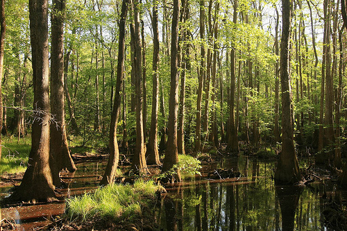
The park's vegetation varies dramatically with elevation and flooding
patterns. In the higher, better-drained areas, towering loblolly pines
dominate the canopy, contributing to one of the tallest temperate
deciduous forests in the world (with some pines exceeding 160–170 feet).
On the floodplain itself, majestic bald cypress and water tupelo trees
prevail, often rising from the water with distinctive "knees" — knobby
root extensions that help with stability and possibly aeration during
floods.
Because the forest was largely spared from commercial
logging, Congaree boasts an extraordinary concentration of champion
trees — the largest specimens of their species in the nation or state.
This includes some of the tallest and widest bald cypress trees
anywhere, with circumferences reaching over 27–30 feet and heights
around 130+ feet (such as the notable state champion bald cypress).
Rangers at the visitor center can provide guidance on locating these
ancient giants. Other common tree species include sassafras, American
holly, sweetgum, various oaks (like laurel oak and cherrybark oak),
hickories, and more, creating a rich, multilayered forest teeming with
biodiversity.
Congaree is a paradise for birdwatchers, with over 200 species
recorded. Pileated woodpeckers are especially abundant and often heard
or seen drumming near the boardwalk trail close to the visitor center.
Smaller songbirds flit through the understory, while wild turkeys,
hawks, and occasional ospreys (particularly along the rivers) add to the
avian diversity.
Mammals are plentiful too: gray squirrels scamper
everywhere, white-tailed deer browse quietly, and coyotes may be heard
howling at night. More elusive species include river otters, bobcats,
and armadillos. However, not all wildlife is benign. Feral hogs
(invasive wild pigs) roam the forest floor, rooting up soil and
vegetation — they're often aggressive, especially protective sows with
young, so exercise caution if you hear grunting or hooves nearby.
American alligators inhabit the park's waters and wetlands, marking one
of the northernmost extents of their range in the region; they're most
often spotted by paddlers in deeper backcountry areas.
Snakes are
common in this warm, humid environment. Venomous species include the
copperhead, cottonmouth (water moccasin), canebrake rattlesnake, and the
rarer coral snake. Always watch your step around warm rocks, logs,
holes, leaf litter, or downed trees, and give snakes plenty of space.
The park's waters teem with aquatic life. Lakes and creeks host numerous
turtles (including snapping turtles), while fish like long-nosed gar,
largemouth bass, perch, sunfish (such as bluegill and redbreast),
crappie, catfish, and others thrive here. With polarized sunglasses, you
can often spot them clearly from the surface.
Fishing is permitted
throughout the park (including from shore or non-motorized boats like
canoes/kayaks), but you must follow South Carolina state regulations,
carry a valid SC fishing license, and adhere to limits. No fishing is
allowed from or within 25 feet of any man-made structures (e.g.,
bridges, boardwalks, or overlooks). Motorized boats are prohibited, and
avoid using live minnows, amphibians, or fish eggs as bait to prevent
introducing nonnative species. Always check current rules at the visitor
center or on the official NPS site, as conditions can vary.
The Harry Hampton Visitor Center serves as the main hub, open daily
from 9 AM to 5 PM (closed on federal holidays). It offers exhibits,
maps, ranger talks, and up-to-date information on trails, water levels,
alerts, and permits (e.g., for backcountry camping or paddling). The
official park website is https://www.nps.gov/cong for planning your
visit, checking current conditions (including flooding, which occurs
about 10 times a year), and exploring virtual resources.
Whether
you're hiking the accessible 2.4-mile boardwalk loop, paddling serene
waterways, or seeking out champion trees, Congaree offers a serene,
biodiverse escape into one of the East's most pristine wilderness areas.
By Car
From downtown Columbia, South Carolina, Congaree National
Park is an easy and scenic 30-minute drive southeast. Head out on Bluff
Road (also known as SC-48), where route numbers are posted but rarely
referenced by locals—instead, watch for clear park signage directing you
toward the entrance. The drive takes you through rural landscapes before
reaching the park's main entrance. If you're planning to stay past 5
p.m. or overnight (for example, for camping or early-morning
activities), use the designated overnight parking area near the park
entrance or the oversized vehicle lot at the Harry Hampton Visitor
Center. Note that sleeping overnight in vehicles anywhere in the park is
prohibited—camping is only allowed in designated frontcountry
campgrounds (with reservations via Recreation.gov) or backcountry areas
(with a free permit).
By Bus
Public transit is available via
The COMET's Route 47 (Eastover/Gadsden ReFlex), which connects various
spots in and around Columbia to the park. The bus stops directly outside
the Harry Hampton Visitor Center, making it a convenient car-free option
for visitors from the city or nearby areas. Check current schedules and
connections on the COMET website or app, as service may vary by time and
day.
Congaree National Park remains completely free to enter—no entrance fees are charged, and no park pass is required for admission. This makes it one of the most accessible national parks. (America the Beautiful passes aren't sold on-site due to the lack of fees, but they can be obtained at other national parks or online.)
After parking in one of the lots (including areas for oversized vehicles), exploration is primarily on foot or by water. The park has no roads beyond the entrance area, so you'll rely on walking trails or paddling. The Harry Hampton Visitor Center and the iconic 2.4-mile Boardwalk Loop Trail are both fully wheelchair- and stroller-accessible, featuring elevated wooden paths that wind through the floodplain forest and offer excellent views without getting muddy or flooded.
The park protects one of the largest remaining tracts of old-growth bottomland hardwood forest in the U.S., featuring primeval landscapes with towering trees (including champion-sized loblolly pines and bald cypresses that can reach over 100–170 feet tall), unique cypress "knees," and incredibly diverse plant and animal life. Expect to spot wildlife like river otters, deer, turtles, wading birds, woodpeckers, and occasionally alligators or bobcats, all thriving in this rich floodplain ecosystem.
Paddling is a highlight here—canoeing and kayaking let you immerse
yourself in the serene wilderness. Check conditions and availability at
the visitor center first, as water levels can vary seasonally (low water
may require portaging around obstacles, while high water can flood
trails). The Cedar Creek Canoe Trail is a marked ~15-mile route through
the Congaree Wilderness, starting near Bannister's Bridge and ending at
the Congaree River. Look for small brown rectangular signs (about 8x4
inches) with white canoe icons placed roughly 12 feet above the
water—note that they're spaced infrequently. A key spot is Myers' Cut
(also called Myzack's Cut) at the lower end of Cedar Creek, which
connects paddlers to the Congaree River. Beyond this point, continuing
up Cedar Creek is challenging due to lack of maintenance, frequent
blowdowns, and strainers (obstacles that can trap boats).
For a
longer adventure, the Congaree River Blue Trail offers a 50-mile
paddling route along the river. The park does not rent canoes or kayaks,
so bring your own or arrange rentals/guided trips through Columbia-area
outfitters (several hold commercial authorizations for guided tours).
Ranger-guided wilderness canoe tours, when offered, are free and
typically scheduled in spring and fall (lasting 3.5–4 hours, limited to
12 people, requiring reservations via Recreation.gov). As of recent
updates, the park is not currently offering these ranger-led trips due
to staffing/scheduling—check Recreation.gov or the park website for
availability, or book with local outfitters like Palmetto Outdoor, J.K.
Adventure Guides, or others for guided options year-round.
In summer,
owl walks (nighttime programs focused on hearing and learning about owls
and other nocturnal life) are often held on Friday evenings—confirm
schedules at the visitor center, as they depend on staffing and season.
Stop by the Harry Hampton Visitor Center's park store, where you'll discover an excellent variety of items. It stocks a solid selection of hiking guides, trail maps, books on the park's unique ecology (like its champion trees and bottomland hardwood forest), educational materials, souvenirs, and national park-themed merchandise. Knowledgeable rangers and staff are usually on hand to offer personalized advice, answer questions about trails, current conditions, or help you plan an itinerary—especially useful if you're exploring South Carolina's hiking scene.
Congaree National Park has no restaurants, cafés, or food vendors inside the park, so plan accordingly. Pack your own meals, snacks, and plenty of water (a must in this humid environment). Vending machines with basic drinks and snacks are available near the visitor center for quick grabs. After a long day of hiking or exploring, head to downtown Columbia (about 20-30 minutes away by car) for a hot meal—options range from casual spots to local favorites offering Southern cuisine, barbecue, or diverse dining.
The park itself offers no hotels, cabins, or lodges. If you didn't
bring camping gear, your best option is heading to downtown Columbia or
nearby areas, where you'll find a range of hotels, motels, and Airbnbs.
Columbia provides convenient access back to the park the next day.
Camping (Frontcountry)
Congaree has two main frontcountry
campgrounds: Longleaf and Bluff, both tent-only (no RVs or trailers).
Longleaf Campground sites are a short walk (up to about 100 yards)
from the designated parking lot, so you won't need to carry gear too
far—great for casual overnight stays.
Bluff Campground requires a
roughly 1-mile hike in (from the visitor center or Longleaf parking),
making it a bit more secluded.
Closer sites, especially those
near the parking area or overnight lot, tend to fill up faster and feel
more crowded. Summer weekends (especially Friday and Saturday nights)
often see groups like local families and Boy Scout troops, so expect
some noise and activity. If you're seeking a peaceful, solo wilderness
vibe, consider hiking farther into the backcountry instead.
Reservations are required for both campgrounds and must be made in
advance through Recreation.gov or by calling 1-877-444-6777—no walk-ups
or on-site payments.
Current fees (note: these have increased since
older info; always check Recreation.gov for the latest):
Longleaf
Campground: Typically $15 per night for a standard tent site; $25 for
group sites.
Bluff Campground: Around $10 per night for hike-in
sites.
Senior and Access Pass holders get a 50% discount on these
fees. Limits apply: no more than 14 consecutive nights or 28 nights in a
6-month period.
Venture deeper into the park's wild interior for a true immersion in
this ancient, almost prehistoric landscape. The terrain is remarkably
flat (old floodplain), but expect muddy, wet conditions
year-round—especially after rain—thanks to the jungly, swampy
environment. The towering trees (some of the tallest in the eastern
U.S.) and abundant wildlife (birds, deer, otters, and more) become even
more impressive the farther you go. Trails are generally well-marked
with reliable maps available at the visitor center. Few visitors stray
beyond the easy boardwalk loops, so you'll often have the deeper areas
to yourself. Cell service remains decent in many spots due to the
proximity to Columbia and flat land.
Backcountry camping is free but
requires a permit. Request one by emailing the park
(cong_information@nps.gov) at least 72 hours in advance—no walk-up
permits. There are no designated sites; choose any suitable spot at
least 100 feet from certain water bodies (like Cedar Creek) and 300 feet
from other groups. Follow Leave No Trace principles, and note that open
fires are prohibited (use a backpacking stove only).
This is a lush, subtropical wilderness, so preparation is key.
Insects: Mosquitoes thrive in the standing water—often intense from
spring through fall (check the "Mosquito Meter" at the visitor center).
Bring strong bug spray, long sleeves/pants, and consider a head net.
Deer ticks (potential Lyme disease carriers) and dog ticks are present;
do thorough tick checks after hikes (for yourself and pets).
Snakes:
Several venomous species (including copperheads, cottonmouths/water
moccasins, and rattlesnakes) live here, but bites are rare if you stay
on trails, watch your step, and leave any snake alone. South Carolina
hasn't reported a fatal snakebite in years—good judgment keeps risks
low.
Alligators: Native to the area, especially near water. Keep a
safe distance (at least 30 feet if seen), never approach or feed them,
and avoid swimming or wading in unknown waters. No recorded gator
fatalities in the state recently, but caution is essential.
General
tips: Wear sturdy, waterproof shoes for mud and snake protection, bring
the Ten Essentials (including first aid, navigation, and extra water),
check current conditions/alerts before heading out, and hike with a
buddy if possible. In an emergency, call 911 (cell service is fairly
reliable but may vary).
Prehistoric and Native American Era (c. 13,000–1700s)
Archaeological evidence shows humans have inhabited the Congaree
floodplain for at least 10,000–13,000 years. Early inhabitants were
nomadic hunter-gatherers who followed large mammals and foraged in
temporary camps. Over millennia, they formed small tribes, built more
permanent villages, developed pottery, and adopted
agriculture—particularly corn, beans, and squash—which supported larger
chiefdoms.
These peoples constructed ceremonial mounds throughout the
floodplain. The land is named for the Congaree people (part of a broader
network including Santee, Wateree, Catawba, and others), who lived here
into the historic period and subsisted on abundant game, vegetation,
fish, and river resources. Native populations faced catastrophic decline
after European contact due to warfare, displacement, and introduced
diseases. The Congaree were largely eradicated during the Yemassee War
(early 1700s), with survivors absorbed into neighboring tribes.
European Exploration and Early Colonial Contact (1540–1700s)
Spanish
conquistador Hernando de Soto explored the area in 1540 (some accounts
note April 1541), encountering the chiefdoms that had met him earlier.
His expedition introduced devastating European diseases and hogs that
persist in the ecosystem today. A follow-up expedition by Juan Pardo
came shortly after. English contact intensified after the 1670 founding
of Charles Towne (Charleston). In 1700–1701, surveyor John Lawson
traveled up the Santee River to the Congaree-Wateree confluence. He
described the Congaree people as “kind and affable to the English,”
noting cultural and linguistic diversity among nearby tribes.
By the
mid-1700s, planters claimed floodplain land via grants for cash crops
like rice and indigo. They built plantations, roads, and ferries
(including McCord’s Ferry, later Bates Ferry) to transport goods to the
coast. Attempts to control flooding with dikes and levees largely failed
due to the river’s powerful seasonal floods.
During the Revolutionary
War era (1770s), South Carolina assumed land distribution rights. The
area saw use by patriots and later became part of routes connecting
Camden and Charleston. Post-war, Governor James Hopkins Adams (served
1839) acquired much of the swamp; after the Civil War, he sold it in
tracts.
Refuge for Enslaved People and Maroon Communities
(1700s–1860s)
The dense, jungle-like floodplain became a refuge for
enslaved Africans escaping plantations. Many chose to live as
maroons—self-emancipated people—in hidden camps rather than risk the
journey north. They faced slave catchers and the challenges of nature
but gained autonomy, hunting, fishing, and sustaining communities near
family and familiar resources. Enslaved labor also built cattle mounts
(earthen platforms for livestock during floods) and other earthworks
that remain visible today. After emancipation, African Americans
continued fishing Cedar Creek, hunting, and using the waters for
baptisms and recreation.
Logging Era and Private Ownership (Late
1800s–Early 1900s)
Post-Civil War industrialization drove demand for
lumber. In the late 1890s, Chicago lumbermen Francis Beidler (owner of
the Santee River Cypress Lumber Company) and Benjamin F. Ferguson
purchased about 15,000 acres of prime floodplain (now called the Beidler
Tract) for bottom dollar. Logging of massive old-growth bald cypress
began in 1898–1899. Logs were cut and floated downstream to mills for
shingles, pilings, and siding. Operations continued for about 15–20
years but proved difficult and unprofitable due to access issues,
waterlogged trees that wouldn’t float, and high costs. The company
ceased major operations around 1915–1917, leaving most hardwood stands
untouched and many sunken logs still visible in creeks and flats.
Beidler and his heirs retained ownership, leasing sections for hunting.
Mid-20th Century: Hunting Clubs and Early Conservation (1940s–1960s)
After World War II, the Beidler Tract was leased for hunting. E.R. Poat
started the United States Game Club for turkey and duck; Marion Burnside
later renamed it the Cedar Creek Hunt Club. Local newspaper editor and
club member Harry R. E. Hampton (co-editor of The State in Columbia)
explored the forest extensively. By the early 1950s, he recognized its
uniqueness as one of the last vast old-growth bottomland forests in the
Southeast. Through his “Woods and Waters” columns and advocacy, Hampton
launched a grassroots campaign to save it from future logging. He
co-founded the Beidler Forest Preservation Association (1961) with state
Senator James Hammond to push for public ownership. A 1963 National Park
Service study recommended a national monument, calling it “the redwoods
of the East.” Initial efforts stalled when the Beidler family refused to
sell.
Renewed Threats and Grassroots Campaign (1969–1976)
A
spike in timber prices in 1969 prompted renewed logging threats on
private lands. This galvanized a new wave of activists. Jim Elder and
Brion Blackwelder formed the Congaree Swamp National Preserve
Association (CSNPA, 1972), partnering with the Sierra Club and others
under the rallying cry “Congaree Action Now!” They lobbied Congress
alongside earlier advocates like Hampton. South Carolina Senators Strom
Thurmond and Ernest F. Hollings introduced legislation. On October 18,
1976, President Gerald Ford signed the bill establishing Congaree Swamp
National Monument (initially about 15,000–22,000 acres focused on the
Beidler Tract). The park was designated a National Natural Landmark in
1974.
Expansion, Wilderness Designation, and Redesignation as a
National Park (1980s–2003)
In 1988, an expansion added acreage (to
roughly 22,200 authorized acres), and over two-thirds was designated
wilderness. The Harry Hampton Visitor Center was dedicated in 2001 in
honor of Hampton’s pioneering efforts. On November 10, 2003, Congress
redesignated the site Congaree National Park (dropping “Swamp” as
misleading), expanded boundaries by about 4,576 acres, and it became the
57th U.S. national park. Today it encompasses over 26,000 acres (with
roughly 26,000 in federal ownership as of the early 2010s), including
15,000+ acres of wilderness.
Modern Cultural and Historical
Legacy
The park protects not only champion trees (tupelo, cypress,
oak, pine) but also cultural resources: archaeological sites, historic
ferry roads (Bates Ferry Trail), dikes, cattle mounts, bridge abutments,
and remnants of maroon camps and plantations. It is listed on the
National Register of Historic Places for these features and holds
additional designations as an International Biosphere Reserve, Ramsar
Wetland of International Importance, Important Bird Area, and
Outstanding National Resource Waters. The landscape tells a continuous
story—from Indigenous chiefdoms to maroons seeking freedom, loggers
harvesting giants, and conservationists who ensured its survival. As one
NPS historian noted, Congaree’s strength lies in its “long, deep, rich,
valued, and even unmarked history” of a place that is both profoundly
natural and deeply cultural.
Topography and Relief
The park features remarkably flat floodplain
topography, with only about 20 feet (6 meters) of elevation change
across nearly 15 miles (24 km)—typically ranging from around 80–140 feet
(24–43 m) above sea level, with an average around 180 feet (55 m) in
broader mapping. Despite this minimal relief, the landscape is
surprisingly varied and complex due to subtle micro-topographic features
created by river dynamics.
Even a few inches or feet of elevation
difference dramatically influences flooding duration, soil saturation,
and vegetation. The terrain includes:
Broad flats and forested
wetlands.
Natural and artificial ridges and levees.
Deep-water
sloughs and slow-moving creeks.
Oxbow lakes and
intermittent/permanent streams.
Low bluffs along the northern edge.
Alluvial fans and rimswamps near the margins.
These features
create a mosaic of habitats within the floodplain complex and river
valley terrace complex.
Hydrologic Features and Floodplain
Dynamics
Hydrology defines the park's geography. The Congaree River
(south boundary) and Wateree River (east boundary above their
confluence) drain a massive ~14,000-square-mile (36,000 km²) watershed
extending into the Piedmont and Appalachians. These "flashy" brown-water
rivers carry high suspended sediment loads and nutrients.
Major
floods inundate up to 90% of the park an average of 10 times per year,
primarily in late winter and early spring (highest river levels then;
lowest in late summer/fall). Floodwaters slow across the flat
floodplain, deposit nutrient-rich silt, sand, and clay, recharge
groundwater, reduce erosion downstream, and rejuvenate the ecosystem.
Tributaries like Cedar Creek, plus features such as oxbow lakes and
sloughs, add complexity.
Groundwater seeps from bluffs create
rimswamps (highly diverse wetland edges), while wetlands and vegetation
(including old-growth tree roots) further slow flows and influence
sediment deposition. Subtle gradients from meandering channels, woody
debris, and past river migrations dictate flooding patterns and plant
communities (22 distinct associations in the floodplain alone, plus 5 on
the bluffs).
Major Landforms and Geomorphic Features
The
dynamic floodplain includes classic fluvial features shaped by river
meandering, cut-bank erosion, and point-bar deposition:
Oxbow
lakes → Formed when meander loops are cut off; examples include Weston
Lake (deepest, ~21+ feet/6+ m, gravel bottom, visible from the
boardwalk), Dead River, Horseshoe Lake, Devil’s Elbow, and Bates Old
River. Many fill gradually with silt, clay, peat, and organics, evolving
into sloughs or cypress-tupelo swamps.
Sloughs and slow creeks →
Deep-water channels that hold water longer.
Levees and ridges →
Natural (from sediment buildup) and man-made (historic).
Rimswamps
and alluvial fans → At floodplain margins, fed by groundwater or
tributary flows (e.g., Muck Swamp near the visitor center holds the
park’s only peat deposits).
Low northern bluffs → Mark the transition
to upland pine forest.
Southern bluffs (just outside the park) →
Eroding and influencing the river.
The park also contains subtle
Carolina Bay-like depressions in some contexts, though the dominant
story is the active Congaree River floodplain.
Geology and
Geologic History
Congaree sits on young Quaternary floodplain
deposits (sand, silt, clay, alluvium) overlying older
Cretaceous-to-Eocene Coastal Plain sediments. The landscape records
river migrations, Pleistocene sea-level fluctuations, and the Augusta
Fault (a reactivated Paleozoic structure trending under the river
valley). Older units include marine and deltaic sands/clays from times
when the shoreline was much closer.
River terraces (estuarine to
fluvial sand/clay) formed during the Pleistocene; modern floodplain
features are Holocene. The forest itself, large woody debris, and human
activities (e.g., legacy sediment) further shape micro-topography.
Paleontological traces (e.g., fossil pollen indicating cooler
savanna-like conditions in the Pliocene/Pleistocene) appear in deposits,
though not a primary geographic driver.
Climate Context
The
park experiences a humid subtropical climate (Köppen Cfa): hot, muggy
summers (highs ~88°F/31°C), short mild-to-cold winters, and consistent
rainfall year-round. This supports frequent flooding and lush vegetation
while influencing soil saturation and ecosystem distribution.
Overall Geographic Significance
The intimate interplay of flat
topography, dynamic hydrology, and fluvial processes creates one of
North America’s most biodiverse temperate forests. Slight elevation
changes and flooding regimes produce a patchwork of communities—from
permanently wet cypress-tupelo swamps to higher-ground oak-hickory and
upland pine savannas on the bluffs (maintained partly by fire).
Nutrient-rich sediments sustain champion trees and wildlife, while the
floodplain acts as a natural flood buffer.