Location: Culberson County and Hudspeth County, TX Map
Area: 86,416 acres (34,971 ha)
Official site
Guadalupe Mountains National Park is a stunning protected area
located in West Texas, near the border with New Mexico, within the
broader Chihuahuan Desert region (often associated with the remote
and rugged landscapes of far West Texas, though distinct from Big
Bend National Park farther south). This park safeguards one of the
world's most extensive Permian fossil reefs, vast desert expanses,
dramatic salt flats, towering peaks, and deep canyons, offering a
unique blend of high-elevation wilderness and arid beauty.
It
features Texas's highest mountains, including Guadalupe Peak (also
known as the "Top of Texas") at 8,751 feet above sea level—the
state's tallest natural point—along with several other prominent
summits over 8,000 feet. The terrain includes rugged, steep trails
through pine forests, canyons with hidden springs, and sweeping
views over the surrounding desert.
The park's official website is nps.gov/gumo, where you can find
detailed planning resources, current conditions, trail maps, and
updates.
Pine Springs Visitor Center serves as the main hub and
headquarters for the park, located in the Pine Springs area near the
primary entrance. Here, visitors can:
Pay entrance and camping
fees
Explore an informative museum highlighting the park's geology,
history, wildlife, and Permian fossil reef
Watch an engaging
orientation slide show or film about the park's features
Browse and
purchase souvenirs, books, and educational items at the park
bookstore/store
Pick up free brochures, trail guides, and detailed
maps
Obtain necessary permits, such as for overnight backpacking or
wilderness camping
This center is an ideal first stop to get
oriented, speak with rangers for advice on hikes (including the
strenuous but iconic trail to Guadalupe Peak), and prepare for
adventures in this remote, high-desert environment. The park emphasizes
self-sufficiency due to its isolated location, so checking weather,
bringing plenty of water, and planning ahead is essential.
The most convenient way to reach Guadalupe Mountains National Park is
by driving, as there is no public transportation or shuttle service
within the park. The nearest major airport with commercial flights is in
El Paso, Texas, roughly 110 miles (about a 2-hour drive) west of the
park's main entrance. From El Paso, take US Highways 62 and 180 east—the
roads are well-maintained and paved, providing a straightforward route
through scenic West Texas desert landscapes.
On the eastern side,
Carlsbad, New Mexico, offers commuter air service (via connections from
Albuquerque) and is approximately 56 miles from the park. Follow US
62/180 southwest from Carlsbad, crossing into Texas, where you'll pass
near Carlsbad Caverns National Park en route to Guadalupe Mountains.
This makes it easy to combine visits to both parks in one trip.
For
those heading to the remote Dog Canyon entrance on the park's northern
side (via New Mexico State Road 137), fill up your gas tank in Carlsbad
or nearby Artesia, New Mexico beforehand. The round-trip drive from
these towns to Dog Canyon takes about two hours and involves hilly
terrain with alternating uphill and downhill grades, which can consume
more fuel than flat highways. Importantly, there are no gas stations
along this stretch or inside the park itself—plan carefully to avoid
running low.
A key safety note for the Dog Canyon road: Exercise
extreme caution, especially on winding sections, and avoid driving it at
night. Guardrails are minimal or absent in many areas, as is common in
rural New Mexico, so poor visibility increases risks significantly.
Entrance fees grant access for 7 consecutive days, with unlimited
re-entry during that period. The standard entrance fee remains $10 per
person (ages 16 and older; children 15 and under enter free). Unlike
many parks that charge per vehicle, this is a per-person fee, so a
family or group in one car pays accordingly (e.g., three adults = $30
total).
The park also offers a $35 Guadalupe Mountains National Park
Annual Pass, valid for one year from the month of purchase and admitting
the pass holder plus passengers in a non-commercial private vehicle (up
to four adults typically covered under broader interagency rules).
Most visitors opt for the America the Beautiful – The National Parks and
Federal Recreational Lands Pass (also known as the Interagency Pass),
which covers entrance to Guadalupe Mountains and over 2,000 federal
recreation sites nationwide, including other national parks, monuments,
wildlife refuges, and forests. It applies to an entire group in a
private vehicle or up to four adults on foot/bike. Key types include:
Annual Pass — $80 for U.S. citizens/residents (non-residents pay
$250 as of 2026 changes); valid 12 months from issue date.
Senior
Annual Pass — $20 for U.S. citizens/residents age 62+.
Senior
Lifetime Pass — $80 for U.S. citizens/residents age 62+.
Military
Annual Pass — Free for current U.S. military members and dependents
(show CAC or Military ID).
Military Lifetime Pass — Free for veterans
and Gold Star families (requires documentation).
Access Pass — Free
lifetime pass for U.S. citizens/residents with permanent disabilities
(documentation required); includes 50% discounts on some amenities like
camping.
Volunteer Pass — Free for those who've donated 250+ service
hours to participating federal agencies.
Every Kid Outdoors 4th Grade
Pass — Free annual pass (September–August of the school year) for U.S.
4th graders and accompanying passengers in a non-commercial vehicle;
requires registration at the Every Kid Outdoors website.
The
National Park Service offers free entrance days in 2026 for U.S.
citizens and residents (other fees like camping may still apply). These
patriotic and commemorative dates include:
February 16
(Presidents Day)
May 25 (Memorial Day)
June 14 (Flag Day /
President Trump's birthday)
July 3–5 (Independence Day weekend)
August 25 (NPS 110th Birthday)
September 17 (Constitution Day)
October 27 (Theodore Roosevelt's birthday)
November 11 (Veterans Day)
Pay fees at the Pine Springs Visitor Center (credit/debit
preferred), self-pay stations at trailheads (using envelopes), or in
advance via Recreation.gov for convenience.
Once inside Guadalupe Mountains National Park, exploration is
primarily on foot or horseback—there are no scenic drives for regular
vehicles beyond access roads. The park features rugged trails for hiking
(including to Guadalupe Peak, Texas's highest point at 8,751 feet) and
limited dirt roads in the desert areas that may require four-wheel-drive
vehicles with high clearance.
The park has three main entrances:
Pine Springs — The primary and most popular entrance along US
62/180, home to the main visitor center, ranger station, museum, park
store, and the largest campground.
Dog Canyon — A quieter, northern
entrance with a small ranger presence and a smaller campground; ideal
for those approaching from New Mexico but more remote.
McKittrick
Canyon — The best access point for exploring the stunning McKittrick
Canyon area, known for its fall foliage, perennial stream, and wildlife.
It features a contact station with interpretive displays (more of an
"outdoor" visitor experience) and trailheads.
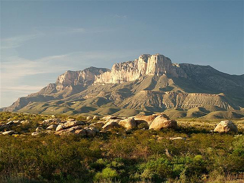
If you're short on time or prefer not to tackle strenuous hikes, you
can still enjoy stunning panoramic views of the Guadalupe Mountains
(often called the "Guads"), especially the iconic El Capitan formation.
These are easily accessible from several pullouts and turnouts along US
Highway 62/180, which runs along the park's southern boundary. The best
spots are typically west of the main park entrance near Pine Springs,
where the sheer cliff face of El Capitan rises dramatically against the
desert landscape—perfect for photos without leaving your car or taking
more than a short walk.
Dog Canyon Ranger Station (also known as the
contact station) serves as a key stop for visitors. It's open year-round
except on December 25th, and here you can pick up free brochures,
detailed maps, and any required backpacking or wilderness permits to
explore deeper into the park.
Must-Do Activities
Guadalupe
Peak — This is the undisputed highlight for hikers, leading to the
summit of Guadalupe Peak (8,751 feet), the highest point in Texas. The
round-trip trail is about 8.4–8.5 miles with roughly 3,000 feet of
elevation gain, typically taking 6–8 hours depending on your pace and
fitness level. Starting from the Pine Springs Campground trailhead, the
well-maintained path offers breathtaking vistas of El Capitan, the
rugged park interior, and vast desert expanses below. It's one of the
park's most popular trails, but don't underestimate its demands: the
steep ascent can be grueling, especially in the initial switchbacks, and
the summit ridge often brings 15–20°F colder temperatures, strong gusty
winds, and occasionally lingering snow or ice patches in winter and
early spring. Loose rock and rubble on sections increase the risk of
slips or ankle injuries, so wear sturdy hiking boots, bring plenty of
water, layers, sun protection, and trekking poles if needed. At the top,
sign the register inside the ammo can to record your achievement—it's a
rewarding tradition!
Entry for day use (including this hike) costs
$10 per person (ages 16 and older; kids 15 and under free), valid for 7
consecutive days. America the Beautiful passes are accepted. Note that
backcountry camping requires a separate wilderness permit (free, but
limited availability), and frontcountry camping at Pine Springs is
available for an additional fee (typically around $8–$20 per night per
site, though check current rates).
McKittrick Canyon — Often hailed
as one of the "most beautiful spots in Texas," this area features a lush
riparian oasis amid the arid Chihuahuan Desert. Hike through vibrant
maple forests (especially stunning in fall with brilliant reds, yellows,
and oranges), pass by Texas' only reproducing trout stream, and visit
the historic Pratt Lodge, the park's original ranch house. The trail
starts gently, following a perennial stream with towering limestone
walls, before options to continue steeply to "The Notch" for sweeping
high-country views. It's a rewarding day hike with diverse
scenery—wildlife sightings, unique plants, and dramatic contrasts
between desert and canyon greenery.
Guided Tours and Ranger
Programs
For first-time visitors or those preferring a hassle-free
experience, consider booking with a local tour operator. Experienced
guides know the park intimately, share insider stories, hidden gems, and
practical tips that enhance your trip. They typically supply essential
safety gear, meals, and water—always confirm details in advance and ask
what personal items to bring (e.g., sturdy shoes, hat, sunscreen).
One option is Lone Star Trekking (☏ +1 979-393-8022), which offers fully
guided four- and five-day backpacking trips through the park. They
provide all necessary gear, equipment, and food, making it ideal for
novices or groups wanting a supported adventure.
The park also hosts
free ranger-led programs on various topics, from geology and wildlife to
history and stargazing. Check the current schedule at the Pine Springs
Visitor Center upon arrival.
No major stores exist inside the park. The nearest options are in Whites City, New Mexico, about 35 miles north of the main entrance (near Carlsbad Caverns). The Visitor Center sells a small selection of souvenirs, books, maps, and basic items.
There are no restaurants, cafes, or food services within or
immediately near the park. Pack all your meals, snacks, and plenty of
water—bring extra, as desert heat can be intense.
Water and
Hydration
Filling stations are available at the main campgrounds
(like Pine Springs) and the McKittrick Canyon trailhead. Always carry
sufficient water for hikes, as sources are limited and unreliable in the
backcountry.
Lodging
Guadalupe Mountains National Park has no lodging
facilities inside the park boundaries. The closest accommodations are in
the small, somewhat kitschy tourist community of Whites City, New
Mexico, located just outside the entrance to nearby Carlsbad Caverns
National Park. This area is approximately 35 miles by road from the main
Pine Springs area of Guadalupe Mountains NP. Options here include places
like the Whites City Cavern Inn (which offers basic amenities such as a
pool and waterslides in some properties), though reviews vary and it can
feel dated or tourist-oriented. For more choices and potentially better
quality, head to the larger town of Carlsbad, New Mexico, about 15 miles
farther east from Whites City (roughly 50 miles total from the park).
Carlsbad has a wider selection of hotels, including chains like Hyatt
House, La Quinta, and others, providing more modern comforts,
restaurants, and services.
Camping in Developed Campgrounds
The
park offers two primary developed campgrounds, both primitive in style
with no hookups, showers, or dump stations available.
Dog Canyon
Campground — Situated at a higher elevation of about 6,300 feet on the
remote northern end of the park (accessible via New Mexico, roughly a
2-hour drive from the main Pine Springs area). It features 9 tent sites
and 4 RV sites (limited to smaller RVs, max length around 23 feet), plus
one reservable group site for 10–20 people. All individual sites are
first-come, first-served, while the group site can be reserved up to 6
months in advance via Recreation.gov. Amenities include potable drinking
water and flush toilets. No wood or charcoal fires are allowed due to
high fire risk—only containerized fuel stoves are permitted. Current
fees are $20 per night per individual site (with discounts to $10 for
Senior/Access Pass holders; no discounts for other passes). This spot is
cooler in summer and more sheltered from winds in cooler months, with a
forested, peaceful feel.
Pine Springs Campground — Conveniently
located just a short drive (about 2 minutes) from the Pine Springs
Visitor Center near the park's main entrance and Guadalupe Peak
trailhead. It has 20 tent sites (gravel, leveled, walk-in with picnic
tables, shaded by junipers and oaks) and 13 RV sites (paved, max length
up to 55 feet). All are first-come, first-served for individuals, with
two reservable group sites for 10–20 people (up to 6 months ahead).
Amenities include potable water (suitable for filling bottles/hydration
packs), flush toilets, and utility sinks (no showers). No fires with
wood/charcoal; only containerized fuel stoves allowed. Fees are $20 per
night per individual site ($10 for qualifying pass holders). This
campground can fill up quickly during peak seasons.
Note: A
separate park entrance fee of $10 per person (age 16+) applies for 7
days, or consider an annual pass if visiting multiple sites.
Backcountry Camping
Much of Guadalupe Mountains National Park is
designated wilderness, with about 80 miles of trails open to hikers and
horseback riders (horses cannot stay overnight in the backcountry).
Overnight backpackers must camp only at one of the 10 designated
primitive campsites, each with 4–8 hardened tent pads (tents must be on
pads; no hammocks or tying to trees). No off-trail camping is permitted,
and there is no water source in the backcountry—plan to carry at least
one gallon per person per day (more in hot weather).
A Wilderness Use
Permit is required year-round for all overnight stays and can be
reserved up to 3 months in advance via Recreation.gov (with a $6
non-refundable reservation fee per permit + $6 per person per night
recreation fee). Walk-up permits are available first-come, first-served
at the Pine Springs Visitor Center (limited hours). Obtaining a permit
guarantees you can camp in the backcountry, but specific sites are not
assigned—first-come basis at the location. Popular sites can fill up,
especially during the last week of October when vibrant fall foliage
peaks. Bigtooth maple leaves turn brilliant reds and oranges in areas
like McKittrick Canyon, creating stunning contrasts against the desert
landscape—peak colors typically mid-to-late October through early
November, drawing crowds (visit mid-week if possible).
Trails start
from Pine Springs or Dog Canyon and are often strenuous with significant
elevation gains (at least 2,000 feet on rocky terrain for most sites).
For solitude, opt for more remote spots like Tejas Campground in the
wooded central highlands—it's a longer hike but offers wind-protected
tent pads amid pines, abundant deer, and high chances of having the area
to yourself. Access from Dog Canyon is slightly longer but involves less
elevation gain.
Summer heat can be intense—always carry ample water (extra on steep trails). Many trails are steep, rocky, and rugged, so wear sturdy, supportive hiking boots with good traction. Layer clothing, as temperatures vary dramatically with elevation (cooler at higher points, windy year-round). Watch for wildlife: rattlesnakes are common but not aggressive unless provoked (they usually rattle as a warning); black bears and mountain lions are rare, avoid humans, and no attacks have been recorded in park history.
Geological Origins
The history of Guadalupe Mountains National
Park begins deep in geological time, rooted in the Permian Period
approximately 272 to 260 million years ago. During this era, the region
was submerged under a vast inland sea known as the Delaware Sea, part of
the larger Permian Basin. This shallow tropical ocean fostered the
growth of the Capitan Reef, a massive barrier reef system composed
primarily of sponges, algae, and other marine organisms like ammonites,
bivalves, brachiopods, crinoids, snails, and trilobites. Over millions
of years, lime deposits from seawater and decaying marine life
accumulated, forming a reef hundreds of feet thick along the shelf of
the Delaware Basin. As the sea receded and sediments buried the reef,
tectonic forces compressed and uplifted the area around 10 to 14 million
years ago, exposing the fossilized limestone through erosion of softer
surrounding rock. Today, the Guadalupe Mountains represent one of the
world's best-preserved and most studied Permian fossil reefs, with the
park preserving the southernmost and highest portion of this range,
including El Capitan and Guadalupe Peak (Texas's highest point at 8,751
feet).
Prehistoric Human Presence
Human history in the
Guadalupe Mountains dates back over 10,000 years, as evidenced by
archaeological finds in the area's numerous caves and alcoves. Early
inhabitants were likely nomadic hunter-gatherers who relied on the
mountains' resources for survival. Artifacts such as pottery, baskets,
spear tips, and rock art suggest seasonal occupation, with people
hunting mammals like mammoths and bison in the surrounding basins and
gathering plants like mescal beans (from which the Mescalero Apaches
derive their name). The mountains provided shelter, water sources in
canyons like McKittrick Canyon, and materials for tools, making them a
vital refuge in the arid Chihuahuan Desert.
Native American Era
and Conflicts
The mountains hold deep cultural significance for
Indigenous peoples, particularly the Mescalero Apaches, who have
inhabited the region for centuries and view the Guadalupes as sacred. By
the 18th and 19th centuries, the Apaches used the rugged terrain for
guerrilla warfare and as a sanctuary against encroaching settlers and
military forces. The area witnessed bloody conflicts, including
skirmishes between Mescalero Apaches and U.S. Army Buffalo Soldiers
(African American regiments) in the late 1800s during the Indian Wars.
These clashes were part of broader efforts to control the Southwest,
with the Apaches resisting relocation to reservations. Other tribes,
such as the Comanche and Kiowa, also traversed the area, using it for
hunting and trade routes.
European Exploration and Westward
Expansion
Spanish explorers first documented the Guadalupe Mountains
in the 16th century, naming them after Our Lady of Guadalupe, a revered
figure in Mexican Catholicism. Expeditions like those of Antonio de
Espejo in 1583 noted the striking peaks, but the harsh desert
environment deterred extensive settlement. In the mid-19th century, the
mountains became a key corridor for westward expansion. The Butterfield
Overland Mail stagecoach route, established in 1858, passed through the
area, with the Pinery Station serving as a vital stop for mail and
passengers en route from St. Louis to San Francisco. The station's
ruins, preserved in the park, highlight this era of frontier travel,
which lasted until the Civil War disrupted operations in 1861. Immigrant
settlers and prospectors followed, drawn by rumors of minerals, though
mining efforts were largely unsuccessful due to the remote, water-scarce
terrain.
Ranching and Settlement
The late 19th and early 20th
centuries saw the rise of ranching in the Guadalupes. Hardy settlers
established operations like the Frijole Ranch (built around 1876) and
the Williams Ranch, adapting to the arid conditions by developing
spring-fed irrigation systems for orchards and livestock. These ranches
represent the grit of frontier life, with families enduring isolation,
droughts, and conflicts with Apaches. By the early 1900s, larger cattle
operations dominated, but the Great Depression and overgrazing led to
land degradation. Wallace Pratt, a petroleum geologist working for
Humble Oil (later Exxon), discovered the area's beauty in the 1920s
while surveying for oil. Enchanted by McKittrick Canyon, he purchased
land in the 1930s, building a stone cabin (now the Pratt Cabin) as a
vacation home. Pratt's appreciation for the geology and scenery would
later prove pivotal.
Path to National Park Status
Efforts to
preserve the Guadalupe Mountains as a protected area began in the 1920s.
In 1921, Harold J. Brodie, a Canadian visitor, proposed a national park
focused on the scenic El Capitan and Guadalupe Peak. Initial surveys by
the National Park Service (NPS) in the 1930s considered linking it to
nearby Carlsbad Caverns, but the idea evolved to recognize the
Guadalupes' unique merits. Post-World War II, conservation momentum
grew. Wallace Pratt donated 5,632 acres, including McKittrick Canyon, to
the federal government in 1959 and 1963, emphasizing the site's
scientific value as a fossil reef. Additional land acquisitions,
including from rancher J.C. Hunter Jr., followed amid challenges like
securing mineral rights and combining fragmented parcels. Congress
authorized the park on October 15, 1966, under Public Law 89-667, citing
its outstanding geological features, scenic beauty, and ecological
diversity. Guadalupe Mountains National Park was officially established
on September 30, 1972, encompassing approximately 86,367 acres (though
early figures cited 76,293 acres due to boundary adjustments) in
Hudspeth and Culberson counties, Texas. From 1972 to 1987, it was
administered jointly with Carlsbad Caverns National Park, with ground
broken for a visitor center in 1988.
Modern Era and Preservation
Since its establishment, the park has focused on protecting its cultural
and natural resources. The 50th anniversary in 2022 celebrated its role
in preserving history, from ancient reefs to ranching relics. Artifacts
must remain undisturbed to maintain interpretive value, with federal
laws prohibiting collection. The park now includes eight of Texas's ten
highest peaks and draws visitors for hiking, birdwatching, and
stargazing in its dark skies. Ongoing challenges include climate change
impacts on its fragile desert ecosystem and balancing recreation with
conservation.
Guadalupe Mountains National Park, established in 1972, spans
approximately 86,367 acres (135 square miles) in the remote Chihuahuan
Desert of west Texas, east of El Paso and just south of the New Mexico
state line along U.S. Highway 62/180. The park protects the southernmost
and highest portion of the 40-mile-long Guadalupe Mountains range, which
extends northeast into New Mexico and is surrounded by the South Plains
to the east and north, the Delaware Mountains to the south, and the
Sacramento Mountains to the west. This isolated fault-block mountain
range rises dramatically from the arid desert floor, creating a stark
contrast between low-elevation salt flats and high peaks. The park's
remoteness contributes to its low visitation, making it a haven for
hikers and geologists, with over 80 miles of trails traversing diverse
landscapes.
Geological History
The geography of Guadalupe
Mountains National Park is profoundly shaped by its origins as part of
the Permian Basin, a vast sedimentary region formed during the Permian
Period (about 250-300 million years ago). At that time, the area was
submerged under the Delaware Sea, an ancient inland ocean where marine
organisms built the Capitan Reef—a 400-mile-long, U-shaped fossil reef
complex, one of the best-preserved Permian reefs in the world. This
reef, composed primarily of limestone from sponges, algae, and other
non-coral organisms, was uplifted through tectonic forces, including a
major fault that elevated the western escarpment up to 3,600 feet in
places like Shumard Canyon. Over millions of years, erosion exposed the
reef's layers, revealing Guadalupian-age strata (270-260 million years
old) that include intercalated carbonate and sandstone beds. The park
serves as a Global Boundary Stratotype Section and Point (GSSP) for
Middle Permian time, highlighting its international geological
significance. Fragments of this reef system are also visible in nearby
ranges like the Apache and Glass Mountains.
Topography and
Landforms
The park's topography is characterized by rugged, uplifted
marine fossil reefs forming a monolithic wall-like escarpment that rises
more than 3,000 feet above the surrounding desert. Elevations vary
dramatically, from lows of about 3,630 feet at the western sand dunes
and salt flats to a high of 8,751 feet at Guadalupe Peak, the tallest
point in Texas. The western escarpment is particularly striking,
featuring steep cliffs, deep canyons, and one of the thickest exposed
sequences of Permian strata on Earth. To the west, the piedmont includes
alluvial fans, bajadas (coalesced alluvial fans), and extensive salt
flats formed by faulting and erosion. The eastern side slopes more
gradually, with desert scrublands transitioning into higher-elevation
woodlands.
Climate and Ecosystems
The park lies in the arid
Chihuahuan Desert, with low annual precipitation (about 10-20 inches,
mostly in summer monsoons) and extreme temperature swings—from below
freezing in winter to over 100°F in summer. However, the high elevations
create "sky islands" with cooler, moister conditions, supporting diverse
ecosystems. Lowlands feature desert scrub (creosote bush, yucca) and
salt flats, while mid-elevations have grasslands and riparian zones in
canyons with perennial streams. Higher areas host conifer forests,
providing habitat for species like mule deer, mountain lions, and over
300 bird species. This elevation-driven biodiversity includes relict
forests in places like The Bowl, contrasting sharply with the
surrounding desert.
Hydrography and Human Impact
Surface water
is scarce, limited to intermittent streams and springs in canyons like
McKittrick and Pine Spring. No major rivers traverse the park, but
groundwater from the ancient reef supports oases. Human geography
includes historic ranching sites and Native American archeological
features, with the park's wilderness area (over 46,800 acres) preserving
its pristine state. The ruggedness and isolation deter large-scale
development, maintaining the park's geological integrity.