Location: from Natchez Mississippi to Nashville, Tennessee
Total Length: 440 miles (710 km)
The Natchez Trace Parkway is a 444-mile (715 km) limited-access scenic byway and national park unit administered by the U.S. National Park Service (NPS). It commemorates the historic “Old Natchez Trace,” an ancient travel corridor that stretches from Natchez, Mississippi (milepost 0), northeast through Mississippi, a short stretch of Alabama, and into Tennessee, ending just south of Nashville (near milepost 444). Established in 1938 as part of the New Deal and fully completed in 2005, the Parkway offers a peaceful, two-lane recreational road with no commercial traffic, no billboards, a 50 mph speed limit (40 mph in some sections), and over 50 access points. It preserves more than 10,000 years of North American history while providing an unhurried journey through rolling landscapes, forests, swamps, and cultural sites.
Prehistoric and Native American Origins (c. 10,000+ Years Ago)
The
Trace began as animal paths—bison, deer, and other game followed a
natural geologic ridge line for dry footing, access to salt licks in
Middle Tennessee, and the Mississippi River. Early humans followed these
trails for hunting, trading, and gathering. Over millennia, Native
American groups, including ancestors of the Mississippian culture
(builders of mound complexes), the Natchez, Choctaw, and Chickasaw
nations, improved and used the network extensively.
The route passed
through their homelands and connected major settlements. Archaeological
evidence includes over 350 sites along the modern Parkway, such as 22
burial and ceremonial mounds (e.g., the massive Emerald Mound, the
second-largest in the U.S.). Pharr Mounds near Tupelo, Mississippi, date
back about 2,000 years. The Chickasaw and Choctaw called sections by
names like “Piominko’s Path” (after Chickasaw chief Piomingo/Mountain
Leader). Creeks, Cherokees, Shawnees, and others also traveled it for
hunting and trade. The Trace was not a single straight line but a series
of interconnected paths that could vary up to 100 miles longer than
today’s route, often detouring along streams for water and food.
European Exploration and Early Contact (16th–18th Centuries)
Spanish
explorer Hernando de Soto traversed portions in 1540–1541, moving from
the Gulf Coast northward into Chickasaw territory (southern Tennessee),
where his forces clashed with the Chickasaw before his death. French
explorers followed in the 18th century, establishing trading posts and
forts; one expedition under d’Artaguette was defeated by the Chickasaw
near the Trace. British settlers were often welcomed for their
relatively peaceful approach compared to Spanish and French ambitions.
Europeans introduced horses, which some Native groups adopted for faster
travel.
The first recorded full traversal by a European was an
unnamed Frenchman in 1742, who described the rugged, “miserable”
conditions. By the late 1700s, the Trace had become a vital link between
the Cumberland settlements (Nashville area) and the Mississippi River
port of Natchez. Chickasaw leaders like Piomingo forged alliances with
American settlers for trade and defense, further defining the northern
section as “Piominko’s Trace.”
Development into a Postal and
Wagon Road (1790s–1810s)
After American independence, the Trace
gained national importance. In the 1790s, U.S. mail riders began using
it (up to 50 miles/day on horseback; express riders hit 100 miles).
President John Adams designated it a postal route in 1800. In 1801,
President Thomas Jefferson ordered the U.S. Army to improve it into a
wagon road—“the Columbian Highway”—as part of linking the western
frontier to the East. Treaties with the Chickasaw and Choctaw allowed
construction.
Soldiers and contractors cleared a 16-foot-wide path (8
feet smooth for wagons), built bridges, causeways, ferries (e.g.,
Colbert’s Ferry over the Tennessee River, Duck River ferry), and stands
(inns) for travelers. Choctaw Agent Silas Dinsmoor traveled it by buggy
in 1805. The army initially let Native groups operate many ferries and
stands (e.g., George Colbert). By 1809, wagons could navigate the full
route; northward trips took 2–3 weeks. A French visitor predicted one
could eventually ride a carriage from Boston to New Orleans. The Trace
became known locally as the Natchez Road, Nashville Trace, or “Devil’s
Backbone” due to its isolation.
The Heyday: Kaintucks, Stands,
and Commerce (1770s–1820s)
The Trace’s peak came after the
Revolutionary War. “Kaintucks” (flatboat men from Kentucky, Ohio,
Pennsylvania, and the upper Mississippi Valley—often called “Kaintucks”
regardless of origin) floated goods downstream to Natchez and New
Orleans, sold their boats for lumber, and returned overland on foot or
horseback with profits in their pockets. Around 1810, an estimated
10,000 used it annually. The journey north took about 35 days on foot
through wilderness.
“Stands” (inns) sprang up—about 50 operated at
peak—offering hominy, bacon, biscuits, coffee, whiskey, blacksmithing,
and floor space for sleeping. Famous ones included Mount Locust (still
standing), Grinder’s Stand, Gordon’s Stand, and Joslin’s. The Trace
spread news, religion (Methodist, Baptist, and Presbyterian circuits
grew rapidly), and ideas. It also became part of the “Slave Trail,” with
enslaved people forcibly marched south to Natchez’s markets; slave
traders like Andrew Jackson (pre-presidency) and firms such as Franklin
& Armfield used it. Enslaved travelers faced extra perils, including
kidnapping by bandits for resale or ransom.
Outlaws, Dangers, and
Legends
The remote, forested route attracted highwaymen. Notorious
gangs included the Harpe Brothers (Micajah and Wiley), Samuel “Wolfman”
Mason, and John Murrell. They robbed, murdered, and sometimes mutilated
victims; travelers carried cash or goods, making easy targets. Stories
of buried treasure, ghost lights, and haunted spots (e.g., Witch Dance)
emerged. Disease, weather, and wildlife added risks. Many travelers
vanished. The area around Natchez Under-the-Hill was especially lawless.
Military Uses and Key Figures
The Trace served as a military
corridor. During the War of 1812 and Creek War, General Andrew Jackson
marched troops south and later returned sick soldiers from Natchez to
Nashville in 1813 (with baggage wagons). Jackson had earlier used it for
slave trading and married Rachel near the Trace. Meriwether Lewis (of
Lewis and Clark fame), then governor of the Louisiana Territory, died
mysteriously at Grinder’s Stand in 1809—officially ruled suicide
(possibly opium-related), though his mother suspected murder; he is
buried there (now a Parkway site).
In 1838–1839, several Cherokee
detachments on the Trail of Tears crossed the Old Trace en route west
(Benge, Bell, Drane, and Water Routes). The Parkway crosses these routes
in four places; many Cherokees walked segments before boarding boats or
continuing overland. An estimated 4,000+ Cherokee died during the
removal.
The Trace saw limited Civil War use (skirmishes near it;
battles at Brices Cross Roads and Tupelo are managed by the Parkway).
Decline (1830s Onward)
Steamboats revolutionized river travel
after the 1810s–1820s, allowing cheap upstream transport and rendering
the overland Trace obsolete. The 1830s Indian removals (Choctaw,
Chickasaw, Cherokee) and new roads (e.g., Jackson’s Military Road)
further reduced traffic. By the 1840s, most stands closed; the Trace
fragmented into county roads. It survived locally but lost national
prominence—“a victim of its own success” in opening the Southwest.
Establishment of the Natchez Trace Parkway (1930s–Present)
Interest revived in the early 1900s. In 1938, Congress designated the
Natchez Trace Parkway as a National Park Service unit to commemorate the
historic corridor (one of the few parkways honoring an ancient route).
Civilian Conservation Corps and Public Roads crews began construction in
the 1930s (Great Depression era); the full 444-mile road was completed
in 2005. It roughly follows the historic path, preserving segments of
the “Sunken Trace,” mounds, stands, and archaeological sites across
52,000 acres in Mississippi, Alabama, and Tennessee. In 1996 it became a
National Scenic Byway and All-American Road; a separate Natchez Trace
National Scenic Trail (66 miles of hiking/horse paths) was added in
1983. Sites like Meriwether Lewis’s grave (incorporated 1961) and Civil
War battlefields are included.
Today, the Parkway offers a peaceful
drive through 10,000 years of history, with interpretive stops, hiking
trails, and preserved “stands.” It connects 25 counties and 20
communities while protecting forests, wetlands, prairies, and cultural
resources.
The Parkway traverses three states: approximately 270 miles in
Mississippi, about 50 miles in Alabama, and 124 miles in Tennessee. It
winds through cypress swamps and farmland in the south, Appalachian
foothills and hardwood forests in the north, and crosses the Tennessee
River. Ecosystems include bottomland hardwood forests, piney woods,
oak-hickory stands, wetlands, and limestone springs. Wildlife sightings
commonly include white-tailed deer, armadillos, raccoons, opossums,
beavers, numerous bird species, and reptiles. Wildflowers and fall
foliage are especially spectacular.
A standout natural stop is the
Cypress Swamp (milepost 122 in Mississippi), where a boardwalk leads
through a flooded forest of towering bald cypress trees with their
distinctive “knees.”
Witch Dance (Milepost 233.2, near Tupelo, Mississippi)
The single
most famous supernatural landmark on the entire Trace is a picnic area
and campground called Witch Dance. A roadside sign still marks the spot.
According to Choctaw and later settler lore, a coven of witches (or, in
some versions, Native “medicine women” practicing dark rites) met here
on moonlit nights. As they danced in a circle, wherever their bare feet
touched the ground the grass instantly withered and died, leaving
permanent blackened circles that “never grow again.”
Even today,
visitors report seeing scorched, barren patches in the grass that refuse
to green up. On full-moon nights, people claim to hear distant chanting,
beating drums, evil screeching, and wailing. One persistent tale says
the notorious outlaw Micajah “Big” Harpe once mocked the witches by
leaping from bare spot to bare spot, daring them to fight him. The
witches are said to have cursed him—perhaps explaining why his
decapitated skull was later ground into powder for a healing potion.
Park rangers still host lantern-led “Haunting Stories” walks here every
October.
The Harpe Brothers — America’s First Documented Serial
Killers
Micajah “Big Harpe” and his cousin Wiley “Little Harpe”
(sometimes called the first American serial killers) slaughtered at
least 40 people along the Trace in the 1790s, often for sport. They
disemboweled victims, filled the cavities with rocks, and sank the
bodies in rivers; they murdered infants by bashing their heads against
trees; they even killed a man simply because his snoring annoyed them.
Big Harpe was finally cornered and beheaded in Kentucky in 1799. His
head was nailed to a tree along the Trace as a warning. Legend says a
witch later stole the skull, ground it to powder, and used it in a
potion that healed her sick relative. Ever since, travelers report
hearing maniacal cackling laughter coming from the bushes and pine
thickets. Big Harpe’s headless ghost is said to walk the Trace
eternally, still searching for victims. Little Harpe was hanged in 1804;
both brothers’ spirits are blamed for the malevolent red-headed man in a
top hat who appears inside King’s Tavern.
King’s Tavern —
Natchez’s Most Haunted Building
In Natchez, Mississippi (the southern
terminus), King’s Tavern (one of the oldest buildings in the state,
dating to the 1780s) served as a notorious inn, tavern, and post office
for Trace travelers and river pirates. It is among the most actively
haunted sites associated with the Trace.
The most famous ghost is
Madeline, a beautiful 16-year-old server and mistress of owner Richard
King. Jealousy (from Mrs. King or thugs) led to her murder; her body,
along with two men’s, was bricked into a chimney. In the 1930s,
renovations uncovered mummified remains. Her spirit is playful yet
mischievous: apparitions, footprints, poltergeist activity (knocking
jars, moving objects), and a crying baby (possibly a Harpe victim or
another murdered infant) have been reported. A menacing red-headed man
in a top hat—possibly Samuel Mason or a Harpe—appears, along with
shadowy figures on stairways and unexplained heat from fireplaces.
Outlaws like the Harpes and Mason frequented the tavern, leaving a
legacy of violence that fuels the hauntings.
Devil’s Punchbowl,
Natchez-Under-the-Hill, and Other Outlaw Haunts
Devil’s Punchbowl, a
mysterious geological depression near Natchez and the Mississippi River,
served as a hideout for bandits like Joseph Thompson Hare (who claimed
over 100 murders and buried loot plus his murdered mistress’s body
there). A sinister presence, apparitions of Hare’s laughing ghost, and
the mistress are reported; Hare himself saw the phantom white horse on
the Trace before his 1818 hanging.
Natchez-Under-the-Hill, the rowdy
riverfront district at the Trace’s start, was a den of brothels,
saloons, and shootouts. Ghosts of outlaws, gamblers, and victims lurk
amid its violent past.
Other outlaws include:
Samuel “Wolfman”
Mason (“Land Pirate”): Operated gangs robbing Trace travelers and
riverboats; killed by Little Harpe; head returned for reward.
John A.
Murrell (“Great Western Land Pirate,” 1806–1844): Led the “Mystic Clan”
in the 1830s, counterfeiting, horse theft, and scams (including fake
slave-freeing plots); legends of buried treasure and a planned slave
rebellion empire persist, though his direct Trace activity was less
central than the Harpes’.
Other Ghosts, Graves, and Treasures
13 Unknown Confederate Graves: Along the Old Trace in Mississippi (near
Rodney/Alcorn State area), far from battlefields. Angry spirits of
soldiers who died in a confusing skirmish are said to resent visitors at
night.
Mount Locust Inn (Milepost 15.5): Ghosts of “Kaintuck Six”
(plundered boatmen) who now “ghost-war” to protect modern travelers.
Windsor Ruins (near the Trace): Majestic antebellum columns; peaceful
congregation of spirits rather than malevolent ones.
Antebellum
Mansions and General Trace Ghosts: Previous owners haunt their homes;
weary travelers’ and outlaws’ spirits wander the entire route.
Buried Treasures: Pirate loot (from river pirates), Civil War soldier
caches, and Murrell/Harpe/Mason hoards are legendary, though rarely
found—adding to the allure of metal-detecting or nighttime searches.
Over 100 interpretive sites line the route, marked by mileposts. Here
are some of the most significant (grouped roughly northbound):
Mississippi (mileposts 0–310-ish)
Emerald Mound (MP 10.3): The
second-largest prehistoric ceremonial mound in the United States (built
c. 1400 by ancestors of the Natchez). It covers nearly eight acres at
its base and rises 35 feet; visitors can climb stairs to the flat top.
Mount Locust (MP 15.5): One of the oldest surviving stands (c. 1780),
once an inn for Trace travelers.
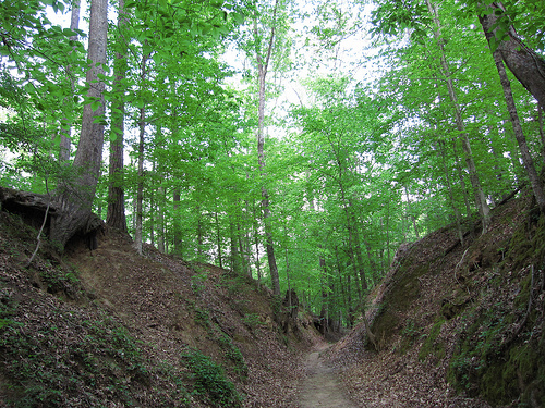
Sunken Trace (MP 41.5) and Rocky
Springs (MP 54.8): Sections of the original sunken roadbed and the
abandoned townsite with a historic cemetery and church ruins.
Cypress
Swamp (MP 122) — as shown above.
Pharr Mounds (MP 286.7): Eight large
dome-shaped burial mounds from the Middle Woodland period (c. 2000–1800
years ago).
Chickasaw Village Site (MP 261.8): Exhibits on Chickasaw
life and the 1736 Ackia Battle.
Alabama (brief section around MP
310–340)
Colbert Ferry (MP 327.3): Site of a historic stand and ferry
across the Tennessee River; short trails lead to river overlooks.
Tennessee (mileposts ~340–444)
Rock Spring (MP 330.2): Short
nature trail to a bubbling limestone spring with fish and varied
vegetation.
Fall Hollow Waterfall (MP 391.9): One of two waterfalls
on the Parkway; a short (slippery) trail leads to a viewing platform
beside the 20-foot cascade.
Meriwether Lewis Monument & Gravesite (MP
385.9): Marks the burial place of the famed Lewis and Clark explorer
(died 1809 at Grinder’s Stand). The 1848 monument honors him; a small
museum and trails are nearby.
Old Trace Drive (MP 375.8): A short
section of the original Trace road you can drive.
Gordon House (MP
407.7): Restored 1818 brick home and ferry site, one of the few
surviving private residences from the Trace era.
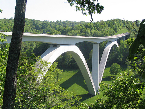
Double Arch Bridge
(MP 437–438) — as shown earlier.
Additional nearby sites (within
40 miles) include Tupelo National Battlefield, Brices Cross Roads
National Battlefield Site, and Natchez National Historical Park.
Parallel to the Parkway are five sections of the Natchez Trace National Scenic Trail (a separate NPS unit) offering hiking and horseback riding on original Trace segments and new paths. Short interpretive trails, picnicking, fishing, birding, and camping are available. Bicycle touring is popular (the Parkway is an official bicycle route with pull-offs and bike-only campgrounds). The Parkway Visitor Center in Tupelo, Mississippi (MP 266), is open daily with exhibits, films, and rangers.
The Parkway is open year-round with no entrance fee. Campgrounds (e.g., Jeff Busby) and facilities exist, but check ahead. Pets are allowed on leashes. A major construction project has closed the section from milepost 181–204 (including Jeff Busby Campground) for pavement and culvert replacement; the closure is expected to extend into 2026—use detours or plan accordingly. Drive cautiously; the road has narrow shoulders in places and is popular with cyclists.