Location: San Juan County Map
Area: 318 acres (1.3 km2)
Constructed: 11th- 13th centuries
Aztec Ruins National Monument, located in northwestern New Mexico near the city of Aztec in San Juan County, is a UNESCO World Heritage Site preserving one of the most significant Ancestral Puebloan archaeological sites in the American Southwest. Spanning 318 acres along the Animas River, the monument protects a 12th-century Chacoan great house, numerous smaller structures, and artifacts that illuminate the sophisticated culture of the Ancestral Puebloans, often misnamed “Aztec” by early settlers who mistakenly linked the ruins to Mesoamerican civilizations. Established as a national monument in 1923 and expanded in 1928, 1930, and 1988, it is managed by the National Park Service (NPS) and attracts approximately 50,000 visitors annually. The site’s well-preserved masonry, ceremonial kivas, and reconstructed Great Kiva offer a tangible connection to a thriving regional center from 1100 to 1300 CE, reflecting Chaco Canyon’s influence and the broader Ancestral Puebloan legacy.
Aztec Ruins National Monument, located near the town of Aztec in
northwestern New Mexico along the Animas River, preserves one of the
best-preserved and most significant examples of Ancestral Puebloan
(formerly called Anasazi) architecture and community planning in the
American Southwest. Despite its name, the site has no connection to the
Aztec civilization of central Mexico—the misnomer arose from
19th-century Euro-American settlers and explorers who romantically (and
incorrectly) attributed the ruins to the Aztecs or their ancestors
migrating northward.
The monument protects a large planned settlement
built primarily in the 12th and 13th centuries CE by Ancestral Pueblo
people. It served as a ceremonial, administrative, and trade center,
functioning as a northern “outlier” of the influential Chaco Canyon
culture to the south (about 65 miles away), with later ties to Mesa
Verde traditions to the north. Today, it encompasses about 318 acres,
features a self-guided trail through the West Ruin and reconstructed
Great Kiva, and is part of the larger Chaco Culture World Heritage Site.
It remains sacred to many modern Pueblo, Navajo, and other Indigenous
peoples.
Prehistoric Construction and Occupation (ca. Late
1000s–Late 1200s CE)
Ancestral Pueblo people began planning and
building the community in the late 1000s CE, drawn to the reliable water
of the Animas River for farming in the arid San Juan Basin. Tree-ring
(dendrochronology) dating—pioneered in part with samples from the
site—reveals that the main construction of the West Ruin (the largest
and most prominent great house) occurred rapidly in episodic phases
between roughly 1110 and 1115 CE, with major building peaks around 1111
and 1118 CE. Overall construction spanned ca. 1085–1120 CE for the core,
with remodeling continuing into the mid-1200s; the last dated beam is
from 1269 CE. The East Ruin was built later, with most activity in the
1200s.
The settlement included:
Great houses like the E-shaped
West Ruin, estimated at 450–500 rooms across up to three stories (walls
originally up to 30 feet high in places), surrounding a central plaza.
It featured advanced Chacoan-style core-and-veneer masonry (rubble core
faced with carefully shaped sandstone), T-shaped doorways, and precise
astronomical alignments (e.g., for solstices).
Kivas (circular
ceremonial chambers): Numerous small family/clan kivas plus the massive
Great Kiva in the West Ruin plaza (originally ~48 feet in diameter, one
of the largest in the Southwest).
A rare tri-walled structure at the
Hubbard Site (early 1100s), with three concentric walls enclosing 22
rooms around a central kiva—likely ceremonial.
Smaller residential
pueblos, earthworks, roads (connected to Chaco’s prehistoric road
system), and possible irrigation ditches along the river.
Early
phases show strong Chacoan influence in architecture, ceramics (e.g.,
black-on-white pottery), and ceremonial styles. By the mid-1200s, after
Chaco’s regional decline around 1130 CE, the site evolved with Mesa
Verde-style features like subdivided rooms and sunken kivas.
The
community supported agriculture (corn, beans, squash) via the river and
possible canals. Population estimates suggest fewer than 300 people
lived year-round in the great house itself (initially perhaps more a
ceremonial/administrative hub), with most residents in surrounding small
structures. Artifacts include pottery (showing cultural transitions),
stone/wood tools, cotton/feather textiles, fiber sandals,
turquoise/shell jewelry (indicating long-distance trade), and food
remains. Some burials were found under floors or in middens.
The site
flourished for nearly 200 years as a thriving hub before abandonment
around 1300 CE. Reasons likely included prolonged drought, shorter
growing seasons from climate change, resource depletion (e.g., timber,
game), and social/political shifts. Residents migrated south, southeast,
and west; their descendants include today’s Pueblo peoples (e.g., Hopi,
Zuni, Rio Grande Pueblos).
Rediscovery and Early Euro-American
Encounters (19th Century)
The ruins were well-known locally but first
formally documented by geologist Dr. John S. Newberry in 1859, who noted
walls still standing up to 25 feet high. Anthropologist Lewis H. Morgan
visited in 1878 and estimated significant stone removal by then. By the
late 19th/early 20th centuries, looting and pot-hunting were common,
though private ownership (H.D. Abrams homesteaded 160 acres in the late
1800s) helped limit damage.
Scientific Excavations and
Preservation (Early 20th Century)
In 1916, the American Museum of
Natural History (AMNH) sponsored the first major scientific excavations.
Earl Halstead Morris (1889–1956), a pioneering Southwestern
archaeologist, directed the work at age 25. Over seven seasons
(1916–1923), his teams excavated and stabilized much of the West Ruin
(dozens of rooms and kivas), the Great Kiva (unearthed 1921), and parts
of the East Ruin. They uncovered rich collections of artifacts—many
perishables like textiles and baskets preserved unusually well—and sent
most to the AMNH in New York (some remain on display at the park’s
visitor center, housed in Morris’s former on-site residence).
Morris,
whose interest in archaeology began as a child, also contributed wood
samples that advanced dendrochronology. In 1933–1934, he returned to
supervise the reconstruction of the Great Kiva for the National Park
Service—one of the few fully restored great kivas anywhere, giving
visitors a vivid sense of its original appearance and communal function.
Later work included 1950s excavations at the Hubbard tri-wall mound and
limited probes at the East Ruin. Modern NPS policy emphasizes
preservation over new large-scale digs, respecting the site’s sacred
status to descendant communities and allowing future techniques to study
unexcavated portions.
Establishment as a National Monument and
Modern Era
On January 24, 1923, President Warren G. Harding
proclaimed it Aztec Ruin National Monument (changed to “Ruins” in 1928
after boundary adjustments) to protect the site “for the enlightenment
and culture of the nation.” Much of the land was donated by the AMNH or
purchased from the Abrams heirs. It expanded over time and was
administratively listed on the National Register of Historic Places in
1966.
In 1987, it became part of the Chaco Culture World Heritage
Site (UNESCO), recognizing its role in preserving exceptional Ancestral
Pueblo engineering and cultural achievements. The monument celebrated
its centennial in 2023.
Today, the NPS manages it with a focus on
stabilization, interpretation, and visitor education. There is no
entrance fee. A half-mile self-guided trail leads through the West Ruin,
the reconstructed Great Kiva, and other features. The East Ruin and
other mounds are largely unexcavated or closed to protect them. The site
draws tens of thousands of visitors annually and contributes to the
local economy while fostering connections to living Indigenous
traditions.
Aztec Ruins National Monument, located along the Animas River in
northwestern New Mexico near the town of Aztec, preserves one of the
finest examples of Ancestral Puebloan (also called Anasazi or ancient
Pueblo) monumental architecture in the American Southwest. This Chacoan
outlier community was built primarily between the late 1000s and
mid-1200s CE by Ancestral Pueblo people with strong cultural and
architectural ties to Chaco Canyon (about 65 miles south). The site
features large, planned “great houses” — multi-story public buildings
with hundreds of interconnected rooms surrounding central plazas — along
with ceremonial kivas, rare tri-wall structures, roads, earthworks, and
landscape modifications. It was designated part of the Chaco Culture
World Heritage Site in 1987 due to its exceptional preservation of
Chacoan engineering and design.
The architecture reflects
sophisticated planning, organized labor, long-distance resource
procurement, and symbolic elements (including astronomical alignments).
Construction was rapid and episodic compared to Chaco Canyon sites, with
the main West Ruin largely completed in about 30 years. Two distinct
masonry styles appear: early Chaco-style (fine, precise) and later Mesa
Verde-influenced (larger blocks, different coursing). Visitors can
explore much of the West Ruin via a half-mile self-guided trail,
including original 900-year-old wooden beams, T-shaped doorways,
preserved plaster, and the only fully reconstructed great kiva in the
Southwest.
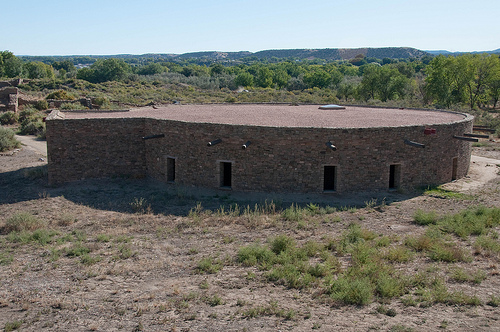
Aztec West Great House (Primary Structure)
This is
the centerpiece and most accessible ruin — a massive, roughly E-shaped
(or D-shaped) great house enclosing a central plaza. It originally
contained at least 400–500 interconnected rooms (some sources cite over
500), many averaging about 10 by 12 feet, rising up to three stories
high (with walls reaching 30 feet in places). The north wall stretches
over 360 feet. It included numerous small kivas (circular ceremonial
chambers) embedded in or adjacent to rooms — estimates range from about
24–30 total kivas within the complex.
The great house was built
around an open plaza dominated by the Great Kiva. Rooms served
residential, storage, and ceremonial functions, though the structure was
likely more of a public/administrative/ceremonial center than purely
domestic. Later phases (McElmo style in the late 1100s and Mesa Verde
style in the mid-1200s) involved renovations: demolishing some rooms,
inserting blocked-in kivas, subdividing spaces, and adding sunken kivas
to upper stories.
Aztec East Ruin and Other Structures
The
East Ruin is a similar but slightly later great house (major
construction in the 13th century), also with connected rooms around a
plaza that once held a large (unreconstructed) great kiva. The North
Ruin is smaller and stable but less excavated. Scattered smaller
residential pueblos, earthen platforms, berms, and road segments
(including traces of a North Road aligned with Chaco) extended the
community across terraces and bottomlands.
Construction
Techniques and Materials
Ancestral Pueblo builders used
core-and-veneer masonry, a hallmark of Chacoan architecture:
Core:
Rubble (loose stone and debris) filled the interior.
Veneer:
Precisely shaped blocks of local marine sandstone (quarried from nearby
formations, including decorative green sandstone from the Nacimiento
Formation about three miles away) faced both sides in alternating thick
and thin horizontal courses. Bands of different-colored stone created
aesthetic patterns. The veneer was not strongly bonded to the core,
which created some structural weakness over time.
Mortar and Finish:
Thick adobe (mud) mortar and plaster covered the surfaces; some original
plaster remains, occasionally preserving ancient fingerprints.
Timber elements were impressive feats of logistics. Beams (vigas) and
smaller poles (latillas) for roofs and floors came from distant
mountains 20–50+ miles away: ponderosa pine, spruce, Douglas fir, aspen,
piñon, juniper, and cottonwood. Many original 900-year-old timbers
survive in ceilings and roofs, making the site one of the best
tree-ring-dated in the Southwest. Rooms often had flat roofs supported
by primary beams, with layers of saplings, splints, and earth on top.
Other features include T-shaped doorways (common in Puebloan
architecture for both practical and symbolic reasons) and evidence of
astronomical alignments in wall orientations and features.
The
Reconstructed Great Kiva
The West Ruin’s Great Kiva — North America’s
largest reconstructed example — is the site’s architectural and
interpretive highlight. Originally built around A.D. 1110–1120 and
excavated in 1921 by Earl H. Morris, it was fully reconstructed in
1933–1934 using original evidence (charred beams, post holes, etc.). It
is semi-subterranean (partially below ground level), circular, about
41–48 feet in diameter at the floor, and designed for large community
ceremonies.
Key interior features (visible today):
Thick
perimeter masonry walls, originally plastered (lower sections red, upper
white).
Four massive square masonry pillars (about 2 feet per side),
each seated on four stacked limestone disks (sourced ~40 miles away,
weighing ~355 lbs each) on a lignite foundation. These supported a
central square of heavy beams.
Radiating beams (like spokes) from the
center to the walls, supporting a flat roof estimated at ~95 tons,
covered with layers of saplings, juniper splints, and earth.
Central
firepit (with ventilation system for smoke).
Other ritual features
like a sipapu (symbolic entrance to the underworld) and benches.
Two
or more encircling surface-level rooms with exterior doors and ladder
access down into the kiva proper.
The reconstruction allows
visitors to enter and experience the scale, acoustics, and engineered
airflow.
Tri-Wall Structures (e.g., Hubbard Site)
One of the
rarest features is the Hubbard Tri-Wall structure (excavated 1953),
located a short walk from the West Ruin. It consists of three concentric
circular masonry walls divided by interior partitions into 22 small
rooms surrounding a central kiva. Similar (but rarer) structures appear
at a few other Chacoan sites like Pueblo del Arroyo. Their exact
function remains unclear but likely involved specialized ceremonies or
elite use.
Preservation and Visitor Experience
Much of the
West Ruin remains standing to first- and second-story levels, with some
third-story elements. Original wooden roofs are intact in places, and
the site’s stabilization preserves the monumental scale. The
architecture demonstrates advanced engineering: precise stonework,
load-bearing design, resource transport networks, and integration with
the landscape for visual and symbolic impact.
Aztec Ruins encapsulates key themes:
Chacoan Influence: As a
northern outlier, it extended Chaco’s religious and trade networks, with
artifacts like macaw feathers linking it to Mesoamerica.
Mesa Verde
Transition: The shift to Mesa Verdean architecture reflects cultural
adaptation amid environmental stress.
Ancestral Puebloan Legacy: The
site’s masonry, kivas, and irrigation systems showcase engineering and
social complexity, influencing modern Puebloan communities.
Preservation Challenges: Early looting and the “Aztec” misnomer
highlight 19th-century cultural misunderstandings, while Morris’s work
pioneered scientific archaeology.
Indigenous Continuity: Consultation
with tribes ensures the site’s story respects living descendants,
countering historical erasure.
West Ruin: A self-guided, 0.5-mile trail (30–60 minutes) explores
400+ rooms, with intact T-shaped doorways and original wooden beams
(1111 CE). Accessible sections include Room 185, with 900-year-old
plaster.
Great Kiva: The 1934 reconstruction, 40 feet wide and 10
feet deep, is the largest of its kind, with interpretive signs
explaining rituals. Visitors can enter to envision ceremonies.
East
Ruin: Unexcavated but visible, with 200+ rooms and 28 kivas, viewable
from overlooks.
Hubbard Tri-Wall Structure: A rare, three-walled
kiva, partially excavated, suggesting unique ceremonial use.
Museum
and Visitor Center: Houses 3,000+ artifacts (pottery, sandals, jewelry),
a 15-minute film, and a replica kiva. Open daily 8 a.m.–5 p.m. (until 6
p.m. Memorial Day–Labor Day, closed major holidays).
Trails and
Events: The 0.75-mile Animas River Trail connects to riverside
cottonwoods. Ranger-led talks, summer solstice alignments, and Puebloan
cultural demonstrations enrich visits.
The monument is open
year-round, with spring (April–May) and fall (September–October) ideal
for mild weather (50–75°F). Summer highs reach 90°F, winter lows 20°F,
with occasional snow. Admission is $6/adult (2025), free for children
under 16, and America the Beautiful Passes ($80/year) apply.
Aztec Ruins National Monument is a 318-acre (129 ha) protected area
in San Juan County, northwestern New Mexico, encompassing well-preserved
Ancestral Puebloan ruins set within a distinctive river-valley
landscape. It lies on the western bank of the Animas River, directly
within the modern city limits of Aztec (the town was named after the
ruins), approximately 12 miles (19 km) northeast of Farmington and about
9 miles from Bloomfield. Its precise coordinates are roughly 36°50′09″N
107°59′53″W.
The monument occupies a strategic position in the
broader San Juan Basin, a large structural depression (part of the
Colorado Plateau physiographic province) that formed during the Laramide
Orogeny (roughly 75–40 million years ago) as the Rocky Mountains rose.
This basin is a sedimentary basin filled with thick layers of Mesozoic
and Cenozoic rocks, bounded by uplifts and volcanic fields to the north.
The site sits between two major Ancestral Puebloan centers—Chaco Canyon
about 65 miles south and the Mesa Verde area about 50 miles
north—highlighting its role in a regional cultural network.
Topography and Landforms
The local topography is defined by the
Animas River valley, a broad, flat-bottomed fluvial corridor with
stepped river terraces rising from the river’s edge. Elevations within
the monument range from about 5,630 feet (1,716 m) at the river level to
5,820 feet (1,764 m) on the northern terrace (slightly broader regional
figures note terrace steps up to ~2,165 feet above the modern valley
floor in places). The ruins themselves sit on Quaternary alluvial
terrace deposits—flat, elevated former floodplains formed by river
incision.
Three distinct strath terraces (erosional benches capped
with alluvium) have been identified in the vicinity, recording repeated
cycles of river downcutting and aggradation tied to glacial-interglacial
climate shifts. The landscape transitions from the active floodplain and
low terraces near the river, through formerly irrigated middle lands
(now being restored to native vegetation), to higher, ungrazed terraces
with grasslands. Gentle slopes and low hills surround the site, with the
river’s eastern boundary marked by riparian vegetation and occasional
bluffs.
Geology and Geologic History
The underlying bedrock is
the Nacimiento Formation (Paleocene, ~65 million years old), consisting
of gray, green, and purple claystone, shale, and siltstone interbedded
with gray and yellow sandstone. These are nonmarine continental deposits
laid down in ancient river, floodplain, and lake environments. Outcrops
are limited within the monument, but the formation underlies the entire
area and was a local source of building stone and clay.
Overlying
this are Quaternary deposits, primarily alluvial terrace gravels,
cobbles, and sands carried by the Animas River. These include glacial
outwash from the Pleistocene Animas Glacier—one of the largest glaciers
bordering the Colorado Plateau. During the late Pleistocene, glaciers
originating from an ice field in the San Juan Mountains (southwestern
Colorado) extended down the Animas Valley, depositing moraines as far
south as Durango, Colorado, and outwash material that was later reworked
by the river into terraces extending to the Farmington area. This
glacial legacy created the fertile, flat terraces ideal for settlement
and farming.
Soils include windblown loess deposits (up to 3 feet /
0.9 m thick) rich in clay, which help retain moisture—an important
factor for prehistoric agriculture. Alluvial fan deposits and younger
floodplain sediments add further complexity.
Hydrology
The
Animas River—a perennial stream originating in the San Juan Mountains of
Colorado—forms the monument’s eastern boundary and was central to its
geography and human occupation. It provided a reliable year-round water
source in an otherwise arid region, enabling Ancestral Puebloans to
construct irrigation ditches for maize, beans, and squash. The river
carries a mix of cobbles and gravels from upstream igneous and
metamorphic rocks, contributing to the alluvial terraces.
A modern
feature is the Farmers Ditch (built in 1892), which runs east-west
through the park and diverts river water seasonally (March–October) for
downstream use. It creates a narrow riparian corridor even as
prehistoric ditches have largely been obscured or integrated into the
modern system.
Climate
The monument experiences a classic
semi-arid climate (Köppen classification BSk). Average annual
temperature is approximately 51.4°F, with mean daily highs ranging from
about 46°F in January to 94°F in July, and lows from 17°F to 58°F.
Annual precipitation averages 8–10 inches (sources cite ~8.2–10.06
inches), mostly as summer thunderstorms, with about 11 inches of
snowfall. This dry, sunny regime with cold winters and hot summers
shaped vegetation patterns and made the river’s reliable flow especially
valuable.
Vegetation and Ecosystems
Despite its small size and
surrounding urban development, the monument supports diverse habitats
due to topographic and hydrologic variation. Along the river and ditches
at the lowest elevations is riparian vegetation dominated by native
cottonwoods and willows, mixed with invasive Russian olive. Higher
terraces feature Upper Sonoran desertscrub transitioning to native
grasslands, with piñon pine and juniper woodland on the upper, ungrazed
areas. Previously farmed lands are being restored from irrigated
pasture/fruit orchards to native desertscrub.
This mosaic—riparian,
grassland, and woodland—supports high biodiversity relative to the
area’s size, including numerous plant species adapted to the loess-rich,
moisture-retaining soils.
The NPS stabilizes masonry annually, addressing erosion from rain and freeze-thaw cycles. Climate change increases flood risks along the Animas, with a 2015 mine spill highlighting vulnerabilities. Visitation (50,000/year, up 20% since 2010) strains trails, prompting limits on group sizes (40 max). Vandalism is rare, but the NPS monitors petroglyphs and unexcavated sites. Tribal partnerships ensure culturally sensitive interpretation, with Hopi and Zuni advisors shaping exhibits. The 2022 Infrastructure Investment and Jobs Act funded trail upgrades and kiva stabilization, ensuring longevity.
Aztec Ruins National Monument, in Aztec, New Mexico (near Farmington
in the Four Corners region), preserves a major ancestral Puebloan
(Ancestral Pueblo) great house complex built in the late 1000s–1200s CE.
It features over 400 rooms in the main West Ruin, a reconstructed Great
Kiva, and connections to Chaco Canyon culture. As a UNESCO World
Heritage Site, it offers an accessible, intimate experience compared to
larger sites like Chaco or Mesa Verde. A typical visit lasts 1–2 hours.
Getting There and Hours
Address: 725 Ruins Road, Aztec, NM 87410
(within town limits, easy to reach).
Directions: About 15 miles
northeast of Farmington via US 550/NM 516. Well-signed and
straightforward.
Hours: Grounds, trails, picnic areas, and parking
open daily 7 AM–5 PM (extended to 6 PM in summer some years). Visitor
center (museum, film, shop) open 9 AM–5 PM. Closed Thanksgiving,
Christmas, and New Year’s Day. No after-hours access without special
events.
Fees: Free entry (no charge since 2018). America the
Beautiful Pass not required but accepted for other benefits.
Pro
tip: Arrive early or late in the day for better light, fewer crowds, and
milder temperatures. The site is compact, so plan 1–2 hours minimum; add
time for the museum and film.
What to Expect and How to Visit
Start at the Visitor Center: Rangers provide orientation. Explore the
museum with artifacts (tools, pottery, jewelry, food remains—no flash
photography). Watch the 15-minute film Aztec Ruins: Footprints of the
Past (hourly/half-hourly, with closed captions), which includes
perspectives from archaeologists, Navajo, and Pueblo people.
Self-Guided Aztec West Trail (Main Activity): Half-mile paved loop
through the West Great House. Walk through original rooms (some
multi-story with intact timber roofs), doorways, and the impressive
reconstructed Great Kiva (largest and oldest of its kind, over 40 feet
in diameter). Trail guides (print booklet ~$2 or QR code download)
explain stops with archaeology and Native perspectives. Stay on the
trail—do not climb walls.
Highlights: Skillful masonry, the Great
Kiva (enter via antechamber; stairs to floor), tri-wall structures.
Time: 30–60 minutes.
Accessibility: Mostly
wheelchair/stroller-friendly with some slopes, benches, and paved
sections. Not all rooms/doorways are accessible (low/narrow doorways,
steps). Borrow wheelchairs at visitor center. Large-print/Braille guides
and audio tours available. Tactile models in VC.
Other On-Site
Activities:
Heritage Garden and Native Plants Walk: In the shady
picnic area—traditional crops and useful wild plants.
Old Spanish
National Historic Trail segment: Short walk from picnic area across
Animas River bridge toward downtown Aztec (can be muddy).
Ranger
Programs: Free talks, tours (May–Sept), Indigenous arts festivals,
dances in the Kiva, plant walks, etc. Check the NPS calendar.
Junior
Ranger: Free booklets for kids (and adults); earn a badge/patch.
Pets: Not allowed on trails (service animals only).
Practical
Visiting Tips
Best Time to Visit:
Fall (Sept–Nov): Mild weather,
golden cottonwoods, pleasant for walking. Often recommended.
Spring:
Can be windy.
Summer: Hot (can exceed 100°F/38°C); visit early
morning. Ranger programs peak.
Winter: Cold nights (down to
0°F/-18°C), possible snow; quieter but trails open.
Shoulder seasons
or weekdays avoid any minor crowds.
Weather and Packing:
High
desert climate: Hot days, cool nights, intense sun, possible afternoon
thunderstorms.
Essentials: Water (no reliable sources on trail),
sunscreen, hat, sturdy/comfortable shoes (paved but some uneven spots),
layers, rain jacket.
Bring snacks/lunch for picnic area.
Health and Safety: Easy trail but watch for steps/slopes. High elevation
(~5,600 ft) — stay hydrated. No climbing or off-trail wandering to
protect fragile ruins.
Photography: Great golden-hour light on stone
walls. No restrictions noted beyond no-flash in museum.
Crowds and
Time: Rarely crowded; self-paced. Combine with nearby sites for a full
day.
Nearby Attractions and Logistics
In Town: Aztec Museum
and Pioneer Village (2 miles), historic downtown Aztec via trail.
Short Drive: Salmon Ruins (12 mi), Navajo Lake State Park (25 mi) for
boating/camping, Angel Peak Scenic Area (BLM, views).
Longer: Chaco
Culture NH P (65 mi), Mesa Verde NP (85 mi), Four Corners Monument.
Lodging: Hotels in Aztec (Comfort Inn, Best Western) or
Farmington/Bloomfield. RV/camping at nearby state parks, BLM sites, or
private RV parks (e.g., Ruins Road RV Park).
Food: Limited at the
monument—eat in Aztec or Farmington.
Overall Advice: This is one
of the most accessible and well-preserved Pueblo great houses, ideal for
history buffs, families, or anyone passing through the Four Corners.
Pair it with a broader ancestral Pueblo itinerary. Check the official
NPS site (nps.gov/azru) for current alerts, calendar, and conditions
before visiting, as weather or staffing can affect programs.