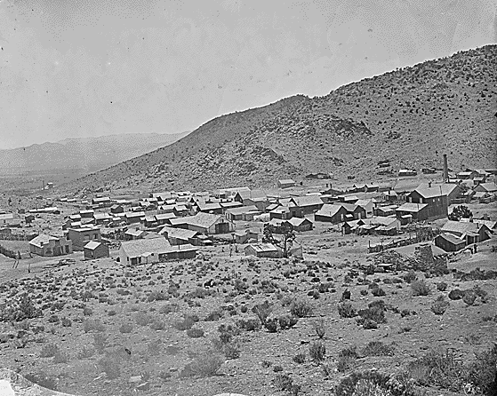
Belmont in 1871
Location: 46 miles Northeast of Tonopah off State Route 376, NV Map
Found: 1865
Belmont Ghost Town, nestled in the remote high desert of Nye County, central Nevada, stands as a poignant relic of the Silver Rush era, embodying the fleeting boom-and-bust cycles that defined the American West. Founded in 1865 following a major silver discovery in the Toquima Range, Belmont rapidly evolved from a cluster of prospector tents into a thriving mining hub and county seat, peaking at an estimated population of 2,000 to 10,000 residents in the 1870s. At its zenith, the town buzzed with economic vitality, producing over $15 million in silver, copper, lead, and antimony ore through six nonstop-operating mills, supporting a diverse array of businesses from saloons and newspapers to a music hall that drew national entertainers. Today, with a scant few residents clinging to its edges, Belmont is a National Register of Historic Places district (listed in 1972) and Nevada Historical Marker #138, offering visitors a haunting glimpse into 19th-century frontier life amid crumbling adobe and brick ruins, a towering mill chimney scarred by World War II target practice, and a preserved courthouse that whispers of rowdy gunfights, lynchings, and vigilante justice. Spanning a dusty 10-block area at an elevation of about 7,800 feet, the site attracts history buffs, photographers, and off-road enthusiasts seeking solitude in Nevada's vast, arid landscape—far from modern amenities, with no electricity, gas, or services nearby—making it an ideal day trip from Tonopah or a rugged adventure for those prepared for the isolation.
Belmont, Nevada, is one of the Silver State’s most iconic and
well-preserved ghost towns—a “living” historic district in Nye County,
about 45 miles (roughly 45–60 minutes) northeast of Tonopah via paved
and dirt roads (US-6, SR 376, and SR 82). Founded in 1865 after a major
silver strike in the Silver Bend (later Philadelphia or Transylvania)
Mining District, it boomed in the late 1860s–1870s as a silver, copper,
lead, and antimony mining hub. At its peak, the population reached
around 2,000, making it the second-largest town in Nevada after Virginia
City. It became Nye County’s seat in 1867, complete with a bank, school,
post office, saloons, restaurants, newspapers (Belmont Courier),
telegraph, assay office, and more.
The town sits at about 7,400 feet
in the scenic high-desert landscape of the Toquima Range, with views of
the Monitor Valley. Mining declined sharply by the late 1880s due to
falling ore yields and competition from richer strikes elsewhere. The
county seat moved to Tonopah in 1905, and the post office closed (with a
brief reopening). Many residents stripped wooden buildings for lumber
when they left, but stone-and-brick structures endured. Today, Belmont
is a National Register of Historic Places historic district (listed
1972, Nevada Historical Marker #138) with a small permanent population,
private homes, and a handful of businesses. It feels frozen in the 19th
century—perfect for history buffs, photographers, and off-grid
explorers. All properties are private or protected; respect boundaries,
take only photos, and leave artifacts untouched.
A self-guided
walking tour (available via the Friends of the Belmont Courthouse)
covers numbered stops with ruins, homes, and mills. Guided courthouse
tours run seasonally (May–September weekends or by appointment). Belmont
is completely off-grid—no services, gas, or food nearby (stock up in
Tonopah). A public campground sits west of the mills.
1. Belmont
Courthouse (1876) – The Crown Jewel
The two-story Italianate-style
brick courthouse with its striking white cupola and red metal roof is
Belmont’s most photographed and iconic landmark. Built in 1875–1876 for
$22,000 on the site of the town’s first mill (using locally made bricks
and quarried stone), it housed county offices, a large courtroom, jury
room, judge’s chambers, and (originally) jail cells. A grand July 4,
1876, celebration marked both the nation’s centennial and the building’s
completion. It served as the Nye County seat until 1905.
The roof
remained intact (unlike most buildings), and the structure survived
decades of abandonment and vandalism. Nevada State Parks managed it from
1974–2012; today, the nonprofit Friends of the Belmont Courthouse
oversees ongoing restoration (new roof, windows, stabilization) to
return it to its 19th-century glory. The interior walls are covered in
historic graffiti—names, poems, and drawings from the 1920s–1960s,
including an alleged carving by Charles Manson and his followers (who
reportedly tried to camp inside; the signature remains but the story is
unconfirmed). Jail cells were removed to Gabbs but later returned and
are viewable on-site.
2. Mill Ruins – Echoes of Industrial Mining
Belmont’s economy revolved around ore-processing mills in East Belmont.
Their stone foundations, retaining walls, machinery scraps, and
especially the towering chimneys are dramatic ruins:
Monitor-Belmont Mill (also called Molitor or Monitor Mill, 1873/1878): A
large wooden structure operated by the Monitor and Belmont Mining
Companies. It was remodeled multiple times; the last major ore shipment
was in 1889. Its prominent chimney is a landmark visible for miles—one
of the best-preserved mill features. During WWII, Tonopah Army Airfield
pilots used it for target practice with .50-caliber guns.
Combination
Mill (1867): A 40-stamp mill built by the Combination Mining Company
(which also built the Combination Building). It processed sulfide ores
via crushing, roasting, and mercury amalgamation. Two tall smokestacks
carried pollutants downwind. It closed quickly (by 1868), was remodeled
in 1878–1879, and machinery was later moved. Brick from it was reused in
the 1915 flotation mill.
1915 Monitor Belmont Mining Company
Flotation Mill: Built with salvaged brick; operated briefly before
tailings were reprocessed by cyanide methods.
Visitors can wander
these sites (respect fencing) and imagine the roar of stamps and
smoke-filled skies.
3. Bank Building (c. 1868) and Early Civic
Structures
This one-story brick building with a basement originally
housed a bank. It later served as a temporary courtroom and sheriff’s
office. The basement held jail cells where, in 1874, vigilantes hung
suspected horse thieves/gunmen Jack Walker and Charles
McIntyre—prompting some “rougher elements” to leave town. It’s one of
the earliest substantial structures and illustrates Belmont’s rapid
shift from tents to permanent civic buildings.
4. Other Notable
Buildings and Ruins Along Main Street and Beyond
Philadelphia House /
Combination Building (1867): Large stone structure at the head of Main
Street, built as offices for the Combination Mining Company’s
superintendent. Later a lodging house, Belmont Inn, and saloon (also
housed the newspaper office). One of the best-preserved and
longest-occupied buildings—now private but a highlight of the tour.
Cosmopolitan (1867–1930s): Two-story wooden saloon, dance hall,
restaurant, and upstairs rooms on Main Street. Operated continuously for
decades; a social hub in the boom years.
Homes and Residences:
Brick/stone houses like the Ernst House (1870s, surveyor family), Leon
House (brick home of a prominent miner), Esser House (shoemaker/grocer
family), Doctor’s House (Dr. James Riddle, 1868), and the House of
Tasker Oddie (1899 home of the future Nevada governor and U.S. Senator).
Many still stand amid fruit trees or private yards.
School House:
Community-built after a 1867 fundraiser ball; now weathered ruins where
children learned the “3 R’s.”
Printing Office / Belmont Courier:
Housed in an early building; one of two local newspapers chronicling the
boom.
Belmont Church (replica, 2001): Modern rebuild of the 1872 St.
Stephen’s Catholic Church (original moved to Manhattan in 1906). Sits on
a hill overlooking town.
5. Belmont Cemetery
Perched on a hill
with panoramic views, this peaceful, well-maintained graveyard (in use
since ~1869) features graves from the boom era, including many children
and miners. Surrounded by sagebrush, juniper, and pines, it offers a
somber counterpoint to the town’s lively past.
Visiting Today
A few businesses add life: Dirty Dick’s Belmont Saloon (a
generator-powered, authentic backcountry bar serving classics like Picon
Punch), Susie’s Attic (antiques), and Sticks and Stones (jewelry). Some
residents live in restored or new homes among the ruins. It’s a
photographer’s dream at sunrise/sunset, with the courthouse glowing
against the mountains. Combine with nearby Manhattan ghost town or
Monitor Valley petroglyphs for a full day.
Pre-Mining Era and Indigenous Use
Long before Euro-American
settlement, the area served as a gathering place for the Western
Shoshone people. The reliable spring supported rabbit drives and
seasonal celebrations, turning the high-desert site into a seasonal hub
in an otherwise arid landscape.
Founding and the 1865–1866 Silver
Rush
Belmont sprang to life in 1865 after the discovery of rich
silver ore in what became known as the Silver Bend (or Philadelphia)
Mining District. High-grade surface ore assayed as high as $3,000 per
ton, sparking a rush in 1866 that pulled miners away from established
camps like Austin. The town grew rapidly as prospectors, merchants, and
laborers poured in. It was named Belmont (“beautiful mountain” in
French/Italian), reflecting its scenic setting amid pinyon-juniper
hills.
Other minerals—copper, lead, and antimony—were also extracted,
but silver drove the initial boom. By 1867, Belmont had a post office
and was designated the county seat of Nye County (previously at Ione), a
status it held until 1905.
Peak Boom Years (1870s)
At its
height in the 1870s, Belmont was a bustling mining center with an
estimated population of around 2,000 (rumors of 15,000 are widely
dismissed as exaggerated, given Nye County’s overall low population at
the time). It featured a full suite of frontier amenities: schools,
churches, two newspapers, a bank, stores, restaurants, saloons, a
Cosmopolitan Music Hall that hosted national entertainers, a Chinatown,
a red-light district, and even a racetrack.
Six mills processed ore,
including the Combination Mill, Canfield’s Mill (1871), Monitor-Belmont
mills, and Cameron mills. The district produced an estimated $15 million
in total ore value between 1866 and 1887 (with silver production alone
cited around $4 million from high-grade but relatively shallow
deposits).
The town had a diverse, international workforce and a
reputation for rowdiness. Saloon brawls, vigilante actions, shootings,
and feuds were common. A notable 1867 riot at the Highbridge Saloon saw
a mob seize mine superintendent R.B. Canfield, “rail” him through town
on a wooden rail, and spark a shootout; former Austin City Marshal Lewis
M. Bodrow intervened and was killed (along with another man, Patrick
Dignon). Vigilante hangings, including of two members of the “601” gang,
reportedly occurred in the courthouse basement.
Notable figures
associated with early Belmont include gunman Jack Longstreet, future
Nevada governor Tasker Oddie, prospector Jim Butler (later tied to
Tonopah), and Andrew Maute.
The Courthouse and Civic Life
The
two-story brick Nye County Courthouse, completed in 1876 (construction
began 1875 under architect J.K. Winchell with a modest state grant),
became the town’s enduring landmark. It served as the seat of county
government until the silver boom shifted to Tonopah. The building still
stands largely intact, with its distinctive cupola, and is now cared for
by the nonprofit Friends of the Belmont Courthouse (transferred back to
Nye County in 2012 after a period as a state park).
Decline and
Bust (Late 1880s–Early 1900s)
By the late 1880s, the shallow
high-grade ores were largely exhausted, and most mines became
unprofitable. The boom faded; residents drifted to newer strikes in
White Pine County and elsewhere. By 1900 only a handful of businesses
remained. The county seat officially moved to Tonopah in 1905 following
its massive silver discovery. Tailings were reworked in 1907–08, and a
brief revival occurred during World War I with the construction of the
Highbridge mill, but the post office closed for good in 1922.
Many
wooden buildings were dismantled for lumber elsewhere, leaving brick and
stone ruins. Population dropped to just 28 by the 1940 census, though
the town was never completely abandoned.
20th Century and Later
Echoes
During World War II, pilots from the nearby Tonopah Army Air
Field reportedly used the towering chimney of the Monitor-Belmont Mill
for .50-caliber machine-gun target practice. In the late 1960s, local
legend (unconfirmed but persistent) claims Charles Manson and his
followers tried to camp in the empty courthouse; longtime resident
“guardian” Rose Walter (c. 1894–1987) allegedly ran them off, and Manson
is said to have carved his name inside.
Modern Belmont: A Living
Ghost Town
Today, Belmont is a popular destination for history buffs,
photographers, and off-roaders. It remains off-grid—no electricity, gas,
or services—so visitors must come prepared. Three businesses operate
seasonally: Susie’s Attic (antiques), Sticks and Stones (jewelry), and
the atmospheric Dirty Dick’s Belmont Saloon, a classic “sagebrush
saloon.”
The courthouse is open for self-guided or occasional guided
tours (May–September weekends), and a walking tour takes visitors past
mill ruins, saloon remnants, and other historic structures. The
combination of preserved architecture, dramatic high-desert setting, and
tangible mining history makes Belmont a standout among Nevada’s ghost
towns—less ruined than many, yet authentically frozen in the 19th
century.
Belmont, Nevada, is a historic ghost town and unincorporated
community in Nye County, central Nevada, situated in a classic
high-desert mountain setting within the Basin and Range physiographic
province of the Great Basin region.
Coordinates: approximately
38.595°N, 116.876°W (or more precisely 38°35′42″N 116°52′34″W).
It
lies about 46 miles northeast of Tonopah (the current Nye County seat)
via Nevada State Route 376, with access to the site itself along the
former State Route 82. The town sits roughly 70 miles south of Austin,
in a remote area known for its scenic but rugged backroads.
Regional and Topographic Setting
Belmont occupies the eastern slopes
and a sloping plateau of the Toquima Range, a north-south trending
mountain range typical of Nevada’s Basin and Range
topography—characterized by elongated, fault-bounded ranges separated by
broad, arid valleys (basins). The Toquima Range extends about 71 miles,
with peaks reaching over 11,000 feet farther south (e.g., Mount
Jefferson). To the east lies the Monitor Range, with Monitor Valley in
between; the Hot Creek Range and Hot Creek Valley are also nearby to the
east.
The immediate terrain around Belmont is hilly to mountainous,
with steep slopes, high plateaus, and rocky outcrops. Local elevations
in the Belmont area (Belmont East/West USGS quadrangles) average around
7,375 feet, ranging from roughly 6,985 feet (valley floors or lower
slopes) to 7,969 feet (nearby ridges). The town site itself sits at
approximately 7,400–7,424 feet (about 2,260–2,263 meters).
This
mid-to-high elevation gives Belmont a less barren feel than many lower
Nevada desert ghost towns. The landscape features open vistas of
surrounding ranges, with sagebrush-filled valleys and forested slopes
visible in the distance.
Hydrology and Natural Features
A
reliable year-round spring was the key geographic draw for both
indigenous Shoshone people (who used the site for gatherings and rabbit
drives) and later miners. Water is scarce in the Great Basin, so this
perennial source was crucial for settlement in an otherwise arid
environment. Nearby drainages include Belmont Creek and its tributaries
(featured on USGS 7.5-minute topographic maps like the Belmont Creek
quadrangle). Surface water is limited, with no major rivers—typical of
the closed basins of the Great Basin, where streams often end in playas
or evaporate.
Climate
Belmont experiences a cold semi-arid
high-desert climate (influenced by its elevation and interior
continental position). Annual precipitation averages about 7.8–10
inches, mostly as winter snow or spring rains, with occasional summer
thunderstorms. The wettest month is typically January. Summers are mild
to warm (daytime highs can reach the mid-90s°F), while winters are cold
(lows often in the 20s°F or below), with significant diurnal temperature
swings due to low humidity and clear skies. Snowfall occurs in winter,
and the area sees sharp seasonal contrasts.
This climate, combined
with the elevation, supports a more temperate feel than the hotter
lowlands around Tonopah.
Vegetation and Ecosystems
The
surroundings fall into a pinyon-juniper woodland ecosystem, with
juniper, pinyon pine (“nut pine”), and sagebrush dominant. Historically,
the area had ample local wood and building materials (uncommon for
Nevada mining camps), which supported construction of substantial brick
and wood-frame buildings. This woodland contrasts with the sparser
sagebrush steppe in lower valleys.
Geology
Belmont lies within
the Belmont Mining District in the Toquima Range. The geology features
complex assemblages of Paleozoic sedimentary rocks intruded by igneous
bodies, with mineralized veins containing silver, gold, copper, lead,
and antimony—the basis for the 1865 silver boom. Detailed USGS geologic
quadrangle maps (Belmont East and West) document faults, folds, and
volcanic influences typical of the region’s tectonic history. The Basin
and Range extension has created the prominent mountain blocks and
valleys seen today.
Belmont's allure lies in its tangible remnants, frozen in time by the dry climate that has spared many structures from rapid decay. The star is the Belmont Courthouse, a two-story red-brick edifice built in 1876 at a cost of $9,000 (about $250,000 today), featuring a gabled roof (recently restored), arched windows, and interior chambers that once hosted trials amid the town's turbulent justice system—including a rumored carving by Charles Manson during a 1960s stint. Though largely intact, it's currently closed to the public as of 2025, viewable only from outside as part of preservation work by the nonprofit Friends of the Belmont Courthouse. Nearby, the Cosmopolitan Saloon (circa 1870s) stands roofless but evocative, while the iconic Monitor-Belmont Mill chimney— a 100-foot brick tower from 1868, pockmarked by WWII bullet holes—looms over scattered mill ruins and tailings piles, testament to the industrial scale of operations. Ruins of miner cabins, adobe walls, and stone foundations dot the 10-block townsite, including the assay office and old bank vault. On the outskirts, the Combination Mill site reveals rusted machinery and water flumes, and a small cemetery holds graves from the boom era. Modern touches include Dirty Dick's Belmont Saloon, a 1960s-built hybrid of two early-1900s structures, powered by solar panels and well water, offering a quirky contrast with its "Sagebrush Saloon" vibe. Antiques at Susie's Attic and gemstone jewelry at Sticks and Stones add contemporary flavor to the historic fabric.
Exploring Belmont is an immersive, self-paced affair suited to those craving unguided adventure in a living museum. The primary activity is a self-guided walking tour of the townsite, covering about 1-2 miles of easy dirt paths to poke through ruins, peer into cabin foundations, and photograph the mill chimney against dramatic mountain backdrops—allow 2-4 hours for a thorough ramble, with interpretive signs sparse but imagination filling the gaps. Off-roading enthusiasts can tackle nearby 4x4 trails into the Toquima Range for mine explorations or scenic drives, while hikers might venture onto BLM trails for wildflower views in spring or aspen groves in fall. Birdwatchers spot ravens and golden eagles, and stargazers revel in the dark skies far from light pollution. At Dirty Dick's Saloon (seasonal, May-September), visitors can belly up for cold drinks, live music on weekends, and yarns from locals, evoking old-time saloon culture—though it's cash-only and BYO snacks. Guided tours of the courthouse and town, led by Friends of the Belmont Courthouse volunteers, run select weekends in summer (check schedule), providing insider stories of hangings and haunts. For multi-day stays, primitive camping is free on adjacent public lands, with fire rings and vault toilets available. The site's remoteness fosters solitude, but it's not for the faint-hearted—expect wind-swept silence broken only by coyote howls.
Belmont's survival owes much to dedicated stewardship. Designated a Nevada State Historic Site in the 1970s, the courthouse was transferred from state to Nye County control in 2012, with the nonprofit Friends of the Belmont Courthouse (founded to prevent demolition) leading restoration since. Recent efforts include a full roof refurbishment in the 2010s to halt weather damage, volunteer-driven cleanups, and fundraising for structural reinforcements—soliciting donations and skilled labor via belmontcourthouse.com. The broader townsite benefits from its National Register status, which curbs vandalism, though challenges persist: wind erosion, seismic activity, and occasional looters threaten adobe walls. Local historians and the Nevada Mining Association advocate for education, with PBS's Outdoor Nevada series (episodes from 2024) highlighting Belmont's role in state history. As of 2025, no major new projects are underway, but ongoing monitoring ensures the site's integrity, balancing preservation with limited access to prevent wear.
Getting There
Main access: From Tonopah, take US 6 east then
NV-376 north, or follow signs to SR 82 (Belmont Road). The final ~20
miles are on a well-maintained gravel/dirt road. Most passenger cars can
handle it in dry conditions, but high-clearance vehicles (or 4WD) are
strongly recommended after rain, snow, or for side explorations.
Drive time: Roughly 45–60 minutes from Tonopah one way. GPS/apps like
Waze can be unreliable in remote areas—use paper maps or offline GPS as
backup.
Other routes: Possible via Monitor Valley or from the north
(e.g., near Eureka/US 50), but these may require more rugged roads—check
conditions.
Road conditions: Check Nevada 511 (nvroads.com) or call
511 before heading out. Conditions change with weather; the area sees
temperature swings and occasional storms.
Pro tip: Fill up gas in
Tonopah—there is none in Belmont. Cell service is spotty to nonexistent.
Best Time to Visit
Ideal: Late spring (May–June) for wildflowers
or early fall (Sept–Oct) for milder temps and fall colors in nearby
mountains. Daytime highs often 60–80°F, but nights cool off
significantly.
Avoid: Mid-summer (extreme heat, limited shade) and
winter (snow, potential road issues).
Weather note: High desert means
big daily swings (30+°F); bring layers. Storms can make roads impassable
quickly.
What to See and Do
Belmont is best explored on
foot—the historic core spans a few blocks. Plan a half-day to full day.
Key Highlights:
Belmont Courthouse (1876): The star attraction—a
two-story brick building, renovated in recent years. It was the county
courthouse until 1905. Self-guided or occasional guided tours (check
Friends of the Belmont Courthouse site). Look for historical carvings
inside (including a debated Charles Manson signature story).
Mill
Ruins: Monitor-Belmont Mill (tall chimney—used for WWII target
practice), Combination Mill, and others. Impressive stone foundations
and industrial remnants.
Other buildings: Bank (with old jail),
Cosmopolitan (former saloon/dance hall), schoolhouse, private homes like
the Esser House or Tasker Oddie’s residence (Oddie later became Nevada
governor/senator), church replica, printing office. Many are
private—respect boundaries.
Belmont Cemetery: Scenic hilltop spot
with old graves—poignant and photogenic.
Open businesses (limited,
part of the living town vibe):
Dirty Dick’s Belmont Saloon: Classic
Sagebrush saloon—grab a drink, chat with locals. Community hub with
events like shuffleboard.
Susie’s Attic (antiques).
Sticks and
Stones (jewelry).
Download the self-guided walking tour PDF from
belmontcourthouse.com for numbered stops and history—it greatly enhances
the visit.
Additional Activities:
Photography: Golden hour
magic on ruins against desert/mountain backdrops. Bring extra batteries.
Hiking: Informal trails to hills or Belmont Peak for views. Nearby
Toquima Cave petroglyphs or Monitor Valley.
Camping/Stargazing:
Excellent dark skies. Dispersed BLM camping nearby or Belmont Campground
(rustic, limited amenities—pit toilets, tables).
Side trips:
Manhattan (another living ghost town, ~18 miles), Tonopah for
museums/mining park.
Practical Visiting Tips
Essential Prep
(No Services in Town):
Water/Food: At least 1 gallon per person per
day + extra. Pack all meals/snacks/picnic supplies. Nearest options in
Tonopah.
Vehicle/Safety: Full tank, spare tire, jack, basic tools,
first aid (incl. snake bite kit), flashlight/headlamp, satellite
communicator or PLB (no cell). Tell someone your plans and ETA. Watch
for open shafts, unstable buildings (don't enter risky ones),
rattlesnakes, and wildlife.
Gear: Sturdy shoes, hat/sunscreen,
layers, insect repellent, trash bags (pack out everything).
Etiquette: Leave No Trace. Take photos only—no artifacts. Respect
private property and residents. Stay on paths.
Overnight Options:
Base in Tonopah (hotels like Mizpah, camping).
Camp near Belmont
(free dispersed or campground).
Very limited private cabins/vacation
rentals.