Location: Montrose County, CO Map
Area: 30,244 acres
Activities: kayaking, camping, boating
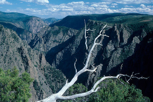
The Black Canyon of the Gunnison National Park ("Black Canyon of the
Gunnison National Park") is a national park of the United States
located in the western part of the state of Colorado. It consists of
a narrow and deep gorge belonging to the Gunnison River, having been
established in 1933 and occupying an area of 83 km2. The park
includes 19 km of 77 km of Gunnison River Canyon. Black canyon takes
its name from its walls stained and full of lichen, which accentuate
the darkness of the abyss. It was previously protected since 1933 as
a Black Canyon of the Gunnison National Monument.
The Black
Canyon is a deep gorge through which the Gunnison River flows. It is
so narrow that very little sunlight falls to the bottom, making the
walls look dark to black, giving the canyon its name. At the Chasm
Overlook lookout point it reaches a depth of 555 meters at only 345
meters between the edges of the gorge. In the Canyon, the Gunnison
River has an average gradient of 18 meters per kilometer. In the
3.2-kilometer section between "Pulpit Rock" and "Chasm View",
however, the gradient is 50 meters per kilometer. From the rim of
the canyon, you can hear the roar of the Gunnison river as it rushes
through the gorge. The river digs in for about three centimeters per
hundred years.
The Black Canyon of the Gunnison Canyon,
visible today, dates back to the last two million years when the
Gunnison River dug through a Jurassic sandstone stratum and hit the
surface of a block of some 2 billion years of Precambrian rock. It
consists of gneiss pegmatite passages showing a pronounced planar
directional structure (foliation). The resistance of the rock, which
is under tremendous pressure over geologically long periods of time,
explains the almost exclusively vertical erosion.
1. Drive the South Rim Road (Most Popular Option)
This scenic
drive has 12 overlooks with easy-to-moderate access. Key stops include:
Gunnison Point — Often called one of the best overall views; great
starting point near the visitor center.
Pulpit Rock Overlook — Wide
views of the river and contrasting canyon sides.
Chasm View & Painted
Wall View — Highlights the narrowest section and the famous Painted Wall
(Colorado’s tallest cliff at ~2,250 ft with dramatic light/dark
streaks).
Cedar Point and Dragon Point — Excellent for sunsets with
panoramic river views.
Allow 2–3 hours to stop at multiple
points. Many overlooks have short paved or easy paths.
2. Must-Do
Short Hikes (South Rim)
Warner Point Nature Trail (1.5 miles RT,
moderate, ~420 ft gain) — One of the best hikes for sweeping canyon +
mountain views at the end of South Rim Road.
Oak Flat Loop Trail (1–2
miles RT, moderate-strenuous) — Descends below the rim with steep
sections and great river/canyon wall views. Not ideal for heights or
small kids.
Rim Rock Nature Trail (1 mile) — Flat-ish path along the
rim with excellent sheer-wall vistas.
3. North Rim Highlights
(Quieter & Worth It)
Drive the North Rim Road for fewer crowds:
Chasm View Nature Trail (0.5 miles, easy loop) — Short and rewarding
with views of the canyon’s narrowest point.
North Vista Trail to
Exclamation Point (3 miles RT, moderate) — Often praised as one of the
park’s best viewpoints.
Other stops: Exclamation Point, The Narrows,
Balanced Rock, Island Peaks.
4. Other Experiences
East Portal
Road — Steep drive down to the river level for fishing, picnics, or a
different perspective (narrow road, not for big RVs).
Inner Canyon —
For experienced hikers only (permit required). Routes like Gunnison
Route are very steep and strenuous.
Stargazing — The park is an
International Dark Sky Park—excellent for night skies.
Wildlife
Watching & Rock Climbing — Spot birds, bighorn sheep, etc.; advanced
climbing on the walls.
Practical Tips
Best Time: Summer for
full access; spring/fall for fewer crowds and milder temps. Winters have
limited services but snowshoeing/cross-country skiing opportunities.
Entrance: South Rim Visitor Center is the main hub. America the
Beautiful Pass covers entry.
Safety: Many drop-offs lack
guardrails—watch kids and stay on trails. Trails can be rocky/steep.
Time Needed: 1 full day for South Rim highlights; 2 days to include
North Rim.
Scenic Drives and Overlooks
The main way to experience the park is
by driving the rim roads and stopping at viewpoints (many with short
walks).
South Rim Road (most visited): Stops include Tomichi
Point, Gunnison Point, Pulpit Rock Overlook, Chasm View, Painted Wall
View (tallest cliff in Colorado at 2,250 ft), and others. Many overlooks
are short walks from parking areas.
North Rim Road: More remote;
highlights include Balanced Rock, Narrows View, and Chasm View
(narrowest part of the canyon).
East Portal Road: Steep descent to
the river level (not recommended for large RVs/trailers).
Tip: Drive
both rims if time allows (North Rim is about 1.5–2 hours from the South
Rim via paved roads). Views are especially dramatic at sunrise or
sunset.
Hiking
Trails range from easy rim walks to strenuous
inner-canyon routes. Many have steep drop-offs—watch children closely.
Popular South Rim hikes:
Warner Point Nature Trail (1.5 miles RT,
moderate, ~420 ft gain): Highly rated for panoramic canyon and river
views. Starts at High Point Overlook.
Oak Flat Loop Trail (1–1.5
miles, moderate-strenuous): Steep with exposure; great views of canyon
walls and river. Not ideal for heights.
Cedar Point Nature Trail or
Rim Rock Trail: Shorter, interpretive options with good views.
Popular North Rim hikes:
North Vista Trail to Exclamation Point (~3
miles RT, moderate): Often called one of the best views in the
park—straight down the canyon.
Chasm View Nature Trail (0.5 miles
loop, easy): Short interpretive trail to the narrowest section.
Inner Canyon routes (advanced only): Steep, unmaintained scrambles like
the Gunnison Route (drops ~1,800 ft in 1 mile), Warner Route, or Tomichi
Route. Require a free wilderness permit, excellent fitness,
route-finding skills, and preparation (poison ivy, loose rock, no marked
trails). Watch a required orientation video.
Other Activities
Rock Climbing: World-class big-wall climbing on sheer cliffs;
experienced climbers only. Check regulations.
Wildlife Watching: Mule
deer, bighorn sheep, birds (including raptors), and more. Be bear
aware—secure food.
Stargazing: International Dark Sky Park—excellent
night skies year-round.
Fishing: Trout fishing in the Gunnison River
(regulations apply).
Camping: South Rim (views, some electric sites)
or North Rim campgrounds. Reservations recommended in peak season.
Ranger Programs: Check for talks or Junior Ranger activities at the
South Rim Visitor Center.
Winter: Limited access but opportunities
for snowshoeing/cross-country skiing on closed roads.
Practical
Tips
Entrance Fee: $30/vehicle (7 days); America the Beautiful Pass
accepted. Cashless in some cases.
Visitor Centers: South Rim (main,
open daily in summer ~8 AM–5/6 PM); North Rim Ranger Station more
limited.
Best Time: Late spring to fall for full access. South Rim
open year-round.
Preparation: High elevation, variable weather, no
water in some areas seasonally. Trails can be rocky/steep—sturdy shoes
recommended. Check current conditions on nps.gov/blca.
By Car (Most Common Option)
There is no public transportation
inside the park, so a personal vehicle is the primary way to explore it.
South Rim (Main Entrance & Visitor Center)
From Montrose, CO
(closest town, ~14 miles / 20–30 minutes): Drive east on US Highway 50
for about 6–7 miles, then turn north (left) onto CO Highway 347. Follow
it for ~7 miles to the entrance.
GPS/Physical Address: 9800 Hwy 347,
Montrose, CO.
The South Rim Road is paved and open year-round
(weather permitting).
North Rim
From Crawford, CO (~11 miles):
From CO Highway 92, turn west onto Black Canyon Road about 3 miles south
of Crawford. Follow signs to the park.
GPS/Physical Address: 7295
Black Canyon Road, Crawford, CO.
The last ~7 miles are unpaved
(manageable for most vehicles but can be rough). The North Rim is closed
to vehicles in winter.
Note: There is no bridge across the
canyon. Driving between the South and North Rims takes 2–3 hours via
non-park roads.
Nearest Airports
Montrose Regional Airport
(MTJ): Closest (~15–20 minutes to South Rim). Served by major airlines
like United, American, Delta, and Allegiant.
Grand Junction Regional
Airport (GJT): ~1–1.5 hours drive (~75 miles from South Rim). More
flight options.
Denver International Airport (DEN): ~4–5 hours drive
(264 miles from South Rim). Best for broader connections.
Rent a car
at the airport for the drive into the park.
Driving Distances to
South Rim (approx.)
Montrose: 14 miles
Grand Junction: 75 miles
Gunnison: 63 miles
Denver: 264 miles
Ouray: ~36 miles (via
Montrose)
Tips for Your Visit
The park is open 24/7, but the
South Rim Visitor Center has seasonal hours (typically 8 AM–6 PM in
summer).
Check the official NPS site (nps.gov/blca) for current road
conditions, fees, and alerts—mapping apps may have issues with seasonal
closures.
Summer is busiest; spring/fall offer fewer crowds and great
views. Winters can bring snow/ice on roads.
The entrance fee for a single visit to Black
Canyon of the Gunnison National Park is $15. It covers all persons
in a single, private, non-commercial vehicle and is valid for seven
calendar days. The entry fee for pedestrians, bicyclists,
motorcycles, motor scooters, or mopeds is $7 per person. There is no
fee charged for persons 16 years of age or younger. You can also buy
a Black Canyon Annual Pass for $30, which is valid for 12 months.
Also, a free permit is required for all backcountry and wilderness
use, both day use and overnight.
There are several passes for
groups traveling together in a private vehicle or individuals on
foot or on bike. These passes provide free entry at national parks
and national wildlife refuges, and also cover standard amenity fees
at national forests and grasslands, and at lands managed by the
Bureau of Land Management and Bureau of Reclamation. These passes
are valid at all national parks including Black Canyon of the
Gunnison National Park:
The $80 Annual Pass (valid for twelve
months from date of issue) can be purchased by anyone. Military
personnel can obtain a free annual pass in person at a federal
recreation site by showing a Common Access Card (CAC) or Military
ID.
U.S. citizens or permanent residents age 62 or over can
obtain a Senior Pass (valid for the life of the holder) in person at
a federal recreation site for $80, or through the mail for $90;
applicants must provide documentation of citizenship and age. This
pass also provides a fifty percent discount on some park amenities.
Seniors can also obtain a $20 annual pass.
U.S. citizens or
permanent residents with permanent disabilities can obtain an Access
Pass (valid for the life of the holder) in person at a federal
recreation site at no charge, or through the mail for $10;
applicants must provide documentation of citizenship and permanent
disability. This pass also provides a fifty percent discount on some
park amenities.
Individuals who have volunteered 250 or more
hours with federal agencies that participate in the Interagency Pass
Program can receive a free Volunteer Pass.
4th graders can
receive an Annual 4th Grade Pass that allows free entry for the
duration of the 4th grade school year (September-August) to the
bearer and any accompanying passengers in a private non-commercial
vehicle. Registration at the Every Kid in a Park website is
required.
In 2018 the National Park Service will offer four days
on which entry is free for all national parks: January 15 (Martin
Luther King Jr. Day), April 21 (1st Day of NPS Week), September 22
(National Public Lands Day), and November 11 (Veterans Day weekend).
Getting There and Park Basics
Location and Access: The park sits
near Montrose, CO. The South Rim (main area) is more accessible via
paved South Rim Road. The North Rim is more remote (about 2+ hours drive
from the South Rim via Hwy 92 and North Rim Road, part gravel). East
Portal Road leads to the river level (steep, narrow; not for large RVs
or trailers).
Park Hours: Open 24/7 year-round. No vehicle
reservations required.
Entrance Fees (as of 2026): $30/vehicle (7
days), $25/motorcycle, $15/person (foot/bike, age 16+). America the
Beautiful Annual Pass covers it. Buy online via Recreation.gov or at the
entrance for faster entry. The park is cashless—use cards or digital
passes. Annual park pass: $55.
Visitor Center: South Rim Visitor
Center offers exhibits, info, water, restrooms, and rangers. Stop here
first for current conditions, maps, and permits.
Check alerts and
conditions on the NPS website before visiting, especially for road/fire
impacts (e.g., 2025 South Rim Fire affected some areas/campgrounds).
Best Time to Visit
Peak Season (Late Spring–Early Fall): South
Rim Road fully open; best for hiking/driving. Summers are hot/dry
(desert-like at rim ~8,000 ft elevation). Fall brings fewer crowds and
aspens changing color.
Shoulder Seasons: Spring/fall milder with
lighter crowds. Winter: South Rim accessible for snowshoeing/skiing
(North Rim road closes to vehicles).
Avoid peak summer afternoons for
heat/exposure.
Driving and Overlooks (Top Activity for Most
Visitors)
South Rim Drive: 7-mile scenic road with 12+ overlooks
(e.g., Tomichi Point, Gunnison Point, Chasm View, Painted Wall—the
tallest cliff in CO at 2,250 ft). Many require short walks; some
paved/accessible. Allow 2–4 hours round-trip with stops.
North Rim:
Quieter, fewer people. Unpaved road sections; 5 overlooks including
Narrows and Chasm View. Great for solitude.
Tips: Use pullouts (no
stopping in road). Blind curves and steep drop-offs (many without
guardrails). Drive slowly, especially East Portal Road (use low gear,
watch brakes/coolant).
Hiking Tips
Rim trails are short and
rewarding; inner canyon is extreme.
Easy/Moderate Rim Trails (South
Rim):
Cedar Point Nature Trail (0.7 mi RT): Views of Painted Wall.
Warner Point Nature Trail (1.5 mi): Panoramic canyon + mountains.
Rim
Rock Nature Trail (1 mi): Connects campground to visitor center.
North Rim: Chasm View Nature Trail (0.3 mi loop) offers dramatic views.
Inner Canyon Routes: These are not maintained trails—unmarked, steep
scrambles with loose rock, exposure, poison ivy, and extreme heat/cold.
Only for experienced, fit hikers with route-finding skills. Permits
required (limited daily slots). South Rim routes often need
Recreation.gov reservations in peak season; North Rim first-come. Bring
4+ quarts water/person/day, map/compass/GPS, WAG bag, layers, headlamp,
and emergency gear. Self-rescue mindset essential.
General Hiking
Advice:
Stay on trails near drop-offs; supervise kids closely.
No
shade; bring sun protection (hat, sunscreen, long sleeves).
Ticks
possible—check after hikes.
Download NPS app for offline maps.
Safety Essentials
Altitude: Rim at ~8,000 ft. Acclimatize,
hydrate, watch for AMS symptoms (headache, nausea).
Heat/Dehydration:
Desert climate—bring plenty of water. No services in canyon.
Cliffs:
No throwing rocks (fatal to those below). Unstable edges.
Weather:
Summer thunderstorms/lightning common—seek shelter in vehicle/building.
Check forecasts.
Wildlife: Bear-aware (food in lockers/vehicles).
View from distance; make noise on trails. Ticks, poison ivy.
Cell
Service: Limited/none. Tell someone your plans; consider satellite
device.
Roads: Steep/narrow—RVs limited on some.
Camping
South Rim Campground: ~88 sites, some electric. Reservations via
Recreation.gov (often fills). Partially reopened post-fire in 2026.
Views, amphitheater programs.
North Rim: 13 primitive sites,
first-come (Scan & Pay app).
East Portal (Curecanti NRA): River
access, 15 sites.
Fees ~$20–$34/night. No showers. Bear lockers
required. Winter: Limited sites, no water.
Wilderness Camping:
Permitted with inner-canyon permit (restrictions apply).
No lodging
inside park—stay in Montrose or Gunnison.
What to Bring and Other
Tips
Essentials: Water (lots), snacks/lunch (no restaurants), sturdy
shoes, sun protection, layers, binoculars, flashlight, first aid, map.
Groceries in Montrose.
Pets: Leashed on some trails/roads; not on
most trails or inner canyon. Check rules.
Accessibility: Some
overlooks/visitor center accessible; check NPS site.
Leave No Trace:
Pack out trash; stay on trails.
Crowds: Less busy than major
parks—start early for heat/parking (though parking usually fine).
Nearby: Combine with Curecanti NRA, Telluride, or Million Dollar
Highway.
Download the free NPS app for maps, alerts, and offline
use. Always verify current conditions on nps.gov/blca.
Black Canyon of the Gunnison National Park is one of Colorado’s most
dramatic and underrated national parks. Its sheer, shadowed
walls—dropping up to 2,700 feet in places—make it one of the steepest,
narrowest, and deepest canyons in North America, carved by the Gunnison
River over two million years through ancient Precambrian rock. While the
South Rim draws most visitors with its paved scenic drive and easy
overlooks, the park rewards those who venture off the beaten path with
true hidden gems: remote trails offering solitude, below-rim
experiences, river-level access, and some of the darkest night skies in
the country.
These lesser-known experiences feel intimate and wild
compared to more crowded parks like Rocky Mountain or Grand Canyon. Many
require minimal extra effort (or a permit and preparation for the
adventurous), but deliver profound rewards—quiet sunsets, direct river
contact, and a sense of wilderness that few visitors encounter. Note
that some South Rim inner-canyon routes were impacted by the 2025 fire,
so always check current NPS alerts.
1. The North Rim: The Park’s
Premier Hidden Gem for Solitude
Most visitors stick to the South Rim,
leaving the North Rim remarkably quiet and primitive. The drive involves
unpaved roads, and facilities are basic (a small ranger station, no
water in some seasons). The payoff? Panoramic views with far fewer
people, often feeling like you have the canyon to yourself.
Deadhorse Trail (North Rim): This 5–6.6-mile moderate loop (or
out-and-back) winds through sagebrush, oak, and piñon-juniper with
gentle elevation gain (~685 feet). It’s peaceful and scenic, offering
views into Deadhorse Gulch and the inner canyon. The real hidden magic
lies in inconspicuous, unnamed viewpoints along the trail—small spurs or
clearings that provide intimate, uncrowded canyon vistas. One standout
(detailed in photography guides) is an exceptional quiet sunset spot
with sweeping west-facing views. It’s ideal for hikers seeking solitude
over the busier South Rim trails.
Exclamation Point via North Vista
Trail: A relatively easy 3-mile round-trip (extendable to ~7 miles to
Green Mountain summit for 360° views). The trail follows the rim through
forest before reaching Exclamation Point, widely regarded as one of the
park’s best viewpoints. You get a dramatic straight-on look down the
canyon’s “Narrows” section, with the river roaring far below and
towering walls framing the scene. It’s less crowded than South Rim
equivalents and feels more immersive.
Chasm View Nature Trail: A
short, easy 0.3–0.5-mile loop right from the North Rim Campground. It
delivers jaw-dropping views straight into the narrowest, deepest part of
the canyon (the Narrows). Railings make it family-friendly, but the
perspective from the opposite side of the South Rim overlooks is unique
and often uncrowded.
Long Draw Trail: A steep 0.6-mile one-way
descent (~1,600 feet) to the river in the Narrows. It’s a shorter, more
accessible way to experience the inner canyon without a full wilderness
commitment (limited exploration at the bottom; no overnight).
2.
South Rim Hidden Treasures: Subtle Below-Rim Feels and Sunset Magic
The South Rim is more developed and visited, but these spots offer
unique twists.
Oak Flat Loop Trail: A 1.4-mile moderate loop through
Gambel oak forest that dips below the rim slightly (~300 feet elevation
change). It’s one of the few “longer” rim trails and feels more
immersive than pure overlook stops. The standout hidden feature? A
beautiful, accessible climbing wall about 0.6 miles in—the trail
actually passes directly above and below beginner-to-intermediate
routes. It’s a rare, low-commitment taste of the canyon’s vertical world
without needing big-wall gear or permits.
Dragon Point and Cedar
Point Overlooks: These west-facing South Rim viewpoints are fantastic
for sunsets, with the river winding far below and golden light
illuminating the cliffs. Dragon Point sits above the Warner Route; Cedar
Point offers similar drama. They’re less hyped than Painted Wall but
deliver stunning, uncrowded golden-hour magic.
3. East Portal
Road: The Only Easy Drive to the River Bottom
This is a true hidden
adventure most visitors skip. From the South Rim entrance, turn onto the
East Portal Road (managed partly by the Bureau of Reclamation;
within/adjacent to Curecanti NRA). It’s the steepest paved road in
Colorado (up to 16% grades, narrow and winding—vehicles over 22 feet
prohibited). The 5–7 mile descent drops ~2,000 feet to the Gunnison
River level.
At the bottom: a short ~0.8-mile round-trip primitive
trail along the river, picnic areas, a campground, and direct water
access. It’s the only car-accessible spot at river level in the canyon.
Historical interpretive signs tell the story of the Gunnison Tunnel and
early 20th-century workers. Fishing, picnicking, and a sense of being
deep in the gorge make it special. The road closes in winter.
4.
Inner Canyon Wilderness Routes: Raw River Adventures (Advanced Only)
For the ultimate hidden experience, descend via unmarked wilderness
routes to the river. These are strenuous, route-finding scrambles on
loose rock, steep slopes, and brush (Class 3 moves possible; poison ivy
common). They require wilderness permits and self-sufficiency.
Black Canyon of the Gunnison National Park, located in
western Colorado, preserves one of North America’s most dramatic
canyons: a 48-mile-long gorge carved by the Gunnison River, with only
about 14 miles (the deepest and narrowest section) protected within the
park’s roughly 30,750 acres. Its sheer walls, up to 2,722 feet deep at
Warner Point and narrowing to just 40 feet at the river in places, drop
an average of 43 feet per mile (and up to 240 feet per mile at Chasm
View), creating some of the steepest cliffs in North America. The
canyon’s “black” appearance comes from its shadowed depths and dark
metamorphic rock.
The park’s history spans nearly two billion years
of geology and about 9,000 years of limited human use. Its rugged nature
has always limited human influence—only the rims (never the inner gorge)
show evidence of occupation—making it a place where natural forces
dominate.
Geological History: Formation of a Dramatic Gorge
The canyon’s story begins in the Precambrian era, about 1.8–1.7 billion
years ago, when ancient volcanic island arcs collided with the southern
edge of what is now Wyoming. This mountain-building event subjected
thick sequences of sandstones, shales, and volcanic rocks to intense
heat, pressure, folding, and metamorphism, transforming them into the
dark gneiss and schist that form the canyon’s steep walls today.
Lighter-colored pegmatite dikes intruded later, crosscutting the
basement rocks.
Around 60 million years ago, during the Laramide
orogeny (part of the Gunnison Uplift), the region rose again, elevating
these ancient rocks to high elevations. About 30 million years ago,
massive volcanic eruptions on either side of the uplift (from areas now
including the West Elk, La Sal, Henry, and Abajo mountains) buried the
older rocks under thousands of feet of volcanic ash, debris, and
sedimentary layers.
By about 15 million years ago, the modern
Gunnison River had established its course as runoff from nearby ranges
began eroding the softer volcanic and sedimentary cover. A broad uplift
2–3 million years ago (Quaternary period) trapped the river in its path.
Unable to shift course, the Gunnison—then much larger and more powerful,
especially during floods with high turbidity—began scouring the
extremely hard Precambrian metamorphic rocks. It eroded downward at an
average rate of about 1 inch per 100 years, while side streams and
weathering created the sheer, vertical walls.
The result is one of
the world’s best exposures of Precambrian “basement rocks,” alongside
younger igneous, metamorphic, and sedimentary layers. The canyon also
contains paleontological resources like Jurassic and Cretaceous fossil
plants, invertebrates, fragmentary vertebrates, and trace fossils. Its
position on the edge of the Colorado Plateau and Southern Rocky
Mountains underscores this complex history of deposition, uplift,
volcanism, and relentless river erosion.
Indigenous and
Prehistoric Presence
Archaeological evidence shows humans have used
the canyon rims for at least 9,000 years, though the inner gorge’s
inaccessibility and danger meant it was never occupied or routinely
traversed. Sites are limited to the rims and reflect seasonal or
transient activity rather than permanent settlement.
The area was
long known to the Ute people, particularly the Tabeguache (or
Uncompahgre) band—“People of the Sun Mountain”—the largest of the ten
nomadic Ute bands in the Northern Ute group. They traveled seasonally
through the river valleys of the Gunnison and Uncompahgre rivers for
hunting, gathering, and other resources. Ute tradition sometimes
referred to the river as “much rocks, big water,” and many avoided the
deep canyon out of superstition or respect for its formidable nature.
Five federally recognized tribes and one tribal community maintain
cultural ties to the area today: the Ute Indian Tribe of the Uintah and
Ouray Reservation, Ute Mountain Ute Tribe, Southern Ute Indian Tribe,
White Mesa Ute Community, Jemez Pueblo, and Absentee-Shawnee Tribe of
Indians of Oklahoma. These connections reflect long-standing stewardship
of the broader landscape.
European Exploration and the First
Written Accounts
No early Spanish explorers explicitly documented the
canyon’s depths, though expeditions passed nearby. In 1765, Juan
Rivera’s party sought a route to California. Fathers Dominguez and
Escalante’s 1776 expedition also skirted the region while searching for
a passage west.
Fur trappers in the early 1800s knew of the canyon
while hunting beaver but left no written records. The first official
written description came from the 1853 expedition led by Captain John
Williams Gunnison, part of the U.S. Pacific Railroad Surveys. Gunnison’s
party, seeking a transcontinental railroad route from St. Louis to San
Francisco, reached the canyon near present-day Lake Fork on September 7,
1853. They described the area as “the roughest, most hilly and most cut
up” terrain and noted the river (then called the Grand) embedded in a
“narrow and sinuous canyon, resembling a huge snake in motion.” Gunnison
deemed a railroad through it impractical due to engineering challenges.
The expedition continued into Utah, where Gunnison and several men were
killed later that year in a Paiute attack. His second-in-command, Lt.
E.G. Beckwith, completed the report. The river was later renamed the
Gunnison in his honor, and the nearby town also bears his name.
Subsequent 1850s railroad surveys avoided the canyon.
Railroad,
Irrigation, and Early 20th-Century Development
In 1881–1882, the
Denver & Rio Grande Railroad (under William Jackson Palmer) built a
narrow-gauge line from Gunnison through the upper Black Canyon (Sapinero
to Cimarron) to link to San Juan mining districts. Irish and Italian
laborers carved a 15-mile roadbed at enormous cost—up to $165,000 per
mile in places, with the last mile exceeding the entire Royal Gorge
project. The first passenger train ran on August 13, 1882. Observers,
including the editor of the Gunnison Review-Press, marveled at the
“largest and most rugged canyon in the world” traversed by rail,
describing its “grandeur and magnificence.” Rudyard Kipling later called
a ride through it “a glory and a wonder and a mystery.”
The line
later lost importance for through traffic after an alternate route
opened, but local service continued until abandonment in the early
1950s. Remnants, including a steel bridge, are preserved near Cimarron.
Water development followed. The Uncompahgre Valley faced shortages from
settler influx. In 1900, an initial boat expedition failed. In August
1901, USGS hydrographer Abraham Lincoln Fellows and local mountaineer
William Torrence made the first recorded full descent of roughly 30
miles of the canyon bottom. Starting near Cimarron with a custom rubber
raft, 35-pound packs, ropes, and knives, they endured 10 days of
climbing rockfalls, swimming over 70 river sections, and navigating
narrows and rapids. They emerged with data proving a diversion tunnel
feasible.
Construction of the 5.8-mile Gunnison Tunnel (East Portal
area) began in 1905 by the U.S. Reclamation Service. Conditions were
brutal—high carbon dioxide, heat, humidity, water, mud, and fractured
rock—leading to delays and about 26 deaths. Dedicated in 1909 by
President William Howard Taft, it remains in use today, delivering
irrigation water to the Uncompahgre Valley.
Path to National Park
Status and Modern Development
Local citizens in the early 20th
century lobbied for conservation and recreation, recognizing the
canyon’s scenic value beyond resource extraction. On March 2, 1933,
President Herbert Hoover proclaimed Black Canyon of the Gunnison a
national monument.
The Civilian Conservation Corps (CCC) worked from
1933–1935, building the North Rim Road (a historic district on the
National Register), South Rim infrastructure, trails, campgrounds,
overlooks, and NPS buildings despite the site’s remoteness and small
initial size. Later Mission 66 projects (1950s–1966) upgraded roads,
paved the scenic drive, added self-guided trails, and improved visitor
facilities. In 1976, about half the monument (15,599 acres) became
wilderness.
On October 21, 1999, President Bill Clinton signed
legislation redesignating it Black Canyon of the Gunnison National Park
and adding about 4,000 acres of Bureau of Land Management land. The
nearby Gunnison Gorge National Conservation Area was also established.
In 2017, the 2,500-acre Sanburg Ranch was added.
Today, the park
emphasizes preservation of its geologic wonder, limited cultural
resources on the rims, and wilderness character. The inner canyon
remains largely untouched—a challenge for expert boaters, climbers, and
hikers—while rims offer accessible views and trails. Visitor numbers
reflect its growing popularity as a destination for scenery, recreation,
and quiet reflection on deep time and human resilience against nature’s
barriers.
Location and Physical Setting
The park lies in
Montrose County, about 15 miles east of the town of Montrose via U.S.
Highway 50 and Colorado Highway 347 (South Rim entrance). The North Rim
entrance is roughly 11 miles south of Crawford and is closed in winter.
It sits in a transitional zone on the far eastern edge of the Colorado
Plateaus physiographic province, immediately adjacent to the Southern
Rocky Mountains to the east. This position gives the canyon a unique
blend of plateau-like mesas and rimrock with mountain influences.
The
park encompasses approximately 30,750 acres (124.4 km²) and includes
about 12–14 miles of the Gunnison River’s course—the most dramatic
stretch. The full Black Canyon extends 48 miles (77 km) total,
continuing upstream into Curecanti National Recreation Area and
downstream into Gunnison Gorge National Conservation Area. Rim
elevations range from roughly 7,000–8,800 feet (2,100–2,700 m), with the
river at lower elevations around 5,400 feet (1,650 m) in the park.
Canyon Dimensions and Topography
The Black Canyon is renowned for
being deeper than it is wide in many places, creating a narrow,
slot-like gorge that feels intimate yet overwhelming.
Depth:
Average about 2,000 feet (610 m); maximum 2,722 feet (829 m) just north
of Warner Point (the deepest point anywhere in the canyon).
Width: At
the river, the narrowest point is just 40 feet (12 m) at The Narrows.
Rim-to-rim width narrows to about 1,100 feet (335 m) at Chasm View.
Steepness and Gradient: The Gunnison River drops an average of 34–43
feet per mile (6.4–8 m/km) through the canyon—making it the 5th steepest
mountain descent in North America. At Chasm View, the drop reaches 240
feet per mile (45 m/km). By comparison, the Colorado River through the
Grand Canyon drops only about 7.5 feet per mile.
These
proportions create nearly vertical walls that block sunlight for much of
the day—some sections receive as little as 33 minutes of direct sun
daily—giving the canyon its dark, shadowy appearance and name. The walls
are often lichen-covered or appear blackish due to the somber
Precambrian rock and deep shadows.
Hydrology: The Gunnison River
The Gunnison River is the primary force shaping the canyon. It flows
swiftly and turbulently through the gorge with high erosive power from
its steep gradient, historical high flows, and sediment load (including
boulders acting like “wrecking balls” during floods). The river’s course
is largely superimposed: it established itself on softer overlying
volcanic and sedimentary layers millions of years ago and then incised
downward as regional uplift continued, unable to shift laterally once
trapped in the hard bedrock.
Feeder canyons entering the main gorge
sometimes slope in the “wrong” direction (opposite modern drainage),
evidence of major shifts in regional drainage patterns during uplift.
Geology and Formation History
The canyon’s story spans nearly two
billion years and reveals deep Earth processes.
Precambrian Basement
Rocks (≈1.7–1.8 billion years old): The dominant walls consist of dark,
foliated metamorphic rocks—primarily gneiss and schist—formed during
ancient volcanic island-arc collisions with the southern edge of what is
now Wyoming. These are among the oldest exposed rocks in North America
and provide a rare window into extreme heat, pressure, and continental
assembly. Lighter-colored pegmatite dikes (pinkish-white granite-like
intrusions with crystals up to 6 feet long) cross-cut the darker rock
dramatically.
Key Events:
≈60 million years ago (Laramide
Orogeny): The Gunnison Uplift raised these ancient rocks.
≈30 million
years ago: Widespread volcanism from nearby ranges (West Elk, La Sal,
etc.) buried the uplift under thousands of feet of softer volcanic ash
and debris.
≈15–2 million years ago: The Gunnison River began carving
through the soft cover.
≈2 million years ago onward (Quaternary
uplift): The river reached the hard Precambrian basement and eroded
vertically at roughly 1 inch (2.5 cm) per 100 years, producing the sheer
walls because the rock resists lateral erosion.
The result is a
canyon that combines depth, narrowness, and near-verticality in a way
few others do.
Iconic Features
Painted Wall: Colorado’s
tallest sheer cliff at approximately 2,250 feet (686 m). It is
dramatically striped with light pegmatite dikes against the dark gneiss,
resembling abstract art.
The Narrows: The canyon’s tightest point.
Chasm View and Warner Point: Offer breathtaking overlooks of maximum
depth and gradient.
Pinnacles, buttresses, and rock pillars:
Weathered into the resistant metamorphic rock along the rims and walls.
Broader Geographical Context
The park’s rims feature
pinyon-juniper woodlands, sagebrush, and mountain mahogany typical of
the transition between plateaus and mountains. Overlying sedimentary
layers (Mesozoic) and volcanic caps appear on the rims in places,
creating colorful contrasts with the dark inner gorge. The surrounding
landscape includes mesas, hogbacks, and rimrock shaped by the same
uplift and erosion processes.
Climate (warm-summer humid continental)
features cold winters (record low −24°F), warm summers (record high
97°F), and about 20 inches of annual precipitation, much as snow—factors
that influence ongoing erosion through freeze-thaw and seasonal runoff.
Black Canyon of the Gunnison National Park (BLCA) in western Colorado
boasts an exceptionally diverse flora, with more than 650 species of
vascular plants. This diversity arises from the park’s dramatic
topography, which creates sharp microclimate gradients in a relatively
small area (about 12,500 acres). The park sits at the convergence of
ecoregions—primarily the Semiarid Benchlands and Canyonlands of the
Colorado Plateau to the west, with influences from the Southern Rockies
to the east—supporting a mix of montane, temperate, and semi-desert
vegetation.
Elevation ranges from roughly 5,000–8,800 feet along the
rims and inner canyon, with the Gunnison River at the bottom. Key
drivers of plant distribution include aspect (north- vs. south-facing
slopes), soil type, geology (Precambrian gneiss and schist with
pegmatite dikes), sunlight exposure, water availability (from seeps,
springs, and the river), and fire history. Forests and shrublands
dominate, with patches of grassland and rock outcrops. Unique habitats
include riparian zones at the canyon bottom, hanging gardens on seepy
cliff faces, and old-growth pinyon-juniper groves.
Major
Vegetation Communities
Canyon rims and uplands (foothills life zone,
~6,000–8,000 ft): Predominantly pinyon-juniper woodlands and Gambel oak
shrublands. The most widespread mapped vegetation class is Gambel Oak /
Mixed Montane Shrubland (covering ~29% of the area in broader mapping).
Two sizable old-growth pinyon-juniper groves (one on each rim, around
8,000 ft) feature ancient two-needle pinyon pines (Pinus edulis) over
700 years old. Sagebrush shrublands (Artemisia tridentata subspecies)
and rabbitbrush are intermixed.
North-facing slopes: More mesic
(moist) conditions support denser coniferous forests with Douglas-fir
(Pseudotsuga menziesii) and Colorado blue spruce (Picea pungens).
Quaking aspen (Populus tremuloides) groves occur in some protected
areas.
Inner canyon walls and ledges: Steep, rocky, and often shaded
or seepy. These support sparse vegetation, specialized cliff-dwellers,
and hanging gardens (lush pockets of ferns, monkeyflowers, and other
moisture-loving plants fed by seeps).
Canyon bottom / riparian zone:
Narrow floodplain along the Gunnison River features scattered trees and
shrubs adapted to periodic flooding and higher moisture. Includes
deciduous species and some conifers.
The park spans mostly
foothills and montane life zones (with some subalpine influence at
higher points). White-flowered species are most common overall, but
yellow, blue/purple, and other colors appear; flower color can vary by
soil pH, season, or genetics to attract pollinators.
Trees and
Shrubs
Trees and shrubs make up only ~14% of plant species but
dominate the visual landscape.
Coniferous trees (pines, spruces,
firs, junipers):
Two-needle pinyon (Pinus edulis) and Utah juniper
(Juniperus osteosperma) — dominant on rims; old-growth stands.
Ponderosa pine (Pinus ponderosa ssp. scopulorum) — scattered at canyon
bottom.
Douglas-fir and Colorado blue spruce — north-facing slopes.
Others occasionally present in riparian or higher areas.
Deciduous trees (mostly riparian or protected sites; colorful autumn
foliage):
Narrow-leaved cottonwood (Populus angustifolia)
Rio
Grande cottonwood (Populus deltoides ssp. wislizenii)
Quaking aspen
(Populus tremuloides)
Rocky Mountain maple / box elder (Acer negundo
/ Negundo aceroides ssp. interius)
Singleleaf ash (Fraxinus anomala)
Coyote willow (Salix exigua)
Dominant shrubs (thickets provide
wildlife cover and food):
Gambel oak (Quercus gambelii) — forms
dense, brushy thickets via underground lignotubers; widespread and
ecologically key.
Serviceberry (Amelanchier spp., e.g., A. alnifolia)
Mountain mahogany (Cercocarpus montanus)
Big sagebrush (Artemisia
tridentata subspecies)
Rabbitbrush, snakeweed, and Fendler’s bush
(Fendlera spp.)
Fremont’s mahonia (Mahonia fremontii)
Wildflowers and Flowering Plants
Hundreds of herbaceous species bloom
across seasons:
Early season (April–June): Many on rims and uplands.
Mid-season (June–July).
Late season (July–September).
Examples
observed in the park include Wyoming paintbrush (Castilleja
linariifolia), Rocky Mountain penstemon (Penstemon strictus), showy
milkweed (Asclepias speciosa), cutleaf coneflower (Rudbeckia ampla),
arrowleaf balsamroot (Balsamorhiza sagittata), and lance-leaved
stonecrop (Sedum lanceolatum). Wildflowers thrive on canyon rims,
uplands, inner canyon cracks, and beneath forest canopies.
Cacti
and Desert Succulents
Six cactus species (all low-growing,
cold-tolerant) grow mainly on canyon rims in rocky outcrops among
pinyon-juniper and desert shrubs. Most bloom April–May; claretcup in
mid-summer.
Claretcup cactus (Echinocereus triglochidiatus)
Brittle pricklypear (Opuntia fragilis)
Berry pricklypear (Opuntia
phaeacantha)
Plains pricklypear (Opuntia polyacantha)
Mountain
ball cactus (Pediocactus simpsonii)
Pincushion cactus (Coryphantha
vivipara)
The only confirmed non-cactus succulent is Harriman’s
yucca (Yucca harrimaniae), with yellowish-white flowers on a central
stalk in early spring. Succulents store water in fleshy tissues and have
adaptations like spines for defense and reduced transpiration.
Rare and Unique Plants
The canyon’s extreme verticality and
microhabitats support endemics and specialists:
Black Canyon gilia
(Gilia or Aliciella penstemonoides) — Colorado endemic; grows in tiny
crevices on vertical rock faces (often requiring ropes or scopes to
survey).
Hanging garden sullivantia (Sullivantia hapemanii var.
purpusii) — thrives in moist, shaded seepy cliff ledges and hanging
gardens alongside ferns (e.g., maidenhair) and other moisture-dependent
species.
Gunnison milkvetch (Astragalus anisus)
Juniper
tumble-mustard (Thelypodiopsis juniperorum) — rare endemic.
These are
restricted to small, specialized habitats and are monitored for
long-term trends.
Additional Notes
Invasive exotic plants
(e.g., cheatgrass, Canada thistle, musk thistle, common mullein, Russian
thistle, saltcedar/tamarisk, and others) threaten native communities in
some areas, especially riparian zones and disturbed sites; park staff
prioritize control.
Monitoring shows stable pinyon-juniper but some
declines in native grasses in sagebrush areas and aspen health issues.
Fire, grazing history, and climate influence dynamics.
For the most
complete species list, the NPSpecies database (irma.nps.gov/NPSpecies)
catalogs vascular plants with details on abundance, nativeness, and
occurrence. A 2010–2011 vegetation classification and mapping project
provides detailed maps of 24 classes.
Black Canyon of the Gunnison National Park in western Colorado
supports a rich and diverse fauna, shaped by its dramatic vertical
landscape. The park spans habitats from the canyon rims (with
pinyon-juniper woodlands, Gambel oak, sagebrush, and meadows) down steep
cliffs to the Gunnison River at the bottom. This creates a spectrum of
microenvironments requiring specialized adaptations for survival, from
arid rocky slopes to riparian zones.
Official National Park Service
(NPS) records document 59 mammal species, 174 bird species, 11 reptile
species, 1 amphibian species, and primarily non-native fish in the river
(no native fish currently persist in the park section).
The canyon's
extreme topography—depths over 2,000 feet with sheer walls—limits some
species but fosters specialists like cliff-nesting raptors and agile
ungulates. Many animals are most active at dawn/dusk or seasonally, with
winter bringing hibernation or reduced activity for cold-blooded
species. Below is an in-depth breakdown by major groups, drawing from
NPS documentation on habitats, behaviors, and notable species.
Mammals (59 species documented)
Rodents, rabbits, deer, and bears are
frequently spotted along roadsides and trails. Rarer sightings include
bighorn sheep, elk, river otters, and wild cats. Habitats range from rim
forests/meadows (common for deer and squirrels) to inner canyon cliffs
(bighorn) and the river corridor (otters).
Key groups and
examples include:
Large herbivores and ungulates — Mule deer
(Odocoileus hemionus) are common in brushy areas, open deserts, and
mountains; they browse shrubs, woody plants, and grasses, active at
dawn/dusk (watch for fawns in late spring/early summer). Elk (Cervus
canadensis, or wapiti) appear occasionally (especially North Rim), as
Colorado’s largest native deer; bulls (up to 900 lbs) bugle during the
fall rut. Rocky Mountain bighorn sheep (Ovis canadensis) are iconic but
rare, preferring inaccessible inner-canyon cliffs with grasses and
shrubs; their specialized hooves grip rock, and rams sport massive
curling horns.
Carnivores and predators — Black bears (Ursus
americanus) roam trails/roads (various colors, 100–400 lbs as adults);
they forage seasonally on grasses, berries, insects, and carrion—never
feed them to avoid habituation. Mountain lions (Puma concolor) and
bobcats (Lynx rufus) are stealthy and seldom seen; lions (up to 200 lbs)
hunt deer/elk over large territories, while bobcats (15–35 lbs) target
rabbits and rodents in canyons/mesas. Coyotes, badgers (Taxidea
taxus—nocturnal grassland diggers with fierce predatory bursts),
long-tailed weasels (Mustela frenata—color-changing for winter
camouflage, high-metabolism hunters), and ringtail cats also occur.
River otters (Lontra canadensis) signal improving river health; they are
strong swimmers along the Gunnison.
Small mammals and rodents —
Golden-mantled ground squirrels, rock squirrels, chipmunks,
yellow-bellied marmots, and mountain cottontails (Sylvilagus
nuttallii—most common rabbit, gray with white belly) are widespread and
often visible. They burrow, forage on seeds/nuts/insects, and serve as
prey. Bats (8 species noted in secondary sources) roost in forests/caves
and hunt insects nocturnally.
Many mammals are year-round
residents; some (like bears) enter torpor in winter. Keep food secured
and maintain distance—especially 150+ feet from large species during rut
or with young.
Birds (174 confirmed species)
Birds occupy
every level from rim woodlands to river. Most are permanent or summer
residents; few are winter-only. Canyons are no barrier—they move freely
for food/water. Spring/early summer offers peak diversity and songs.
Notable residents and adaptations include:
Canyon and river
specialists — American dipper (Cinclus mexicanus) dives/walks underwater
(using wings as fins, dense down for insulation) to eat aquatic
insects/larvae along the fast Gunnison River, nesting behind waterfalls.
Canyon wren (Catherpes mexicanus) has a haunting song and forages
spiders/insects in rock alcoves/ledges. White-throated swift (Aeronautes
saxatalis) feeds aerially on insects (early morning/evening) and nests
in high crevices.
Raptors and large birds — Peregrine falcon (Falco
peregrinus) nests on ledges (closures March 15–July 15 for protection);
it dives at 200 mph to strike birds with powerful talons. Also present:
Cooper’s hawk, red-tailed hawk, golden eagle, turkey vulture, and great
horned owl (nocturnal hunter with silent flight and camouflage). Dusky
(blue) grouse forage on the ground in sagebrush (summer) or conifers
(winter).
Songbirds and woodland species — Steller’s jay (loud,
crest-wearing omnivore that mimics sounds), mountain bluebird (bright
males, insectivores nesting in cavities), western tanager (colorful
summer migrant eating insects/fruit), plumbeous vireo, and spotted
towhee (ground-forager with camouflage).
Raptors soar on thermals
and updrafts along rims/cliffs. Checklists are available at the South
Rim Visitor Center or via NPSpecies.
Reptiles and Amphibians (11
reptiles, 1 amphibian)
All are ectothermic (cold-blooded) and
hibernate or inactive in winter. Only snakes and lizards occur—no
turtles or other reptiles. They bask on rocks or hide in crevices; all
snakes here are non-venomous.
Snakes (5 species): Milksnake
(Lampropeltis triangulum), striped whipsnake (Masticophis taeniatus),
smooth greensnake (Opheodrys vernalis), terrestrial gartersnake
(Thamnophis elegans), and gopher snake (Pituophis catenifer). They are
solitary predators that swallow prey whole.
Lizards (6 species):
Eastern collared lizard (Crotaphytus collaris), common sagebrush lizard
(Sceloporus graciosus), plateau lizard (Sceloporus tristichus), tree
lizard (Urosaurus ornatus), greater short-horned lizard (Phrynosoma
hernandesi), and plateau striped whiptail (Aspidoscelis velox). They
perform push-ups for territory/mating and eat insects/spiders/small
prey.
Amphibian: Tiger salamander (Ambystoma tigrinum)—one of North
America’s largest terrestrial salamanders (black/yellow or mottled
patterns). It has an aquatic larval stage, breeds in water, and adults
hide in rodent burrows on land; predators include snakes, bobcats, and
owls.
Fish
No native fish remain in the park’s Gunnison River
section due to dams (built 1961–1978) that altered temperature, flows,
and introduced competitors. The river now supports non-native “trophy”
trout: rainbow trout (Oncorhynchus mykiss—stocked since the 1880s, light
body with black spots and red side stripe) and brown trout (Salmo
trutta—spotted black/red-orange, harder to catch outside fall spawning).
It is designated Gold Medal Wild Trout Water for fishing. River otters
and American dippers benefit from the aquatic insect base.
Wildlife Watching and Safety
Excellent opportunities exist—use
binoculars, stay quiet, blend in, and avoid feeding/disturbing animals.
Common sightings (per NPS): mule deer, squirrels, cottontails, bighorn
sheep (cliffs), canyon wren, peregrine falcon, and various
snakes/lizards.
Safety tips:
Black bears → Back away slowly,
no eye contact, do not run.
Mountain lions → Do not run; appear
large, back away; fight back if attacked.
Drive slowly (especially
for deer/fawns); give large mammals space (150+ ft during rut).