Location: Albany County, WY Map
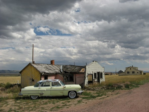
Bosler, Wyoming, is a fading relic of the American West, perched on the vast, windswept plains of Albany County. Often described as a "modern ghost town," it embodies the quiet decay of small frontier settlements that once thrived on railroads and highways but were left behind by progress. Located approximately 19 miles north of Laramie—the county seat—along the concurrent U.S. Routes 30 and 287 (which trace the historic Lincoln Highway), Bosler sits at an elevation of 7,080 feet (2,160 meters) beside the meandering Laramie River. This unincorporated community, with coordinates 41°34′34″N 105°41′43″W, is a stark contrast to the bustling energy of nearby Interstate 80, which bypassed it decades ago, sealing its fate as a shadow of its former self. Today, with only about 15 residents clinging to life amid the ruins, Bosler offers a haunting snapshot of rural America's boom-and-bust cycles, preserved by the arid, high-desert climate that slows the ravages of time.
The town takes its name from the prominent Bosler family,
Pennsylvania-based cattle barons who built a significant ranching empire
in southeast Wyoming starting in the 1860s. James Williamson Bosler
(1833–1883) was the pioneer; he arrived in the West as an army beef
contractor, supplying military posts and Indian agencies in Wyoming,
Colorado, and beyond. He and his family (including brother John Herman
Bosler) invested heavily in cattle operations across Wyoming, Nebraska,
Iowa, New Mexico, and the Dakotas, accumulating vast land holdings.
His heir, Frank C. Bosler (1870–1918), expanded the empire into a “minor
business empire” akin to a regional Rockefeller. Frank partnered with
colorful cowboy John C. Coble in operations like the Iron Mountain Ranch
Company and the Diamond Cattle Company (also called Diamond Ranch), one
of Albany County’s major early ranches. The partnership later dissolved
amid acrimony: Coble (a hot-tempered operator and owner of the famous
bucking bronco “Steamboat”) allegedly misused funds defending the
notorious livestock detective Tom Horn (who used the Iron Mountain Ranch
as a base while working for area ranchers against rustlers). Bosler sued
Coble over the expenses, leading to a notable civil case that reached
the Wyoming Supreme Court; Coble ultimately won damages. Frank Bosler
was known as meticulous and data-driven—sometimes to the point of
frugality—managing large contracts while scrutinizing even minor
discrepancies (e.g., $1.72). The family’s ranches and businesses in the
Bosler area provided the economic foundation for the future town.
Founding as a Railroad Shipping Point (Late 1800s–1909)
The area
had earlier railroad activity. Nearby Wyoming Station (also called Oasis
at one point) on the Union Pacific Railroad served as a cattle-shipping
point and tie-loading site in the late 19th century, with some
settlement and businesses. The Bosler family ranches shipped cattle by
rail from the vicinity.
The modern town of Bosler emerged in the
early 20th century as a planned cattle and railroad shipping center tied
to the family ranches. It was platted in 1909. A land promotion and
irrigation venture by the Tallmadge & Buntin Land Company of Chicago
played a key role: in 1908 they acquired tens of thousands of acres
(including parts of the old Bosler Ranch lands) under the Carey Act,
hyping the area for irrigated agriculture and homesteading with
promotional excursions from Chicago. They sold town lots and promoted
exaggerated agricultural potential (e.g., high-altitude farming claims
that largely failed due to the arid high-plains climate and irrigation
challenges). The original townsite was mostly west of the railroad
tracks (and somewhat below the hill); the post office dates to the early
1900s (sources vary between circa 1900 or 1908; it operated until the
mid-1980s). Some accounts note the town was “incorporated” around 1911,
though it is now unincorporated.
Growth as a Railroad and Lincoln
Highway Town (1910s–1940s)
Bosler’s early economy centered on cattle
shipping for the surrounding ranches. The arrival of the Lincoln Highway
(the first transcontinental auto route, now largely U.S. 30) in
1912–1913 transformed it into a classic “road town.” Initially, the
highway alignment placed most of the townsite west of the tracks;
businesses clustered there. In 1925, the highway was rerouted slightly
east of the railroad, prompting businesses to relocate eastward to the
new alignment. This shift sustained growth for decades as travelers,
ranchers, and rail workers stopped for services.
By the mid-1920s,
Bosler had about 75 residents and a cluster of businesses (general
stores, a newspaper at one point, garage, etc.). It peaked in the
1930s–1940s: the 1940 U.S. Census recorded around 264–300 people.
Amenities included a garage, two motels (one later became Doc’s Western
Village), a handful of stores, a creamery or library building, a
Methodist-Episcopal church, and the Bosler Consolidated School (built
1937). Saturday night dances, church services, and tight-knit community
life were common. The school served local children into the early 1980s
(last class graduated 1983). It also functioned as a minor highway
service stop well into the 1960s.
Decline and Abandonment
(1960s–Present)
The town’s fate was sealed by progress in
transportation. In the 1960s, planning for Interstate 80 (which largely
parallels the old Lincoln Highway but bypasses Bosler to the south)
diverted long-distance traffic. I-80’s completion around 1970–1972
isolated Bosler from the main flow of travelers. Businesses closed
rapidly; the post office shuttered in the mid-1980s. Population
plummeted—from dozens in the 1970s to about 50 by 1990 and far fewer
today. Many buildings stand abandoned or in ruins, giving it a classic
ghost-town atmosphere amid the prairie.
One holdout has been Doc’s
Western Village (a large furniture, antiques, and used-goods store
converted from an old motel), operated by local historian and
photographer Doc Thissen, who has extensively documented the town’s
buildings and stories. A few scattered homes and mobile homes remain
occupied, and the old schoolhouse stands as a prominent landmark. The
community is quiet now, with freight trains still rumbling through and
occasional passersby on the old highway. It has been memorialized in
Jalan Crossland’s song “Bosler,” which evokes nostalgic small-town life.
Bosler’s story is emblematic of many Lincoln Highway-era Wyoming towns:
born of ranching and rail, briefly boosted by early auto tourism, then
left behind by the interstate system. It remains a poignant reminder of
the people who lived, worked, and raised families there before
“progress” passed it by.
Location and Coordinates
Bosler lies approximately 19 miles (about
30 km) north of Laramie (the county seat) along the concurrent U.S.
Routes 30 and 287, which follow the historic Lincoln Highway corridor.
Its precise coordinates are 41°34′34″N 105°41′43″W (or roughly
41.57611°N, 105.69528°W).
It occupies a position in the broader
Laramie Basin, a north-south trending synclinal basin roughly 50 miles
(80 km) long and 31 miles (50 km) wide, bounded by the Laramie Mountains
to the east and the Medicine Bow Mountains to the west.
Elevation
and Topography
The community sits at an elevation of 7,080 feet
(2,160 m) above sea level, typical of the basin floor, which generally
ranges from about 6,900 to 7,500 feet.
The immediate Bosler area (as
shown in USGS 7.5-minute topographic quadrangle maps) features
relatively flat to gently undulating terrain with minor elevation
variations—local relief is low, with elevations ranging roughly from
7,020–7,140 feet (2,140–2,177 m) in the core quadrangle.
The broader
landscape consists of open high plains with rolling hills, broad shallow
valleys, alluvial terraces, and fan aprons along the river. These
features result from Quaternary fluvial and eolian processes, including
Pleistocene periglacial and wind erosion that sculpted the basin floor.
Hydrology
Bosler lies directly along the Laramie River, a key
waterway that flows northward through the Laramie Basin before turning
east across the Laramie Range to join the North Platte River. A USGS
stream gauge (Laramie River near Bosler) monitors flows here, with the
river draining a large upstream area (about 1,500+ square miles
contributing).
The river provides the primary surface water feature,
creating a narrow riparian corridor of cottonwoods, willows, and wetland
vegetation that contrasts sharply with the surrounding arid steppe.
Flows are seasonal—peaking with spring snowmelt (typically June) and
lower in late summer/fall. Historically, the basin’s rivers supported
irrigation attempts, though the arid conditions limited large-scale
success.
Climate
Bosler has a cold semi-arid climate (Köppen
BSk), very similar to nearby Laramie. High elevation and the rain-shadow
effect of surrounding mountains produce:
Low precipitation —
averaging about 10–12 inches (250–300 mm) annually, much of it as snow.
Cold winters — with January lows often in the 10–15°F (−12 to −9°C)
range.
Warm, dry summers — with July highs around 80°F (27°C).
Windy conditions — common year-round due to the open basin topography.
High sunshine — around 230+ sunny days per year.
The short
growing season and temperature extremes shape the local ecology and
limit agriculture to ranching and limited hay production.
Geology
and Soils
The Bosler quadrangle is underlain by Cretaceous
sedimentary rocks (such as shales) on the basin margins, with extensive
Quaternary alluvium, slopewash, and terrace deposits along the river and
fans. The basin itself is a downfolded Laramide structure filled with
older sediments. Local soils (including the Bosler soil series) are
typically deep, well-drained fine-loamy to sandy-skeletal types formed
on relict alluvial surfaces—calcareous and suited to rangeland.
Pleistocene glaciation in the nearby mountains and periglacial/wind
processes left features like playas, terraces, and eroded bedrock
exposures.
Vegetation and Ecology
The dominant landscape is
high-elevation semi-arid shrub steppe and mixed/shortgrass prairie, part
of the Wyoming Basin ecoregion. Common plants include big sagebrush
(Artemisia tridentata), needle-and-thread grass, wheatgrasses, and other
drought-tolerant species.
Land use is primarily rangeland for cattle
and sheep grazing. Riparian zones along the Laramie River support more
mesic vegetation, including trees and shrubs. The open, windswept plains
create a stark, scenic high-plains environment with vast vistas and
minimal tree cover outside drainages.
Bosler's lore is laced with romance and grit. It's immortalized in
the folk song "Bosler" by singer-songwriter Jalan Crossland, which
paints an idyllic picture of trailer-park life, children playing, and
simple joys— a stark, poetic counterpoint to the town's harsh reality.
The ranch's ties to Tom Horn add a layer of Wild West infamy, while the
failed irrigation scheme highlights the perils of overambitious frontier
development. Modern visitors might encounter Doc, who embodies the
resilient spirit of Wyoming's backcountry, trading tales for trinkets.
In popular culture, Bosler has been featured in ghost town guides,
photography exhibits, and even Reddit explorations by adventure riders,
cementing its status as a must-see for history buffs and urban
explorers. As of 2025, it remains a quiet testament to how
infrastructure can make or break a community, with no signs of revival
on the horizon.
Visiting Tips
Best for: History buffs, photographers,
road-trippers seeking offbeat spots. It’s ideal as a quick detour (15–30
minutes) rather than a primary destination.
When to visit: Summer
(June–September) for best weather and road conditions. Winters bring
snow, wind, and potential closures. High plains weather changes
rapidly—check forecasts.
Time of day: Daylight for safe exploration
and photography. Golden hour or stormy skies can make the abandoned
buildings dramatic.
Duration: Most visitors drive through or stop
briefly. Combine with Laramie or other Albany County sites.
Access: Easy drive north from Laramie on US 30/287. Visible from the
highway; some buildings are right along the road. No formal entrance or
fees.
Safety and etiquette:
Respect private property—many
buildings are abandoned but some areas may be occupied or owned.
Watch for uneven ground, debris, animals (snakes, rodents), and
structural hazards in old buildings.
No services in town (gas, food,
water, restrooms). Fuel up and stock supplies in Laramie.
Cell
service may be spotty; download maps offline.
What to See and Do
Drive-through and photography: View clusters of old wooden and brick
buildings, including remnants of motels, homes, and commercial
structures. The decaying school and other relics highlight the town’s
past.
Doc’s Western Village (or Doc’s furniture store): The lone
remaining business, a large furniture outlet/antiques spot in a former
motel building. It may appear closed due to old signage, but it has
operated intermittently. Check current status before expecting it open.
Surrounding scenery: Open high-plains views, railroad tracks, and the
Laramie River area. Opportunities for wildlife spotting (pronghorn,
birds) or quiet reflection.
No formal trails, museums, or events
are centered in Bosler (occasional mentions of things like “Tom Horn
Days” appear outdated or minimal).
Nearby Attractions (Within
30–60 Minutes)
Base in Laramie for a full day:
Laramie (south):
Wyoming Territorial Prison State Historic Site, University of Wyoming
museums (Geological, Art), downtown historic district, Vedauwoo
Recreation Area for hiking/bouldering.
Other small towns: Stops like
Tie Siding or further along historic routes.
Outdoor activities:
Medicine Bow National Forest, rock climbing, fishing, or scenic drives
on backroads.
Practical Tips
Accommodations: None in Bosler.
Stay in Laramie (hotels, B&Bs, camping at Vedauwoo or state parks).
Options include chains and independents near the university.
Food:
None in Bosler. Nearest in Laramie (breweries like Altitude Chophouse,
steakhouses, diners) or smaller spots further out (e.g., Chugwater).
Fuel and supplies: Laramie or travel centers along I-80.
Road
conditions: US 30/287 is paved and maintained, but watch for wildlife,
trucks, and wind. Winter driving requires caution.
What to bring:
Camera, water, snacks, sturdy shoes, binoculars, weather-appropriate
layers, bug spray (summer), and a full tank of gas.
Photography tips:
Focus on textures of weathered wood, contrasts with the vast sky, and
details like old signs. Respect “no trespassing” areas.
Well I write you this letter from my downtown apartment
Pray you
receive it before I am gone
Says I'm goin out West as soon as I'm
able
And I's kinda hopin you might come along
There's
somethin that's callin me when I am sleepin
Or locked in bathroom
at work gettin stoned
It tells me I'm lonesome and hard as I'm
tryin
This Emerald City don't feel like my home
I dream of a
trailer in Bosler Wyoming
With tires on the roof dear and you by
my side
We could watch Flintstones and draw unemployment
As I
dream of Bosler when I close my eyes
I picture you holdin
your Harlequin novel
Gettin baked like a pot pie in the afternoon
sun
While I fix the fan belt that goes to the engine
Of the
'69 Pinto that don't never run
And dirty faced children come
10 come 20
The fruit of our loins and the tubes we ain't tied
They play in the street and they don't ask for money
Cause in
Bosler Wyoming there ain't much to buy
I dream of a trailer
in Bosler Wyoming
With tires on the roof dear and you by my side
We can pitch horseshoes at stray cats on Sunday
As I dream of
Bosler when I close my eyes
And the wind may blow, the rain
may pitch
The TV may blare while the neighbors all bitch
We'll
have it made in the shade as we lay
on our hide away mattress
that lives in the couch
I dream of a trailer in Bosler
Wyoming
With tires on the roof dear and you by my side
We can
have hot wings and Bourbon for breakfast
And I dream of Bosler
when I close my eyes
I write you this letter from my lime
green apartment
I pray you receive it before I am gone
It says
I'm goin out west just as soon as I'm able
And I's kinda hoping
you might come along
Documented Hauntings: Primarily the Old Bosler Post Office
The
only consistently reported haunting tied directly to Bosler centers on
the Old Bosler Post Office, a modest roadside building from the town’s
railroad/highway era. Paranormal databases and haunted-place listings
describe the following activity:
A former courier for the Union
Pacific Railroad repeatedly saw the apparition of a tall, pale gentleman
standing in or near the old post office. He would wave at her as she
drove past in the evenings. The figure is described as distinct but
unidentified—no name, backstory, or connection to a known historical
resident (possibly a former postmaster, railroad worker, or early
settler).
Other visitors and passersby have reported disembodied
footsteps, strange voices, and unexplained noises inside or around the
building. Some accounts mention shadowy figures, brief roadside
encounters, or vanishing apparitions.
These reports appear in
niche paranormal resources (hauntedplaces.org, haunts.us, ghostmap.org)
and are repeated across listings for Laramie-area hauntings (Bosler is
only about 19 miles away). There are no detailed personal stories, dates
beyond general “evenings,” or investigations publicized. The activity
seems low-key and roadside rather than full-blown poltergeist or
interactive hauntings. No one has linked the tall man to a specific
tragedy, murder, or death in Bosler’s sparse recorded history.
The Abandoned Schoolhouse and General “Ghost Town” Atmosphere
The old
Bosler Consolidated School (a large, two-story brick building) is
frequently photographed and described in the most haunting, poetic terms
online—especially on Facebook groups and photography sites. Captions and
visitor comments evoke:
“Ghosts play in the dust” as wind sighs
through broken window panes.
Echoes of children’s laughter,
footsteps, or distant screams in the empty hallways.
A general
feeling that “the spirits of the past” linger among the playground
debris and decaying classrooms.
These are atmospheric impressions
rather than specific ghost sightings or named legends. Photographers
often capture the school under dramatic stormy skies on the empty
plains, enhancing the surreal, time-forgotten feel. No formal paranormal
investigations or consistent apparition reports (e.g., a specific “lady
in white” or child ghost) appear in searches. The eeriness is classic
abandoned-school trope amplified by the town’s isolation.
Other
buildings (the old library, motel remnants, homes) occasionally get
mentioned in the same vague “haunted ghost town” way, but nothing rises
to the level of verified stories.
Local Legends and Folklore
Bosler lacks the colorful, generations-old legends found elsewhere in
Wyoming (no headless brides, phantom ships, little people/mummies, or
outlaw ghosts tied specifically here).
Its primary “legend” is
simply its status as a modern bypassed ghost town—a cautionary tale of
how interstate highways killed small roadside communities in the
American West. Locals and travelers sometimes romanticize it as a place
where time stopped in the 1970s.
Occasional social-media posts and
Reddit threads (especially in r/laramie) list Bosler as a potential
haunted spot “around Laramie” because of the decaying structures and
remote location, but contributors usually note the practical issues
(private property, a few current residents) rather than sharing
firsthand ghost encounters.
Broader Wyoming ghost-town folklore
(restless spirits of ranchers, railroad workers, or pioneers) gets
projected onto Bosler, but nothing unique or named.
In short,
Bosler’s hauntings and legends are subtle and understated. The real
“ghosts” are the wind, the silence, and the tangible remnants of
early-20th-century optimism that faded when the highway moved on. If you
visit (respectfully, from the road), the eerie beauty of the abandoned
school against the vast plains often leaves a stronger impression than
any reported apparition. The tall pale gentleman at the post office
remains the sole recurring figure in the sparse paranormal record.