Location: Arizona Map
Area: 83,840 acres (33,929 ha)
Info: (928) 674- 5500
Open: 8am- 5pm daily
Closed: Dec. 25
Official site
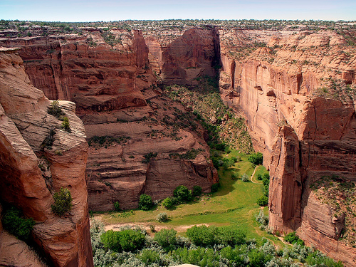
Canyon de Chelly National Monument is located in north-eastern Arizona on the border with the Navajo Nation. First natives that left evidence for their inhabitants were the ancient Pueblo People who were later followed by the Navajo tribes. Canyon de Chelly National Monument is a spectacular combination of natural beauty created by erosion and human activity who lived here in dwellings spread all along the canyon. Tourists should not forget that Canyon de Chelly is also a sacred place for Navajo Nation that venerate people who once lived here. Please respect their culture and traditions and don’t take souvenirs from any archaeological sites.
Getting There and Practical Basics
Location: Near Chinle, AZ
(about 3 miles from the Welcome Center via Indian Route 7 off US
191). It's roughly 5–6 hours from Phoenix or Albuquerque.
Operating Hours: The monument is open year-round. The Welcome Center
(with maps, bookstore, and info) is typically 8 AM–5 PM daily,
closed on major holidays like Thanksgiving, Christmas, and New
Year's. Overlooks are accessible 24/7.
Best Time to Visit: Spring
(March–May) and fall (September–October) for mild temperatures and
fewer crowds. Summers are hot (often >90°F/32°C) with monsoon risks
(July–September). Winters are cold with possible snow/ice. Early
morning or late afternoon visits beat the heat and improve lighting
for photos.
Elevation: Around 5,500 feet (1,680 m) — expect
high-desert conditions with big temperature swings.
Cell
Service/GPS: Spotty or unreliable on the Navajo Nation. Download
maps offline, use a physical road map, and share your plans with
someone. Stay on paved roads to avoid getting lost on unpaved
residential routes.
Rim Drives and Overlooks (Self-Guided)
These paved roads provide excellent free views without a guide. No
interpretive signs at most overlooks, so pick up info at the Welcome
Center or join a program.
South Rim Drive (recommended for
afternoon light): ~2 hours for 7 overlooks. Highlights include
Spider Rock (iconic twin spire, great for sunset).
North Rim
Drive (best morning light): ~2 hours for 3 overlooks, including
views into Canyon del Muerto.
Pro Tip: Do both rims for a full
picture. Start early on the North Rim, then switch to South.
Hiking and Canyon Floor Access
White House Trail (only
self-guided option currently): 2.5-mile round-trip from White House
Overlook on South Rim. Descends ~600 feet to the White House Ruins
(a major Ancestral Puebloan site). Steep and unshaded — go
early/late, bring water, know your limits. Note: Conditions can
change; it may have seasonal restrictions or future fees.
Canyon
Floor Tours (highly recommended): You must hire an authorized Navajo
guide for vehicle (jeep/OHV), hiking, or horseback tours. This is
the best way to experience the canyon's depth, petroglyphs, ruins,
and living Navajo culture (farms, hogans). Tours range from half-day
(~4 hours) to full-day. Expect to see more ruins, hear stories, and
navigate sandy/wet areas.Booking: Check the official Navajo Nation
list of operators (e.g., Canyon de Chelly Tours, Thunderbird Lodge,
Ancient Canyon Tours). Book ahead, especially in peak season. Many
hotels in Chinle can arrange.
Backcountry Permit: Required for
tours (~$15/person cash as of 2026; guide handles it). No pets on
tours.
Suggested Itineraries
2 Hours: South Rim overlooks
or North Rim + short White House hike.
Half Day: One rim + White
House Trail or half-day tour.
Full Day: Both rims + half-day tour
(ideal for first-timers).
2 Days: Full exploration + nearby sites
like Hubbell Trading Post or Navajo National Monument.
Camping and Lodging
Cottonwood Campground (Navajo Nation-managed,
near Welcome Center): First-come, first-served. ~$30/night (cash;
check current rates), no hookups/showers but clean facilities. Open
year-round under cottonwood trees. Group sites by reservation.
Nearby: Hotels/motels in Chinle (e.g., Thunderbird Lodge with
dining/gift shop). Limited services overall — stock up in town (gas,
groceries, fast food).
What to Bring and Safety Tips
Essentials: At least 1 gallon of water per person/day, snacks, sun
protection (hat, sunscreen, sunglasses, light layers), sturdy shoes,
camera/binoculars. No shade or facilities at many overlooks.
Desert/Flash Flood Safety: Drink often (before thirst), eat for
electrolytes, avoid midday heat. Flash floods possible even on clear
days — check forecasts and water levels. Stay on trails/roads.
Road/Livestock Hazards: Watch for animals (sheep, cows, horses,
deer) especially at night. Drive carefully; limited towing/repairs.
Cultural Respect: This is Navajo land with residents in the canyon.
Stay on designated paths, don't disturb ruins or artifacts, and
follow guide instructions. Drones prohibited.
Health: High
elevation/desert — pace yourself. Trails can be steep/exposed.
Additional Tips for an In-Depth Visit
Ranger Programs: Free
talks (Memorial Day–Labor Day) and occasional events — check at
Welcome Center or calendar.
Photography: Golden hours
(sunrise/sunset) are magical. Spider Rock and White House shine in
good light.
Accessibility: Some overlooks/rim areas are
accessible; check NPS for details.
Nearby Add-Ons: Combine with
Monument Valley Tribal Park or other Four Corners sites for a
broader Navajo lands trip.
Weather/Conditions: Check NPS alerts
and National Weather Service. Monsoons bring dramatic skies but
risks.
Etymology and Geology
The name derives from the Navajo Tséyiʼ (or
Tsegi), meaning "rock canyon" or "inside the rock." Spanish explorers
adapted it, leading to the English pronunciation. Geologically, the
canyons formed over millions of years through uplift and erosion of
colorful sandstone layers, creating sheer walls, alcoves, and fertile
alluvial floors with reliable water sources ideal for long-term
habitation.
Prehistoric and Ancient Inhabitants (Archaic to
Ancestral Puebloan Periods)
Human presence dates back to the Archaic
period (c. 2500–200 BCE), with mobile hunter-gatherers using seasonal
rock shelters. They hunted game (deer, antelope, rabbits) and gathered
over 40 plant varieties, gaining intimate knowledge of water sources
that later supported agriculture.
Basketmaker Period (c. 200
BCE–750 CE): A shift to agriculture occurred with the introduction of
corn (from the south), along with squash and beans. People became more
sedentary, building dispersed households, granaries, and public
structures. They excelled at basket weaving (hence the name) and created
rock art.
Pueblo Period / Ancestral Puebloans (Anasazi, c. 750–1300
CE): Villages emerged, with multistory stone-and-adobe cliff dwellings,
compounds, and kivas (ceremonial rooms) built in alcoves for protection,
sunlight, and defense. Famous sites include White House Ruins, Antelope
House, and Mummy Cave (Tse Yaa Kin, with ~165+ rooms). They farmed the
canyon floor, raised turkeys, grew cotton, made pottery, and created
sophisticated architecture and decorative plasters (white and green).
Rock art depicts hunters, animals, and symbols.
Around the
mid-1300s (c. 1300 CE), most Ancestral Puebloans left, likely due to
prolonged drought, resource stress, disease, conflict, or migration
patterns. Descendants include modern Pueblo and Hopi peoples.
Hopi
seasonal use (c. 1300–1700s): Hopi (descendants of Puebloans) returned
periodically for farming corn and peach orchards, maintaining cultural
ties through pilgrimages and traditions visible in homes and kivas.
Navajo (Diné) Era (1700s–Present)
Athabaskan-speaking Navajo
(Diné) arrived from the north (related to peoples in Canada/Alaska)
around the early 1700s, migrating from northern New Mexico. They adopted
and adapted elements from prior cultures, bringing sheep and goats,
building hogans, and establishing farms and orchards. Canyon de Chelly
became a heartland for corn, peaches, and herding, known regionally for
its fertility.
Conflicts arose in the late 1700s–early 1800s with
Spanish/Mexican forces, Utes, and others over livestock and land. The
canyons served as refuges with fortified trails and alcoves.
1805
Massacre: Spanish forces under Lt. Antonio Narbona attacked, killing
about 115 Navajo (mostly women, children, elders) in what is now called
Massacre Cave in Canyon del Muerto.
1860s and the Long Walk: In
1863–1864, U.S. Colonel Kit Carson led a scorched-earth campaign,
destroying hogans, orchards, crops, and livestock. Many Navajo were
killed or captured. Survivors endured the Long Walk—a forced march of
hundreds of miles to Bosque Redondo (Fort Sumner), New Mexico, where
thousands suffered from disease, starvation, and poor conditions
(1864–1868). The 1868 Treaty allowed return.
Post-return, Navajo
rebuilt amid hardship. Trading posts (e.g., Hubbell at Ganado; one at
the canyon) became community hubs.
Today, Diné families continue
traditional stewardship—farming, herding, and cultural practices—while
adapting. The canyon holds deep spiritual significance, with sites like
Spider Rock tied to stories (e.g., Spider Grandmother).
Establishment as a National Monument (1931–Present)
Interest grew in
the 19th century with U.S. military expeditions (e.g., Lt. J.H.
Simpson's 1849 descriptions) and archaeological surveys (James
Stevenson/Smithsonian 1882; Cosmos Mindeleff's mappings). Early
20th-century tourism and preservation efforts followed.
Authorized by
Congress on February 14, 1931 (signed by President Herbert Hoover), and
established April 1, 1931, primarily to protect archaeological
resources. It was a pioneering co-management model with the Navajo
Nation.
The NPS and Navajo Nation collaborate on preservation,
visitor management, and sustaining the living community. Challenges
include balancing tourism, resident rights, development (e.g., rim
moratorium), and threats like erosion, climate change, and invasive
species. Recent efforts use LiDAR and studies (e.g., at Tse Yaa
Kin/Mummy Cave) for documentation and conservation.
It was listed on
the National Register of Historic Places in 1970. Visitor numbers are
high (e.g., ~340,000 in 2025), drawn by scenery, ruins, and culture. Rim
drives offer views; guided tours access the floor.
Location and Overall Layout
The monument sits on the Defiance
Plateau, part of the broader Colorado Plateau physiographic province. It
includes three main canyons—Canyon de Chelly (the primary one, roughly
27 miles or 43 km long), Canyon del Muerto (about 18 miles or 29 km
long), and Monument Canyon (about 10 miles or 16 km long)—plus numerous
tributary canyons. These were incised by streams draining from the
Chuska Mountains to the east, which flow westward into Chinle Wash.
Elevation ranges from around 5,500 feet (1,680 m) on the canyon floor to
over 7,000 feet (2,130 m) on the rims, creating varied microclimates.
The canyon floors feature sandy washes (often dry but prone to flash
floods), fertile alluvial soils supporting agriculture, and riparian
zones with cottonwoods and other vegetation. The rims offer expansive
views of high desert mesas, pinyon-juniper woodlands, and distant
landscapes.
Key iconic features include:
Towering red
sandstone cliffs rising up to 1,200 feet (366 m) from the floor.
Erosion-resistant spires and buttes, most famously Spider Rock—an
800-foot (230–250 m) sandstone monolith (actually two spires) at the
junction of Canyon de Chelly and Monument Canyon.
Geology and
Formation
The dramatic landscape results from millions of years of
deposition, uplift, and erosion. The bedrock consists primarily of
Paleozoic and Mesozoic sedimentary rocks:
De Chelly Sandstone
(Permian, ~275–230 million years old, part of the Cutler Group): The
dominant formation forming the sheer, red-to-brown vertical cliffs. This
aeolian (wind-deposited) sandstone originated from vast desert dune
fields. It displays spectacular large-scale cross-bedding—curved,
swooping layers from ancient dune slip faces. Thickness reaches hundreds
of feet; it weathers into smooth, massive walls and resistant towers.
Underlying layers: Include the Supai Formation (Pennsylvanian–Permian),
visible at the base of features like Spider Rock (red-brown,
finer-grained).
Overlying caprock: Shinarump Conglomerate (part of
the Triassic Chinle Formation, ~200–230 million years old), a resistant
gravel layer that protects underlying sandstones and forms flat mesa
tops and some pinnacle caps.
Geologic history:
Sediments
accumulated in ancient seas, rivers, and deserts during the Permian and
Triassic.
The Laramide Orogeny (mountain-building ~50–70 million
years ago) and later uplift of the Defiance Plateau exposed these
layers.
Downcutting by streams (accelerated in the last 5–10 million
years) carved the canyons through differential erosion: softer layers
erode faster, leaving steep walls, alcoves, spires, and buttes.
Unconformities (gaps in the rock record) and other features like
joints/fractures influence erosion patterns, creating alcoves ideal for
ancestral cliff dwellings.
Topography and Landforms
Canyon
morphology: Narrow, steep-sided gorges with flat or gently sloping
floors of sand, gravel, and silt. Walls are often near-vertical due to
the resistant, jointed sandstone.
Erosional features: Mesas, buttes,
pinnacles, talus slopes, and alcoves. Tributaries create a dendritic
(branching) pattern.
Rim topography: Relatively flat plateau surfaces
with pinyon-juniper cover, dropping abruptly at the edges.
Drainage:
Ephemeral streams with spring snowmelt and summer monsoon flows.
Perennial springs and seeps support life on the floor. Flash flooding is
a hazard.
North and South Rim Drives provide access to overlooks
highlighting these features.
Climate, Flora, and Fauna
The
monument has a cold semi-arid climate (BSk) with hot summers (highs
often >90°F/32°C, extremes to 105°F), cold winters (lows below freezing,
extremes to -32°F), and ~9 inches (230 mm) of annual precipitation, much
from summer monsoons. Diurnal temperature swings are large.
Vegetation transitions with elevation:
Canyon floor: Riparian
(cottonwoods, willows), desert grassland/shrub, and agricultural fields
(corn, peaches, etc., cultivated by Navajo residents).
Rims and
higher areas: Pinyon-juniper woodland, with ponderosa pine, Douglas-fir,
aspen, and Gambel oak at upper elevations.
Wildlife: Diverse,
including 147 bird species, 49 mammals, 14 reptiles, etc. The canyons
provide habitat corridors and water sources in an arid region.