Location: Tulare County, CA Map
Area: 404,051 acres (1,635 km2)
Sequoia and Kings Canyon National Parks are two adjoining
national parks located in California's Sierra Nevada mountains.
Together, they showcase stunning alpine landscapes, including
towering peaks, lush conifer forests, deep glacial valleys, roaring
rivers, and world-famous groves of giant sequoia trees—the largest
trees on Earth by volume.
Although managed as separate entities,
these parks function as a unified area for visitors in many
respects. A single entrance fee provides access to both: currently
$35 per private vehicle or $20 per person (for those entering on
foot, bicycle, or motorcycle), valid for up to 7 days. (Note: As of
2026, non-U.S. residents aged 16 and older may incur an additional
$100 per person fee at these parks unless they hold a valid annual
or America the Beautiful pass.)
The combined area spans
approximately 865,952 acres (about 3,504 km²), with the vast
majority designated as wilderness backcountry, offering extensive
opportunities for remote hiking, backpacking, and solitude.
Elevations vary dramatically from around 1,300 feet (about 400 m) in
the lower foothills to 14,505 feet (4,421 m) at the summit of Mount
Whitney—the highest point in the contiguous United States.
The
more accessible "frontcountry" regions can be grouped into several
distinct areas: the Foothills (with oak woodlands and chaparral),
the iconic Giant Forest (home to many of the largest sequoias,
including the General Sherman Tree), Mineral King (a scenic
high-elevation valley), Grant Grove (featuring the General Grant
Tree and other giant sequoias), and the dramatic Kings Canyon and
Cedar Grove areas (known for sheer granite cliffs, waterfalls, and
the deep canyon carved by the Kings River).
Human presence in the
southern Sierra Nevada dates back at least 6,000–7,000 years.
Indigenous peoples, including the Monache (Western Mono) in the
higher mountains and western foothills, and the Yokuts in the lower
foothills and across the Great Central Valley, lived as hunters and
gatherers, relying on the land's abundant resources while practicing
sustainable stewardship. These groups, along with others like the
Tübatulabal, Paiute, and Western Shoshone, maintain deep cultural
and ancestral ties to the region today.
European exploration
began in the late 1700s and early 1800s with Spanish expeditions
probing the Sierra's edges. In the following decades, waves of
trappers, sheepherders, miners, and loggers arrived, drawn by the
mountains' resources. By the late 19th century, growing communities
in the San Joaquin Valley increasingly depended on the Sierra for
reliable water supplies and outdoor recreation. Amid conflicts among
logging interests, resource extraction, and emerging conservation
efforts, advocacy led to the creation of protected areas. Sequoia
National Park was established on September 25, 1890, by President
Benjamin Harrison, becoming the second national park in the U.S.
(and the first in California), initially created to safeguard the
giant sequoias from logging. Kings Canyon National Park followed
later, incorporating earlier smaller protections like General Grant
National Park.
Today, these parks preserve an extraordinary
cultural heritage, including 265 known Native American
archaeological sites and 69 historic sites. Sequoia National Park
itself stands as a historic landmark due to its pioneering role in
conservation. The parks are aptly named: Sequoia for its magnificent
groves of giant sequoia trees (Sequoiadendron giganteum), and Kings
Canyon for the profound, glacially sculpted valley etched by the
Kings River.
For the most up-to-date details, including operating hours, road
conditions, and any seasonal changes, visit the official park website:
nps.gov/seki (Sequoia & Kings Canyon National Parks).
Kings Canyon
Visitor Center
Located in the heart of Grant Grove Village along
Highway 180, approximately 3 miles (5 km) east of the Big Stump Entrance
Station. Perched at an elevation of about 6,500 feet (1,980 m) amid
stunning giant sequoia forests, this welcoming center serves as an
excellent starting point for exploring the park.
Here, visitors can
dive into the park's three iconic landscapes: the majestic giant sequoia
groves (home to ancient trees like the General Grant Tree), the dramatic
depths of Kings Canyon (also known as Cedar Grove in its lower reaches),
and the rugged beauty of the High Sierra backcountry.
Highlights
include:
A captivating 15-minute introductory film available in both
English and Spanish, offering stunning visuals and insights into the
parks' natural wonders.
Informative exhibits and displays that
highlight geology, ecology, wildlife, and human history.
A park store
stocked with books, topographic maps, souvenirs, educational items, and
gifts to enhance your visit.
Practical amenities such as accessible
restrooms, a pay phone (though cell service is limited), issuance of
local wilderness permits for backpacking adventures, and an AED
(automated external defibrillator) for emergencies.
Rangers are
often on hand to answer questions, provide trail advice, and share
current conditions—making this a must-stop for planning your day or
multi-day trip.
Lodgepole Visitor Center
Situated along the
Generals Highway, roughly 21 miles (34 km) north of the Ash Mountain
Entrance and about 2 miles (3 km) north of the world-famous General
Sherman Tree (the largest tree on Earth by volume). Nestled in the
conifer forest zone at an elevation of around 6,700 feet (2,040 m), this
center focuses on the rich natural and cultural history of the southern
Sierra Nevada region.
Key features include:
Engaging exhibits
exploring the area's ecosystems, wildlife (including the iconic black
bears), geology, and human stories from Indigenous peoples to early park
stewards.
A short, informative video titled "Bears of the Sierra",
which provides fascinating details on the park's black bear population,
their behavior, and important safety tips for visitors (such as proper
food storage to prevent conflicts).
This location is especially
popular in the Giant Forest/Lodgepole area, offering a great orientation
before heading out on nearby trails or to attractions like Tokopah Falls
or the Congress Trail.
These two adjacent national parks are situated in a remote area on
the western slopes of the Sierra Nevada mountains in California. They
are far from major urban centers and airports, and there is no public
transportation directly into or within Kings Canyon National Park.
Limited seasonal shuttle services operate only in Sequoia National Park
(primarily in the Giant Forest and Lodgepole areas during peak summer
and select holidays), with no connecting shuttles to Kings Canyon.
By Plane
The most convenient commercial airports are:
Fresno
Yosemite International Airport (FAT) — about 1¼ hours to the Kings
Canyon entrance (via Highway 180) and 1¾ hours to the Sequoia entrance
(via Highway 198).
Visalia Municipal Airport (VIS) — roughly 1 hour
to the Sequoia entrance and 1½ hours to Kings Canyon.
A smaller
option is Meadows Field Airport (BFL) in Bakersfield, about 2 hours
away. The nearest major international airport is Los Angeles
International Airport (LAX), around 4–5 hours' drive depending on
traffic and route.
All these airports offer car rental services,
which is the most flexible way to reach the parks. For a car-free option
to Sequoia, fly into Fresno or Visalia, then connect via local transit
to the Visalia Transit Center and take the seasonal Sequoia Shuttle
(operated by the City of Visalia) directly to the park.
By Train
The closest Amtrak stations are in Fresno and Hanford (along the San
Joaquins route, with connections like the San Joaquins Thruway bus or
the former San Joaquins branding). From Hanford (closer to Visalia), you
can transfer to a local bus or ride-share to the Visalia Transit Center,
then catch the summer Sequoia Shuttle to Sequoia National Park. Fresno
offers easier car rental access for driving to either park entrance.
Amtrak does not go directly to the parks, so plan for additional
transfers.
By Bus
Greyhound provides service to Fresno and
Visalia. In Visalia, head to the Transit Center for connections. The
highlight for public transit users is the Sequoia Shuttle from Visalia
(with pickups in areas like Three Rivers during the season), which costs
about $15 round-trip (as of the 2026 season) and includes unlimited
in-park shuttle access in Sequoia during summer. The service typically
runs from late May through early September (e.g., May 21–September 7 in
2026), with advance reservations strongly recommended via
sequoiashuttle.com or (877) 287-4453. Note: Riders need a valid national
park entrance pass (purchasable on Recreation.gov) to board and enter
the parks. No equivalent shuttle exists for Kings Canyon.
By Car
(Recommended for Most Visitors)
The parks are only accessible from
the west—no roads cross the Sierra Nevada from the east within the
parks. Expect winding, steep mountain roads with lower speed limits,
sharp turns, and potential winter hazards (tire chains often required
November–April; check nps.gov/seki for current conditions). Drive
cautiously, allow extra time, and watch for wildlife.
Main
entrances:
Highway 180 east from Fresno — Leads to the Big Stump
Entrance (Kings Canyon/Grant Grove area). This is the preferred and more
straightforward route for most vehicles, including larger ones like RVs.
From Grant Grove, the road splits: northeast toward the deeper Kings
Canyon (Cedar Grove area, seasonal access) or southeast to connect with
Sequoia. Recommended from Northern California or if heading straight to
Kings Canyon.
Highway 198 northeast from Visalia — Enters Sequoia
National Park at the Ash Mountain Entrance from the south. This is the
main route from Southern California. However, it features very tight,
winding sections on the Generals Highway. Vehicle restrictions apply:
vehicles longer than 22 feet (6.7 m) are not advised (and sometimes
prohibited) on the stretch from Potwisha Campground to Giant Forest
Museum; longer than 24 feet (7.3 m) not advised from the Foothills
Visitor Center to Potwisha. RVs and trailers should avoid this route or
use Highway 180 instead. Larger vehicles are barred from certain
southern sections just inside the entrance to Giant Forest.
Driving times (approximate):
From Fresno to northern entrance: ~1–1.5
hours to Grant Grove, plus 45–60 minutes to main park areas.
From San
Francisco: ~5 hours total (via northern entrance).
From Los Angeles:
~4–5 hours (via southern entrance, though some prefer the northern for
less winding roads inside the parks).
Mineral King Area (southern
Sequoia): Accessed via a separate, narrow, partially unpaved road off
Highway 198 in Three Rivers (turn right before the Ash Mountain
entrance). Not suitable for RVs/trailers; no connections to other park
areas.
Fuel Tip: No gasoline is sold inside the parks (except limited
emergency cans at Grant Grove Market). Fill up in nearby towns like
Three Rivers, Visalia, or Fresno, or in the national forest areas
between Grant Grove and Kings Canyon.
By Foot / Hiking Access
The eastern (high Sierra) portions of the parks are reachable via
trailheads along U.S. Highway 395 on the east side of the Sierra
(outside the main park areas). The famous Pacific Crest Trail (PCT) runs
along the high alpine crest through California, Oregon, and Washington,
passing through remote backcountry sections of these parks (from Mexico
to Canada overall). This is for experienced long-distance hikers with
proper permits and gear—backcountry wilderness access requires advance
planning via nps.gov/seki.
Entrance fees to Sequoia and Kings Canyon National Parks grant access
to both parks (they share a combined entrance system) and are typically
valid for 7 days, allowing unlimited re-entries during that period.
These parks are now cashless at entrance stations, so plan to pay with
credit/debit cards, mobile payments, or purchase passes in advance or
from authorized vendors.
As of 2026, the standard entrance fees
are:
$35 for a private, non-commercial vehicle (covers all passengers
in the vehicle).
$30 for a motorcycle (covers the rider and up to one
passenger, or multiple motorcycles in some cases).
$20 per person for
those entering on foot, by bicycle, or other non-motorized means
(applies to individuals age 16 and older).
There's also a
park-specific Sequoia & Kings Canyon Annual Pass for $70, which provides
unlimited entry for one year (from the month of purchase) to both parks
and the adjacent Hume Lake Ranger District of Sequoia National
Forest/Giant Sequoia National Monument. This is ideal for frequent
visitors or locals.
Important note for international visitors:
Starting in 2026, non-U.S. residents aged 16 and older must pay an
additional $100 per person surcharge on top of the standard entrance fee
when visiting Sequoia & Kings Canyon (and certain other high-demand
national parks), unless they hold a valid Annual or America the
Beautiful Pass. This policy aims to prioritize affordable access for
American taxpayers.
The America the Beautiful – The National Parks
and Federal Recreational Lands Pass (also known as the Interagency Pass)
is a great option for broader access. It covers entrance fees (and
standard amenity/day-use fees) at national parks, many national
monuments, wildlife refuges, forests, and other federal recreation sites
managed by agencies like the NPS, USFS, and more. For a private vehicle,
one pass covers the entire group; for per-person entries, it covers the
passholder plus up to three adults.
Key types of America the
Beautiful Passes include:
Resident Annual Pass — $80 (for U.S.
citizens and residents); valid for 12 months from the date of issue.
Non-Resident Annual Pass — $250 (available to anyone, including non-U.S.
residents); helps avoid the per-person surcharge at applicable parks.
Senior Annual Pass — $20 (for U.S. citizens or permanent residents aged
62+); renewable yearly.
Senior Lifetime Pass — $80 (for U.S. citizens
or permanent residents aged 62+); one-time purchase.
Military Annual
Pass — Free (for current U.S. military members and dependents; show
Common Access Card or Military ID).
Military Lifetime Pass — Free
(for U.S. veterans and Gold Star families—those who lost servicemembers
in action; requires documentation).
Access Pass — Free (lifetime; for
U.S. citizens or permanent residents with permanent disabilities;
requires proof of citizenship and disability).
Volunteer Pass — Free
(for those who have volunteered 250+ hours with participating federal
agencies).
Every Kid Outdoors 4th Grade Pass — Free (annual; for U.S.
4th graders and accompanying passengers in a private non-commercial
vehicle; valid from September through August of the school year;
requires registration at the Every Kid Outdoors website).
Senior,
Access, and certain military passes also offer a 50% discount on some
park amenities, such as camping fees or other services (though not all
fees, like concessioner-operated ones).
The National Park Service
provides free admission to all national parks (including Sequoia and
Kings Canyon) on several designated days each year—for U.S. citizens and
residents only in 2026 (non-residents pay standard fees plus any
applicable surcharges). Other fees (e.g., camping, timed entry if
required) may still apply. The 2026 fee-free dates are:
February
16: Presidents Day (Washington's Birthday)
May 25: Memorial Day
June 14: Flag Day (and President Trump's birthday)
July 3–5:
Independence Day weekend
August 25: National Park Service 110th
Birthday
September 17: Constitution Day
October 27: Theodore
Roosevelt's birthday
November 11: Veterans Day
By car
The main roads through both parks wind through
high-elevation terrain, featuring steep grades, sharp curves, and slower
driving speeds—expect to take your time and enjoy the scenic views along
the way. Navigation is fairly simple thanks to clear signage.
In
Sequoia National Park, the primary route is Highway 198 (Generals
Highway), which enters from the southwest at the Ash Mountain Entrance.
It heads north through the park's key highlights, including the Giant
Forest area with its famous giant sequoias (most major sights, like the
General Sherman Tree, Moro Rock, and Crystal Cave turnoffs, are
accessible via well-marked side roads branching off the main highway).
This road eventually connects with Highway 180 at Grant Grove, right
near the Big Stump (western) entrance.
In Kings Canyon National Park,
Highway 180 serves as the main thoroughfare. It continues from Grant
Grove northward and then eastward, leading to the dramatic Cedar Grove
area deep in the canyon, home to stunning viewpoints, trails, and the
Kings River.
Parking is usually plentiful at most major attractions
and trailheads throughout both parks, though it can fill up quickly
during peak summer weekends and holidays—arriving early helps.
By
free in-park shuttle
Sequoia National Park operates a seasonal,
fare-free shuttle service (operated by the National Park Service) in the
busy Giant Forest and Lodgepole areas. These shuttles connect popular
spots like the Giant Forest Museum, General Sherman Tree trailhead, Moro
Rock, Wolverton, Wuksachi Lodge, and Lodgepole Campground. Service
typically runs during the peak summer season (late May through early
September) and on select winter holiday periods (such as late December
to early January, and certain holiday weekends). The shuttles are
wheelchair accessible, help reduce traffic and parking hassles, and
promote a more relaxed experience amid the sequoias.
There is no free
in-park shuttle service in Kings Canyon National Park—visitors rely
primarily on private vehicles to explore areas like Grant Grove and
Cedar Grove.
(Note: A separate paid service, the Sequoia Shuttle,
runs round-trip from Visalia to the park during summer, with unlimited
in-park connections, but that's distinct from the free NPS-operated
shuttles inside Sequoia.)
Always check the official NPS website
(nps.gov/seki) for current schedules, road conditions, and any seasonal
changes before your visit, as weather can affect operations.
Driving through Sequoia and Kings Canyon National Parks often
immerses visitors in intimate, close-up encounters with towering trees
and dense forests. However, don't miss the occasional roadside pullouts
and vista points that offer breathtaking panoramic views—these are well
worth stopping for.
The drive along the road to Cedar Grove (in
Kings Canyon) rewards travelers with numerous stunning overlooks of the
dramatic, narrow Kings Canyon, showcasing sheer granite walls, the
rushing Kings River far below, and the surrounding High Sierra
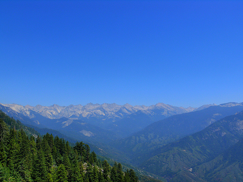
landscape.
Between Grant Grove and Lodgepole, there's typically just
one primary lookout point, but it delivers an impressive vista of the
rugged Sierra Nevada mountains, including distant peaks and forested
slopes.
The steep, twisting descent from the Giant Forest area down
to the Ash Mountain entrance provides several rewarding glimpses of the
scenic Kaweah River valley, with its cascading waters, oak woodlands,
and rolling foothills below.
Both parks boast an incredible
diversity of wildlife, from graceful deer grazing in meadows to a
variety of colorful birds and the iconic black bears (always practice
proper food storage and keep a safe distance).
Visitor Centers
These hubs offer exhibits, park information, maps, books, and
educational items to enhance your visit.
Cedar Grove Visitor
Center — Located on Highway 180, about 30 miles (48 km) east of Grant
Grove, right next to Sentinel Campground. Nestled beside the South Fork
of the Kings River in a mixed conifer forest at around 4,600 feet (1,400
m) elevation. It focuses on the natural and cultural history of the
Cedar Grove area, with accessible restrooms and a pay phone available.
Foothills Visitor Center — Situated on the Generals Highway, just 1 mile
(1.6 km) north of the Ash Mountain Entrance. Set amid foothills oaks and
chaparral at a lower elevation of 1,500 feet (457 m). This center
highlights the biologically rich Sierran foothills zone, the most
diverse ecosystem in the parks.
Giant Forest Museum — Found on the
Generals Highway, 16 miles (26 km) north of the Ash Mountain Entrance.
Housed in a charming historic building within the Giant Forest sequoia
grove at 6,500 feet (1,980 m). It emphasizes giant sequoia ecology, the
role of fire in the ecosystem, and provides essential park info along
with a small bookstore.
Mineral King Ranger Station — Positioned on
the Mineral King Road, 24 miles (39 km) from Highway 198 in Three
Rivers. In a mixed-conifer forest at 7,600 feet (2,320 m). This compact
station features exhibits on the area's human and natural history, sells
books/maps/educational items, provides bear canisters, has a pay phone
in the nearby campground, offers first aid, and issues local wilderness
permits.
Sequoia National Park Highlights
Grant Grove — A
magnificent stand of giant sequoias near the western entrance to the
parks.
General Grant Tree — Famous as the "Nation's Christmas
Tree," this massive sequoia holds special historical significance and is
beautifully illuminated during holiday events.
Fallen Monarch — A
huge fallen sequoia right beside the General Grant Tree; visitors can
walk through its hollow interior, offering a fun sense of scale to these
ancient giants.
Giant Forest — The heart of Sequoia, this central
collection of sequoia groves lies a few miles south of the main visitor
areas. It features the General Sherman Tree, recognized as the largest
tree on Earth by volume and weight (measuring about 275 feet tall with a
base circumference over 100 feet). Explore via an easy 1-2 mile looping
trail around the museum area. Note: The main parking is about 0.4 miles
uphill from the grove at around 7,000 feet elevation—those with mobility
concerns or planning a leisurely visit might arrange a ride back up the
hill.
Moro Rock-Crescent Meadow Road — A scenic 3-mile (5 km)
side road branching off the Generals Highway near the Giant Forest
Museum. It accesses several southern Giant Forest features (not
recommended for trailers or large RVs).
Moro Rock — A striking
granite dome with a steep, quarter-mile (0.4 km) staircase climb to the
summit (gaining about 300 feet/91 m). The top offers jaw-dropping
360-degree views of Sequoia's high peaks, the Great Western Divide, and
vast wilderness—though the narrow stairs with sheer drop-offs make it
unsuitable for those with a fear of heights.
Tunnel Log — A fallen
sequoia with a natural tunnel carved through it, allowing most cars to
drive straight through (a bypass exists for taller vehicles). It's a
short, fun detour near Moro Rock—definitely stop if you're in the area.
Auto Log — Once a popular spot where visitors drove cars onto a massive
fallen sequoia log for photos, but natural decay has made it unsafe, so
driving on it is no longer permitted.
Crescent Meadow — A picturesque
high-Sierra meadow bursting with vibrant wildflowers during summer,
surrounded by sequoias and offering peaceful trails for strolling or
picnicking. It's a serene spot to appreciate the park's alpine beauty.
Both Sequoia and Kings Canyon National Parks offer an extensive
network of trails ideal for hiking and backpacking, along with some
opportunities for horseback riding through designated facilities and
guided services in certain areas.
Day Hikes
Here are some
popular and rewarding day hike options across the parks:
Alta Peak:
This is a challenging, longer day hike leading to a rugged,
high-elevation summit at about 11,204 feet. It rewards hikers with
stunning panoramic views of the Great Western Divide and, on clear days,
even distant sights of Mount Whitney. The most convenient starting point
is the Wolverton trailhead, located just south of Lodgepole in the Giant
Forest area. Expect a strenuous outing with significant elevation gain
(around 4,000+ feet) over roughly 13-14 miles round-trip, typically
taking 8-10 hours.
Big Stump Trail: Situated near the Big Stump
Entrance in Kings Canyon National Park, this easy 2-mile loop trail
winds through a historic sequoia grove that was heavily logged in the
late 1800s. It provides a fascinating look at the remnants of old-growth
giant sequoias, large stumps, and the effects of early logging, offering
an educational and scenic stroll amid regenerating forest.
Crystal
Cave Tours — Crystal Cave Road (about 15 miles/24 km from the Sequoia
Park entrance on Highway 198, and roughly 3 miles/5 km south of the
General Sherman Tree; note the road has a maximum vehicle length of 22
feet/6.7 m). ☏ +1 559 565-3759 (or check the Sequoia Parks Conservancy
for current contact).
This guided tour explores a stunning marble
cavern adorned with intricate, water-sculpted formations like
stalactites, stalagmites, and flowstone. The cave maintains a constant
cool temperature of around 50°F (10°C), so wear layers and closed-toe
shoes with good traction. The tour involves a moderate half-mile
round-trip hike to the entrance with steep sections and stairs.
Restrictions include: no strollers, tripods, baby backpacks, or
wheelchairs (not accessible); photography rules may apply.
Tickets
must be purchased in advance online through the Sequoia Parks
Conservancy website (often selling out weeks or months ahead, especially
in peak summer); they are not sold at the cave itself. Buy them at least
36 hours prior, ideally much earlier. As of recent seasons, standard
tours last about 50 minutes to 2 hours depending on the type, with
pricing around Adults $20, Children $10 (subject to change—check the
official site for the latest). Tours are typically offered daily in
summer, but schedules vary (e.g., limited days in shoulder seasons).
Lookout Peak: An accessible day hike starting from the Grant Grove area.
It provides excellent views, particularly appealing in winter when the
road to Cedar Grove is closed, offering a similar vantage point to more
distant overlooks without the longer drive. The trail is considered
relatively easy to moderate, making it a great option for varied
conditions.
Mist Falls Hike: A scenic and popular day hike in Kings
Canyon, leading past rushing rapids and cascades to one of the parks'
most impressive waterfalls. It's a solid moderate outing (around 8 miles
round-trip with modest elevation gain of about 600 feet), ideal when
exploring the Cedar Grove region in summer.
Tokopah Falls: A
relatively easy and refreshing day hike near Lodgepole in Sequoia
National Park. This approximately 3.4-3.5 mile round-trip trail follows
the Marble Fork of the Kaweah River through forested terrain to a
dramatic 1,200-foot cascading waterfall, which is especially powerful in
late spring/early summer. It's a great choice for families or those
seeking a scenic, low-to-moderate effort hike with granite cliffs and
valley views.
Dining and Supplies
Basic food services,
groceries, and shops are conveniently available at the main visitor
centers in Grant Grove, Lodgepole, and Cedar Grove. Options include
casual dining spots, snacks, and limited supplies. For overnight stays
or longer visits, it's highly recommended to stock up on food and
essentials before entering the park, as in-park selections can be
limited and prices higher—pick up items in nearby towns like Three
Rivers, Visalia, or Fresno en route. Always check current conditions and
availability on the official NPS website, as facilities and access can
vary seasonally.
Visitors to Sequoia and Kings Canyon National Parks have several
comfortable lodging choices within the parks, primarily managed by
Delaware North Parks & Resorts. These include:
Wuksachi Lodge in
the Lodgepole area (Sequoia section): This modern, stone-and-cedar
mountain lodge offers spacious guest rooms with stunning views, a
full-service restaurant, and convenient access to major attractions like
Giant Forest. It is typically open year-round but may have temporary
closures for maintenance (check current status, as it was temporarily
closed with a planned reopening in March 2026).
John Muir Lodge and
Grant Grove Cabins in Grant Grove Village (Kings Canyon section): The
lodge provides cozy hotel-style rooms in a serene setting near the
famous General Grant Tree, while the cabins offer a more rustic
experience with timber and tent-style options. Both are seasonal, often
closed in winter and reopening in spring (e.g., planned for spring
2026).
Cedar Grove Lodge in Cedar Grove (Kings Canyon section): This
smaller lodge features comfortable rooms with private baths, air
conditioning, and proximity to canyon-floor attractions like Zumwalt
Meadow. It operates seasonally, typically from spring through fall, and
closes for winter (e.g., reopening in spring 2026 after seasonal
closure).
Advance reservations are strongly recommended for all
in-park lodging, especially during peak summer months, as availability
fills quickly. Book through the official operator at visitsequoia.com or
by calling (866) 807-3598. Note that some lodges may be closed during
off-seasons or for maintenance—always verify current openings on the NPS
website or the operator's site.
Outside the parks, you'll find
additional options, including various hotels, motels, and rustic lodges
in Sequoia National Forest (along the road between Grant Grove and Cedar
Grove) and in nearby towns like Three Rivers (near the southwest
entrance on Highway 198). These provide more flexibility and amenities
if in-park spots are booked.
Camping in the Parks
Camping remains
the most popular and immersive way to stay overnight in Sequoia and
Kings Canyon National Parks, with 14 campgrounds spread across different
areas and elevations. Most sites accommodate up to six people and
include a picnic table, fire ring with grill, and a bear-proof metal
food-storage locker (essential due to active black bears in the area).
Campers must store all food, trash, and scented items in these lockers
or bear-proof containers when not in use—rangers enforce this strictly
to protect wildlife and visitors.
Reservations are required for
nearly all campgrounds during peak season (typically summer), with sites
often booking up months in advance via Recreation.gov. Some
lower-elevation or off-peak sites may be first-come, first-served. Fees
have increased in recent years; as of recent updates, standard sites are
generally $32 per night (with discounts for Senior/Access Pass holders),
group sites range from $50–$80 depending on size, and stock sites are
$40. Fees are separate from park entrance fees ($35 per vehicle standard
pass).
Here are details on key campgrounds:
Atwell Mill
Campground — Located in the remote Mineral King area (19 miles/31 km
from Highway 198 on Mineral King Road, 6 miles/10 km before the road
ends). Offers 21 tent-only sites in a former logged sequoia grove along
the East Fork of the Kaweah River. Limited services at nearby Silver
City Resort (1.7 miles/3 km east); more in Three Rivers (23 miles/37 km
west). Fee: Around $32/night (recent rates; tent-only, no RVs/trailers).
Azalea Campground — In Grant Grove area, 3.5 miles/5.6 km from Kings
Canyon entrance. 110 sites under open evergreen stands; first-come,
first-served in some seasons. Services in Grant Grove Village. One of
the few year-round options. Fee: Around $32/night.
Buckeye Flat
Campground — On Generals Highway, 6 miles inside via Highway 198 through
Three Rivers. 28 sites along the Middle Fork of the Kaweah River under
oaks. Services in Three Rivers near Ash Mountain Entrance. Note: Closed
in recent years (including 2025) due to storm damage—check current
status. Fee: Around $32/night when open.
Canyon View Group Campground
— In Cedar Grove area, 32 miles from Kings Canyon entrance on Highway
180 (0.25 miles from Cedar Grove Village). 16 group sites along the
South Fork of the Kings River canyon floor. Ideal for medium/large
groups. Services in Cedar Grove Village. Fees: $50–$80 depending on
group size.
Cold Springs Campground — Mineral King area (23 miles/37
km from Highway 198 on Mineral King Road). 40 sites (including walk-to)
near Mineral King Visitor Center amid aspens and conifers. Limited
services at Silver City Resort (2.5 miles/4 km west); more in Three
Rivers (27 miles/44 km west). Tent-only, no RVs. Fee: Around $32/night.
Crystal Springs Campground — Grant Grove area (4 miles/6 km from
entrance on Crystal Springs Road). 50 individual sites + 14 group sites
under evergreens. Groups reservable; individuals often first-come,
first-served. Services in Grant Grove Village. Fee: Around $32/night
standard, higher for groups.
Dorst Creek Campground — 10 miles/16 km
north of Giant Forest. 222 sites + 4 group sites under evergreens.
Services nearby at Wuksachi Lodge, Stony Creek, or Lodgepole Village.
Note: Often closed in recent seasons due to tree hazards—verify status.
Fee: Around $32/night standard, $50–$80 groups.
Lodgepole Campground
— In fir forest along Marble Fork of Kaweah River (Lodgepole area). 204
sites. Very popular; services just 0.25 miles away in Lodgepole Village
(market, showers, etc.). Often requires advance reservations. Fee:
Around $32/night.
Moraine Campground — Cedar Grove area (0.75 miles
from Cedar Grove Village on Highway 180). 121 sites on canyon floor
along South Fork of Kings River. Offers some of the best views of Kings
Canyon's dramatic granite cliffs. Services in Cedar Grove Village. Fee:
Around $32/night.
Potwisha Campground
Located on the Generals
Highway, approximately 3.7 miles past the Ash Mountain Entrance in
Sequoia National Park. Access the park via Highway 198 through the
charming town of Three Rivers. This campground features 42 sites
suitable for tents and smaller RVs. Nestled along the Middle Fork of the
Kaweah River beneath a spacious grove of oak trees, it offers a scenic
riverside setting with the soothing sounds of flowing water. Summers
here can be quite hot due to its lower elevation in the foothills, but
winters are generally mild and snow-free, making it a year-round option
(weather permitting). Basic amenities include picnic tables, fire rings,
bear-proof food lockers, flush toilets, and drinking water. The nearest
services—including groceries, fuel, and dining—are available in Three
Rivers, just outside the entrance. Current nightly fee is around $32 for
standard sites (up from $22 in 2020; check Recreation.gov for exact
rates and reservations, which are recommended).
Sentinel
Campground
Positioned on Highway 180, just 0.25 miles from Cedar
Grove Village in Kings Canyon National Park. It offers 82 sites for
tents and RVs. Set in a dramatic canyon along the South Fork of the
Kings River, the campground is shaded by open stands of evergreen trees,
providing a cooler, more forested atmosphere compared to lower-elevation
areas. The rushing river nearby adds to the peaceful ambiance, and it's
a great base for exploring nearby trails and the stunning Cedar Grove
area. Amenities include picnic tables, fire rings, bear boxes, flush
toilets, and potable water. Services such as a small market, showers,
and laundry are conveniently located in Cedar Grove Village. Nightly fee
is typically $32 for tent or RV sites (updated from $18 in 2020;
reservations via Recreation.gov are highly advised, especially in peak
season).
Sheep Creek Campground
Also on Highway 180, about
0.25 miles from Cedar Grove Village in Kings Canyon. With 111 sites,
it's one of the larger options in the area. This campground sits on the
canyon floor right at the confluence of the South Fork of the Kings
River and Sheep Creek, offering prime river access and a mix of open and
shaded spots under trees. It's ideal for those seeking a scenic,
water-focused stay with opportunities for fishing, wading, or simply
relaxing to the sound of the streams. Amenities mirror nearby
campgrounds: picnic tables, fire rings, food storage lockers, flush
toilets, and drinking water. All services are available in Cedar Grove
Village. Standard nightly rate is around $32 (increased from $18 in
2020; book ahead on Recreation.gov).
South Fork Campground
To
reach it, take Highway 198 to Three Rivers, then turn onto South Fork
Road about five miles before the main Sequoia entrance. Drive east for
roughly 12.3 miles—the paved road ends shortly before the campground,
transitioning to a dirt road leading to the sites and the Ladybug
Trailhead. This small, primitive campground has only 10 sites, all
first-come, first-served (no reservations). Tucked in a remote foothill
area along the South Fork of the Kaweah River, it marks the transition
zone from oak woodlands to evergreen forests, offering a quieter, more
rustic experience away from crowds. Two trails start nearby: the
Garfield Grove Trail (leading to giant sequoias) and the Ladybug Trail
(great for wildflowers and views). Other major park attractions are over
an hour's drive away, so it's best for those wanting seclusion. The dirt
road can be rough—high-clearance vehicles are recommended, and
low-clearance cars should avoid it. Fees are free in winter and around
$12 in summer (2020 rates; confirm current status as it may vary or
close seasonally—South Fork has been noted as closed in some recent
seasons).
Sunset Campground
Situated about 3 miles (5 km) from
the Kings Canyon Park entrance, near Grant Grove Village. It boasts 159
individual sites plus 2 group sites. Located in an open stand of
evergreen trees at a higher elevation, it provides cooler temperatures
and beautiful sunset views over the surrounding landscape. This makes it
a popular choice for families and groups exploring the Grant Grove area,
home to the General Grant Tree and other giant sequoias. Amenities
include standard picnic tables, fire rings, bear-proof lockers, flush
toilets, and water. Services are readily available in Grant Grove
Village (market, restaurant, etc.). Nightly fees are typically $32 for
tent or RV sites, with group sites A & B around $40–$80 depending on
size (updated from 2020 rates; reservations essential via
Recreation.gov).
Backcountry Camping
The High Sierra regions
of Sequoia and Kings Canyon National Parks are a true paradise for
backpackers, with countless trails winding through Kings Canyon and
branching out from the Mineral King area, offering stunning alpine
lakes, meadows, peaks, and sequoia groves. A wilderness permit is
required for all overnight stays in the backcountry. During peak season
(generally mid-May to late September), permits cost $15 per permit
(non-refundable reservation fee) plus $5 per person, and they are
subject to daily entry quotas at each trailhead—once the quota fills, no
additional permits are issued that day. Popular trailheads often book up
months in advance during summer, so early reservations through
Recreation.gov are strongly recommended. Outside the quota season,
permits are free, have no quotas, and are issued only in person at park
visitor centers. For the latest on quotas, open dates, trail conditions,
and visitor center locations, consult Recreation.gov or the official
National Park Service pages for Sequoia and Kings Canyon Wilderness.
Always practice Leave No Trace principles and be bear-aware with proper
food storage.
Emergency Response
In any emergency situation within Sequoia and
Kings Canyon National Parks, immediately dial 911 from any phone—it's
toll-free and connects directly to dispatch for rapid assistance.
Wildlife Precautions
The parks are home to diverse wildlife, and
respecting their space is crucial for both visitor safety and animal
well-being.
General Rule: Never feed, approach, or touch any wild
animals. Feeding them can lead to aggressive behavior, property damage,
or euthanasia of the animal. Maintain safe viewing distances: at least
75 feet (about two school buses) for most wildlife, and 150 feet (about
four school buses) or more for bears.
Rattlesnakes: These venomous
snakes are common in lower elevations. Always watch your step,
especially on rocky trails or off-path areas, and avoid placing hands or
feet in unseen spots like crevices or under logs.
Plague Risk: Fleas
on rodents and other mammals (such as ground squirrels) can carry
plague. Avoid handling dead animals or close contact with rodents.
Mountain Lions (Cougars): These elusive predators are present but rarely
encountered. They resemble large, light-brown cats (5–8 feet long
including tail). If you spot one, do not run (as this triggers chase
instinct), approach it, or turn your back. Instead, pick up small
children or pets immediately. Face the animal, make direct eye contact,
raise your arms to appear larger, speak firmly, and back away slowly. If
it advances, shout loudly, wave arms aggressively, and throw rocks,
sticks, or other objects to deter it. In the rare case of an attack,
fight back fiercely—do not play dead.
Black Bears: The parks are
prime black bear habitat (they can appear black, brown, or
cinnamon-colored), and sightings are common. Never approach or feed
them—maintain at least 100 yards (about a football field) distance.
Avoid getting between a mother and her cubs, as this is extremely
dangerous. Bears that obtain human food can become habituated, leading
to vehicle break-ins, tent raids, or aggression.
Food Storage Rules
(strictly enforced by park regulations): Store all food, scented items
(toiletries, trash, pet food, even non-edibles like sunscreen or air
fresheners), and coolers in provided bear-resistant metal boxes at
campsites, picnic areas, and trailheads. Lock boxes fully. In vehicles,
use the trunk (out of sight, windows closed); never leave food
unattended. In backcountry areas, follow wilderness storage guidelines.
Proper storage protects both people and bears—violations can result in
fines or impounded items.
In Encounters: Back away slowly if
possible; make noise to alert the bear of your presence in advance on
trails. Report sightings or incidents to rangers.
Ticks and Lyme
Disease: Ticks are widespread and can transmit Lyme disease or other
illnesses. Prevent bites by wearing long pants tucked into socks, long
sleeves tucked into pants, and using insect repellent. After outdoor
activities, thoroughly check yourself, clothing, and pets. If a tick is
attached, remove it carefully with fine-tipped tweezers (grasp close to
skin and pull steadily), clean the area, and consult a ranger or doctor
promptly. Check dogs thoroughly too, as they can carry ticks home.
Natural Hazards
The parks' rugged environment includes several
risks from plants, water, and weather.
Poison Oak: Common up to about
5,000 feet (1,500 m) elevation, this plant causes severe itchy, burning
rashes that spread easily via oils on skin or clothing. Learn to
identify it (often "leaves of three," reddish in fall, bare in winter)
from trailhead bulletin boards. If contact occurs, wash skin and clothes
immediately with soap and cool water. Products like Tecnu (available at
camping or drug stores) help remove the oil. Avoid touching eyes.
Drinking Water: Never drink untreated water from streams, lakes, or
springs—it may contain Giardia or other pathogens causing severe
intestinal illness. Always filter, treat with chemicals, or boil water
before drinking.
Lightning: A serious threat during storms,
especially on ridges, rock outcrops, open meadows, or near tall trees.
If thunder roars, seek shelter in a hard-topped vehicle or sturdy
building. Avoid isolated trees, shallow caves, open fields, or water.
Crouch low if caught outside, but do not lie flat.
Driving Safety
Park roads are steep, winding, and narrow—many with sharp drop-offs.
Use low gears on downhill sections to prevent brake overheating or
failure.
Slower vehicles must pull over at turnouts to allow passing.
In winter, roads can be icy or snow-covered; tire chains may be required
(check restrictions). For current road conditions, call (559) 565-3341
(press 1, then 1 again for 24-hour updates). Outside park roads: check
Caltrans at (800) 427-7623.
For 24-hour emergency towing or roadside
assistance (out-of-gas, lockouts, jump-starts, minor repairs), contact
the park at (559) 565-3341 (press 0) or AAA services in Sequoia at (559)
565-4070.
Crime and Illegal Activities
Due to the parks'
remote wilderness areas, illegal marijuana grows occasionally occur on
public lands. If you stumble upon a suspicious cultivation site (often
with irrigation, plants, or equipment), do not investigate or linger—the
operators may be armed and dangerous. Leave the area immediately, note
the location if safe, and report it promptly to park rangers or law
enforcement.
Prehistory and Indigenous Peoples
The history of Sequoia National
Park begins long before European arrival, with evidence of human
habitation dating back to at least AD 1000. The region was primarily
home to the Western Mono (also known as Monache) people, who lived in
the Kaweah River drainage in the foothills, with seasonal camps
extending up to the Giant Forest area. Estimates suggest a population of
around 2,000 permanent residents. In the eastern parts, along the Kern
River drainage, the Tübatulabal people used the land as summer hunting
grounds. These Indigenous groups traveled across high mountain passes to
trade with eastern tribes and employed controlled burns to manage the
landscape, aiding in hunting, agriculture, and promoting natural
vegetation growth. This practice significantly shaped the ecology of the
Sierra Nevada. Pictographs at sites like Hospital Rock and Potwisha,
along with bedrock mortars for processing acorns—a staple food—attest to
their presence. Other groups, such as the Yokuts, Paiute, and Western
Shoshone, also utilized, tended, and valued the high Sierra lands,
including subalpine and alpine habitats, maintaining deep cultural
connections to the area. The Monache subtribes, including the Potwishas
and Wuksachis, established year-round villages in the foothills near
what is now Sequoia's Ash Mountain entrance, with seasonal movements
into the forests.
European Exploration and Early Settlement
European contact with the region started in the early 19th century. The
first recorded European exploration came in 1806 when Spanish explorer
Gabriel Moraga named the Kings River "El Río de los Santos Reyes" during
the Epiphany, which was later shortened to Kings River. However, the
Sierra Nevada remained largely untouched by outsiders until 1827, when
fur trappers entered the area. The California Gold Rush of 1849 brought
a surge of settlers, leading to abandoned mines, particularly in the
Mineral King area, which was prospected for silver in the 1870s but
yielded little success.
The first European settler in the core area
was Hale Tharp, who arrived in 1858 and built a home inside a
hollowed-out fallen giant sequoia log in the Giant Forest, near Log
Meadow. Tharp encountered Native American groups, including one of about
600 people, and was shown the Giant Forest by friendly Western Mono
individuals. By the 1860s, more settlers followed, but epidemics of
smallpox, measles, and scarlet fever devastated the Indigenous
populations between 1860 and 1863, leading to the abandonment of major
sites like Hospital Rock by 1865. After the Native Americans' departure,
settlers like Tharp allowed sheep and cattle to graze the meadows,
though some respected the sequoias' grandeur and opposed logging. Tharp
hosted notable visitors, including naturalist John Muir, who stayed in
his log cabin (now preserved as Tharp's Log).
The 19th-Century
Logging Rush and Rising Conservation Efforts
The late 19th century
saw intense exploitation of the giant sequoias, driven by rumors of
their lumber potential following the Gold Rush. Companies like the Kings
River Lumber Company acquired vast tracts through fraudulent land
claims, targeting groves like Converse Basin, which once held over 8,000
sequoias. Logging operations began in earnest around 1892, using axes,
saws, and steam-powered "donkeys" to fell trees, which often shattered
upon impact due to their brittle wood. Logs were transported via greased
chutes and a 54-mile flume to mills, but the process was wasteful—up to
half the wood was left on the ground—and financially disastrous due to
high infrastructure costs. This era destroyed about a third of the
ancient sequoias in the region, obliterating Converse Basin and leaving
only stumps, with the Boole Tree as a rare survivor.
In the 1880s,
white settlers established the Kaweah Colony, a utopian socialist
community based on logging sequoias for economic gain. However, the
trees proved unsuitable for timber as they splintered easily, though
thousands were still felled before operations halted. Grazing by sheep,
sawmills, and dams also threatened the landscape. This destruction
galvanized conservationists, including John Muir, who arrived in the
Sierra Nevada in 1868, worked as a shepherd and sawmill operator, and
became a vocal advocate for wilderness preservation through his writings
and co-founding of the Sierra Club in 1892. Muir influenced President
Theodore Roosevelt during a 1903 camping trip, promoting a vision for
national parks. Tharp and others engaged in early anti-logging efforts,
setting the stage for federal protection.
Establishment of
Sequoia National Park
The rampant logging prompted urgent action. On
September 25, 1890, President Benjamin Harrison signed legislation
establishing Sequoia National Park as America's second national park
(after Yellowstone), specifically to protect the giant sequoia trees
from further destruction—making it the first park created to safeguard a
living organism. The bill, introduced by Representative William
Vandever, passed Congress unanimously and protected 404,064 acres of
forested mountainous terrain. A week later, on October 1, 1890, General
Grant National Park (four square miles around Grant Grove) was
established. This came too late for some areas like Converse Basin but
preserved key groves.
Early Management and Development
Initially, no agency oversaw the parks, so the U.S. Army managed them
from 1891 to 1913. Cavalry troops, including African-American Buffalo
Soldiers from the 24th and 9th Regiments, protected the areas by
fighting wildfires, curbing poaching, ending illegal grazing, and
building infrastructure like roads and trails. Captain Charles Young,
the first Black national park superintendent in 1903, led efforts to
expand access, including a pack road to the Giant Forest, allowing
public wagon visits for the first time.
In 1905, Walter Fry became
one of the first civilian rangers, assisting the Army. With World War I
in 1914, troops departed, and Fry served as the first civilian
superintendent until 1916. The National Park Service (NPS) was created
in 1916, shifting to civilian management. Rising automobile use led to
the 1926 construction of Generals Highway, with Ash Mountain as the main
entrance. During the Great Depression, the Civilian Conservation Corps
(CCC) improved facilities, including trails, campgrounds, and steps to
Moro Rock's summit. The High Sierra Trail, completed in 1932, connected
Giant Forest to Mount Whitney.
Expansions and Integration with
Kings Canyon
In 1940, President Franklin D. Roosevelt established
Kings Canyon National Park, absorbing General Grant National Park.
Sequoia and Kings Canyon have been jointly administered since, often
referred to as SEKI. Sequoia expanded in 1926 to include Kern Canyon and
Mount Whitney, and full protection for Kings Canyon came in the 1960s
after threats of reservoir development. In 1978, the Mineral King
area—previously eyed by the Walt Disney Company for a ski resort—was
annexed following Sierra Club-led opposition. In 2001, President Bill
Clinton designated the Giant Sequoia National Monument in adjacent
forests.
Modern Era and Ongoing Challenges
Today, the parks
span 1,353 square miles, with 97% designated wilderness, attracting over
1.5 million visitors annually. Recent challenges include wildfires: the
SQF Complex Fire partially closed the park in 2020, and the KNP Complex
Fire led to a full closure from mid-September to mid-December 2021. The
parks continue to emphasize preservation for future generations,
balancing conservation with public access amid climate change and
increasing visitation.
Sequoia National Park is situated in the southern Sierra Nevada
mountain range in Tulare County, east-central California, United States,
just east of the city of Visalia. Established in 1890 as the second
national park in the U.S., it spans 404,064 acres (approximately 631
square miles or 1,635 square kilometers), making it a vast protected
area of forested mountainous terrain. The park is contiguous with Kings
Canyon National Park to the north and northwest, and the two are jointly
administered by the National Park Service as Sequoia and Kings Canyon
National Parks, forming part of the UNESCO-designated Sequoia-Kings
Canyon Biosphere Reserve since 1976. Its eastern boundary is marked by
the Sierra Nevada crest, including Mount Whitney, while the southern
entrance at Ash Mountain sits at around 1,700 feet (520 meters)
elevation. This positioning in the heart of the Sierra Nevada—America's
longest continuous mountain range—creates a dramatic landscape that
transitions from low foothills to towering alpine peaks.
Topography and Landforms
The park's topography is characterized by
extreme vertical relief, spanning nearly 13,000 feet (4,000 meters) from
its lowest to highest points, which contributes to its diverse
ecosystems and scenic vistas. The Sierra Nevada crest forms the eastern
backbone, with Mount Whitney rising to 14,505 feet (4,421 meters) above
sea level—the tallest mountain in the contiguous United States. Eleven
other peaks in the combined parks exceed 14,000 feet (4,267 meters),
creating a rugged high-country environment. Parallel to the Sierran
crest in Sequoia is the Great Western Divide, a prominent ridge with
peaks over 12,000 feet (3,658 meters), visible from key viewpoints like
Moro Rock and the Giant Forest area.
Deep canyons carve through the
landscape, sculpted by rivers and ancient glaciers. Notable examples
include Kern Canyon, which plunges over 5,000 feet (1,524 meters) deep
for about 30 miles in the remote backcountry; Deep Canyon along the
Marble Fork of the Kaweah River; and Tokopah Valley above Lodgepole.
These features create sheer cliffs, hanging valleys, and towering
waterfalls, with the parks encompassing some of the deepest canyons in
North America over short distances. The Mineral King area in the
southern part of the park features a glacier-carved valley surrounded by
high peaks, offering radiating hiking trails and spectacular alpine
scenery.
Geology and Formation History
Geologically, Sequoia
National Park is dominated by granitic rocks, including granite,
diorite, and monzonite, which formed during the Cretaceous Period around
100 million years ago through subduction processes. In this process, the
oceanic plate was forced beneath the North American continent,
generating molten material that cooled and solidified deep underground,
giving the rocks their characteristic speckled "salt-and-pepper"
appearance from minerals like quartz, feldspars, and micas. The Sierra
Nevada range itself is relatively young, likely no more than 10 million
years old, uplifted by tectonic forces linked to the expansion of the
Great Basin.
Glacial activity has profoundly shaped the modern
landscape, with at least four ice ages over the past 10 million years
covering the mountains in thick ice sheets. Glaciers acted as erosive
agents, carving out deep valleys, craggy peaks, alpine lakes, and
gigantic canyons, while also forming hanging valleys and waterfalls.
Ongoing erosion from snow, rain, and steep gradients continues to sculpt
the terrain, depositing sediments into surrounding valleys like the San
Joaquin and Sacramento. Small areas of metamorphic rocks, such as
schist, quartzite, phyllite, and marble (metamorphosed limestone),
represent remnants of ancient volcanic islands accreted to the continent
before the uplift. These marble formations host over 270 caves in the
parks, including Lilburn Cave (California's longest at nearly 17 miles
of passages) and Crystal Cave, known for banded marble, rare minerals,
and unique formations. Glaciers in the Sierra Nevada have shrunk by an
average of 55% over the past century due to climate change.
Hydrology: Rivers, Lakes, and Watersheds
The park serves as a
critical headwater region for several major rivers, supporting vital
watersheds that supply water to both park ecosystems and California's
Central Valley. Key rivers include the Kaweah River (with its Marble
Fork), Kern River, and portions of the Kings River (South and Middle
Forks), as well as small areas draining into the San Joaquin and Tule
Rivers. These waterways carve through the canyons, forming vibrant
meadows, waterfalls (like Tokopah Falls), and meandering streams.
Thousands of lakes and ponds dot the landscape, primarily in the high
alpine zones, providing habitats for aquatic life and serving as food
sources for wildlife. Climate change impacts hydrology by altering river
flows, snowpack, and overall water availability.
Climate
Variations
Climate in Sequoia National Park varies dramatically with
elevation, creating a mosaic of microclimates. Lower elevations
(foothills) experience a hot-summer Mediterranean climate (Csa) with
milder winters and average annual precipitation around 25 inches (635
mm), while mid-elevations like Giant Forest (5,646 feet) see warm-summer
Mediterranean conditions (Csb) with about 41 inches (1,046 mm) of rain
and significant snowfall. Higher zones transition to humid continental
(Dsb), subarctic (Dsc), and alpine tundra (ET) climates, with
precipitation decreasing but snowfall increasing—up to 220 inches (559
cm) annually at Lodgepole (6,735 feet). Summers are generally dry and
warm, while winters bring heavy snow at higher altitudes, influencing
everything from vegetation to wildlife patterns.
The park is
renowned for its giant sequoias (Sequoiadendron giganteum), the world's
largest trees by volume, found in groves like the Giant Forest (a
5-square-mile area with five of the ten largest trees on Earth,
including the General Sherman Tree). Other vegetation includes incense
cedars, ponderosa pines, and meadows bursting with wildflowers. Fauna
adapts to these zones, with species like mule deer, black bears,
mountain lions, bobcats, and foxes at lower elevations; Douglas
squirrels and bighorn sheep (with reintroduction efforts) in mid-zones;
and a broader array including coyotes, badgers, woodpeckers, turtles,
owls, and snakes across the park.
Key Geographic Features
Prominent landmarks underscore the park's geography: the General Sherman
Tree (largest by volume), Crescent Meadow (a lush grassy area), Moro
Rock (a climbable granite dome offering panoramic views), Tunnel Log (a
drive-through fallen sequoia), Tharp's Log (a hollowed-out sequoia
cabin), and Crystal Cave (with its marble formations and minerals). The
Pacific Crest Trail traverses the eastern park from north to south,
providing access to remote alpine areas. Nearly 97% of the combined
parks is designated wilderness, emphasizing its pristine, untouched
character.