Location: Page, Arizona Map
Depth: 120 feet (37 meters)
Broader Geographic Context: The Colorado Plateau
Antelope Canyon
sits within the Colorado Plateau, a vast physiographic province covering
about 130,000 square miles across Arizona, Utah, Colorado, and New
Mexico. This high desert region is characterized by flat-lying or gently
folded sedimentary rock layers that have been uplifted over millions of
years (primarily during the Laramide Orogeny and later events) without
extensive deformation, unlike the surrounding Rocky Mountains or Basin
and Range Province. The plateau features dramatic topography: deep river
canyons (including the nearby Grand Canyon and Glen Canyon), mesas,
buttes, arid basins, and intermittent streams. Elevations generally
range from 5,000–8,000 feet in the Arizona section, with Antelope Canyon
near the lower end. The area is part of the larger Colorado River
drainage basin; Antelope Creek (an intermittent stream) flows northward
from the canyons into the Colorado River and ultimately Lake Powell.
The surrounding landscape is classic high desert: relatively flat or
gently undulating terrain with exposed sandstone outcrops, sparse
vegetation (desert shrubs, grasses, and occasional piñon-juniper in
higher spots), and minimal soil development due to aridity. It contrasts
sharply with the narrow, deeply incised slot canyons below the surface.
Topography and Physical Features of the Slot Canyons
Antelope
Canyon comprises at least six distinct scenic slot canyon sections:
Upper Antelope Canyon (also called "The Crack"), Lower Antelope Canyon
("The Corkscrew"), plus Rattlesnake Canyon, Owl Canyon, Mountain Sheep
Canyon, and Canyon X. These are narrow, twisting passageways carved into
the rock, with widths as little as a few feet in places and depths up to
about 120 feet (37 m).
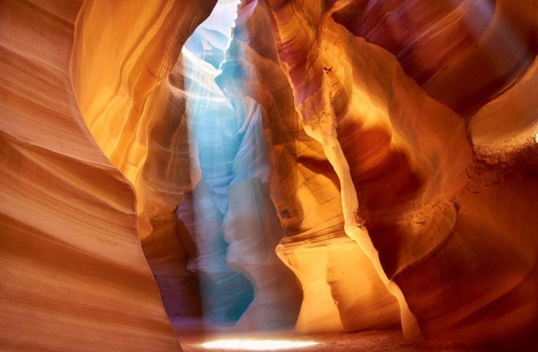
Upper Antelope Canyon: Approximately 660
feet (200 m) long. It has an "A-shaped" cross-section (narrower at the
top, wider at the base in places) with a relatively flat, sandy floor
accessible at ground level—no ladders required for entry. The tall,
smooth walls create iconic "light beams" (shafts of sunlight filtering
through overhead openings, especially midday in summer). This section is
wider and more open in chambers, making it photogenic but often crowded.
Lower Antelope Canyon: About 1,335 feet (407 m) long—roughly twice as
long as the Upper. It features a more "V-shaped" or corkscrew
configuration, with narrower passages and uneven footing. Access
requires descending and ascending metal ladders/stairs (equivalent to
3–5 flights), adding a moderate physical challenge. It has swirling,
wave-like walls but fewer dramatic overhead light beams due to different
light angles.
The entire system is part of a larger ~30-mile
Antelope Canyon Wash drainage. The rock surfaces are polished smooth and
undulating, with swirling striations, curves, and alcoves formed by
abrasive water flow. Colors range from warm oranges, reds, and pinks to
purples and golds, primarily from iron oxide minerals (hematite and
goethite) in the sandstone layers.
Geology and Formation
The
canyons are eroded into Navajo Sandstone, a Jurassic-period
(approximately 190 million years old) sedimentary rock formation
deposited in a vast ancient desert environment as wind-blown sand dunes.
These dunes were later buried, compacted, and cemented into thick,
cross-bedded layers of quartz sandstone—porous yet durable enough to
form steep walls but soft enough for rapid erosion.
The canyon itself
formed much more recently—primarily over the last 5–6 million years
(with some sources citing 8–60 million years for initial incision),
coinciding with the final uplift of the Colorado Plateau. Initial
fractures in the rock arose from tectonic stresses and jointing. Erosion
was driven overwhelmingly by episodic flash flooding:
Monsoon
rains (July–September) collect over a large upstream drainage basin on
the hardpan desert surface.
Water funnels rapidly into narrow
fissures, accelerating and picking up sand, gravel, and debris that act
like sandpaper.
Turbulent flow scours and polishes the walls into
smooth, flowing shapes while deepening the slots.
Secondary processes
include wind abrasion (carrying sand particles) and occasional
sub-aerial weathering.
This ongoing process continues today;
flash floods still reshape the interior during storms. The result is the
signature "slot canyon" morphology: extremely narrow relative to depth,
with intricate, wave-like patterns.
Hydrology, Climate, and
Environmental Aspects
Antelope Canyon experiences a classic arid
high-desert climate (Köppen BWh/BWk): hot summers (daytime highs often
90–100°F/32–38°C, with extreme diurnal swings), mild winters (daytime
40–60°F/4–15°C), and low annual precipitation (~6–10 inches, bimodal
with summer monsoons and winter frontal storms). Vegetation is
sparse—typical Colorado Plateau desert scrub—supporting limited wildlife
(lizards, small mammals, occasional birds).
Hydrologically, the
canyons are highly prone to dangerous flash floods. Even distant
upstream rain can send walls of water rushing through the narrow slots
at high velocity, making guided tours mandatory (Navajo Nation policy)
and weather monitoring essential. Post-1997 flood (which tragically
killed 11 visitors in Lower Antelope), safety infrastructure like
ladders and exit routes was improved.
The canyons are dynamic: floods
continue to erode and smooth surfaces, so the exact formations evolve
slowly over decades. They are protected as part of Lake Powell Navajo
Tribal Park, accessible only via authorized Navajo-guided tours to
preserve the sacred site and ensure safety.
Notable Features and
Variations
Light phenomena: Upper Antelope is famous for midday "God
beams" piercing the narrow openings.
Other sections: Canyon X and
others offer less-crowded alternatives with similar geology but
different access and lighting.
Nearby landmarks: Within minutes are
Horseshoe Bend (Colorado River meander), Glen Canyon Dam, and Rainbow
Bridge (accessible by hike or boat).
Antelope Canyon, located near Page, Arizona, on Navajo Nation land,
ranks among the world’s most iconic slot canyons and serves as a magnet
for photographers, tourists, and business visitors alike. The Navajo
people have managed it as a restricted tribal park since 1997, when
public access to this sacred site officially opened. Its dramatic,
undulating sandstone walls—carved over millennia by flash floods and
wind—create an otherworldly landscape that rewards visitors with
ever-shifting patterns of light and color.
Photographing inside
narrow slot canyons presents unique technical challenges, primarily due
to extreme contrast. The bright beams of sunlight pouring through
openings in the canyon roof can differ from the deep shadows by 10 EV
(or more), a dynamic range that strains even modern cameras. The smooth,
reflective sandstone walls bounce light in complex ways, further
complicating exposure.
Interestingly, many photographs of Antelope
Canyon appear more vibrant and mysterious than the scene the naked eye
perceives in person. Deep blue tones in the shadows, for example, often
emerge vividly in images but are subtly filtered out by the human brain
during a live visit, especially at twilight. This optical phenomenon
gives photos an almost ethereal, otherworldly quality that draws viewers
in.
To capture the canyon’s full beauty, photographers must prepare
for long exposures—often several tens of seconds or more—to achieve a
generous depth of field while keeping noise low. Tripods are essential.
Bracketing (taking multiple shots at different exposures) is a common
technique that helps compensate for metering inaccuracies in such tricky
lighting. By combining several bracketed frames of the same composition
in post-processing software (such as Adobe Lightroom or Photoshop),
photographers can blend the best-exposed highlights, midtones, and
shadows into a single stunning HDR or manually blended image. The result
is often breathtaking, with rich detail throughout the frame.
Best Times to Photograph
The optimal window for photography is
generally midday when the sun sits high overhead, sending dramatic light
shafts deep into the canyon. Timing varies between the two main
sections:
Lower Antelope Canyon: Best photographed before noon or in
early afternoon (roughly 10–11 a.m. or 1–2 p.m.), when angled light
creates beautiful patterns without overwhelming direct sun that can wash
out the magic at exact noon.
Upper Antelope Canyon: Peaks around noon
(11 a.m.–1 p.m.), as this deeper section receives less ambient light
overall.
The Upper Canyon stretches approximately 200 meters (660 feet) in
length and reaches depths of about 37 meters (120 feet). Its Navajo
name, Tse bighanilini, translates to “the place where water runs through
the rocks.” It remains the more popular and frequently visited section
for two practical reasons: the entire length sits at ground level,
requiring no ladders or strenuous climbing, and the famous “light beams”
(crepuscular rays streaming through ceiling openings) are easier to
witness here than in the Lower Canyon.
These ethereal light rays
appear most reliably in summer, when the sun reaches its highest point
in the sky. Winter light tends to be softer and the colors slightly more
muted, while summer offers two distinct photographic moods. Morning and
mid-afternoon tours often yield deep reds, rich oranges, purples, and
intense blues. Direct light beams typically begin appearing around March
15 and fade by October 7, with peak illumination and the most dramatic
effects occurring from May through September.
Whether you visit for a
quick guided tour or a dedicated photography expedition, Antelope Canyon
delivers an unforgettable experience. Its combination of natural
architecture, ever-changing light, and cultural significance makes it
one of the most rewarding—and technically demanding—destinations for
landscape photographers. Proper planning, patience, and post-processing
skill can transform good images into truly mesmerizing ones that capture
the canyon’s unique magic.
Lower Antelope Canyon, known to the Navajo as Hasdeztwazi (“Spiral
Arches of Rock”), lies just a few kilometers downstream from its more
famous sibling, Upper Antelope Canyon. The slot canyon stretches
approximately 407 meters (about 1,335 feet) through striking Navajo
sandstone.
Before the installation of metal ladders and stairs in the
1990s, visitors had to descend and ascend using ropes and precarious
rope ladders in several sections — an extremely dangerous undertaking.
Even today, the hike through Lower Antelope Canyon is considerably more
physically demanding than the Upper Canyon walk. The route is longer,
significantly narrower in places (sometimes only wide enough to squeeze
through sideways), and features several sections where you must crawl,
climb, or navigate tight passages where standing upright is impossible.
At the end of the tour, visitors climb multiple long flights of metal
stairs to exit.
Despite these challenges, Lower Antelope Canyon is
often the stronger draw for serious photographers. Its deeper, more
twisting corridors create dramatic light beams, glowing walls, and
intricate swirling patterns in the rock that many consider even more
photogenic than the Upper Canyon. The best lighting typically occurs in
the early morning (shortly after opening) or late afternoon, when the
sun’s angle sends shafts of golden light deep into the narrow slots,
illuminating the smooth, wave-like sandstone formations.
Antelope Canyon is accessible only with a licensed Navajo guide.
Flash flooding remains a serious risk, especially during the summer
monsoon season (July–September). Even a distant thunderstorm can send a
wall of water rushing through the canyon with little warning. Guides
immediately cancel tours at the first sign of rain or heavy weather
upstream.
A tragic reminder of this danger occurred on August 12,
1997, when a flash flood swept through Lower Antelope Canyon, killing 11
tourists and injuring one survivor. Since then, strict safety protocols
have been enforced, including real-time weather monitoring.
The stunning red-rock formations have appeared in numerous films,
music videos, and advertisements.
Britney Spears filmed the music
video for her 2001 hit “I’m Not a Girl, Not Yet a Woman” in Upper
Antelope Canyon.
The Upper Canyon also featured in the 1996 action
film Broken Arrow, starring Christian Slater and John Travolta.
Its otherworldly beauty continues to make Antelope Canyon one of the
most photographed natural wonders in the American Southwest, drawing
hundreds of thousands of visitors each year.
Upper vs. Lower Antelope Canyon (and Canyon X)
Upper Antelope
Canyon: Wider at the bottom (A-shaped), easier access (mostly flat
with a slight incline), famous for dramatic light beams (especially
midday May–October). More crowded and photogenic but feels less
claustrophobic. Tours last ~1–1.75 hours. Best for families,
beginners, and beam chasers.
Lower Antelope Canyon: Narrower and
deeper (V-shaped), requires descending/ascending steep metal
ladders/stairs (equivalent to 3–4 flights). More adventurous with
tighter passages. Fewer dramatic beams but excellent light, colors,
and fewer crowds. Tours ~45–90 minutes + ladders. Good for those
seeking a physical challenge.
Canyon X (part of Antelope Canyon
system): Less crowded, more affordable alternative with two slot
sections. Longer hikes possible; photography tours available. Ideal
if main sections are booked or you want solitude.
Recommendation: Do Upper for the classic beams/photos, Lower for
adventure, or both if time/budget allows (plan 60–90+ minutes buffer
between tours). Canyon X as a backup or add-on.
Booking and
Costs (2026 Info)
Mandatory: Book in advance through authorized
Navajo tour operators (listed on navajonationparks.org). Tours sell
out weeks to months ahead, especially midday slots in peak season.
Navajo Parks Entry Fee: $15 per person per location (separate but
often bundled; supports preservation).
Tour Prices (approximate,
vary by operator/time/season; plus taxes/fees):
Upper: $80–$150+
(higher for midday beam times).
Lower: $50–$100.
Canyon X:
Often cheapest (~$40–$60 hiking tour).
Book 2–4+ weeks ahead
in shoulder/peak (March–November); 1–2 weeks in winter. Peak demand:
March–May, Sept–Nov. Use official sites or reputable platforms like
Viator for reviews.
Popular operators include Antelope Canyon
Tours (Upper), Ken’s/Dixie Ellis (Lower), and Taadidiin Tours
(Canyon X).
Best Time to Visit
For light beams (Upper):
Midday (roughly 10:30 a.m.–1:30 p.m.), May–August/September. Beams
are strongest in summer.
Fewer crowds/better value:
November–February (especially January). Richer colors, dramatic
light, lower prices, but no/mild beams and cooler temps.
Shoulder
seasons (April/May, Sept/Oct): Good balance of weather, light, and
crowds.
Avoid: Peak summer midday weekends for extreme crowds;
monsoon season (July–Sept) for flash flood risk/possible closures.
Year-round access, but check weather—canyons can close for
rain/snow/floods.
Time zone note: Navajo Nation follows
Arizona time (no DST), so confirm carefully.
Getting There
Base in Page, AZ: Most tours meet in Page (some provide transport)
or at the park entrance. Drive ~8–10 miles east on AZ-98.
No
public transport; rent a car, use taxi/shuttle (~$20–25 one way), or
join a day tour from Las Vegas/Phoenix.
Upper often involves a
short 4WD truck ride through sand wash; Lower is walkable from
parking.
What to Expect on Tour
Groups of ~10–20 with a
Navajo guide who shares geology, culture, and photo tips.
Upper:
Walk through on sand; guides may demonstrate "falling sand" pours.
Lower: Ladders, narrow squeezes, boulders—physically demanding.
Tours move at a steady pace (not always leisurely due to crowds). No
lingering too long in spots.
Duration includes
transport/check-in.
Preparation and What to Bring/Wear
Clothing/Shoes: Sturdy closed-toe shoes (hiking or athletic—sand
gets everywhere). Layers for temp changes. Hat/sunglasses. Contacts?
Switch to glasses (dust).
Essentials: One small water bottle
(take it out with you). Sunscreen. Camera/phone (handheld only—no
tripods, monopods, selfie sticks, or large bags on standard tours).
Prohibited: Bags/purses, food/drinks (beyond water), tripods (unless
photo tour), drones.
Fitness: Upper is easy; Lower requires good
mobility (stairs/ladders). Check operator videos/requirements. Not
recommended for severe mobility issues, very young kids (age
minimums vary), or claustrophobia.
Arrive 15–30 minutes early. No
restrooms/trash in canyon.
Photography Tips
Upper beams:
Midday summer; high ISO, wide aperture, no flash. Look up!
Sand/dust: Cover gear; avoid lens changes.
Handheld only on
standard tours—practice settings beforehand. Guides often help pose
shots.
Lower: More even light, easier for handheld. Canyon X may
allow more time/tripods on photo tours.
Best results in
off-season for colors/contrast without crowds.
Rules and
Respect
Follow guide instructions strictly. Do not touch walls
(oils damage sandstone).
Leave no trace; pack out everything.
Cultural sensitivity: Navajo land—respect traditions and land.
Photography restrictions may apply; no commercial use without
permits.
Nearby Attractions and Itinerary Ideas
Combine
with Horseshoe Bend (sunrise/sunset), Lake Powell, Glen Canyon Dam,
or other slot canyons (Mountain Sheep, Rattlesnake). Full-day tours
from Page often bundle them. Stay overnight in Page for flexibility
(options: hotels, B&Bs, glamping hogans).
Potential Drawbacks
Crowds and rushed feel in peak times.
Cost (can add up for
families).
Weather dependency and dust.
Book early and have
backup plans.