The Bear Paw Battlefield (also known as the Battle of the Bear Paw or
Battle of the Bear's Paw Mountains) is the site of the final engagement
in the Nez Perce War of 1877 and the dramatic end of the Nez Perce
(Nimiipuu) Flight of 1877. It is located along Snake Creek in the Bear
Paw Mountains of north-central Montana, about 16 miles south of Chinook
via County Road 240 (in Blaine County). The Nimiipuu called it C’aynnim
Alikinwaaspa ("Place of the Manure Fire"), referring to the bison-dung
fires used for warmth and cooking in the absence of tipis after earlier
battles.
Today, it is a unit of Nez Perce National Historical
Park (managed by the National Park Service), designated a National
Historic Landmark in 1988 and listed on the National Register of
Historic Places. A self-guided interpretive trail (about 1.25 miles)
with markers winds through the rolling prairie and bluffs where the
five-day battle and siege unfolded. The site feels remote and windswept,
with open grasslands, low hills, and distant mountains—evoking the
isolation and desperation of the final standoff just 40 miles (about 64
km) south of the Canadian border.
Background: The Nez Perce War and the 1,170-Mile Flight
The roots
trace to U.S. treaty violations and forced relocation. The 1855 Treaty
of Walla Walla created a large Nez Perce reservation, but the 1863
"Steal Treaty" reduced it by 90% without consent from all bands.
"Non-treaty" bands, led by figures including Chief Joseph
(Hin-mah-too-yah-lat-kekt, of the Wallowa band), refused to leave
ancestral lands in Oregon and Idaho. Tensions erupted in June 1877 when
young warriors killed settlers, prompting an ill-advised U.S. Army
attack at White Bird Canyon (June 17). The Nimiipuu won decisively and
began their epic flight—about 800 people (including roughly 125–200
warriors), herding over 2,000 horses and carrying what they
could—seeking refuge first with Crow allies in Montana, then with Lakota
leader Sitting Bull in Canada.
Under pursuit by General Oliver Otis
Howard, they fought or evaded U.S. forces in a remarkable 126-day,
1,170–1,300-mile (1,900+ km) journey across Idaho, Montana, Wyoming
(including Yellowstone National Park), and back into Montana. Key
earlier clashes included:
Clearwater (July 11–12)
Big Hole
(August 9, where 60–90 Nimiipuu, many women and children, were killed in
a surprise dawn attack)
Camas Meadows (August 20, where they captured
supplies and slowed pursuit)
Canyon Creek (September 13, a rearguard
action that allowed escape but cost many horses)
Exhausted, short
on supplies, and slowed by the need to rest elders, children, and
horses, the bands turned north toward Canada after Canyon Creek.
Prelude to Bear Paw: The Camp at Snake Creek
By late September, the
Nimiipuu—now down to roughly 700 people—believed they had outpaced
Howard. They camped on September 29 along Snake Creek for rest, hunting
bison, and gathering strength for the final push across the border.
Tipis had been lost earlier, so they used crude lean-tos and bison-dung
fires for warmth. Unbeknownst to them, Howard had dispatched Colonel
Nelson A. Miles from Fort Keogh (near modern Miles City) with ~400–520
troops (elements of the 7th and 2nd Cavalry, 5th Infantry, plus Cheyenne
and Lakota scouts). Miles covered 260 miles in just nine days and
approached undetected.
Leadership was collective: Chief Joseph
managed the camp and non-combatants; Looking Glass was the primary
strategist; White Bird and others (including Ollokot, Joseph's brother)
led warriors; Lean Elk (Poker Joe) had urged speed but yielded to rest
needs.
The Battle and Siege (September 30–October 5, 1877)
September 30 (Day 1 – The Attack): Scouts spotted the camp early. Miles
launched a surprise assault around 9:15 a.m. The 2nd Cavalry veered to
seize the horse herd (critical for escape), capturing most in a running
fight and isolating the Nimiipuu. The 7th Cavalry charged the bluffs
overlooking the camp but was repulsed in fierce hand-to-hand combat by
warriors who rose from concealed positions. The 5th Infantry secured
higher ground to the south but could not advance into the camp. By
nightfall, the Nimiipuu held their defensive positions (a roughly
250-yard square area with rifle pits and shelters dug using camas
sticks, knives, and captured tools). Casualties were heavy: ~22–26
Nimiipuu killed (including chiefs Ollokot, Toohoolhoolzote, and Lean
Elk) and many wounded; U.S. forces suffered ~18–24 dead and 48 wounded
(7th Cavalry hit hardest). Both sides dug in for a siege as snow began
falling.
October 1–2 (Siege Begins): Cold and snow intensified
suffering. Under a truce, Joseph met Miles, but was briefly taken
prisoner as leverage (exchanged for a captured U.S. officer, Lt. Lovell
Jerome, who was treated well in the Nimiipuu camp). Looking Glass was
killed on October 2 by a sniper while scanning the horizon—mistaking
distant figures for potential Sioux allies from Sitting Bull's camp.
October 3–4: Fighting continued sporadically. The Army brought up a
12-pounder Napoleon cannon, shelling the shelter pits and killing at
least one woman and one girl. General Howard arrived with a small escort
on October 4 (his main force had been sent home), but Miles retained
tactical command. The Nimiipuu, low on food, blankets, and hope, faced
freezing conditions and endless U.S. reinforcements.
October 5
(Surrender): Two treaty Nez Perce emissaries entered camp with promises
of safety, food, blankets, and return to Idaho. White Bird refused to
trust the Army and led a group out that night. Joseph, speaking for
those remaining, chose to end the fight. Around 2 p.m., he met Miles and
Howard, handed over his rifle, and delivered his immortal speech
(translated by an interpreter):
"I am tired of fighting. Our chiefs
are killed. Looking Glass is dead. Too-hul-hul-suit is dead. The old men
are all dead. It is the young men who say 'yes' or 'no.' He who led on
the young men [Ollokot] is dead. It is cold, and we have no blankets.
The little children are freezing to death. My people, some of them, have
run away to the hills, and have no blankets, no food. No one knows where
they are—perhaps freezing to death. I want to have time to look for my
children, and see how many of them I can find. Maybe I shall find them
among the dead. Hear me, my chiefs. I am tired. My heart is sick and
sad. From where the sun now stands, I will fight no more forever."
Approximately 400–431 Nimiipuu (79 men, 178 women, 174 children)
surrendered. Total U.S. casualties for the battle: ~24 dead, 49 wounded.
Nimiipuu losses: ~23–30 killed in combat (plus women/children), ~46
wounded.
Aftermath and Legacy
Miles promised the Nimiipuu
could return to Idaho, but superiors overruled him. The captives endured
a brutal journey: first to Fort Keogh, then North Dakota, Kansas (Fort
Leavenworth), and finally Indian Territory (Oklahoma), where disease and
harsh conditions killed many. Chief Joseph and others lobbied for eight
years; in 1885, some returned to Idaho, while Joseph and ~150 went to
the Colville Reservation in Washington. Those who escaped with White
Bird (~200–300 total over the flight) reached Canada but faced ongoing
hardship.
The Bear Paw Battlefield symbolizes Nimiipuu resilience,
strategic brilliance, and the human cost of U.S. expansion. It is the
final stop on the Nez Perce National Historic Trail. The site remains
sacred; visitors often describe a profound sense of solemnity amid the
quiet prairie. Exhibits at the Blaine County Museum in Chinook provide
artifacts, multimedia, and context.
The Bear Paw Battlefield (also known as the Bear Paw Battle site or
C’aynnim Alikinwaaspa, "Place of the Manure Fire" in Nez Perce/Nimíipuu)
is a National Historic Landmark within Nez Perce National Historical
Park in north-central Montana's Blaine County. It marks the site of the
final battle and siege of the Nez Perce Flight of 1877, located
approximately 40 miles (64 km) south of the Canadian border and just 16
miles (26 km) south of the town of Chinook along Montana Route 240
(Cleveland Road).
Precise coordinates are 48°22'40.35"N,
109°12'48.07"W (approximately 48.3775°N, 109.2072°W). The site sits in
the open, moderately rolling prairie country of the northern Great
Plains, specifically in the northern foothills of the Bear Paw (or Bears
Paw) Mountains—an isolated "island" mountain range that rises
dramatically from the surrounding plains.
Regional Setting and
Geology
The Bear Paw Mountains form an arcuate, insular-montane range
about 45 miles long, located roughly 10 miles south of Havre and east of
Big Sandy. They are part of the Central Montana Alkalic Province and
originated from Eocene igneous activity (roughly 54–50 million years
ago), involving volcanic fields, shallow intrusions (laccoliths,
stocks), and flows that uplifted and intruded Late Cretaceous
sedimentary rocks. The highest peak, Baldy Mountain, reaches 6,916 feet
(2,108 m), rising about 4,200 feet (1,280 m) above the surrounding
plains.
The battlefield itself lies north of the main range core, on
the lower northern slopes and adjacent plains. Regional bedrock includes
Cretaceous formations like the Bearpaw Shale (a dark-gray marine shale
for which the mountains are named), but the immediate site features
glacial and alluvial deposits overlying these. Pleistocene glaciation
and outwash have shaped the broader terrain, creating subdued
bench-and-tableland topography with terraces along drainages.
Local Topography and Landforms
The battlefield occupies a subtle but
strategically significant landscape of two primary topographic features
along Snake Creek:
The Nez Perce camp area was on a relatively level
primary terrace (floodplain) of Snake Creek—a shallow, crescent-shaped
valley that offered some protection and access to water and game.
The
surrounding prairie surface (where most U.S. Army positions were
established) lies 20–40 feet (6–12 m) higher than the terrace. This
prairie edge is dissected by several ephemeral drainages, coulees (deep
ravines), and gullies trending eastward and southeastward toward the
creek. These features provided natural cover, rifle pits, and routes for
movement or escape.
High bluffs and terraces dominate the valley
margins, while the overall terrain consists of rolling prairie broken by
low hills, shallow valleys, and intermittent drainages. Elevation at the
site is approximately 2,986–3,038 feet (910–926 m) above sea level, with
the 1.8-mile interpretive loop trail gaining only about 121 feet (37 m)
of gentle relief—making it easy to moderate but fully exposed.
The
landscape remains remarkably similar to its 1877 appearance: vast, open
grasslands with sparse trees, distant views of the Bear Paw Mountains to
the south, and subtle undulations that concealed or revealed positions
during the battle.
Hydrology
Snake Creek, a perennial or
semi-perennial stream in this region, was a key attraction for the Nez
Perce encampment due to its fresh water and associated game. The site
features the creek's primary terrace plus multiple ephemeral (seasonal)
drainages and an intermittent north-south trending creek east of some
battlefield features. These coulees and ravines drain
eastward/southeastward into Snake Creek and could channel water during
rains or snowmelt but are often dry. The broader area includes lower
terraces and floodplains typical of prairie drainages.
Climate
and Weather Patterns
The site experiences a semi-arid continental
climate (Köppen BSk) typical of north-central Montana's high plains:
cold winters, warm summers, low precipitation (around 10–15 inches/25–38
cm annually), and frequent strong winds. Summers can be hot and dry
(requiring sun protection and water for visitors), while early fall—when
the 1877 battle occurred—can bring sudden cold snaps, snow, and freezing
conditions (as happened on October 1, 1877, with snow on the ground and
ice in water buckets). The open prairie offers no natural shelter from
wind, sun, or storms.
Soils, Vegetation, and Wildlife
Soils
are primarily well-drained prairie types formed in till or outwash,
often with calcification (calcium carbonate deposits). Vegetation is
classic Montana grassland: dense native grasses forming a thick mat,
with common species including sagebrush, Plains Prickly Pear Cactus,
willow (especially near water), Rough Horsetail, and Prairie Rose. Trees
are rare, and the area is largely treeless except along drainages.
Wildlife includes pronghorn, mule and whitetail deer, badger, fox,
hawks, pheasants, and smaller mammals. Visitors should watch for
rattlesnakes and ticks, especially in warmer months.
Current
Landscape and Access
Today, the site is preserved as open prairie
with a 1.25–1.8-mile self-guided loop trail featuring interpretive
signs, memorials (including to Chief Joseph), a picnic shelter, and
vault toilets. It is surrounded by grassland and some nearby farmland
but retains a remote, reflective quality. No overnight camping is
allowed. The landscape is windswept and expansive, offering panoramic
views ideal for understanding the tactical and environmental challenges
of the battle.
Bear Paw Battlefield (also called Bear Paw Battle Site) is part of
Nez Perce National Historical Park in north-central Montana. It marks
the final battle and surrender site of the Nez Perce (Nimiipuu) Flight
of 1877, a profound and tragic chapter in American history.
After an
1,100-mile trek pursued by the U.S. Army, roughly 800 Nez Perce
people—men, women, and children—were just 40 miles from the Canadian
border when Colonel Nelson A. Miles' forces attacked on September 30,
1877. A five-day battle and siege followed in harsh conditions. On
October 5, Chief Joseph surrendered with the famous words: “From where
the sun now stands, I will fight no more forever.” Many Nez Perce
escaped to Canada, but others faced exile. The entire site is treated as
sacred ground due to unknown burial locations.
Getting There
Location: On Route 240 (Cleveland Road), about 16 miles south of
Chinook, Montana. The paved road leads directly to the site.
Coordinates: approx. 48°22'40"N 109°12'48"W.
From major routes:
From I-15 at Shelby: US Hwy 2 east ~123 miles to Chinook, then south on
Rt. 240 for 16 miles.
From Great Falls: Hwy 87 northeast to Havre,
then US 2 east to Chinook, then south.
From Malta: US 2 west to
Chinook, then south.
Nearby airports: Great Falls (GTF, ~155
miles southwest) is the closest major option. Amtrak in Havre (~38 miles
northwest). No public transit to the site—rent a car.
Road
conditions: Paved access, but check Montana DOT for updates (especially
winter). No plowing or maintenance on site roads/trails in winter.
Pro tip: Stop first at the Blaine County Museum in Chinook (501
Indiana St.). It serves as the de facto visitor center with artifacts, a
20-minute multimedia presentation “Forty Miles from Freedom,” exhibits,
Junior Ranger booklets, and passport stamps. Open varying hours (longer
in summer).
Operating Hours and Seasons
Open daily from
sunrise to sunset, year-round. No entrance fee.
Best time to visit:
Late spring through early fall (May–September) for milder weather and
possible ranger programs. Summer can be hot; shoulder seasons
(spring/fall) offer fewer crowds and evocative conditions similar to the
battle (cooler, windier). Winter visits are possible but challenging due
to snow and lack of maintenance—roads/trails may be impassable.
Ranger-guided tours: Available in summer (often Wednesdays–Sundays or
Tuesdays–Saturdays, mornings only; rangers typically leave by 1 PM).
Call ahead: (406) 357-3130 or (406) 203-8259. No tours in winter.
Self-guided options always available.
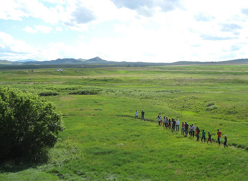
What to Expect and Do
1.25-mile interpretive loop trail: Moderate difficulty with some hills.
Features wayside exhibits, markers, and signs detailing the battle. It’s
a peaceful, reflective walk through rolling prairie/grasslands with
Snake Creek nearby. Allow 45–90 minutes. Brochures/maps available
on-site, at the museum, or downloadable from NPS.
Picnic shelter and
tables: Good for a quiet lunch (bring your own food—no services nearby).
Amenities: Limited—vault toilet (often closed or seasonal; use
facilities in Chinook). Parking for cars/RVs. No visitor center or staff
on-site regularly.
Atmosphere: Remote, open prairie with big skies.
Many visitors describe it as somber, educational, and moving.
Tributes/offerings left by Nez Perce descendants are common—do not
disturb them.
Essential Visiting Tips
Preparation is key
(prairie exposure):
Bring plenty of water, sun protection (hat,
sunscreen, sunglasses), insect repellent (ticks, mosquitoes possible),
and layers for wind/cooler temps.
Sturdy walking shoes for the trail
(gravel, grass, some uneven ground).
Binoculars for wildlife viewing
(hawks, deer, pronghorn, pheasants, etc.). Watch for rattlesnakes and
prickly pear cactus.
Respect the site: Stay on trails (sacred
ground—exact graves unknown). No food/drinks except in picnic area. No
overnight camping. Site closes after dark. Report issues to NPS.
Weather and safety: Exposed to elements—hot summers, thunderstorms,
cold/windy springs/falls, heavy snow in winter. Check forecasts. No
shade on much of the trail.
Accessibility: Trail is groomed but not
fully ADA; moderate with hills. Limited facilities.
Combine with
other sites: Part of the Nez Perce National Historic Trail. Visit Big
Hole or Canyon Creek battlefields, or follow auto tours for broader
context.
Photography/quiet reflection: Excellent for thoughtful
visits. Bring a camera or journal.