Location: 75 mi (120 km) Southeast of Lake Tahoe Map
Found: 1859
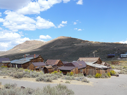
Bodie, California, is one of the most iconic and well-preserved ghost towns in the United States, located in Mono County, about 13 miles east of U.S. Route 395, near the Nevada border. Situated at an elevation of 8,379 feet in the Bodie Hills, this former gold-mining boomtown, now a California State Historic Park, captures the essence of the Wild West. Once home to 8,000–10,000 people at its peak in 1879–1880, Bodie is preserved in a state of “arrested decay,” with roughly 110 structures—about 5% of its original buildings—still standing, their interiors left as they were when residents abandoned them. Designated a National Historic Landmark in 1961 and managed by the Bodie Foundation under the California State Parks system, Bodie attracts over 200,000 visitors annually to its weathered streets, offering a haunting glimpse into a raucous past marked by gold fever, violence, and eventual decline.
Bodie, California, is one of the best-preserved ghost towns in the
American West and a quintessential symbol of the California Gold
Rush era’s boom-and-bust cycle. Located in the Bodie Hills of Mono
County at an elevation of about 8,379 feet (2,554 m) east of the
Sierra Nevada, the town sits in a harsh, windswept high-desert
environment with extreme temperatures, heavy snowfall, and no nearby
timber—factors that shaped its development and eventual decline.
Today, Bodie State Historic Park preserves it in a state of
“arrested decay,” meaning buildings and artifacts are maintained as
they were left behind, without restoration, giving visitors a
hauntingly authentic glimpse into late-19th-century mining life.
Approximately 110 structures remain from an original 2,000, and the
site draws around 200,000 visitors annually.
Discovery and
Early Years (1859–1875)
The story of Bodie begins in the summer
of 1859 when a small group of prospectors, including W. S. Bodey
(also spelled Body, Bodey, or variations of his first name as
William, Waterman, or Wakeman), discovered gold in the hills north
of Mono Lake while exploring the Eastern Sierra foothills. Bodey,
originally from Poughkeepsie, New York, had arrived in California
during the 1849 Gold Rush. He and his companions staked a claim near
what became known as Bodie Bluff and built a rudimentary cabin by
Pearson Spring.
Tragically, Bodey never lived to see the town
that would bear his name (with a spelling change possibly due to a
sign painter in nearby Aurora). In the winter of 1859–1860, he died
in a blizzard while returning from a supply trip to Monoville. His
body was found the following spring, and the mining district was
formally organized in 1860 in his honor. A small stamp mill was
built in 1861, and the Bodie Mining District was established, but
growth was slow. For nearly two decades, Bodie remained a modest
camp of fewer than 20 buildings and a handful of miners. Placer gold
was present, but water scarcity and limited rich deposits kept it
insignificant compared to nearby strikes like Aurora or the Comstock
Lode.
The Boom: From Mining Camp to Wild West Boomtown
(1876–1880s)
Bodie’s transformation began in 1876 when the
Standard Company uncovered a profitable vein of gold-bearing ore. A
major cave-in in 1875 had already hinted at riches, but the
1876–1877 discoveries by the Standard Mine (and the adjacent Bodie
Mine in 1878) sparked a full-scale rush. The mine was purchased and
developed by the Standard Company in 1877, drawing thousands of
hopeful miners, families, merchants, and opportunists. By 1879, the
population exploded to an estimated 7,000–10,000 people (with some
accounts citing up to 10,000), supported by around 2,000
structures—including homes, stores, hotels, a Wells Fargo bank, four
volunteer fire companies, a jail, churches, schools, newspapers, and
a mortuary. Main Street stretched over a mile.
At its peak around
1879–1880, Bodie was briefly one of California’s largest cities
(though U.S. Census data places the 1880 population at 5,417). It
featured 30+ gold mines, nine stamp mills, 65 saloons, gambling
halls, brothels, opium dens, and a Chinatown with hundreds of
Chinese residents, including a Taoist temple. The town earned a
notorious reputation as a lawless “Wild West” outpost. Newspapers
frequently reported violence, shootings, and brawls, leading to the
phrase “Bad Man from Bodie” to describe its rough inhabitants. A
popular (if apocryphal) anecdote involves a young girl moving from
San Francisco who wrote in her diary something like “Good, by God,
I’m going to Bodie” or “Goodbye God, I’m going to Bodie,” capturing
the town’s infamous character.
Mining output was substantial:
between 1876 and 1941, the district produced an estimated $34
million in gold and silver (roughly $85–$100+ million in modern
adjusted dollars), with the peak in 1879–1881. Ore was processed in
stamp mills; bullion was shipped under armed guard to Carson City or
San Francisco. Infrastructure improved with a telegraph line (1877),
daily newspapers (starting with The Standard Pioneer Journal in
1877), and the Bodie Railway & Lumber Company narrow-gauge line in
1881 (which hauled lumber and timber from Mono Mills south of Mono
Lake, though it never fully connected as planned). Innovations
included one of the earliest long-distance hydroelectric
transmissions in the U.S. (1892), powering the Standard Mill from a
plant at Dynamo Pond 13 miles away.
Daily life mixed hardship and
opportunity. The high altitude and harsh climate (frequent sub-zero
winters, high winds, and an average of 93 inches of snow) made
living difficult—lumber had to be imported for heating and building.
Families arrived by the 1880s, bringing churches (Methodist and
Catholic) and schools. Yet the red-light district, saloons, and
gambling dens thrived. Labor was unionized through the Miners’ Union
Hall (now a museum), and events like dances and plays provided
entertainment. Notable figures included James S. Cain, who later
played a key role in later revivals, and legends like prostitute
Rosa May, whose story of nursing during an epidemic persists in
local lore.
Decline and Bust (1880s–1942)
The boom was
short-lived. By 1881, richer surface ores were depleted, and
production declined sharply. Miners drifted to newer strikes
elsewhere (e.g., Tombstone, Arizona, or Butte, Montana). Population
plummeted: 779 by 1890, around 698 in 1910, and just 110 by 1920. A
cyanide process in the 1890s briefly revived low-grade ore
processing, and electricity helped efficiency, but the town never
regained its glory. Two devastating fires accelerated the decline—a
major one in the business district in 1892 and another in 1932 that
destroyed much of what remained.
Mining continued on a smaller
scale into the 20th century. James S. Cain bought up claims and
reopened the Standard mill around 1915, generating profits for
former employees. The Great Depression and Prohibition further
reduced activity. Mining officially ended in 1942 when the War
Production Board’s Order L-208 halted non-essential gold mining
during World War II. The last residents left shortly after, though a
few caretakers (like Martin Gianettoni) stayed to protect the site
from vandalism.
Preservation and Legacy (1962–Present)
In
the mid-20th century, Bodie faced threats from looting (nearby towns
like Aurora were stripped bare). The Cain family and later
caretakers safeguarded it. Designated a National Historic Landmark
District in 1961 and California State Historic Park in 1962, Bodie
is now protected by California State Parks (with support from the
Bodie Foundation). The policy of “arrested decay” ensures it looks
much as it did when abandoned—shelves still stocked, furniture in
place, but weathered by time and the elements. It remains a powerful
reminder of the fleeting nature of mining wealth.
Geologically,
Bodie’s riches stemmed from epithermal gold-silver deposits formed
millions of years ago, but historically, the town’s isolation and
climate sealed its fate as a ghost town. Today, visitors can walk
the dusty streets, peer into preserved buildings like the Miners’
Union Hall, schoolhouse, and Standard Mill ruins, and imagine the
raucous life that once filled this high-altitude outpost. Bodie
stands not just as a historic site but as a poignant chapter in the
American West’s story of ambition, hardship, and abandonment.
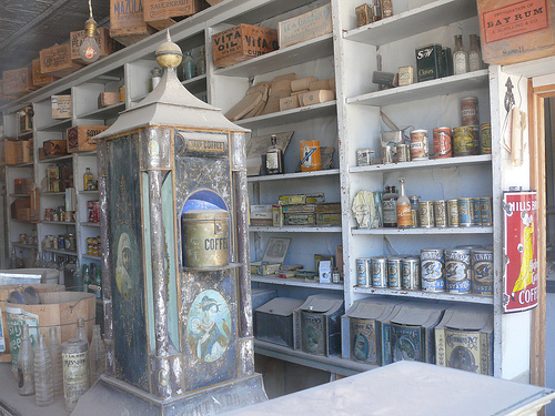
Bodie General store
Location and Regional Context
Bodie lies at approximately 38.212°
N, 119.012° W, about 8,379 feet (2,554 m) above sea level in a broad,
high valley or basin within the Bodie Hills. It sits roughly 75 miles
(121 km) southeast of Lake Tahoe and 12 miles (19 km) east-southeast of
Bridgeport (the nearest town with services). Access is via State Route
270, which branches east from U.S. Highway 395; the final 3 miles are a
rough, unpaved dirt road that can be impassable in winter due to snow.
The Bodie Hills form a low, roughly 40-by-30 km volcanic mountain range
straddling the California-Nevada border (continuing as the Bodie
Mountains in Nevada). Potato Peak, the highest point in the range at
10,220 feet (3,115 m), rises about 1,800 feet above the town. The area
is separated from the much higher Sierra Nevada (which tower nearly
2,000 m above nearby valleys like Bridgeport Valley and Mono Basin) by
the low-lying Mono Basin to the southwest. To the north lie the
Sweetwater Mountains, creating a ring of peaks around the high plateau
where Bodie sits.
This positioning places Bodie in an exposed,
windswept high-desert plateau with relatively gentle relief compared to
the Sierra but dramatic volcanic topography.
Topography and
Landforms
The immediate landscape around Bodie is a mix of rolling
hills, volcanic domes, ridges, and broad valleys. Local elevations in
the Bodie area range from about 8,100–9,200 feet (2,470–2,800 m), with
steeper slopes and craggy outcrops on nearby peaks and bluffs (e.g.,
Bodie Bluff at ~9,000 ft and Bodie Mountain nearby at over 10,000 ft).
The town itself occupies a relatively flat meadow-like basin surrounded
by sagebrush-covered slopes and rocky knobs.
Volcanic landforms
dominate: composite volcanoes, lava domes, flows, and tuff deposits from
ancient eruptions create a rugged, undulating terrain. Primary features
include subcircular volcanic centers and dome fields. Quaternary
surficial deposits (colluvium, alluvium, and some glacial/lacustrine
materials) mantle lower areas. The overall feel is open and exposed,
with little natural shelter from winds due to the plateau-like setting
and sparse vegetation.
Geology
The Bodie Hills are underlain
primarily by the middle-to-late Miocene Bodie Hills volcanic field and
the younger Pliocene-to-Pleistocene Aurora volcanic field. These consist
of intermediate-to-silicic lavas (trachyandesite, trachydacite,
rhyolite), domes, and ash-flow tuffs. Hydrothermal systems associated
with this magmatism created extensive alteration zones rich in gold and
silver—the reason for Bodie’s 19th-century mining boom.
Tectonically,
the area lies near the western edge of the Walker Lane (a zone of
right-lateral shear) and the Basin and Range Province, at the northwest
limit of the Mina deflection. Rocks are only gently tilted, preserving
original volcanic features well. Sedimentary basin-fill deposits
(gravels, fanglomerates) lap onto the volcanic highs on the margins.
This geology not only shaped the rugged topography but also produced the
mineral wealth that briefly made Bodie one of California’s richest gold
districts.
Climate
Bodie has a rare dry-summer subarctic
climate (Köppen Dsc) at this latitude, driven by its high elevation and
exposed position. Summers are warm but short (daytime highs in the
70s–80s °F / 21–27 °C), with nights that can drop near or below freezing
even in July (average July low ~35 °F / 2 °C). Large diurnal swings are
common—up to 43 °F (24 °C) in August.
Winters are long, cold, and
snowy: January averages around 42 °F high / 6–9 °F low, with extremes
well below zero. Annual precipitation averages 12–13 inches (305–330
mm), mostly as snow (annual snowfall ~95–100 inches / 240–254 cm). Snow
can fall any month, with 3–6 feet common on the ground and drifts up to
20 feet. High winds are frequent due to the unsheltered plateau. It is
in USDA Hardiness Zone 5, with no freeze-free month on record.
These
conditions create a harsh, high-desert environment with rapid weather
changes—visitors are advised to prepare for temperature drops, wind, and
altitude effects.
Hydrology and Water Features
Bodie sits in a
relatively dry basin with no major perennial rivers flowing through the
townsite. Nearby features include small springs (e.g., historic Pearson
Spring) and ephemeral streams. Within the broader Bodie Hills are two
streams—Rough Creek and Atastra Creek—deemed eligible for Wild and
Scenic River status, plus riparian zones, small wet meadows, and aspen
groves that provide localized oases.
The area drains toward the Mono
Basin and East Walker River systems. Groundwater and surface water were
historically important for mining but are limited, contributing to the
arid character.
Vegetation and Broader Ecological Geography
The Bodie Hills form a biodiversity hotspot in the Great Basin
ecoregion, acting as a transition between Sierra Nevada conifer forests
and sagebrush steppe. Vegetation includes sagebrush, pinyon pine,
lodgepole pine, Sierra juniper, and Utah juniper, with alpine meadows
and riparian patches higher up. The high-desert terrain supports species
like Bi-State sage grouse, pronghorn, pika, and mule deer.
Bodie State Historic Park, established in 1962 after failed private
preservation efforts, maintains the town in “arrested decay,”
stabilizing structures without restoring them. About 110 buildings
remain, including homes, a school, a church, a jail, the Miners Union
Hall, the Standard Mill, a firehouse, a morgue, and the Odd Fellows
Lodge. Interiors are frozen in time, with dusty furniture, canned goods,
and personal items left behind, protected by the Bodie Foundation’s
rangers. The Standard Mill, a key attraction, offers guided tours ($15,
summer only) showcasing stamp mills and cyanide vats used to process
gold ore. The cemetery, on a hill outside town, holds graves of miners,
children, and outlaws, with some markers lost to time.
Preservation is a constant battle against harsh weather and vandalism.
Rangers live on-site year-round, and the Bodie Foundation funds repairs
through donations and tours. Visitors can explore open areas but are
barred from entering roped-off buildings due to safety risks. Theft of
artifacts, once rampant, has declined with stricter enforcement, but the
“Bodie Curse” legend—misfortune befalling those who take items—deters
pilfering. The park’s remote location and lack of commercial development
enhance its authenticity, making it a photographer’s paradise,
especially during “Bodie Photographers Days” with extended access.
Bodie State Historic Park (often just called Bodie) is a remote,
preserved-in-"arrested-decay" ghost town and California state park at
about 8,375 feet elevation in the Bodie Hills of the Eastern Sierra
Nevada, Mono County. It sits roughly 13 miles east of U.S. Highway 395
in central California, northeast of Yosemite National Park and near
Bridgeport, Lee Vining, and Mono Lake.
There are no public buses,
shuttles, or regular transit to Bodie—driving is the only practical way
to get there for most visitors. The park is open year-round for day use
(no camping or lodging on-site), but access depends heavily on weather
and road conditions. The main route is straightforward for most
passenger vehicles in dry conditions, but the final stretch is a rough
dirt road that requires caution.
Primary Route: Via State Route
270 (Bodie Road / "The Bodie Road")
This is the easiest and most
recommended route for standard cars, SUVs, and even some RVs (with
care). It is well-signed from U.S. 395.
Drive north or south on U.S.
Highway 395 until you reach the signed turnoff for Bodie State Historic
Park / State Route 270.
Turn east onto SR 270.
From Bridgeport, CA
(closest town with services): Drive ~6–7 miles south on U.S. 395, then
turn left (east) onto SR 270. The drive from the turnoff takes about 45
minutes.
From Lee Vining, CA / Mono Lake / Yosemite East Entrance:
Drive ~18–20 miles north on U.S. 395, then turn right (east) onto SR
270. Also about 45 minutes from the turnoff.
Drive 10 miles of
paved road (two-lane highway climbing gently into the hills).
The
pavement ends, and you continue on 3 miles of unsurfaced dirt/gravel
road (often washboarded and dusty). Speed limit is 15 mph here—drive
slowly to avoid damage and dust clouds. Reduced speeds are mandatory;
the road can be bumpy but is generally passable by most two-wheel-drive
vehicles in dry summer/fall conditions.
Total distance on SR 270:
13 miles.
Total drive time from highway: ~45 minutes (plan extra time
for photos, dust, or cautious driving).
As you crest the last hill on
the dirt road, the ghost town suddenly appears below you—an
unforgettable view. Park in the designated lot (ample space but fills on
busy summer weekends). An entrance kiosk or self-pay station is right
there (cash preferred; credit cards accepted at the kiosk).
Alternative Routes (Use Only if Experienced / With Proper Vehicle)
These are not recommended for standard cars or first-time visitors:
Cottonwood Canyon Road (from Lee Vining area): Take U.S. 395 north, turn
right on CA-167 east, then left on Conway Ranch Road, right on Goat
Ranch Cutoff, and follow Cottonwood Canyon Road. ~45 minutes from Lee
Vining. This is a dirt road that can be muddy or snowy in winter/spring
and may be closed by the county.
Aurora Canyon Road / Masonic Road
(from Bridgeport): East on U.S. 395, then CA-182 north briefly, right
onto Aurora Canyon Road (becomes dirt after the cemetery). ~20 miles / 1
hour. Requires four-wheel-drive and high-clearance vehicle; not advised
in winter or muddy spring conditions.
Luck Boy Pass / Aurora Road
(via Hawthorne, NV): Not maintained and currently impassable due to past
storm damage.
Driving from Major Cities or Airports (Approximate)
Mammoth Lakes → ~1–1.5 hours (35 miles north on 395 to turnoff + 13
miles on 270).
Reno, NV → ~2.5–3 hours (south on 395).
South Lake
Tahoe → ~2–2.5 hours (via 395).
San Francisco Bay Area → 6–8 hours
(via I-80 to 395 or through Yosemite if open).
Los Angeles → 7–9
hours (via 395 north).
Nearest airports:
Mammoth Yosemite Airport
(MMH) — ~63 miles / 1.5 hours drive.
Reno-Tahoe International (RNO) —
~2.5–3 hours drive.
Bishop (BIH) — longer drive south on 395.
Rent
a car at the airport—there is no public transport to Bodie.
Use
Google Maps, Waze, or Apple Maps with “Bodie State Historic Park” as the
destination—it routes you correctly via SR 270.
Road Conditions,
Vehicle Tips & Seasonal Access
Dry conditions (late spring through
fall): Most 2WD cars are fine. The dirt section is often dusty—keep
windows up and use recirculate AC.
Wet/muddy conditions: Can become
slippery or rutted; high-clearance or 4WD is safer. Spring mud is a
common issue.
Winter (typically Nov–May): SR 270 is not plowed and
closes when snow accumulates. Bodie becomes accessible only by
snowmobile (stay on designated roads), cross-country skis, or snowshoes.
Sub-zero temps, high winds, and whiteouts are common. Many 4WD vehicles
with chains still get stuck.
Always check before you go:
Caltrans
Road Conditions: roads.dot.ca.gov (search for Hwy 270 or 395).
Mono
County weather/roads:
monocounty.org/plan-your-trip/weather-and-road-conditions.
Park phone
(for specific dirt-road status): (760) 616-5040.
Vehicle prep:
Full tank of gas (no fuel at Bodie—fill in Bridgeport or Lee Vining).
Spare tire, jack, and basic tools.
Water, snacks, sunscreen, hat,
layers (weather changes fast at elevation).
Download offline
maps—cell service is spotty to nonexistent.
Practical Tips Once
You’re on the Road
Drive time buffer: The dirt road is slower than it
looks; allow extra time.
Parking & crowds: Arrive early in summer;
the lot can fill.
No services: Bring everything you need—food, water,
fuel. Restrooms (flush toilets) are available at the parking/picnic
area.
Best time: Late spring through early fall for easiest access
and longer daylight. Summer days are warm but can be windy; nights are
cold.
Dogs: Allowed on leash but not in the museum or on certain
tours.
Bodie is a day-use-only site—plan 3–5 hours to explore on
foot. The drive itself is part of the adventure: high-desert scenery,
sagebrush, distant Sierra views, and that dramatic final descent into
the ghost town.
Bodie encapsulates the boom-and-bust cycle of the American West. Its
rapid rise, fueled by gold, attracted a diverse population, including
Chinese laborers (who lived in a segregated Chinatown), African
Americans, and European immigrants. The town’s lawlessness—exemplified
by figures like Waterman S. Body (Bodey) and tales of “Bad Men of
Bodie”—contrasted with its community spirit, seen in schools and
churches. The 1880s diphtheria epidemic and fires of 1892 and 1932
highlight the fragility of such towns, while the cemetery, with graves
like that of Rosa May, a prostitute buried outside the fence, reflects
social hierarchies.
Bodie’s preservation as a ghost town is
unmatched, offering a raw, unpolished view of history unlike restored
sites like Virginia City, Nevada. Its designation as a National Historic
Landmark and California’s Official Gold Rush Ghost Town (since 2002)
underscores its importance. The Bodie Foundation’s work ensures that
stories of miners, families, and outcasts endure, while Native American
perspectives—particularly the Mono Lake Paiute, displaced by mining—add
complexity to the narrative, though less documented.
Bodie State Historic Park is one of California's most authentic and
best-preserved ghost towns, maintained in a state of "arrested decay"
(only minimal stabilization to prevent collapse, with everything left as
it was when the last residents departed decades ago).
At an elevation
of 8,375 feet in the Bodie Hills of Mono County (northeast of Yosemite,
east of US 395), it offers a haunting glimpse into the Wild West
gold-mining era. In its 1870s–1880s boom, Bodie had up to ~8,000–10,000
residents, ~2,000 structures, saloons, a church, school, jail, and
brothels. It produced millions in gold and silver but declined sharply
after 1881, with mining ending in 1942. Fires in 1892 and 1932 destroyed
much of it; today, about 200 buildings remain, many with interiors
frozen in time (peeking through windows is the norm).
Getting
There
The standard route is from US 395, about 7 miles south of
Bridgeport: Take State Route 270 east for 10 miles of paved road, then 3
miles of dirt/gravel road (often washboarded or rough; drive slowly at
15 mph). The last stretch can be dusty, bumpy, or muddy in
spring—suitable for most passenger vehicles in good conditions, but
high-clearance or 4WD is safer in bad weather.
Alternative routes
(e.g., Cottonwood Canyon Road from near Mono Lake/Lee Vining) are more
scenic but often rougher and longer. Other back roads may require 4WD.
Check conditions before heading out: Use Caltrans (SR 270), the park
website, or call (760) 616-5040. The road closes with heavy snow
(typically Nov–May); winter access is by snowmobile, skis, or snowshoes
only. Towing is expensive and unreliable in remote areas.
Cell
service is limited or nonexistent. Fuel up in Bridgeport or Lee Vining
(no gas in Bodie). Allow 30–60+ minutes from nearby towns.
Hours,
Fees, and Best Time to Visit
Summer (roughly Memorial Day–Labor Day,
or March–Oct variations): 9 AM–6 PM.
Winter (Nov–May-ish): 9 AM–4 PM
(weather permitting; road often closed).
Fees (per person,
day-use only; subject to change): Adults $8, children 4–17 $5, under 3
free. Pay at staffed kiosk (cash/credit in season) or self-pay envelope
(cash) in parking lot. California Explorer passes generally not
accepted, but Historian Passport is.
Best time: Late spring through
early fall (June–mid-October) for reliable road access, longer hours,
and milder weather. Peak crowds are June–August. Shoulder seasons
(spring/fall) offer fewer people and good light for photos. Avoid winter
unless prepared for snow and limited access.
Plan for 1–3 hours (at
least 2 for a good exploration). Arrive early to avoid crowds and have
time before closing.
What to Expect and Bring
No commercial
services (no food, gas, or lodging). Bring everything you need: water,
snacks/picnic (picnic areas available), sunscreen, hat, sunglasses,
layers (temperatures swing wildly; nights can be cold even in summer),
sturdy closed-toe hiking shoes/sneakers for uneven, dusty terrain with
hills.
High altitude means easier dehydration, fatigue, or altitude
sickness—drink water, go slow, and rest. Bugs possible in spring;
rattlesnakes rare but possible. Restrooms (flush toilets and outhouses)
are near parking/picnic areas and in town.
Photography: Excellent
opportunities (buildings, relics, landscapes). Self-guided; no drones
allowed. Professional/commercial shoots need permits. Special night
photography or after-hours access via Bodie Foundation workshops
(limited, paid).
Rules and Etiquette
Leave everything as found
— Nothing may be taken (artifacts, rocks, plants, etc.). This is
strictly enforced; it's a giant outdoor museum. Do not move items or use
metal detectors. Violators can face fines.
Stay on paths/out of
closed/unstable areas (posted for safety).
Dogs allowed on leash
(clean up after them); not in museum or on some tours.
No camping.
Smoking only in parking lot.
Respect the "arrested decay" — minimal
modern interference.
Enhancing Your Visit
Buy the $3
self-guided tour booklet (map + building histories) at the kiosk,
museum, or path—highly recommended.
Visit the small
museum/bookstore/gift shop (seasonal) in the Miners' Union Hall for
exhibits, a short video, souvenirs (proceeds help preservation), and
tour info.
Guided options (seasonal, May–Oct): Free history talks;
paid Stamp Mill tours (~$6, inside the big mill on the hill—worth it);
occasional ghost walks, twilight tours, or special events (check Bodie
Foundation).
Cemetery is worth a short walk (self-guided booklet
available).
Safety and Practical Tips
Weather can change fast
(afternoon thunderstorms, wind, sudden cold). Check forecasts.
High
UV at altitude — protect skin/eyes.
Drive cautiously on dirt road;
watch for dust clouds from others.
Limited parking — arrives early in
peak season.
Nearest lodging/food in Bridgeport (~30–45 min) or Lee
Vining.
For families: Kid-friendly with Junior Ranger activities;
engaging for all ages but supervise closely around ruins.