Location: Fairbanks Map
Area: 8,472,506 acres (34,287 km²)
Official site
Gates of the Arctic National Park (English: Gates of the Arctic
National Park and Preserve) is a national park located in the Arctic
Circle in Alaska, USA. Gates of the Arctic was declared a US National
Conservation Monument in 1978, but already two years later, on December
2, 1980, it was elevated to the status of a national park. The park's
34,287 km² area is managed by the National Park Service, like other US
national parks. Denali and Kobuk Valley National Parks are located near
the Gates of the Arctic.
Most of the park is desolate wilderness.
There are no country roads leading there, and there are no facilities
built for visitors such as inns or camping areas. However, the National
Park Service runs a small tourist center in the nearby village of
Coldfoot. About 1,500 people live within the park boundaries in small
communities and get their food and supplies from the park's natural
resources.
The park is located on the tundra. Its fauna includes
moose, black bears, grizzly bears, wolves and bighorn sheep. Six
important rivers pass through the park, such as the Alatna and Kobuk
rivers. The Brooks Range is located in the park.
Unlike most other
national parks, there are no required fees or permits for entry into
Gates of the Arctic NP. Given the little information available about
the park and the extreme environment, it is advisable to talk to the
park rangers at one of the following offices prior to travel:
Anaktuvuk Pass Ranger Station, Anaktuvuk Pass, ☎ +1 907 661-3520.
The only station located within the park. Outside display is open
year-round; call for ranger station hours.
Bettles Ranger
Station & Visitor Center, Bettles Field, ☎ +1 907 692-5495.
June-September: daily 8AM-5PM; October-May: M-F 8AM-midnight, 1-5PM.
Arctic Interagency Visitor Center, Coldfoot, ☎ +1 907 678-5209. Open
Memorial-Labor Day daily 10AM-10PM. In Coldfoot along the Dalton
Highway.
Fairbanks Administrative Center, 4175 Geist Road,
Fairbanks, ☎ +1 907 457-5752. Open year-round, M-F 8AM-4:30PM. Main
NPS office for north/central Alaska.
Gates of the Arctic National Park is located near Fairbanks in the Northern mountainous region Alaska in USA. Gates of the Arctic National Park covers an area of 8,472,506 acres (34,287 km²). One of the most prominent features in the park are picturesque peaks known as Arrigetch Peaks. In the local Inupiat language it is translated as fingers of the outstretched hand" due to its appearance. The best time to visit the park is during warmer summer months of the year. In other times of the year you might not make back. Roads are often covered by feet of snow and make movement near impossible.
The name of the park dates from 1929, when the wild areas activist, Bob Marshall, exploring the North Koyukuramal River of the Koyukuk River, found a portal of mountains, one on each side of the river (the Frigid cliffs and the Boreal mountain), which he called as the "Gates of the Arctic". The area was first protected by its declaration on December 1, 1978 as a national monument of the United States, forming part of a group of 15 national monuments in Alaska that Jimmy Carter, using the presidential prerogative, proclaimed new national monuments, then that the Congress of the United States had postponed a large purchase of land in that state that had strong state opposition. Congress passed a revised version in 1980 incorporating most of these national monuments into national park and reserve areas. On December 2, 1980, the monument became Gates of the Arctic national park and the area was later expanded by the approval of a national reserve on December 2, 1987. A large part of the park, 29,322 km², was also declared in 1980 as Wilderness Area, an area adjacent to the Noatak Wilderness Area, which is the largest wild area in the United States.
The boreal forest extends to about 68 degrees north latitude and is
characterized by black and white spruce mixed with cottonwood. North of
this line, which coincides with the ridge of the Brooks Range, lies
cold, arid land that has been described as the "Arctic Desert". During
the long winters, temperatures can reach as low as −59 °C (−75 °F), but
in summer they can reach 32 °C (90 °F) for short periods. The park is
above the Arctic Circle.
Wildlife includes brown bear, black
bear, musk ox, elk, dall sheep, timber wolf, wolverine, coyote, lynx,
marmot, porcupine, river otter, red and arctic fox species, beaver,
snowshoe hare, muskrat, bald eagle, golden eagle, peregrine falcon,
osprey, horned owl and Ural owl . More than half a million caribou,
including the Central Arctic, Western Arctic, Teshekpuk and Porcupine
herds, migrate through the central Brooks Range twice a year, north in
summer and south in winter. Caribou are an important food source for the
local population. The park is the northernmost limit of the Dall sheep's
range. About 132 brown bears live in the park and reserve, based on a
density of about one bear per 100 square miles (260 km²).
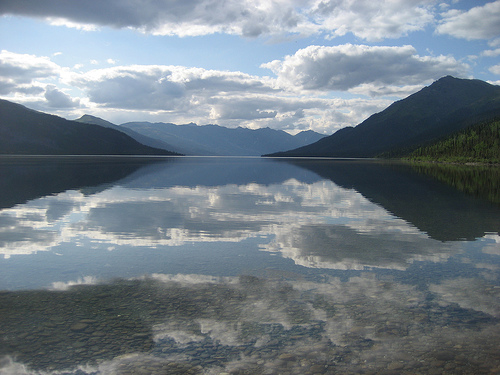
The park encompasses much of the central and eastern Brooks Range. It extends east to the Middle Fork of the Koyukuk River, which is traversed by the Dalton Highway and the Trans-Alaska Pipeline. The park spans the continental divide that separates the outlets of the Pacific and Arctic Oceans. The northernmost part of the park includes small patches of arctic foothill tundra. The Brooks Range occupies the central part of the park and runs in an east-west direction. South of the Brooks Range, the Ambler-Candalar Ridge and associated valleys and lakes run east-west. The southernmost part of the park includes the Kobuk-Selawik Lowlands, with the headwaters of the Kobuk River. The Brooks Range has been repeatedly glaciated, with the most recent glaciation, the Itkillik glaciation, lasting from about 24,000 years ago to about 1500 to 1200 years before present.
The park's name dates back to 1929, when wilderness activist Bob
Marshall, exploring the North Koyukuramal River of the Koyukuk River,
came upon a portal of mountains, one on either side of the river (the
Frigid Crags and the Boreal Mountain), which he baptized as the "Gates
of the Arctic." The area was first protected by its declaration on
December 1, 1978 as a national monument of the United States, forming
part of a group of 15 national monuments in Alaska that Jimmy Carter,
using presidential prerogative, proclaimed new national monuments, after
the United States Congress had postponed a large land purchase in that
state that had strong state opposition. Congress passed a revised
version in 1980 (which incorporated most of these national monuments
into national parks and preserves), but the Alaska National Interest
Lands Conservation Act also limited the future use of presidential
prerogative in Alaska.
On December 2, 1980, the monument became a
national park and the area was later expanded by the approval of a
national reserve on December 2, 1987. A large part of the park, 29,322
km², was also declared in 1980 as "Wilderness Area", an area adjacent to
the Noatak Wilderness Area, making up the largest wilderness area in the
United States.
The geography of the park stands out for the peaks of the Brooks
Range and the U-shaped valleys covered with tundra-type vegetation.
Among the fauna are elk, Grizzly bears, wolves, Dalli sheep, black bears
and reindeer.
Among the most important peaks in the park are the
Arrigetch Peaks and Mount Igikpak. There are also 6 rivers considered as
national wild and scenic rivers:
the Alatna River, a stretch of 134
km;
John River, 84 km;
Kobuk River 177 km;
the North Fork of
the Koyukuk River (Koyukuk North Fork), 164 km;
part of the Noatak
River;.
Tinayguk River, 71 km;
Unusually for US national
parks, about 1,500 people reside in 10 small communities in “resident
subsistence zones” that survive on the resources provided by the park.
No roads, trails, visitor services or campsites have been
established in the park. The Dalton Highway (Alaska State Highway 11),
however, approaches within 5 miles of the park's eastern border, and the
National Park Service maintains a small visitor center on the highway
near Coldfoot.
There are no official roads or trails in Gates of the Arctic National
Park and Reserve. Due to its remoteness and lack of supporting
infrastructure, the park is the least visited national park in the
United States, and one of the least visited areas in the entire United
States National Park System, which also includes national monuments,
recreational areas , reserves and historical places. In 2016, the park
received only 10,047 visitors, while Grand Canyon National Park received
almost 6 million visitors (about 600 times more) in the same year.
Camping is permitted throughout the park, but may be restricted by
easements when crossing Native Corporation lands within the park.
Park headquarters are in Fairbanks. Park Service operations in the
park are managed from the Bettles Ranger Station, south of the park.
According to the Köppen climate classification system, Gates of the
Arctic National Park and Reserve has a subarctic climate with cool
summers and year-round rainfall (Dfc). The plant hardiness zone at
Anaktuvuk Pass Ranger Station is 2b, with an average annual extreme
minimum temperature of -41.4 °C (-42.6 °F). Perennial snowfields and
Glaciers, which are crucial to several ecosystems within the park, are
shrinking at a rapid rate due to warming temperatures. Between 1985 and
2017, the surface area of these snowfields shrank by 13 km². This
warming temperatures It has also caused the permafrost to thaw, which
has directly affected the stability of the soil. As permafrost thaws, it
exposes bare soil to the elements, causing erosion and slope
failures.History
The park's name dates back to 1929, when wilderness
activist Bob Marshall, exploring the North Koyukuramal River of the
Koyukuk River, came upon a portal of mountains, one on either side of
the river (the Frigid Crags and the Boreal Mountain), which he baptized
as the "Gates of the Arctic." The area was first protected by its
declaration on December 1, 1978 as a national monument of the United
States, forming part of a group of 15 national monuments in Alaska that
Jimmy Carter, using presidential prerogative, proclaimed new national
monuments, after the United States Congress had postponed a large land
purchase in that state that had strong state opposition. Congress passed
a revised version in 1980 (which incorporated most of these national
monuments into national parks and preserves), but the Alaska National
Interest Lands Conservation Act also limited the future use of
presidential prerogative in Alaska.
On December 2, 1980, the
monument became a national park and the area was later expanded by the
approval of a national reserve on December 2, 1987. A large part of the
park, 29,322 km², was also declared in 1980 as "Wilderness Area", an
area adjacent to the Noatak Wilderness Area, making up the largest
wilderness area in the United States.
Gates of the Arctic National Park and Preserve is one of the most
remote and pristine wilderness areas in the world, located entirely
north of the Arctic Circle in northern Alaska. It centers on the central
Brooks Range, the northernmost extension of the Rocky Mountains. The
park lies approximately 200 air miles north of Fairbanks and forms part
of a vast protected complex that includes adjacent Kobuk Valley National
Park and Noatak National Preserve.
The combined park (7,523,897
acres, with 7,167,192 acres designated wilderness) and preserve units
(Eastern Itkillik and Western Kobuk River, totaling 948,608 acres) cover
about 8.47 million acres (roughly 13,238 square miles). The area
stretches nearly 200 miles east-west and 130 miles north-south,
encompassing both the north and south slopes of the Brooks Range. Its
eastern boundary runs parallel to (but a few miles west of) the Dalton
Highway, while it borders Noatak National Preserve to the west and
reaches toward the Arctic National Wildlife Refuge to the east. A small
inholding exists at the Iñupiat village of Anaktuvuk Pass; otherwise,
the landscape remains roadless and trailless.
Topography is defined
by dramatic contrasts shaped by ancient tectonic forces and repeated
Pleistocene glaciations. The Brooks Range here features rugged,
glacier-abraded peaks and ridges rising to 6,000–7,000 feet (1,800–2,100
m), with the highest summits exceeding 7,000 feet (up to about 8,570
feet in the park). Foothills on the southern side rise in waves to 4,000
feet before culminating in limestone and granite ridges. The park
includes the core Endicott Mountains and portions of the Schwatka
Mountains in the southwest.
At the heart of the range lies the Arctic
Divide (continental divide), which separates Pacific Ocean drainages
(south) from Arctic Ocean drainages (north). South of the divide, the
terrain consists of forested foothills, broad glacier-carved valleys,
and rolling lowlands. North of the divide, it transitions to treeless
Arctic foothills: rolling low-relief hills (bedrock outcrops with less
than 500-foot vertical rise, often mantled in loess), plateaus, and
tundra-covered slopes that gently descend toward the Arctic coastal
plain.
Glacial landforms dominate everywhere: deep cirque basins,
U-shaped troughs and valleys, moraines (end, lateral, and ground),
outwash terraces, eskers, kames, kettle-kame complexes, rock glaciers,
talus aprons, alluvial fans, and solifluction lobes. The Arrigetch Peaks
(a National Natural Landmark) exemplify this alpine sculpture, with
sharp granite spires, cirques, and small modern glaciers revealing
abrupt transitions from metamorphic to granitic bedrock.
Geologically, the Brooks Range consists of uplifted mid-Paleozoic to
mid-Mesozoic sedimentary rocks (sandstone, shale, limestone/carbonate)
deformed by Cretaceous thrust faulting, with scattered igneous
intrusions. Five major Pleistocene glacial advances (Gunsight Mountain
through Itkillik, plus Holocene Neoglaciation) carved the landscape. The
most recent Itkillik glaciation (roughly 26,000–1,200 years ago) left
prominent sharp-crested moraines, knob-and-kettle terrain, and outwash
plains; older deposits appear more subdued and dissected. Modern
processes—frost shattering, solifluction, avalanches, landslides, and
fluvial action—continue to sculpt the terrain. Continuous permafrost
underlies most of the area (especially north of the divide), creating
patterned ground, ice-wedge polygons, thermokarst features, and pingos
(particularly along the south-flank Kobuk fault zone).
Hydrology
features six designated National Wild and Scenic Rivers that tumble from
high alpine valleys: the Alatna (83 miles), John (52 miles), Kobuk (110
miles), part of the Noatak, North Fork of the Koyukuk (102 miles), and
Tinayguk (44 miles). These clear, braided, or meandering rivers carve
through glaciated troughs, forming floodplains, terraces, and aufeis
(sheet ice) in winter. Numerous glacial lakes dot the landscape—many in
rock basins or behind moraine dams—including Walker Lake (a National
Natural Landmark, 14 miles long and 1 mile wide, at the northern limit
of forest growth on the south slope).
Climate is subarctic (Köppen
Dfc) with extreme seasonality: long, cold winters (temperatures can drop
to -50°F or lower; extreme minimum around -42.6°F) and short, cool
summers with nearly continuous daylight. Precipitation is relatively low
(increasing in summer, peaking in August) and decreases northward. Snow
persists due to cold, but the interior is comparatively dry. Permafrost
thaw from recent warming has accelerated erosion, slope failures, and
loss of perennial snowfields/glaciers.
The landscape divides sharply
at the Arctic Divide. South slopes support sparse black spruce taiga,
boreal forest (spruce, birch, aspen, cottonwood), and transitional
shrublands in valleys and foothills. North slopes give way to vast
expanses of Arctic tundra—tussock sedge, dwarf shrubs, and wildflower
carpets in summer—stretching across foothills and plateaus toward the
Arctic Ocean. Treeline follows the divide, with isolated stands
persisting in sheltered southern valleys.