Location: Hilo, Hawaii Island Map
Area: 505.36 sq mi (1,308.9 km2)
Official site
Hawaiʻi Volcanoes National Park is a renowned national park
located on the Big Island (Hawaiʻi Island) in the state of Hawaii,
USA. This protected area, encompassing over 323,000 acres, showcases
dramatic volcanic landscapes and is recognized as a UNESCO World
Heritage Site since 1987 for its outstanding examples of active
geological processes and diverse ecosystems.
The park operates 24
hours a day, every day of the year, welcoming visitors around the
clock, though certain areas may close temporarily due to volcanic
activity, weather, or safety concerns.
Respect is essential when
visiting. Native Hawaiian culture deeply reveres the volcanoes as
sacred, viewing them as the domain of the fire goddess Pele. Always
honor local traditions, stay on designated trails, avoid disturbing
cultural sites, and follow park guidelines. Additionally, volcanic
environments are inherently hazardous—be cautious around unstable
terrain, toxic gases (like sulfur dioxide), sudden steam explosions,
cracking ground, and hot lava flows. Check current conditions via
the National Park Service or USGS Hawaiian Volcano Observatory
before heading out.
The park's terrain is incredibly diverse,
ranging from stark, black and ropy pahoehoe and jagged ʻaʻā lava
fields, to lush rainforests teeming with native ferns and ohia
trees, drier leeward forests, and rugged coastal areas with rocky
beaches. Key volcanic features include massive calderas (broad,
basin-like depressions formed by collapse, far larger than the vents
they contain), pit craters (sinkhole-like depressions from surface
collapse rather than explosive venting), twisting lava tubes, deep
crevices, steaming geothermal vents (fumaroles), and occasionally
active flowing lava at the summit.
Hawaiʻi Island itself was
built by five major shield volcanoes: Kohala (the oldest), Mauna
Kea, Hualālai, Mauna Loa, and Kīlauea.
Extinct volcanoes no
longer have the potential to erupt.
Dormant ones have not erupted
in historical times (roughly the last 200+ years in Hawaiʻi) but
could awaken in the future.
Active volcanoes have erupted within
that historical period.
Kohala, the island's eldest volcano,
last erupted around 60,000 years ago and is now extinct. Mauna Kea,
famed for its astronomical observatories, last erupted about
3,600–4,000 years ago and is considered dormant. Hualālai, Mauna
Loa, and Kīlauea remain active.
Hualālai has had seven eruptions
in the past 2,100 years, with its only historical (post-1800)
activity in 1800–1801. Mauna Loa, the world's largest active volcano
by volume and area, most recently erupted in late 2022 (November
27–December 10), after a 38-year dormancy since 1984—no eruptions
have occurred since then. Kīlauea, one of the planet's most active
volcanoes, has experienced frequent summit activity, with episodic
eruptions in Halemaʻumaʻu crater ongoing since late 2024. As of
early March 2026, Kīlauea is paused after Episode 42 ended on
February 15; the next episode (43) is forecast to potentially begin
between approximately March 10–16, based on current monitoring data
from the USGS Hawaiian Volcano Observatory. Activity remains
confined to the summit within the park, with no significant rift
zone unrest.
Offshore, the submarine volcano Lōʻihi lies about 15
miles (24 km) southeast of the Big Island, rising 3,178 feet (969 m)
below sea level. Signs of activity—including earthquakes,
hydrothermal vents, and fresh lava—confirm it is active, though it
is expected to take another 250,000 years or more before it emerges
as new land above the ocean surface.
By Car
The park is located on the southeastern side of the Big
Island (Hawaiʻi Island), along the famous Chain of Craters and near
Kīlauea volcano.
From Hilo (eastern side): Drive about 30 miles
southwest via Highway 11 (also called the Volcano Road). This scenic
route takes roughly 45 minutes under normal conditions, winding through
lush rainforests.
From Kailua-Kona (western side): The most direct
route is 96 miles southeast on Highway 11, taking 2 to 2.5 hours.
Alternatively, take the longer northern loop through Waimea (about 125
miles via Highways 19 and 11), which passes coffee farms and ranches and
takes 2.5 to 3 hours.
Road conditions can vary due to weather or
volcanic activity—check the park's current alerts before heading out.
Rental cars are widely available at airports, but note that some
off-road or unpaved sections may have restrictions.
By Bus
(Public Transit)
The Hele-On Bus (Hawaiʻi County's public transit
system) offers limited service to the park. The main route is the Red
Line (Route 11: Hilo to Volcanoes National Park), with stops including
the Volcano area. Service runs daily but is commuter-oriented, with a
few early-morning and afternoon departures (e.g., departures from Hilo
around 5:00 AM, 7:35 AM on weekdays, then midday and evening times like
1:29 PM and 4:29 PM). No service on major holidays in some cases. It's
affordable and connects to other island routes (e.g., Kona/Hilo), but
schedules are limited—ideal for budget travelers without a car. A $15
park entrance fee (7-day pass) is payable to the bus operator for
Volcano access. Always confirm the latest timetable on the Hele-On
website, as routes can adjust.
By Air
Fly into Hilo
International Airport (ITO) on the east side (closer to the park) or
Ellison Onizuka Kona International Airport (KOA) on the west side. Both
are served by major U.S. mainland and international carriers, plus
inter-island airlines like Hawaiian Airlines and Southwest for quick
hops from Oʻahu or other islands. From either airport, rent a car for
the easiest park access, as public transport options are limited.
Entrance passes are valid for 7 consecutive days and allow unlimited
re-entry during that period. All visitors age 16 and older must pay
(children 15 and under enter free). Fees are payable at entrance
stations (credit/debit cards preferred; cash may not always be
accepted).
Standard Entrance Fees
$15 per person — For
individuals entering on foot, bicycle, or motorcycle (admits one
person).
$25 per motorcycle — Covers the rider and one passenger.
$30 per private vehicle — Admits all passengers in one non-commercial
vehicle (up to a standard limit, often 15 people). Note: Organized
non-profit groups like scouts or school clubs typically don't qualify
for this rate.
Other Passes
Hawaiʻi Tri-Park Annual Pass
($55): Provides unlimited access for one full year (from first use) to
Hawaiʻi Volcanoes, Haleakalā (Maui), and Puʻuhonua o Hōnaunau National
Historical Park (Big Island). Great value if visiting multiple Hawaiian
parks.
America the Beautiful – The National Parks and Federal
Recreational Lands Pass (Interagency Pass): Covers entry to this park
and thousands of federal sites nationwide. Options include:
Annual
Pass ($80): Open to anyone; $20 for U.S. citizens/permanent residents
62+; free for active U.S. military (with CAC or Military ID).
Lifetime Senior Pass ($80 one-time): For U.S. citizens/residents 62+.
Access Pass (free lifetime): For U.S. citizens/residents with permanent
disabilities (documentation required).
Military/Veterans/Gold Star
passes (free or discounted).
Volunteer Pass (free): After 250+ hours
of volunteering with participating federal agencies.
Every Kid
Outdoors 4th Grade Pass (free annual): For 4th graders and accompanying
passengers in a vehicle (register online at everykidoutdoors.gov).
Free Entrance Days (for 2026, typically for U.S. citizens/residents;
confirm details as policies evolve):
The National Park Service offers
fee-free days at many sites, including Hawaiʻi Volcanoes:
Martin
Luther King Jr. Day (third Monday in January; next: January 19, 2026)
First day of National Park Week (third Saturday in April; next: April
18, 2026)
National Park Service Birthday (August 25)
National
Public Lands Day (fourth Saturday in September; next: September 26,
2026)
Veterans Day (November 11)
(Note: Some 2026 sources mention
additional or adjusted days like Presidents' Day, Memorial Day,
etc.—check nps.gov for the official list.)
There is no public transportation within the park boundaries, so plan to use your own vehicle, bike, or join a guided tour. The main Crater Rim Drive (11-mile loop) and Chain of Craters Road offer stunning views of calderas, craters, lava fields, and ocean entries (when active). Download or pick up free maps and brochures at the Kīlauea Visitor Center (open daily, typically 9 AM–5 PM; note occasional renovations). These include detailed road guides, trail info, ranger programs, and safety tips—essential since volcanic activity, gas emissions, and weather can close areas unexpectedly. Biking is allowed on roads, but trails vary in difficulty.
Hawaiʻi Volcanoes National Park offers an incredible opportunity to
immerse yourself in the dynamic volcanic landscape of the Big Island,
where visitors can easily spend several days (or even longer)
discovering its diverse wonders. The park highlights a wide range of
Hawaiian geological features, from ancient lava flows and lush
rainforests to dramatic craters and coastal cliffs. With Kīlauea
currently in an episodic eruption phase at its summit within
Halemaʻumaʻu crater (ongoing since late 2024, with over 42 episodes as
of early March 2026, though currently paused as of March 3, 2026, with
the next possible episode forecasted around mid-March), there's always
potential for spectacular activity—check the official USGS Hawaiian
Volcano Observatory and NPS websites for real-time updates on eruptions,
lava viewing, and safety alerts.
Start your visit at the Kīlauea
Visitor Center area (near the park entrance). Note that the main Kīlauea
Visitor Center is currently closed for renovations (expected to reopen
later in 2026), but visitor services, ranger information, maps, the NPS
Passport stamp, Junior Ranger materials, and a park store have relocated
to the Welcome Center at Kīlauea Military Camp (KMC), open daily from 9
AM to 4:45 PM. Park rangers provide the latest on trail conditions, lava
flows, volcanic gas levels, and road status. The exhibits (available in
relocated or temporary formats) cover fascinating topics like the
island's fiery formation, how life colonized Hawaiʻi via wind, wings,
and waves, diverse ecosystems stretching from ocean to mountain peaks,
the vibrant sounds and sights of the rainforest, threats from invasive
species, and conservation heroes. Throughout, you'll encounter the
profound manaʻo (wisdom) and moʻolelo (stories) of Native Hawaiians. A
popular film, Born of Fire, Born of the Sea, typically screens hourly
from 9 AM to 4 PM in the auditorium—ask about it or other ranger-led
programs, hikes, and talks, which are often excellent for gaining deeper
insights.
Right next door, the Volcano Art Center Gallery (open daily
9 AM–5 PM) showcases stunning works by local and Native Hawaiian
artists, featuring themes inspired by the volcano, culture, and nature.
It's a great spot to browse or purchase unique souvenirs like paintings,
prints, jewelry, or sculptures—though prices reflect the high quality
and can be on the higher side. Admission is free.
A must-do for every
visitor is Crater Rim Drive (west section), a scenic 6-mile partial loop
starting near Uēkahuna overlook in the west and connecting south toward
Chain of Craters Road. It offers easy access to marked overlooks and
short trails with breathtaking views of the summit caldera and ongoing
volcanic features. The full original loop was disrupted by the major
2018 eruption and subsequent events, with the southwest section
permanently closed due to road collapses and hazards—always follow
current maps and signs. Recent episodic eruptions (including tephra
fallout in early 2026) have occasionally led to temporary closures for
cleanup, but as of recent updates, accessible sections like Crater Rim
Drive West and parts of East have been open or reopened after
maintenance.
One of the park's most popular short hikes is to
Thurston Lava Tube (Nāhuku) along Crater Rim Drive. This
350–500-year-old lava tube formed when molten lava drained out, leaving
a hollow tunnel. A easy 20–40 minute loop trail winds through lush
rainforest, descends into a small pit crater, passes through a 400-foot
(120 m) lighted section of the tube (illuminated for safety and
viewing), and returns via the forest. The tube once extended farther
into darkness, but the unlighted portion remains closed due to post-2018
hazards. Access is from a dedicated parking area (with a 30-minute
limit) or the nearby Kīlauea Iki lot.
Continue down Chain of Craters
Road, a dramatic 20-mile descent dropping about 3,700 feet through
hardened lava fields to the coast, ending where lava flows from 2003
(and potentially more recent activity) overran the pavement. No services
(food, water, or gas) are available along this road, so come prepared.
Depending on volcanic conditions, the road's end sometimes offers
distant views of active lava—though current summit-focused episodes mean
viewing is more reliably from caldera rim areas rather than the coast.
Stay on designated paths and heed closures.
A highlight along Chain
of Craters Road is the Puʻuloa Petroglyph Field (at milepost 16.5).
"Puʻuloa" means "long hill" or "hill of long life" in Hawaiian, and this
sacred site in the Panau Nui ahupuaʻa holds deep cultural significance,
especially for Kalapana families. The vast pahoehoe lava surface
features over 23,000 petroglyphs (pecked images) — mostly cupules (small
holes, about 84%), but also circles, geometric patterns, enigmatic
designs, human figures, canoe sails, and feathered cape motifs. Park at
the pullout (with an emergency call box), then follow a gentle 0.7-mile
trail over undulating lava bedrock to a protective boardwalk that allows
viewing without damaging the fragile site.
Another cultural treasure
is The Footprints (accessible via the Kaʻū Desert Trailhead off Highway
11 or from Crater Rim Drive). These remarkable 1792 footprints—preserved
in volcanic ash—belong to a group of warriors caught in an explosive
eruption during a historical conflict. Stay strictly on established
trails, as the ash deposits are extremely fragile and easily damaged.
Respect this wahi pana (sacred place) by not moving rocks, removing
plants, or straying off paths.
Finally, at the end of Chain of
Craters Road, stop at the Hōlei Sea Arch viewpoint. This offers stunning
panoramic views of the rugged coastline, towering volcanic cliffs, and
the Pacific Ocean. The namesake sea arch—rising about 90 feet high—is
visible looking east, carved by relentless waves into the lava rock.
It's a dramatic, free spot to appreciate the power of both fire and
water in shaping Hawaiʻi.
Hawaiʻi Volcanoes National Park offers a fantastic variety of hiking
opportunities, with trails catering to different skill levels and
interests. Easy, family-friendly walks include the scenic Bird Park
(Kīpukā Puaulu), a gentle loop through native forest showcasing unique
Hawaiian birdlife and plants, and the short, accessible Thurston Lava
Tube (Nāhuku), where you can stroll through a stunning, fern-draped lava
tube with minimal effort. For moderately challenging adventures, popular
options like the Kīlauea Iki Trail take you across a dramatic, cooled
lava lake floor from a 1959 eruption (about 4 miles round-trip with some
steep sections), or the Mauna Iki Trail, which offers expansive views
and a sense of remote volcanic terrain. More demanding backcountry
routes venture into true wilderness areas, requiring excellent physical
fitness, proper preparation, navigation skills, and appropriate
gear—including layers for unpredictable high-elevation weather (often
cool and rainy at the summit).
Most maintained trails are
well-groomed, clearly marked, and straightforward to follow, making them
enjoyable for a wide range of visitors. In wilderness sections, trails
are more primitively indicated by ahu (traditional Hawaiian cairns—small
stacks of rocks) rather than signs. For accessibility, the Devastation
Trail (a paved boardwalk through a stark, moon-like landscape scarred by
past eruptions) and Waldron Ledge areas are wheelchair- and
stroller-friendly with smooth surfaces and scenic overlooks. Note that
some trails or sections may be temporarily closed or restricted due to
ongoing volcanic activity, recent eruptions (including episodic lava
events at Halemaʻumaʻu in 2025–2026), construction projects, or safety
concerns—always check the official NPS website or park updates for the
latest conditions before heading out.
Ranger assistance is available
at the park's visitor services, currently relocated to the Welcome
Center at Kīlauea Military Camp (open daily around 9 a.m. to 4:45 p.m.,
though exact hours can vary—confirm via the park site). Rangers provide
up-to-date trail advice, free maps, backcountry permits for overnight
hikes, and safety tips. For more details, refer to the National Park
Service resources on day hikes and overnight/backcountry options.
The Hawaiʻi Pacific Parks Association bookstore (now at the Welcome Center, adjoining visitor services) stocks a wide selection of books, guides, souvenirs, and educational materials focused on Hawaiʻi's volcanoes, native ecosystems, geology, and rich cultural history. As a non-profit cooperating association, purchases directly support the park's conservation, education, and interpretive programs. (Note: The original location near the Jaggar Museum may have limited or alternative sales.)
Inside the park, the historic Volcano House Hotel and Restaurant sits dramatically on the rim of the Kīlauea Caldera, offering meals with incredible views of the volcanic landscape (breakfast buffet, lunch, and dinner available; reservations often recommended—call +1 808-967-7321 or check their site). For more casual or varied options, head just 1–2 minutes north to the charming town of Volcano Village, home to several tasty local restaurants, cafes, and eateries serving everything from island-inspired cuisine to hearty comfort food.
Grab a quick beverage from vending machines at visitor areas or information points in the park. For a more relaxed experience with local beers, cocktails, or coffee, explore the bars and lounges in nearby Volcano Village establishments.
Lodging Options
In addition to options inside the park, you'll
find a variety of charming accommodations in the nearby Volcano Village,
a quaint, rainforest-surrounded community just 1–2 minutes north of the
park entrance. This area offers vacation rentals, bed-and-breakfasts,
and small inns for a more local feel.
Kīlauea Military Camp (KMC)
Address: 99-252 Crater Rim Dr (inside the park).
Phone: +1
808-967-8333 | Email: usarmy.kmc-reservations@mail.mil.
Check-in: 3
PM | Check-out: 11 AM.
This facility provides comfortable lodging
exclusively for eligible guests: active-duty military, retirees,
National Guard/Reserve members, DoD civilians (including Coast Guard),
and their families. It features around 90 cottages and apartments in 1-,
2-, or 3-bedroom configurations, complete with home-like amenities such
as kitchens, Wi-Fi (though connectivity can be intermittent), and access
to on-site recreational facilities. Rates vary by season and unit type
(often starting around $175+ for some cottages, but call or email for
current pricing and availability). It's a convenient, peaceful base for
exploring the park, with easy access to trails and viewpoints.
The Volcano House Hotel
Address: 1 Crater Rim Drive (dramatically
perched right on the rim of Kīlauea Caldera inside the park).
Phone:
+1 844-569-8849 | Email: frontdesk@hawaiivolcanohouse.com.
This
iconic, historic hotel—dating back to the 19th century—offers 33 guest
rooms with stunning crater views (many overlook the caldera and
potential steam plumes or lava glow from Halemaʻumaʻu). It's the only
hotel directly inside the park, providing a unique experience of waking
up to volcanic landscapes at about 4,000 feet elevation. The property
also manages rustic camper cabins and campsites at Nāmakanipaio
Campground (see below). Note that park entrance fees ($30 per
non-commercial vehicle, valid for 7 days) are separate and required.
Book early, especially during peak seasons, as it's a popular spot for
its location and history.
Camping Options
The park features
two drive-in campgrounds—Nāmakanipaio and Kulanaokuaiki—plus numerous
backcountry sites for hikers (which require free permits with a small
processing fee via Recreation.gov). Both drive-in sites are free in
terms of basic access beyond the standard park entrance fee, but they
charge per-site fees. No reservations are needed for drive-in camping;
it's first-come, first-served. Stays are limited to 7 consecutive days
per month (and no more than 30 days per year total). Always pack for
cool, damp conditions at these elevations (nights can drop into the
40s–50s°F), and bring layers.
Kulanaokuaiki Campground
Location: Off Hilina Pali Road, at about 3,200 feet (975 m)
elevation—roughly a short drive from the main park areas, with views
toward Mauna Loa.
This primitive, tent-only site has just 9 walk-in
campsites (including two wheelchair-accessible ones), each with a picnic
table and tent pad. Amenities are minimal: an accessible vault toilet is
available, but no running water, no campfires (fueled stoves only), and
no pets allowed (to protect endangered nēnē geese). The area can close
during high fire risk or dry conditions.
Fee: $10 per site per night
(as of recent years; $5 for Interagency Senior/Access Pass holders). Pay
via self-pay station on-site. It's ideal for those seeking a quieter,
more secluded experience away from crowds.
Nāmakanipaio Campground
Location: About 3 miles from the Volcano House, at 4,000 feet elevation
(roughly 31.5 miles south of Hilo on Highway 11).
This larger, open
grassy area is shaded by tall eucalyptus and 'ōhiʻa trees, offering 16
tent sites (first-come, first-served; no RVs or trailers). Facilities
include restrooms, potable water, picnic tables, and barbecue pits
(campfires permitted only in designated pits). The site is managed by
the Volcano House operators and also includes 10 rustic one-room camper
cabins (sleeping up to 4, with basic furnishings—no full kitchens, but
great for a tent-free camping vibe). These cabins are in high demand and
often require advance booking through the Volcano House.
Fee: $15 per
tent site per night (cabins cost more—around $80–$100+ depending on
season). Additional options include tent rentals if needed. Maximum stay
is 7 days. It's a classic, scenic spot with shared facilities and easy
access to park trails.
General Tips: Always check the official
NPS website (nps.gov/havo) or Volcano House/KMC sites for the latest
conditions, volcanic activity updates, fire restrictions, or
closures—Hawaiʻi Volcanoes is an active area! Pay the park entrance fee
upon arrival (or use an America the Beautiful pass), and practice Leave
No Trace principles to protect this unique volcanic environment.
All day hikers planning extended trips and those staying overnight in
the backcountry of Hawaiʻi Volcanoes National Park must obtain a free
permit (though a $10 processing fee often applies for overnight use,
payable online or as directed). These permits are now primarily managed
through Recreation.gov, where you can reserve up to 90 days in advance
for most spots (75% of permits), with the remaining 25% available in
person at the Backcountry Office up to seven days before your trip. The
office is open daily (typically 8 a.m. to 4 p.m.), and permits are
issued based on availability and campsite limits—overnight stays are
strictly regulated to protect resources and ensure safety, with maximum
consecutive nights at one site (often 3) and overall trip limits (up to
7 nights, with extensions possible for a fee). Always confirm current
details and availability directly with park staff or online, as the
process has evolved from same-day or day-before issuance at the Kīlauea
Visitor Center (which is currently closed for renovations). Check with
rangers for specific campground locations, group size limits (up to 12
people per permit in many cases), and any real-time restrictions due to
volcanic activity.
Here are essential guidelines and safety tips for
a responsible and safe backcountry experience:
Minimum Impact /
Leave No Trace Camping
Follow strict Leave No Trace principles: Pack
out everything you pack in—including all trash, food scraps, and waste.
Never bury trash, leave it behind, or dispose of it in pit toilets or
the environment. Use established campsites, stay on trails to avoid
damaging fragile vegetation, and minimize campfire impacts (see fire
rules below).
Water Availability and Treatment
The park has no
natural streams or reliable open water sources in most backcountry areas
due to the porous volcanic terrain. Backpackers must carry in sufficient
water (plan for at least 2–4 liters per person per day, more in hot or
strenuous conditions). Some designated campgrounds feature rainwater
catchment systems or tanks, but availability fluctuates—always check
current water levels and status at the Backcountry Office when picking
up your permit or via park updates. Treat or filter any collected water
before drinking to avoid illness.
Trail Conditions and Hiking
Preparation
Hiking across rugged, uneven lava fields is physically
demanding and can be slow going. Sturdy hiking boots with excellent
ankle support and traction are strongly recommended to navigate sharp,
abrasive lava rock safely. Wear long pants to protect legs from cuts if
you slip or fall on the glassy, jagged surfaces. Pace yourself
conservatively: allow at least 30 minutes per mile on mid-elevation
trails, and add extra time for elevation gains, rest breaks, scenic
viewpoints, photography, or fatigue. Start hikes early in the morning to
beat the heat and intense sun exposure.
Navigation and Sun
Protection
Trails are marked with ahu (stone cairns), which blend
into the surrounding black lava fields and may take time to spot at
first—stay alert and follow them carefully. The trails are well-defined
overall, and most hikers quickly learn to identify the cairns. Intense
tropical sunlight and reflected glare from lava can cause rapid sunburn;
protect yourself with a wide-brimmed hat, polarized sunglasses, high-SPF
sunscreen, and lip balm. Avoid midday heat when possible.
Health and
Weather Hazards
Trails pass through exposed, sun-baked lava deserts
and lush, wet rainforests—conditions change quickly. Maintain a steady
pace, stay hydrated, and take frequent breaks. Pack extra layers, a warm
sleeping bag (store in waterproof bags), and essential raingear, as
sudden downpours are common. Hypothermia is a serious risk if you get
wet and cold, even in mild temperatures—stay dry and warm. Prepare for
injuries from falls on sharp lava: carry a well-stocked first-aid kit
with bandages, antiseptic, tweezers for removing glass-like fragments,
and blister care.
Volcanic Hazards
Eruptions can occur without
warning in this active volcanic landscape. If lava activity begins near
your trail, move uphill and upwind immediately to avoid toxic gases,
heat, and flows. Be extremely cautious of earth cracks, thin lava crusts
that may collapse, hidden lava tubes, unstable ground, and rockfalls.
Stay on marked trails—venturing off can lead to dangerous falls or
entrapment.
Fire Safety
Many areas feature highly flammable
dry grasses and brush. Open fires, campfires, and smoking are strictly
prohibited throughout the backcountry to prevent wildfires.
Protecting Cultural and Natural Resources
The park preserves
significant archaeological sites, artifacts, and sacred places from
ancient Hawaiian culture. Never move rocks, climb on or disturb
structures like heiau (temples), lava trees, stone walls, petroglyphs,
or other features. Entering caves is forbidden. All plants, animals,
rocks, minerals, and cultural/natural objects are protected by federal
law—removing, damaging, or altering them is illegal and punishable.
Prohibited Items
Dogs (and other pets) are not allowed in the
wilderness/backcountry areas. Firearms are also prohibited.
Trip
Planning and Emergency Procedures
Before heading out, share a
detailed trip plan with a trusted friend or family member, including
your route, expected duration, and return time. Instruct them to notify
authorities if you don't check in by the agreed deadline. If you become
lost or injured, stay put in one place to aid rescuers—use bright
clothing, reflective items, a whistle, or signal mirror to attract
attention. Park rangers typically wait 24 hours after notification
before launching a full search. In an emergency, call Hawaii County 911.
Checking Out After Your Trip
Upon completing your hike, return to
the Backcountry Office (or Kīlauea Visitor Center area if applicable) to
check out and inform rangers you've safely exited. This is crucial in
this dynamic volcanic environment—accurate tracking helps rangers
account for everyone during potential eruptions or emergencies.
Please show deep respect for the natural environment and cultural
heritage of Hawaiʻi Volcanoes National Park by refraining from removing
or disturbing any natural elements, such as rocks, lava stones, sand,
pumice, or other materials. This includes anything within the park
boundaries or across the Hawaiian Islands more broadly.
Visitors to
the park often hear stories about Pele, the powerful Hawaiian goddess of
volcanoes, fire, and creation. According to a popular legend (sometimes
called "Pele's Curse"), anyone who takes volcanic rocks or other natural
items from Hawaiʻi—even from areas outside the national park—may
experience misfortune, bad luck, or other troubles as a form of Pele's
displeasure. While this tale is more of a modern urban legend than an
ancient taboo, it has become deeply ingrained in local culture. Many
tourists who have taken souvenirs later mail them back to the islands
hoping to lift the supposed curse.
Beyond the legend, removing any
natural materials is strictly illegal within a U.S. national park and
can result in fines or penalties. It is also considered unethical and
disrespectful by many Hawaiians for religious, spiritual, moral, and
environmental reasons—the islands' fragile ecosystems and sacred
landscapes deserve protection. The guiding principle is simple and
timeless: Take only pictures, leave only footprints (and ideally, no
trace at all).
Hawaiʻi Volcanoes National Park features rugged, ever-changing
terrain shaped by active volcanoes like Kīlauea, so prioritize safety at
all times.
Dress appropriately: Wear sturdy, closed-toe hiking
shoes (no sandals or flip-flops) and long pants to protect against sharp
lava rock, uneven ground, and potential scrapes or burns.
Hydrate
frequently: Bring plenty of water—at least 2–3 liters per person for
longer hikes—and drink regularly, as the high elevation, sun, and dry
air can lead to quick dehydration.
Time your activities wisely: Avoid
hiking after dark, when visibility drops and hazards become harder to
spot.
Stick to designated paths: Always stay on marked trails and
overlooks. Loose vegetation, cinders, or thin lava crust can conceal
deep cracks (fissures), unstable ground, or hidden holes in the earth.
Exercise extreme caution near natural features: Be especially careful
around cliff edges, cracks, steam vents, and unstable ground—these areas
often have slippery surfaces, crumbling edges, or sudden drop-offs.
Supervise small children constantly and keep them close.
Understand
lava terrain risks: Walking over loose rocks, thin lava shells, cracks,
or unstable surfaces significantly raises the chance of injury. Falling
onto rough lava can cause deep cuts, burns, fractures, or other serious
wounds.
Be aware of volcanic gases (vog and fumes): Harmful
emissions, including sulfur dioxide and other gases, can irritate eyes,
skin, and lungs. People with heart conditions, respiratory issues (like
asthma), infants, young children, pregnant women, or the elderly are at
higher risk and should avoid areas with noticeable fumes, such as
Halemaʻumaʻu Crater, Sulphur Banks, or other fume-heavy zones. Check
current air quality reports, as levels can fluctuate and sometimes lead
to temporary closures.
Prepare for sudden eruptions: Volcanic
activity can start without warning and pose extreme dangers. Even from a
safe distance, airborne fallout like Pele's hair (fine glassy strands),
pumice, ash, or cinder can irritate lungs and eyes. Monitor USGS
Hawaiian Volcano Observatory updates for real-time status.
Follow
official guidance: Always obey park rangers' instructions, posted signs,
road closures, and trail alerts. Never enter restricted or closed
areas—these are often shut due to risks like large-scale land collapses,
high gas levels, unstable cliffs, or active hazards. (Note: Some
closures date back years, with ongoing ones related to recent activity
and construction; check the park's current alerts and maps for the
latest details.)
No safe ocean access: The park has no designated
beaches or safe swimming spots. Expect powerful winds, sheer and
unstable sea cliffs, strong currents, and massive waves that make the
coastline extremely dangerous.
Hawaiʻi Volcanoes National Park lies on the southeastern flank of the
Big Island (Hawaiʻi Island) in the U.S. state of Hawaiʻi, southwest of
the town of Hilo. It protects a dramatic, ever-changing volcanic
landscape shaped by two of the world’s most active shield volcanoes:
Kīlauea (one of the most active on Earth) and Mauna Loa (the largest
active volcano by volume).
The park spans 354,461 acres (roughly 554
square miles), extending from sea level along the rugged Puna coastline
to the summit of Mauna Loa at 13,681 feet (4,170 m). It is a UNESCO
World Heritage Site and International Biosphere Reserve.
Geological Formation and Hotspot Origin
The park’s geography stems
from the Hawaiian hotspot—a stationary mantle plume beneath the moving
Pacific Plate. As the plate drifts northwest at 2–4 inches (5–10 cm) per
year, magma rises, building successive shield volcanoes. Older islands
(like Kauaʻi, ~5.5 million years old) lie northwest; the Big Island is
the youngest, with exposed rocks as young as 0.7 million years. A new
seamount (Lōʻihi) is forming offshore southeast of Kīlauea.
Both
volcanoes in the park are shield volcanoes: broad, gently sloping domes
built from low-viscosity basaltic lava that flows far before cooling.
They lack the steep cones of explosive stratovolcanoes. Repeated thin
lava layers create the massive, low-angle profiles. Eruptions add new
land, bury old terrain, and constantly reshape the surface.
Mauna
Loa: Earth’s Largest Shield Volcano
Mauna Loa covers about 51% of the
Big Island and rises 13,681 feet (4,170 m) above sea level—plus another
~30,000 feet (9,144 m) from the ocean floor—making its total height
greater than Mount Everest. Its immense mass depresses the seafloor
beneath it.
Summit caldera: Moku‘āweoweo (roughly 2–3 miles
across).
Rift zones: Northeast and southwest (primary); some radial
vents northwest.
Surface: About 90% covered by flows less than 4,000
years old.
Eruptions often start at the summit and migrate down
rift zones, producing high-volume flows that travel miles. Since 1843,
it has erupted 34 times (roughly once every 5–6 years on average).
Notable events include the 1950 southwest rift zone flow (reaching the
ocean in under 3 hours) and the 1984 northeast rift zone activity
threatening Hilo.
Kīlauea: Youngest and Most Active
Kīlauea
formed underwater ~280,000 years ago and is slightly smaller than Oʻahu
in surface area. Nearly 90% of its slopes are covered by lava flows from
the past 1,000 years (20% from the last 200 years).
Summit
caldera: Contains the persistently active Halemaʻumaʻu pit crater
(historically a lava lake site).
Rift zones: East Rift Zone (highly
active, site of the 1983–2018 Puʻu ʻŌʻō eruption and 2018 lower East
Rift fissure outbreaks) and Southwest Rift Zone.
2018 activity: A
major East Rift eruption triggered summit collapse, expanding
Halemaʻumaʻu dramatically (to ~1,600 feet deep and 1.5 miles wide). A
water lake briefly formed before a new lava lake reappeared in 2021.
Diverse Landforms and Topographic Features
The park’s terrain
mixes vast, fresh lava fields with older vegetated pockets and dramatic
voids:
Lava flows — Two main types dominate: pāhoehoe (smooth,
ropy, billowy surfaces from fluid lava) and ʻaʻā (rough, jagged,
clinkery rubble from more viscous or faster-cooling lava). These create
contrasting textures across hundreds of square miles.
Lava tubes —
Formed when the surface of a lava river crusts over while the interior
continues flowing; these create miles of subterranean passages (e.g.,
the accessible Nāhuku/Thurston Lava Tube).
Kīpuka — “Islands” of
older forest surrounded by younger flows, preserving pockets of native
vegetation amid barren new lava.
Pit craters and cinder cones —
Collapse pits (e.g., along rift zones) and spatter ramparts/cinder cones
built around vents.
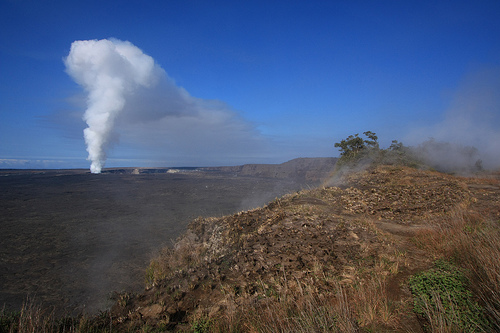
Steam vents, sulphur banks, and fumaroles —
Geothermal features releasing volcanic gases, creating colorful mineral
deposits and acidic micro-environments.
Coastal features — Where lava
reaches the sea (especially along Chain of Craters Road), it forms black
sand beaches, new land deltas, and dramatic sea arches carved by wave
erosion of hardened flows.
Kaʻū Desert — A striking barren zone on
the southwest slope, created by a rain shadow (see climate below) plus
acid rain from volcanic gases that stunts vegetation and makes the
permeable lava absorb rainfall quickly.
Climate, Weather, and
Elevation-Driven Zones
Weather is famously unpredictable and varies
dramatically with elevation and the rain shadow effect. Northeast trade
winds bring moisture that rises and condenses on windward slopes (heavy
rain), then descends dry and warm on leeward sides.
Coastal plain
(end of Chain of Craters Road): Hot, dry, windy; occasional showers.
Kīlauea summit (~4,000 ft): 12–15°F cooler than sea level; rainy and
chilly year-round.
Mauna Loa summit (~13,681 ft): Alpine
conditions—possible snow or freezing nights any season, daytime heat
possible.
The park spans at least six of Earth’s climate zones:
lush tropical rainforest (windward mid-elevations, with tree ferns and
ohia forests), wet woodlands, dry forests, arid desert (Kaʻū), and
alpine/tundra at the highest elevations. Annual rainfall ranges from
over 100 inches in wet areas to very low in the rain shadow. Volcanic
gases (especially SO₂) can create localized acid rain (pH as low as 3.4)
that further inhibits plant growth in places like the Kaʻū Desert.
Surface hydrology is minimal: the highly porous basalt lava absorbs most
rainwater, so there are few permanent streams or rivers. Instead, water
moves underground, emerging in coastal springs or as steam vents.
Dynamic and Ongoing Changes
Hawaiʻi Volcanoes National Park is
one of the best places on Earth to witness active geology. Eruptions,
collapses, inflation/deflation cycles, and lava flows continuously alter
elevations, add new coastline, bury trails, and create fresh landforms.
Features like lava lakes, fissures, and new kipuka appear or evolve with
each event. The landscape you see today is merely a snapshot in an
ongoing process that has built the entire Hawaiian Island chain.