Location: Hawaii Island, HI Map
Kīlauea Volcano (pronounced kee-lah-WAY-ah, meaning “much
spreading” in Hawaiian) is one of the world’s most active and
best-studied shield volcanoes. It lies on the southeastern flank
of the Island of Hawaiʻi (the Big Island) within
Hawaiʻi Volcanoes National Park, a UNESCO World Heritage
Site.
Its summit sits at approximately 1,222–1,247 m
(4,009–4,091 ft) above sea level, with coordinates 19.421° N,
155.287° W. Although it appears as a modest bulge on the
enormous southeastern slope of its neighbor Mauna Loa, Kīlauea
is a fully independent volcano with its own deep magma plumbing
system extending more than 60 km into the Earth. Its summit
actually aligns with the volcanic line that includes Mauna Kea
and Kohala, not Mauna Loa.
Overall Structure and Topography
Kīlauea is a classic shield
volcano in the shield-building stage of Hawaiian hotspot volcanism. It
formed as the Pacific Plate moved northwest over the Hawaiian hotspot.
The volcano is roughly 210,000–280,000 years old (submarine lavas),
emerged above sea level about 100,000 years ago, and has been actively
building its subaerial edifice for the past ~155,000 years (transition
to shield stage).
Its subaerial portion covers about 1,500 km² with
broad, gently sloping flanks (typically 3–5° slopes) that merge
seamlessly with Mauna Loa to the west and north. Much of the volcano
lies underwater; the East Rift Zone, for example, extends ~110 km from
the summit before plunging to depths greater than 5,000 m below sea
level.
The surface is extremely young: 90% is covered by lava flows
younger than 1,000 years, and about 20% of those are less than 200 years
old. Only 10% of the exposed rock is older than 1,000 years. The oldest
subaerial lavas (Hilina Basalt) appear in fault scarps on the south
flank and date to 50,000–70,000 years ago.
This constant resurfacing
creates a dynamic landscape of fresh black basalt, kipukas (islands of
older vegetation surrounded by younger flows), lava tubes, tree molds,
and coastal lava deltas where flows meet the Pacific Ocean.
Summit Caldera (Kaluapele)
The summit features a large collapse
caldera called Kaluapele (Kīlauea Crater), measuring roughly 3–3.5 km by
5 km (about 2.2 mi × 1.9–3 mi) with a collapsed volume of 4–6 km³. It
formed incrementally between roughly 200–500 years ago (around 1470 CE
after the massive ‘Ailā‘au eruption drained the underlying magma
chamber). The caldera floor has varied dramatically in depth over
time—once at least 600 m (1,970 ft) deep relative to the rim—but
repeated lava filling and collapses have kept it shallower in recent
centuries.
Inside the caldera sits the iconic Halemaʻumaʻu pit crater
(“house of the fire god”), the traditional home of Pele in Hawaiian
culture and the site of persistent activity. Numerous other pit craters
and fractures ring the summit.
Rift Zones
Two prominent rift
zones radiate from the summit and serve as the primary pathways for
magma intrusion and eruption:
East Rift Zone (ERZ): The dominant
feature. It runs ~110 km southeastward from the caldera, across the Puna
district, and far offshore. It hosts abundant pit craters (e.g., Nāpau,
Kīlauea Iki, Hiʻiaka, Pauahi), fissures, and historic vents such as
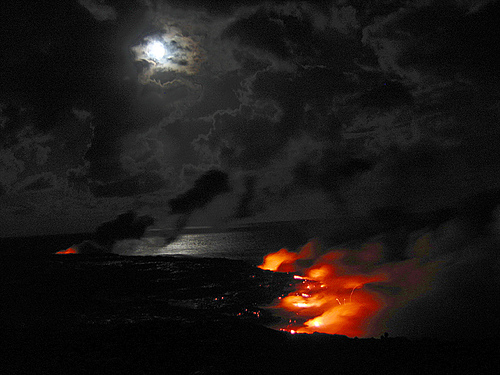
Puʻuʻōʻō (1983–2018) and Maunaulu (1969–1974). The lower ERZ produced
the destructive 2018 eruption that created new land and destroyed
hundreds of homes.
Southwest Rift Zone (SWRZ): Shorter and less
active, with a more limited submarine extension. It features fissures
and occasional vents (e.g., the June 2024 eruption).
The rift
zones appear as linear topographic highs with cracks, small normal
faults, and chains of pit craters formed by magma withdrawal and
collapse. Pit craters are far more numerous along the ERZ than the SWRZ.
Fault Systems and Flank Features
South of the caldera lies the
Koaʻe Fault System—a zone of north-facing normal faults and open
fractures between the two rift zones. It acts as a “tear-away” structure
accommodating the southward sliding of Kīlauea’s south flank at rates of
3–6 cm/year. Farther south (outside the summit map area) are the
dramatic Hilina Pali fault scarps, related to long-term seaward
subsidence.
The south flank is unstable; large earthquakes (such as
the magnitude 7.2 event in 1975) have produced coastal subsidence and
tsunamis. Where lava reaches the sea, it builds unstable lava deltas and
sea arches that frequently collapse.
Dynamic Geography Shaped by
Eruptions
Kīlauea’s geography is not static. Eruptions cycle between
long effusive periods (building shields and filling the caldera with
pahoehoe and ʻaʻā flows) and shorter explosive phases (producing thick
tephra layers and widening the caldera). The 2018 lower East Rift Zone
eruption and summit collapse dramatically altered the landscape,
dropping the caldera floor and adding new coastal land. As of early
2026, episodic lava fountaining continues within Halemaʻumaʻu, further
modifying the summit floor.
Geological Formation and Early History
Kīlauea began as a
submarine volcano above the Hawaiian hotspot. The oldest recovered lavas
(alkali basalts) erupted onto the seafloor between 210,000 and 280,000
years ago. It transitioned from the pre-shield stage to the main
shield-building stage around 155,000 years ago. The oldest subaerial
(above-sea-level) rocks exposed on land date to roughly 50,000–70,000
years ago and are found in the Hilina fault scarps on the south flank.
Because 90 % of the volcano’s surface is covered by lava flows younger
than 1,000 years (and 20 % younger than 200 years), the full early
history is reconstructed mainly from submarine deposits and drill cores.
Only the past ~2,500 years of activity is well documented on land. For
most of this time, effusive (lava-flow-dominated) eruptions were the
norm. Magma supply rate controls the style: high supply keeps the summit
reservoir full and feeds frequent lava flows; low supply drains the
reservoir, causing caldera collapse and potentially explosive
steam-driven (phreatomagmatic) eruptions when groundwater interacts with
hot rock or magma.
Prehistoric Eruptive History (Past 2,500+
Years)
Around 2,200 years ago (circa 200 BCE), a major collapse
formed the “Powers caldera,” the precursor to today’s summit caldera.
The floor dropped at least 620 m (2,030 ft), triggering a
1,200-year-long period of powerful explosive eruptions that blanketed
the volcano and surrounding areas with the Uwekahuna tephra deposit. The
most violent of these occurred between 850 and 950 CE, hurling 4.4 kg
(9.7 lb) rocks at least 5 km (3 mi) and golf-ball-sized fragments 18 km
(11 mi) to the coast.
Effusive activity resumed about 1,000 years ago
(circa 1000 CE). Lava flows filled the old caldera and built the
Observatory shield (a broad, gently sloping feature southwest of the
modern caldera). Human settlement on Hawaiʻi Island likely began in the
mid-13th century, roughly 200–250 years after this shield started
forming. Around 1400 CE the Observatory shield finished growing. Soon
afterward came the ʻAilāʻau eruption (circa 1400–1470 CE), the longest
known Hawaiian eruption witnessed by humans. Lasting about 60 years, it
poured lava from a vent near today’s Thurston Lava Tube (Nāhuku) all the
way to the north coast, covering much of eastern Kīlauea. Its volume
roughly matched the amount of magma later withdrawn to form the modern
caldera.
The present-day Kaluapele caldera formed shortly after the
ʻAilāʻau eruption ended (roughly 1470–1510 CE). The floor dropped about
600 m (1,970 ft), creating a depression 3.5 × 3 km across with a
collapsed volume of 4–6 km³. Hawaiian oral traditions (moʻolelo)
describe Pele’s youngest sister Hiʻiaka “digging” this deep
pit—interpreted today as a poetic record of the dramatic summit
collapse.
A second prolonged explosive interval followed (circa
1510–1800 CE), producing the 11-m-thick (35-ft) Keanakākoʻi tephra
blanket. At least four major explosive events sent ash into the jet
stream. The final major event in this period was the 1790 eruption, the
deadliest volcanic eruption in U.S. or Hawaiian Kingdom history.
Pyroclastic surges raced 3.5 km (2.1 mi) down the west flank, killing
several hundred (possibly over 1,000) people near the modern Hawaiian
Volcano Observatory site. Ashfall 2 cm (0.8 in) thick preserved
footprints of fleeing travelers.
Cultural and Mythological
Significance
In Hawaiian tradition, Kīlauea is the domain of Pele
(Pelehonuamea), the goddess of fire, lightning, volcanoes, wind, and the
creator/destroyer of land. Oral histories say Pele was born in the
distant land of Kahiki (Tahiti) and voyaged through the islands between
850 and 1250 CE, digging craters until she settled permanently in
Halemaʻumaʻu crater at Kīlauea’s summit. From there she governs the
districts of Puna and Kaʻū. Ancient chants (oli) describe her dual role:
she destroys old land with lava but creates new islands and fertile
soil. She is revered as ʻohana (family) and an ʻaumakua (ancestral
guardian) by many Native Hawaiians in Puna and Kaʻū. Traditions include
leaving offerings (such as ohelo berries) before entering her realm and
the widespread belief that removing lava rocks, sand, or other natural
materials brings misfortune (“Pele’s Curse”).
Historic and Modern
Eruptions (1823–2018)
The first well-documented European visit to the
summit occurred in 1823 (Rev. William Ellis). The volcano was nearly
continuously active through much of the 19th and early 20th centuries.
Notable events include:
1924 — A 17-day phreatic (steam-driven)
explosion in Halemaʻumaʻu after the lava lake drained; multi-ton rocks
were hurled 1 km.
1959 — The spectacular Kīlauea Iki eruption with
580 m (1,900 ft) lava fountains.
1960 — Destruction of the village of
Kapoho by lava flows.
The longest and most voluminous modern
eruption began in 1983 at Puʻuʻōʻō vent on the East Rift Zone. For 35
years (until 2018) lava erupted almost continuously from Puʻuʻōʻō and
later Kupaianaha vents, building a new shield and adding hundreds of
acres of land to the southeast coast. From 2008 to 2018 a lava lake also
occupied Halemaʻumaʻu at the summit, producing a persistent gas plume.
The 2018 lower East Rift Zone eruption dramatically ended the 35-year
episode. Magma intruded into the lower East Rift Zone in May, opening 24
fissures across a 6 km stretch. The largest fissure (Fissure 8) produced
a 300 m (1,000 ft) lava fountain and massive channelized flows that
destroyed more than 700 homes in Leilani Estates and covered 35 km² (14
mi²). Simultaneously, the summit lava lake drained, triggering the
largest caldera collapse in 200+ years: the Halemaʻumaʻu crater floor
dropped ~500 m (1,640 ft) over two months, with more than 60,000
earthquakes and daily explosions. The eruption ended in August 2018.
Post-2018 Summit Eruptions and Current Activity (2020–2026)
After
2018 the volcano was quiet for about 18 months. Beginning in December
2020, a series of five short-lived summit eruptions within the new,
deeper Halemaʻumaʻu crater slowly refilled the collapse depression with
~410 m (1,345 ft) of lava by late 2023.
In 2024 activity shifted: a
brief fissure eruption occurred on the upper Southwest Rift Zone (June
3), followed by a 5-day eruption in and near Nāpau Crater on the middle
East Rift Zone (September 15–20). Several intrusions also occurred in
the upper East Rift Zone.
The current eruption began on December 23,
2024, inside Halemaʻumaʻu. It has been episodic lava fountaining from
two main vents (north and south) plus occasional intermediate vents. As
of early March 2026 the eruption has produced 42 discrete episodes. Each
episode begins with rapid inflation, followed by hours to days of high
fountains (heights up to 479 m / 1,570 ft recorded) and voluminous lava
flows that remain confined to the crater floor. Pauses between episodes
last days to weeks. By episode 42 the eruption had added 242.4 million
m³ of lava, raising the crater floor an average of 80 m (max 160 m)
across 420 hectares. Tephra includes Pele’s hair, scoria, and a small
spatter cone. As of February 2026 the eruption is paused (episode 42
ended February 15), with the next episode (43) forecast for roughly
March 10–16, 2026.
Current Status and How to Stay Updated
Primary sources:
USGS
Hawaiian Volcano Observatory:
https://www.usgs.gov/volcanoes/kilauea/volcano-updates (daily/weekly
reports, webcams, and forecasts).
NPS Hawaiʻi Volcanoes National Park
site: https://www.nps.gov/havo/index.htm (alerts, conditions, closures,
and eruption viewing info).
Webcams provide live views of the
summit—ideal for checking glow or activity remotely.
Eruptions are
episodic: pauses last days to weeks, active phases feature lava
fountains and glow in Halemaʻumaʻu, often visible at night but not
always from public overlooks during pauses.
No active lava is
currently viewable from public areas during pauses, but steam, glow (if
resuming), and dramatic crater landscapes remain highlights.
Safety Tips (Critical—Volcanic Hazards Are Real)
Kīlauea is generally
safe when you follow rules, but risks include volcanic gases (SO₂, vog),
unstable ground, cracks, cliff edges, rockfalls, and sudden changes
during eruptions.
Never enter closed/restricted areas — Rope
lines, signs, and barriers exist for good reason (fumes, collapses,
cracks). Trespassing has caused serious incidents, including near-fatal
falls.
Stay on marked trails and overlooks — Do not venture
off-trail, especially at night or near edges.
Volcanic gas (vog)
precautions — Hazardous for respiratory issues, asthma, young children,
pregnant people, or elderly. Have medications ready; leave if air
quality worsens (check airnow.gov or hiso2index.info). Masks (N95 if
needed) and goggles help in windy conditions.
Other hazards — Wear
closed-toe sturdy shoes (sharp lava, uneven terrain). Avoid valleys/low
areas during potential flows. No touching lava or hot rocks.
During
eruptions — Crowds surge; arrive early. Night viewing of glow is
spectacular but riskier—use headlamps/flashlights.
General — Park
rangers provide real-time guidance. Follow all signs and instructions.
Best Time to Visit
Time of day — Early morning (sunrise views,
fewer crowds, parking easier) or late evening/night (eruption glow if
active). Avoid midday crowds/heat.
Season — Year-round viable (temps
66–85°F), but spring/fall offer milder weather and fewer crowds.
Summer/winter holidays are busiest. Rainier in winter/early spring;
hurricane season June–November brings variable weather.
Current
window — With Episode 43 possibly starting mid-March 2026, monitor
closely—if it resumes, nighttime glow viewing could be prime.
Practical Travel Tips
Getting there — Fly into Hilo (closer, ~30–45
min drive) or Kona (2.5–3 hours drive). Park entrance fee ~$30/vehicle
(good for 7 days); America the Beautiful pass accepted.
Entrance and
parking — Arrive early—lots fill by late morning, especially near
summit. Park open 24/7.
Visitor Center — Currently closed for
renovation (since March 2025)—check NPS for updates on temporary
facilities or ranger talks.
What to bring:
Layers (cool/foggy at
~4,000 ft elevation; jacket/sweater essential).
Rain gear (sudden
showers common).
Sun protection, water, snacks (limited facilities).
Headlamp/flashlight for night.
Camera/binoculars for distant views.
Key spots to visit:
Kīlauea Overlook / Steam Vents — Classic
views of caldera.
Halemaʻumaʻu viewpoints (if open/safe) — For
eruption glow.
Devastation Trail — Easy boardwalk through 1959
eruption landscape.
Chain of Craters Road — Scenic drive (check for
closures), lava fields, coastal views.
Thurston Lava Tube — Short,
family-friendly walk through a tube.
Guided options — Consider
ranger-led programs (when available) or reputable lava/park tours for
expert insights and safety.
Nearby — Stay in Volcano Village for
convenience (lodging, food). Respect cultural significance—Kīlauea is
sacred to Native Hawaiians (mālama ʻāina: care for the land).