Location: Anchorage, Alaska Map
Area: 4,030,025 acres (16,308 km²)
Official site
Lake Clark National Park and Preserve is a vast, remote wilderness in
south-central Alaska, encompassing approximately 4 million acres (about
1.63 million hectares or 6,250 square miles) across the north end of the
Alaska Peninsula. It lies roughly 100 miles (160 km) southwest of
Anchorage, with coordinates centered around 60°58′N 153°25′W. The park
and adjoining preserve straddle a dramatic transition zone where the
Alaska Range meets the Aleutian Range via the Chigmit Mountains. No
roads enter the park; access is solely by small aircraft or boat, often
through the low-elevation Lake Clark Pass (1,050 feet / 320 m).
The park protects a spectacular convergence of coastal, alpine, and
interior landscapes shaped by ongoing tectonic, volcanic, and glacial
forces. It forms part of the headwaters for the Bristol Bay
watershed—one of the world’s most productive salmon ecosystems—while
featuring active volcanoes, thousands of glaciers, turquoise glacial
lakes, braided rivers, and rugged peaks rising directly from the western
shores of Cook Inlet.
Geological Origins and the Dawn of Human Presence (Pre-10,000 Years
Ago to ~1,000 CE)
Lake Clark itself—known in Dena'ina as Qizhjeh Vena
("lake where people gather")—formed more than 10,000 years ago during
the rapid warming at the end of the last Ice Age (Pleistocene).
Retreating glaciers carved deep valleys and basins in the bedrock of the
Chigmit and Neacola Mountains (part of the Alaska and Aleutian Ranges),
filling them with meltwater. The resulting long, narrow, deep lake is
fed by turquoise glacial rivers carrying fine "flour" silt. Surviving
glaciers in the surrounding peaks continue to drain into the system
today.
The first humans arrived in the region shortly after the ice
retreated, drawn by abundant resources: salmon runs, caribou, moose,
waterfowl, berries, and plants still harvested today. Archaeological
evidence reveals a sequence of traditions:
Paleo-Arctic
(10,000–7,500 years before present): Microblade technology, possibly
linked to Siberian migrations.
Northern Archaic (6,000–4,000 BP):
Documented at two park sites; focused on caribou hunting.
Arctic
Small Tool (5,000–3,000 BP).
Norton (2,200–1,000 BP): Concentrated
around Bristol Bay.
Thule (from ~2,000 BP): Ancestral to later
Inuit/Yup'ik influences, blending into historic times.
By around
1,000 CE (during the Medieval Warm Period), Inland Dena'ina Athabascan
people—speakers of an Athabascan language—had established a more
sedentary lifestyle centered on salmon. They differentiated from related
groups (e.g., Upper Kuskokwim) around 500 BCE, migrating into the area
via river systems and passes like Telaquana. Place names in Dena'ina
encode deep ecological and historical knowledge, such as Qizhjeh ("a
place where people gather") for the major village site and Tuvughna Ten
("people from Tyonek went through there") for trails.
Dena'ina
Lifeways and the Flourishing of Qizhjeh/Kijik (Pre-Contact to Early
Contact)
The Dena'ina (also called Tanaina or Inland Dena'ina) viewed
the landscape as a sentient, spiritual ecology with multi-dimensional
cosmology involving humans, ancestors, animals, spirits, and "beggesh"
(energies tied to places and artifacts). They practiced animistic
rituals—returning animal bones to reincarnation sites, avoiding waste,
and burning personal items—to maintain balance with "K’unkda Jelen"
(Mother of Everything Over and Over). Oral histories (sukdu) and clan
stories (matrilineal moieties with clans like Nulchina/Sky Clan)
describe migrations, wars with Yup'ik and Alutiiq neighbors, and ethical
relationships with the land.
Subsistence revolved around a seasonal
round: spring fishing camps, summer fish camps (shan nuch’etdeh) with
weirs and dip nets, fall hunting/trapping (tunch’edat), and winter ice
fishing/potlatch gatherings. Salmon (especially sockeye from Lake Clark,
source of roughly half of Bristol Bay's runs) were central—dried,
smoked, cached in underground birch-lined pits (ełnen tugh), and honored
in first-salmon ceremonies. Other resources included caribou/moose
(hunted with sinew-backed bows, snares, fences), berries (blueberries,
salmonberries for "Native ice cream"/nivagi), whitefish, pike, birds,
and plants for food, medicine, and crafts (birch-bark baskets, spruce
boats). Trade networks linked inland Dena'ina with coastal groups via
rivers, lakes, and trails like the Telaquana Trail.
The largest and
most significant settlement was Qizhjeh (Kijik), on the shores of Lake
Clark—a sprawling village covering more than 25 acres with hundreds of
house foundations, log cabins, and a Holy Cross Chapel. Occupied for
nearly 900 years (radiocarbon dates from ~1170 CE), it served as a trade
hub supporting 20–30 families at peak, with qeshqa (wealthy chiefs)
organizing hunts, redistribution via potlatches, and protection. Kijik
(now a National Historic Landmark and archaeological district) thrived
on the lake's fish and surrounding game; its Dena'ina name echoes in
nearby Kijik Lake and River. Other sites included villages along the
Stony/Mulchatna Rivers, Telaquana Lake, and Iliamna areas, with seasonal
mobility across the landscape.
Russian Contact, Fur Trade, and
Orthodox Influence (1741–1867)
The first written European records of
Alaska date to Vitus Bering's 1741 voyage, though the Lake Clark/Iliamna
interior saw limited direct contact initially. Russian fur traders
(promyshlenniki) followed, plundering villages in 1792 and prompting
Dena'ina retaliation (destruction of posts on Iliamna Lake in 1800).
Relations stabilized by the 1820s. Russian Orthodox missionaries arrived
in 1794; by the 1830s, traveling priests conducted baptisms and
services, blending with Dena'ina beliefs in a syncretic practice still
vibrant today (e.g., star-spinning Christmas traditions in villages like
Lime Village).
The fur trade integrated Dena'ina as trappers and
middlemen (qeshqa enhanced their roles), introducing metal tools, guns,
and beads but also dependency on company stores and overhunting
pressures. Epidemics (smallpox in the 1830s) halved populations
regionally. Trade posts appeared at Iliamna and Mulchatna; intermarriage
occurred. Dena'ina resistance and adaptation preserved core subsistence
and cultural practices amid these changes.
American Acquisition,
Exploration, Naming, and Turmoil (1867–Early 1900s)
Russia sold
Alaska to the United States in 1867 ("Seward's Folly," ~3 cents per
acre). The first detailed Euro-American account of Lake Clark came in
1881 from naturalist Charles Leslie McKay (Smithsonian). In 1891,
explorer Alfred B. Schanz's party— including John W. Clark of the Alaska
Commercial Company—traversed the area via the Mulchatna and Chulitna
Rivers. They renamed Qizhjeh Vena as "Lake Clark" (despite knowing the
Dena'ina name), with the Americanized pronunciation of the village
becoming "Kijik."
The first permanent Euro-American resident arrived
in 1903: trapper and gardener Brown Carlson at Tanalian Point. The
Alaska Gold Rush spilled into the region; prospectors, miners, and USGS
teams explored the Chigmit/Neacola Mountains and Bonanza Hills. Local
Dena'ina panned gold and sold furs. Commercial fishing expanded (Bristol
Bay canneries from the 1880s; salteries and traps impacting salmon
escapement).
Devastating epidemics—measles and influenza in
1900–1902, building on earlier smallpox and scarlet fever—decimated
communities. Kijik lost 20–30 people in one year and was largely
abandoned by 1909; survivors relocated to Old Nondalton (25 miles
southwest), Lime Village, or Tanalian Point. Other villages (Mulchatna,
Old Iliamna) centralized or shifted due to disease, fires (e.g., 1897),
and economic pulls. By the early 20th century, Dena'ina populations had
plummeted, settlements consolidated, and mixed economies (subsistence +
trapping/mining wages) emerged.
Aviation, Homesteading, and the
Rise of Tourism (1930s–1970s)
The 1930 landing of the first
floatplane (Waco 10) on Lake Clark revolutionized access. Tanalian Point
resident Floyd Denison established radio contact with airlines; in 1942,
Leon "Babe" Alsworth Sr. launched the first air taxi service from the
new settlement of Port Alsworth (now park headquarters). World War II
saw many residents serve in the armed forces.
Trapping and mining
continued but declined post-WWII as fur demand dropped. Wilderness
appeal grew in the 1960s–70s. Notable figures included:
Future
Alaska Governor Jay Hammond (bush pilot, guide, homesteader in the
area).
Dick Proenneke, who built a log cabin by hand at Twin Lakes in
1968 and lived there solo until 1998 (age 82). His journals inspired the
book and documentary Alone in the Wilderness; the cabin is now NPS-owned
and on the National Register of Historic Places.
Tourism and
guiding emerged alongside continued subsistence.
Establishment as
a National Park (1978–1980)
On December 1, 1978, President Jimmy
Carter used the Antiquities Act to proclaim Lake Clark a national
monument, protecting it amid Alaska lands debates. Congress passed the
Alaska National Interest Lands Conservation Act (ANILCA) on December 2,
1980, upgrading it to Lake Clark National Park and Preserve. ANILCA
created 10 new Alaska park units and designated roughly two-thirds of
Lake Clark as wilderness (later the 2.6-million-acre Jay S. Hammond
Wilderness, renamed in 2018 after the local governor; it includes three
Wild and Scenic Rivers: Chilikadrotna, Mulchatna, and Tlikakila).
Crucially, ANILCA guaranteed continued subsistence hunting, fishing, and
gathering by local rural residents (Resident Zone Communities: Lime
Village, Nondalton, Iliamna, Newhalen, Pedro Bay, Port Alsworth),
recognizing Dena'ina ties to the land.
This balanced preservation
with cultural continuity—unlike many earlier parks—while protecting
salmon habitats, volcanic features (e.g., Redoubt and Iliamna), and
archaeological sites like Kijik National Historic Landmark.
Ongoing Significance and Legacy
Today, the park safeguards Dena'ina
ancestral homelands (Dena'ina ełnena), with residents continuing
traditional harvests (salmon monitoring on the Newhalen River, berry
picking, hunting). English dominates, but Dena'ina and Yup'ik speakers
persist. Cultural revitalization includes language programs and oral
history projects. Challenges like proposed mining (e.g., Pebble Mine
near the boundary, raising salmon and dust concerns) echo historical
resource pressures.
Topography and Major Mountain Ranges
The park’s topography is
defined by the Chigmit Mountains (an upthrust granite pluton) and the
Neacola Mountains, which connect the Alaska Range to the north with the
Aleutian Range to the southwest. These ranges create a dramatic
east-west divide. On the eastern side, steep, craggy peaks and granite
spires rise abruptly from the Cook Inlet coastline. West of the divide,
the terrain opens into rolling tundra, boreal forest, and broad valleys
filled with braided glacial rivers and cascading streams.
The
mountains feature sharp, jagged summits, deep cirques, and U-shaped
glacial valleys. Isolated coastal meadows and salt marshes sit at the
bases of towering peaks along Cook Inlet, while the interior west side
transitions to vast expanses of tundra and forest. This rugged relief
results from millions of years of tectonic uplift, faulting, and
relentless glacial erosion.
Geology and Tectonic Setting
Lake
Clark sits in one of North America’s most geologically active
regions—the Pacific Ring of Fire. Here, the Pacific Plate subducts
beneath the North American Plate at about 7 cm per year, driving
frequent earthquakes, uplift, and volcanism. Two major faults cut
through the park: the Bruin Bay Fault (traceable for 300 miles) and the
Lake Clark Fault (a right-lateral strike-slip fault ~140 miles long with
~8 miles of displacement). The Lake Clark Fault structurally controls
the linear shape of Lake Clark itself.
Bedrock is complex and
varied:
Southern and eastern areas feature Mesozoic sedimentary and
metamorphic rocks (including fossil-rich marine deposits from the
Jurassic with bivalves, ammonites, and belemnites).
Northern areas
are dominated by Tertiary and Mesozoic intrusive igneous rocks
(primarily granite).
Quaternary deposits include glacial till from
the Wisconsin-age Brooks Lake Glaciation, volcanic rocks, and coastal
deltaic/estuarine sediments.
Volcanic activity dates back at
least 190 million years, with younger Quaternary formations.
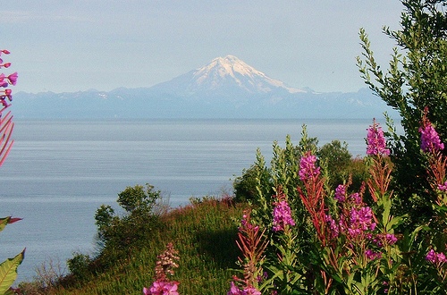
Active Volcanoes
Two prominent stratovolcanoes dominate the eastern
skyline:
Mount Redoubt (10,197 feet / 3,108 m) — a young volcano
(~880,000 years old) with a 1.8-mile-wide summit crater and the Drift
Glacier flowing from a rim gap. It erupted in 1989 (disrupting
international air traffic) and 2009 (producing lahars down the Drift
River).
Mount Iliamna (10,016 feet / 3,053 m) — similarly aged, with
extensive glacial alteration on its southern and eastern slopes, active
fumaroles producing steam plumes, and ongoing seismic activity.
These volcanoes, built on a Jurassic granite basement, exemplify the
park’s dynamic geology.
Glaciers and Glacial Landforms
Glaciers have profoundly sculpted the landscape, carving cirques,
U-shaped valleys, arêtes, and moraine-dammed lakes. The park contains
extensive ice fields and valley glaciers, many originating in the
Chigmit and Neacola ranges or on the volcanoes themselves. Wisconsin-age
glacial deposits blanket much of the terrain, and ongoing glacial
processes continue to shape valleys and deposit sediment. Glaciers act
as “rivers of ice,” grinding bedrock and transporting vast quantities of
till that form moraines and influence river braiding downstream.
Hydrology: Lakes, Rivers, and Watersheds
Lake Clark is the park’s
centerpiece—a long, linear, glacially carved lake over 40–42 miles
(64–68 km) long, up to 860 feet (260 m) deep, and covering about 128
square miles (332 km²). Its turquoise color comes from glacial silt. It
is the sixth-largest lake in Alaska and the headwaters for the Newhalen
River (fed by the Tlikakila River from Summit Lake) and ultimately the
Kvichak River system.
The park protects critical headwaters for the
Kvichak and Nushagak rivers, which flow into Bristol Bay and support the
world’s largest sockeye salmon runs. Hundreds of smaller glacial lakes,
cascading streams, and waterfalls feed a vast network of pristine
rivers. West of the mountains, rivers braid across broad outwash plains,
depositing sediment and creating dynamic floodplains. Coastal shorelines
along Cook Inlet include rocky beaches and isolated coves.
Climate
The climate is subarctic (Köppen Dfc), shaped by the
collision of Arctic and maritime air masses. This produces heavy
year-round precipitation (often exceeding 120 inches / 3,000 mm annually
in coastal and mountain areas), massive snowfall (over 150 inches / 380
cm in places), cool summers (rarely above 62°F / 17°C), and cold winters
(frequently below 0°F / –18°C). Maritime influence moderates
temperatures along Cook Inlet, while interior areas are more
continental. The result: persistent ice fields, glaciers, and complex
weather patterns that fuel the park’s dramatic hydrology and ecosystems.
Best Time to Visit
The park is open year-round, but most visitors
come between June and October, when weather is milder (though still
unpredictable), days are long, and more transportation/lodging options
operate.
June–July: Prime for bear viewing (bears foraging on
sedges or early salmon runs), wildflowers, and fewer crowds. Weather can
be cooler/wetter early on.
July–August: Peak season for fishing
(salmon runs), warmer temps, and reliable flightseeing. Berries ripen,
and wildlife is active.
September: Excellent for bear viewing (bears
fattening up for winter near falls/creeks), fall colors, and potentially
fewer bugs/mosquitoes.
May and October: Shoulder seasons with
variable weather; some services may close.
Winter access is possible
via ski planes, but it's extreme and for experienced adventurers only.
Expect rapid weather changes—pack layers, rain gear, and be flexible
with plans, as fog or storms can ground planes.
How to Get There
Access is almost exclusively by small aircraft (floatplane, bush plane,
or wheeled plane). No roads connect to or within the park.
Primary hubs: Anchorage (easiest, ~1-hour flight, scenic over Lake Clark
Pass), Homer, or Kenai.
Main entry point: Port Alsworth (on Lake
Clark's southeastern shore)—a small community with the park's visitor
center, airfield, and some lodging. Regular flights operate via
companies like Lake and Peninsula Airlines or Lake Clark Air from
Anchorage's Merrill Field.
Day trips: Floatplane tours from Anchorage
or Homer often land on lakes, beaches, or gravel bars for bear viewing,
fishing, or flightseeing.
Other areas: Coastal spots like Silver
Salmon Creek or Chinitna Bay (for bear viewing) may be reached by boat
from the Cook Inlet side or floatplane. Remote spots (e.g., Twin Lakes,
Dick Proenneke's historic cabin) require specialized floatplanes.
Book flights/lodges 6+ months in advance, especially for peak
summer—availability fills quickly. Costs vary widely (day trips
~$500–$1,000+ per person; multi-day stays higher). Check weather
forecasts obsessively, as poor conditions can delay or cancel flights.
Where to Stay
Options are rustic and limited—most are in or near
Port Alsworth or remote lodges.
Lodges: All-inclusive wilderness
lodges (e.g., farm-style or guided operations) offer meals, guided
activities (bear viewing, fishing, kayaking), and transport. Popular for
multi-day stays.
Camping: Rustic backcountry camping (no developed
campgrounds in most areas). Primitive sites near Port Alsworth or
dispersed wilderness camping (follow Leave No Trace). Permits may be
needed for some areas—check NPS.
Other: Some private cabins or
Airbnbs in Port Alsworth; limited in-park lodging. Bring or rent gear if
self-sufficient. No hotels or major facilities.
Top Things to Do
Bear Viewing: One of the highlights—brown bears forage on sedges
(June–July), fish salmon (July–September), or gather at falls. Popular
spots: Silver Salmon Creek, Chinitna Bay. Guided tours recommended for
safety.
Flightseeing: Scenic floatplane tours over volcanoes,
glaciers, mountains, and lakes—often the best way to experience the vast
landscape.
Hiking: Limited maintained trails (mostly near Port
Alsworth). Easy options include Beaver Pond loop (~3.2 miles RT),
Tanalian Falls (~4 miles RT), or Kontrashibuna Lake (~5.5 miles RT).
Moderate: Tanalian Mountain (8.6 miles RT, steep summit with epic
views). Backcountry hiking is vast but requires strong navigation
skills, bear awareness, and preparation—no cell service.
Fishing and
Kayaking: World-class salmon fishing; kayaking on Lake Clark or Twin
Lakes. Guided options available.
Other: Visit Dick Proenneke's
historic cabin (iconic wilderness homesteader site—accessible by
floatplane); berry picking; wildlife watching (moose, caribou, birds).
Essential Travel Tips and Safety
Plan Ahead Extensively: Book
everything early. Have backup plans for weather delays—bring extra food,
gear, and patience.
Pack Smart: Layers (fleece, waterproof
jacket/pants), sturdy boots, bug repellent/net (mosquitoes intense in
summer), bear spray (carry on every hike—rentals available in Port
Alsworth), food storage (bear-proof containers required), first-aid kit,
and satellite communicator/phone (no reliable cell service).
Wildlife
Safety: Bears are common—make noise on trails, travel in groups, store
food properly (NPS regulations strict). Never approach wildlife.
Weather and Terrain: Conditions change fast—rain, wind, cold even in
summer. Terrain is rugged; be prepared for no facilities.
Permits and
Rules: No entrance fee, but check NPS for backcountry permits, campfire
rules, drone restrictions (often prohibited), and food storage. Firearms
allowed per Alaska law but with restrictions.
Leave No Trace: This is
pristine wilderness—pack out everything, minimize impact.
Connectivity: Bring a satellite device for emergencies.
Budget:
Expect high costs due to flights and remoteness—day trips are cheapest
entry.