Location: Santa Cruz Department Map
Area: 4,425 km² (1,709 sq mi)
Amboró Hotel
Tel. 591 (0) 9322054
Amboró National Park (Parque Nacional y Área Natural de Manejo
Integrado Amboró) is one of Bolivia’s premier biodiversity
hotspots, located in the Santa Cruz Department at the “Elbow of
the Andes.” It covers roughly 442,500 hectares of core national
park plus a larger buffer (total protected area often cited
around 637,600 hectares). Elevations range from about 300 m in
the lowlands to over 3,300 m, creating a rare convergence of
Amazon rainforest, Yungas cloud forests, and drier
Chaco-influenced zones.
This produces exceptional richness:
over 900 bird species (around 60% of Bolivia’s total), roughly
170–180 mammal species (including jaguar, spectacled
bear/jucumari, puma, ocelot, tapir, and giant anteater),
hundreds of reptiles and amphibians, and thousands of plant
species, notably giant tree ferns, endemic orchids, and
bromeliads.
Best Time to Visit
The dry season (roughly May–October,
especially June–August/September) is ideal for most visitors. Trails
are firmer, mud is reduced, river crossings are more reliable,
mosquito pressure is lower, and conditions favor hiking, camping,
and wildlife viewing. Nights can be cooler at higher elevations.
The wet season (November–April, peaking around January) brings lush
greenery, spectacular waterfalls, active amphibians/reptiles, and
strong bird activity, but dirt roads become muddy or impassable,
unbridged streams rise quickly, and landslides or temporary
isolation are risks—particularly on the northern side. Always check
current road and trail conditions.
Getting There and Access
Rules
Most visitors base themselves in Santa Cruz de la Sierra
and travel to one of two main gateways:
South (Samaipata and
nearby): ~120 km / 2.5–3 hours from Santa Cruz on a paved road.
Ideal for cloud forests, giant ferns, day hikes, and combining with
the nearby UNESCO-listed El Fuerte de Samaipata archaeological site.
Popular entries include Los Volcanes, La Chonta, and Mataracú.
North (Buena Vista, Santa Fe, Yapacaní): ~100–120 km / 1.5–3 hours.
Better for Amazonian rainforest, rivers, and deeper immersion.
Access often requires 4WD beyond the town.
Public minibuses
and shared taxis run regularly and inexpensively (roughly Bs 20–50
one way). A private vehicle or tour transfer is more convenient.
Inside the park, dirt tracks, river crossings, and limited
infrastructure are the norm—4WD is strongly recommended outside the
driest months.
A licensed guide is mandatory by law (SERNAP
rules). Independent entry is not allowed. Arrange guides through
official associations in Samaipata, operators in Buena Vista/Santa
Cruz, or eco-lodges. This requirement protects the ecosystem and
improves safety and wildlife spotting.
Costs
Entrance fees
for foreign visitors are commonly reported in the Bs 50–100 range
(lower for Bolivians and students); confirm the current rate locally
as figures vary by source and year. Guide fees typically run Bs
200–400+ per day depending on group size, route, and duration. Day
tours from Samaipata or Santa Cruz often start around the equivalent
of $30–80 USD per person (cheaper in groups); multi-day packages
with transport, meals, and lodging commonly fall in the $100–250+
range. Cash (bolivianos) is essential—ATMs are scarce near the park.
Key Activities and Experiences
Hiking and cloud-forest
immersion: Trails through giant fern forests (prehistoric-looking
tree ferns), orchid-rich areas, and viewpoints. Popular options
include routes from Los Volcanes (e.g., toward Filo de la Neblina or
giant-fern sectors), La Yunga, and shorter circuits. Expect variable
difficulty, humidity, and occasional steep or slippery sections.
Birdwatching: Exceptional. Target military macaws, helmeted
curassows, toucans, cock-of-the-rock, hummingbirds, and raptors
including Andean condors in higher zones. Early morning and late
afternoon are best; binoculars are highly recommended.
Wildlife
watching: Mammals are elusive in dense forest. Guides help spot
tracks, calls, and occasional sightings of monkeys, coatis, or (with
luck) larger species near water sources. Night walks can reveal
amphibians, reptiles, insects, and nocturnal mammals.
Waterfalls
and rivers: Swim in natural pools, visit cascades, and enjoy
riverside trails (conditions vary sharply with season).
Multi-day
options: Camping or stays at community-run eco-lodges/refugios
(e.g., Refugio Los Volcanes on the south, La Chonta or Mataracú-area
options on the north) for deeper immersion, night safaris, and local
cultural interactions.
Cultural pairing: Combine with El Fuerte
de Samaipata for pre-Inca rock carvings and archaeology.
Infrastructure inside the park is limited—expect basic facilities,
limited or no cell service in the interior, and self-sufficiency for
water/snacks on longer hikes.
What to Pack
Sturdy,
broken-in waterproof hiking boots with good grip (trails are often
muddy or slippery).
Lightweight, quick-dry layers (long
sleeves/pants for insects and sun), rain jacket, and a warm layer
for higher elevations or nights.
Insect repellent with DEET,
sunscreen, hat, and sunglasses.
Binoculars, camera (in dry bags),
headlamp, basic first-aid kit, and water purification or sufficient
bottles.
Cash, passport copies, and any medications.
Biodegradable products where possible.
Health and Safety
Consult a travel doctor about vaccinations and malaria
prophylaxis—risk exists in lower, more Amazonian sectors and varies
by season. Drink treated or bottled water. Stick strictly to marked
trails and your guide’s instructions. Inform someone of your
itinerary. In the rainy season, monitor weather for rising rivers
and landslides. The park is generally quiet in tourist zones, but
remote areas have limited rescue options.
Accommodation and
Logistics Tips
Base in Samaipata (hostels to eco-cabins, good
food and tour options) or Buena Vista for easier access. Inside or
near the buffer zone, choose community eco-lodges or tent camps for
authenticity. Book peak-season (June–August) stays and guides ahead.
Support local guides and communities—they are essential to
conservation.
Responsible travel: Stay on trails, carry out all
waste, do not feed or approach wildlife, and hire authorized local
guides. The park faces pressures from deforestation, fires, and
illegal activity in remote zones; responsible tourism helps
demonstrate the value of intact forest.
Topography and Elevation
The park is predominantly mountainous,
with steep slopes, deep canyons and gorges, narrow valleys, and
pronounced relief. Elevations range from roughly 300 m (about 980 ft) in
the lowest northern and eastern lowland/alluvial zones to a maximum of
about 3,338 m (10,951 ft) in the westernmost high sector known as
“Siberia.” Most of the park lies between 1,000 m and 2,000 m. Some
sources list slightly different peak figures for named summits (e.g.,
Cerro Calizonudo near 2,726 m in certain inventories), but the
300–3,300+ m span is the standard cited range.
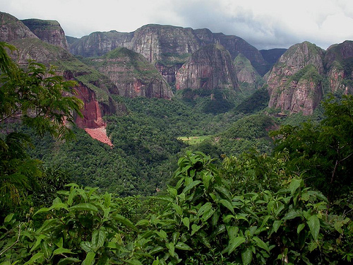
Southern sectors
feature striking red sandstone buttes, cliffs, and massifs (notably in
areas like Los Volcanes / Serranías del Amboró), creating dramatic
vertical rock faces above forested valleys. The overall physiography is
highly dissected, producing sharp transitions in aspect, slope, and
local microclimates. Alluvial plains occur in the north and along major
rivers, while the central and western zones are dominated by steep
montane terrain. This vertical and topographic diversity is a primary
driver of the park’s exceptional ecological heterogeneity.
Climate and Precipitation
Climate varies strongly with elevation,
exposure, and north–south position. Higher zones are temperate (with
possible frosts in the coldest months); lower foothills and lowlands are
warm to hot and humid. Temperatures commonly range from around 12°C at
altitude to the mid-20s°C lower down, with seasonal peaks higher in the
austral summer.
Annual rainfall is highly variable, typically cited
from about 1,400 mm to 4,000 mm (and in some southern or drier pockets
lower, around 600–1,000 mm). The north and higher-rainfall Yungas belts
are much wetter; the south is comparatively drier. The regime is broadly
biseasonal, with the heaviest rains generally in the warmer months.
Orographic effects and the “elbow” geography intensify precipitation on
windward slopes while creating rain-shadow contrasts. These gradients
produce sharp ecotones—often visible over short distances—between wet
cloud forests and drier formations.
Ecosystems and Ecoregions
Amboró sits at the confluence of several major bioregions and
ecoregions, including Southwest Amazon moist forests, Yungas (humid
montane and cloud forests), Bolivian montane dry forests, elements of
Dry Chaco, and Chiquitano dry forests. This meeting of Amazonian,
Andean, and drier subtropical influences is rare and underpins the
park’s extreme biodiversity.
Management and vegetation
classifications recognize distinct zones tied to topography and
elevation:
Seasonal evergreen wet forest on nearly flat alluvial
plains with recent Quaternary sediments.
Piedmont wet forest on
undulating low hills and narrow valleys.
Sub-Andean rainforest in
transitional, well-drained slopes between plains and mountains.
Humid
montane Yungas forest (the best-represented type), with steep slopes,
wider alluvial valleys, and deep quebradas.
Cloud forest / “ceja de
yunga” on higher ridges and peaks (often 3,000–3,100 m), frequently
cloud-enveloped, with epiphytes, bromeliads, orchids, and tree ferns.
Dry inter-Andean valleys in the south, with partially flat topography
and colluvial/fluvio-lacustrine soils.
Additional formations
include palm forests, tree-fern forests, cactus and scrub communities,
riparian woodlands, and pampas-like openings. Giant tree ferns are a
notable feature in wetter montane areas. Vegetation boundaries are often
abrupt because of elevation and aspect changes, producing a mosaic
landscape.
Hydrology and Watersheds
All major drainage
ultimately feeds the Amazon system via the Mamoré River. Principal
watersheds include the Ichilo (western drainage), Yapacaní (covering a
large share of the park, over 60% in some assessments), and Río Grande
(southwestern). Key rivers and tributaries include the Yapacaní, Surutú,
Ichilo, and others that rise in or cross the park; the Piraí River
system, important for Santa Cruz water supply, has headwaters linked to
the broader Amboró region.
Rivers are often torrential, carving deep
canyons and feeding numerous waterfalls. The hydrographic network
creates a varied geomorphology of floodplains, natural levees, gorges,
and cliffs. The park’s forests play a significant hydrological role:
they protect headwaters, regulate runoff, and contribute moisture via
evapotranspiration to regional “flying rivers” that help sustain
precipitation farther west in the Andes. Watershed protection is a core
conservation objective given the high rainfall and steep topography.
Geographic Significance for Biodiversity and Landscape
The
combination of elevational range (over 3,000 m), dissected relief, high
and variable rainfall, and position at the Andes–Amazon–Chaco interface
produces one of the world’s more extreme cases of compressed ecological
diversity in a relatively compact area. Ecotones are sharp, endemism is
high, and many remote sectors remain incompletely surveyed. Scenic
highlights include cloud-shrouded ridges, giant-fern stands, red
sandstone formations, cascading rivers, and the contrast between lush
northern Yungas/Amazonian-influenced zones and drier southern valleys.
The park also forms part of the broader Vilcabamba–Amboró biological
corridor.
Flora
Approximately 3,000 higher plant species are documented,
with estimates of 3,500–5,000 total (many areas remain poorly surveyed
due to rugged terrain). This is exceptionally high for the park’s
size—comparable or higher than far larger regions with better-studied
floras.
Vegetation types shift rapidly with elevation and aspect:
Lowland and foothill humid forests feature tall emergents, palms
(including açaí/Euterpe precatoria and pachiuva), and economically
important trees such as bigleaf mahogany (Swietenia macrophylla, locally
mara—threatened by logging), mountain pine (Podocarpus spp.), and black
walnut (Juglans boliviana). Other notable species include pacay (Inga
velutina), bibosi (Ficus spp.), ambaiba (Pourouma spp.), and guitarrero
(Didymopanax/Schefflera morototoni).
Cloud and montane Yungas forests
(often above ~1,000–1,500 m) are characterized by dense epiphyte loads
of orchids (at least 500 species recorded, many endemic), bromeliads,
mosses, and ferns. Extensive stands of giant tree ferns (Cyathea and
Alsophila/Alsophyla species) form cathedral-like groves, some reaching
10–13 m; these are especially prominent in southern cloud-forest zones
near places like La Yunga de Mairana. These fern forests evoke a
prehistoric landscape.
Drier and transitional zones include montane
scrub, cactus forests in inter-Andean valleys, and elements of
Chiquitano/Chaco dry forest.
Other mentioned species include
limachu (Myrsine coriacea), q’illu q’illu/khellu khellu (Berberis or
related, e.g., Bocona frutescens in some lists), cebillo (Myrica
pubescens), clavo rojo (Palicourea), and canelón (Aniba). High endemism
is expected, particularly in isolated ridges and cloud-forest pockets.
The park protects significant genetic resources of tropical timber
species under commercial pressure elsewhere.
Fauna
The park
holds exceptional faunal diversity, driven by the same habitat mosaic.
Mammals number around 136–177 species (sources vary; Wikipedia cites
177), including 43 bat species. Large and charismatic species include:
Spectacled bear (Tremarctos ornatus, locally jucumari)—the only South
American bear, Endangered, an ecological and cultural keystone that
ranges from cloud forests to lower elevations.
Jaguar (Panthera
onca), puma (Puma concolor), ocelot (Leopardus pardalis), and other
small cats.
Giant anteater (Myrmecophaga tridactyla), giant armadillo
(Priodontes maximus), lowland tapir (Tapirus terrestris), brocket deer
(Mazama spp.), peccaries, and various monkeys (including spider monkeys
in Amazonian sectors).
High diversity of rodents, marsupials, and
carnivores. Otters occur along rivers.
Birds total 800–912+
species (over 60% of Bolivia’s avifauna), making Amboró one of the
richest single protected areas for birds on the planet and a premier
birdwatching destination. Notable species include the horned/southern
helmeted curassow or stone-crested guan (Pauxi unicornis, Endangered and
of global importance for the site), military macaw (Ara militaris),
red-fronted macaw (Ara rubrogenys), harpy eagle (Harpia harpyja),
cock-of-the-rock, and many endemics or range-restricted species.
Hummingbirds, trogons, tanagers, macaws, and mixed flocks are abundant
across elevations; the park supports both resident and migratory
species.
Amphibians and reptiles show particularly high richness and
endemism: roughly 173 amphibian species (including ~50 toad species
alone) and 105–135 reptile species (about half of Bolivia’s known
reptiles in some counts). The park is a global Key Biodiversity Area
partly due to threatened endemic amphibians (e.g., certain Gastrotheca,
Telmatobius, Psychrophrynella/Microkayla, and Oreobates species).
Reptiles include caiman (Caiman yacare), boa (Boa constrictor),
bushmaster (Lachesis muta), and various lizards and snakes.
Other
groups:
Fish: ~109 species, strongly altitude-dependent. Larger
commercial/subsistence species such as sábalo (Prochilodus), surubí
(Pseudoplatystoma), and pacú (Piaractus) are mainly in lower alluvial
zones below ~700 m; diversity drops sharply above 1,000 m.
Invertebrates: At least 289 species of day-flying butterflies (highest
recorded for any Bolivian park), with high diversity expected among
beetles, orchid bees, spiders, scorpions, and others.
Ecological
and Conservation Context
The park’s biodiversity stems directly from
its position at the Amazon–Andes–Chaco interface and the steep gradients
that compress multiple life zones into short distances. Cloud forests
and Yungas are especially species-rich for epiphytes, amphibians, and
birds. Giant tree-fern groves and orchid-rich canopies are scenic
highlights, while the presence of top predators (jaguar, harpy eagle)
and large herbivores/omnivores (tapir, spectacled bear) indicates
relatively intact trophic structure in core areas.
Threats include
illegal logging (especially mahogany), hunting, agricultural
encroachment, mining, and occasional illicit coca cultivation; park
boundaries and the distinction between strict National Park and
Integrated Management zones have been contentious. Access is primarily
from the north (Buena Vista, Yapacaní) and south (Samaipata, Mairana,
Comarapa), with guided entry required. Key visitor sites include
giant-fern forests, waterfalls (e.g., Macuñucú), and cloud-forest
trails.