Location: 140 km south of Cochabamba, Northern Potosí Department Map
Area: 165 km²
Torotoro National Park (Parque Nacional Torotoro / Toro Toro),
in northern Potosí department, is one of Bolivia’s most
distinctive and underrated protected areas. Covering about 165
km² at elevations roughly 2,000–3,700 m, it combines Cretaceous
dinosaur trackways, deep limestone canyons with waterfalls and
swimming pools, extensive cave systems, and eroded rock
formations. The small village of Torotoro (around 2,600–2,700 m)
sits at the center and serves as the base.
A major 2025–2026
paleontological study documented roughly 16,600 theropod (and
related) footprints at the Carreras Pampa site alone—one of the
world’s densest and most extensive dinosaur track sites—along
with swim tracks, tail marks, and later finds of Cretaceous
turtle tracks. These sit on tilted limestone bedding planes once
shorelines or wetlands.
Access is practical only from
Cochabamba (about 140 km / 3–6 hours depending on road
conditions and vehicle). The park is managed by SERNAP with
strong local community involvement; guiding is mandatory for the
main circuits.
Main Circuits and Attractions
Activities are organized as guided
circuits (typically half-day to full-day). All require a licensed local
guide from the association; independent hiking on the main sites is not
permitted.
Dinosaur tracks + El Vergel / Torotoro Canyon
(classic, moderate): Starts near the village at sites such as Carreras
Pampa and slopes below Cerro Wayllas, where thousands of theropod,
sauropod, and other Cretaceous footprints are visible on open rock (no
glass cases). Continues along the canyon rim to viewpoints, then
descends a long staircase (commonly cited around 800 steps, roughly 40
minutes down) into a ~250–300 m deep canyon to El Vergel waterfall and
clear pools at the bottom. Swimming is popular when water levels allow.
The climb back is the strenuous part (knees and heat matter). Condors
and vultures are often seen on thermals. Half-day to full-day; start
early.
Umajalanta Cave (moderate, confined spaces): One of Bolivia’s
longest and deepest cave systems (~4–4.6 km explored, significant
depth). Features stalactites, stalagmites, an underground river, and
endemic blind fish (Trichomycterus chaberti). Not a show cave—expect
crawling, ducking, tight squeezes, wet and slippery limestone, and about
2–2.5 hours inside. Helmets and lights are provided (small fee).
Unsuitable for claustrophobia. Often combined with transport and Ciudad
de Itas.
Ciudad de Itas (easy physically): High plateau (~3,600–3,700
m) of eroded rock formations resembling a stone city, with arches,
caverns, and some rock paintings. Mostly driving plus shorter walking;
photogenic and good for views. Usually paired with the cave because both
need vehicle transfer (~1 hour from the village).
Other options
(longer or less visited): Chiflón Qaqa, mushroom-shaped rocks,
additional canyon walks, rock art, and archaeological sites such as
Llama Chaqui (Quechua remnants). These can require a spare day and a
good guide.
Guides explain the geology and paleontology; quality
varies, so ask about experience or form groups early at the office. Most
guides speak Spanish; English is limited.
Getting There and
Logistics
From Cochabamba: Shared minibuses/colectivos leave from the
south of the city (around Avenida República and Valle Grande / related
points). Cost roughly Bs 35 each way; they leave when full (often
morning departures, but variable). Journey 3–6 hours (improved road
sections help in dry conditions; rainy season lengthens it or can make
sections difficult). Private transfers or organized multi-day packages
(transport + lodging + guides) are available and easier if you prefer
not to coordinate yourself. Return options exist through the day.
From La Paz or elsewhere: Fly or bus to Cochabamba first (short domestic
flights common), then continue. No practical direct public option from
Sucre/Potosí.
Charter plane: Occasional small-plane options from
Cochabamba (higher cost, limited capacity).
Fees (approximate
2026 figures; confirm on arrival): Park entry ~Bs 100 per person (valid
several/4 days; student discounts sometimes available). Guides ~Bs
100–160 per circuit per group (typically capped around 6 people—so
splitting with others is essential for cost). Vehicle transport for
outlying sites ~Bs 150 per group. Caving gear ~Bs 10–15. No ATM in
Torotoro—withdraw cash (bolivianos) in Cochabamba for entry, guides,
lodging, food, and transport. Bring a margin.
Register at the
SERNAP/tourist office in town and hire guides next door (Casa de las
Guias or equivalent). Arrive early (around 7 a.m.) to form groups and
secure the day. Tickets get stamped at major sites.
Best Time to
Visit
Dry season (roughly May–October, especially May–September) is
best for reliable road access, firm trails, open caves, and lower rain
risk. Clear skies favor condor viewing. Waterfalls and pools are
weaker/shallower and colder. Wet season (November–March/April) brings
greener landscapes and stronger waterfalls but higher risk of muddy
roads, delays, slippery trails, and temporary closures (especially the
cave or canyon due to water levels). Add buffer days if traveling then.
Altitude in the village is milder than the Altiplano (good for
acclimatization before Uyuni or La Paz), but Ciudad de Itas is higher
and nights are cool.
Recommended Time and Sample Itinerary
Minimum practical stay is 2 days / 1 night (covers two main circuits); 3
days / 2 nights is more comfortable and allows all primary sites plus
weather buffer. One day is unrealistic due to travel time.
Typical
independent plan:
Arrive morning/afternoon → afternoon dinosaur
tracks + canyon.
Next morning: Umajalanta + Ciudad de Itas (or
reverse).
Optional third day for longer routes or relaxed village
time; return mid-afternoon.
Organized 2D/1N or 3D packages from
Cochabamba handle logistics (higher cost but convenient, especially
without Spanish).
Practical Tips and Packing
Cash,
connectivity, language: No ATM, limited/spotty signal or internet.
Spanish helpful for guides and logistics.
Gear: Sturdy hiking
shoes/boots with grip (slippery limestone and stairs), layers (cool
nights and higher elevations; warm jacket), sun protection (hat,
sunglasses, sunscreen—strong UV), plenty of water, snacks, quick-dry
clothes (you will get dirty/wet in the cave), headlamp (stronger than
basic provided ones is useful), basic first-aid/toilet paper, poles
optional for knees on the canyon stairs. Swimwear and towel for El
Vergel if conditions allow. Old clothes for caving.
Physical notes:
Canyon stairs are the main fitness demand at ~2,700 m. Cave requires
flexibility and comfort in confined spaces. Hydrate and consider coca
tea for mild altitude.
Village life: Simple guesthouses/hostels (Bs
60–150+ basic; mid-range higher; hot water variable). Market and
comedores for inexpensive meals (set plates ~Bs 10). Friendly,
small-town atmosphere with basic shops. Community lodges exist in some
areas.
Conservation: Do not touch, stand in, or mark the footprints.
Stay on guided routes. The community-guided model channels income
locally and protects the sites.
Other: Motion sickness possible on
the road. Facilities outside the village are minimal. Respect local
communities.
Location and Regional Setting
The park occupies the northern tip
of Potosí in the transition zone between the Eastern Cordillera of the
Andes and the Río Grande/Amazon basin. It sits in the “Elbow of the
Andes” region among inter-Andean dry valleys (valles secos mesotérmicos
or Prepuna biogeographic subregion). The surrounding landscape is
mountainous with deep canyons, valleys, and waterfalls. Access is
primarily via the Cochabamba–Anzaldo–Torotoro route (passing the Río
Caine); secondary routes exist from Oruro direction. The town of
Torotoro (founded roughly 250 years ago by Quechua and Spanish settlers)
sits inside or adjacent to the park at around 2,600–2,700 m and serves
as the visitor hub. Ten rural communities and the urban center coexist
within or near the protected area.
Topography and Physiography
Elevations range from approximately 1,900 m to 3,600 m above sea level
(commonly cited as 2,000–3,500 m). The terrain is characteristically
mountainous and dissected: deep canyons (up to ~300 m / 980 ft), steep
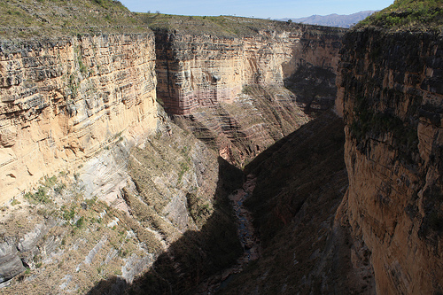
cliffs, plateaus, hills, and valleys. The standout feature is the
Torotoro Canyon (and the connected El Vergel / Huacasenq’a area), with
sheer layered walls and a descent of hundreds of stairs to waterfalls
and natural pools. Higher zones include Andean puna grasslands and
eroded rock formations (e.g., Ciudad de Itas at higher elevations near
3,700–4,000 m in the broader area). Wind, water, and past glacial
processes have sculpted the surface.
The landscape is structured by
the Torotoro-Caine synclinorium, a Pliocene–Pleistocene fold-and-thrust
feature from Andean orogeny. This produces a diversified set of geoforms
from the dissection of karstic and clastic sequences.
Geology and
Geomorphology
The park has a complex geological history spanning the
Paleozoic, Mesozoic, and Cenozoic. Paleozoic units include Ordovician
through Permian sedimentary rocks (intensely deformed, with marine
fossils). The Mesozoic is dominated by Cretaceous formations (Torotoro,
La Puerta, Miraflores, Chaunaca, El Molino, Santa Lucía and related),
which form the characteristic syncline and host abundant fossils and
tracks. Cenozoic and Quaternary deposits include alluvial, colluvial,
and terrace materials along rivers.
Key processes include Andean
tectonics (synclines, anticlines, faults, fractures, discordance),
karstification of limestones (producing caves, dolines, and underground
drainage), and erosion by wind and water. The park is especially noted
for its speleology: more than 60 caves and galleries (Umajalanta /
Humajalanta is Bolivia’s deepest and one of its longest systems, with
explored passages of several kilometers, stalactites/stalagmites, and an
underground river). Other notable caves include Chiflón Qaqa and Huaca
Senka. The area is under consideration or has been evaluated for UNESCO
Global Geopark status due to this integrated geological,
paleontological, and landscape record.
Paleontologically, it is one
of Bolivia’s premier sites. Cretaceous (especially Late Cretaceous /
Campanian–Maastrichtian) rocks preserve thousands of dinosaur footprints
and trackways (earlier estimates of 2,500–3,500+; recent detailed work
at sites such as Carreras Pampa has documented far larger numbers,
including major theropod assemblages). Tracks represent bipedal and
quadrupedal dinosaurs (theropods, sauropods, ankylosaurs, ornithopods
and others). There are also bone fragments, marine invertebrates, fish,
turtles (including notable concentrations), and other fossils from
coastal/marine and terrestrial environments when the region was a
shallow marine or wetland setting roughly 70–120 million years ago.
Tracks are often on tilted sedimentary beds (mudstone, sandstone,
limestone).
Climate
The climate is temperate/mesothermic and
predominantly semi-arid to dry (Köppen class B, dry steppe), with strong
altitudinal variation. Annual precipitation is typically under 600 mm in
lower and mid zones (sometimes cited below 450 mm near the Río Caine;
mid-elevation 450–650 mm; higher elevations can reach 800–1,000 mm).
Rain concentrates in December–March (rainy season); the dry season runs
roughly April–October, with very low rainfall and clearer conditions
(preferred for visitation, May–October).
At the Torotoro
meteorological station (~2,700 m), mean monthly temperatures range about
14–21 °C (annual mean ~16–18 °C), with daytime highs often 15–22 °C and
extremes rarely exceeding ~31 °C or dropping below 0 °C. Temperature
decreases with elevation; higher zones are cooler and foggier in summer.
Winds are significant, especially from eastern directions.
Hydrology
The park drains to the Amazon basin via the Río Caine (the
most important regional river, forming a departmental boundary in places
and originating farther north in Cochabamba) and the San Pedro system,
with multiple sub-basins. Within the park, the Río Torotoro and
tributaries such as the Umajalanta and Chiflón Qaqa are key; some
stretches flow underground through caves. There are waterfalls, natural
pools (notably at El Vergel), and hundreds of springs, streams, and
temporary watercourses. Permanent flow is more reliable on major
tributaries of the Caine.
Biogeography, Flora, and Fauna
Biogeographically, it lies in the Neotropical realm (Andean region),
spanning Prepuna and elements of Peruvian/Bolivian-Tucuman provinces,
with dry deciduous inter-Andean valley forests as the main ecoregion.
This creates a mosaic of xeromorphic scrub and grasslands, dry forests,
relict subhumid pre-puna woodlands, and higher queñua patches. Human use
over centuries (agriculture, grazing, fire) has left many secondary or
modified communities.
Flora records show roughly 329–359 vascular and
non-vascular plant species, with at least 20 endemic to Bolivia (some
strictly local). Characteristic elements include xerophytic shrubs,
cacti, queñua (Polylepis spp.), quebracho blanco (Aspidosperma
quebracho-blanco), soto (Schinopsis), and remnant mountain pine
(Podocarpus). Higher slopes support sparse Polylepis woodlands.
Fauna
is diverse for the setting, with high endemism and threatened species.
Birds number around 119 species (~8% of Bolivia’s avifauna), including
the endemic and threatened red-fronted macaw (Ara rubrogenys / paraba
frente roja), Andean condor, cliff parakeet, and others. Mammals (~64
species) include Andean fox, puma, Andean cat (titi), taruka (Andean
deer), viscachas, rodents, and numerous bats that use the caves.
Herpetofauna includes amphibians and reptiles with significant endemism
and threatened forms. A notable specialty is the endemic blind catfish
Trichomycterus chaberti in the Umajalanta cave system. Overall, the park
protects species adapted to dry inter-Andean and Andean environments,
though many populations face pressures from habitat change and hunting.