Location: Arica-Parinacota Region Map
Area: 1,379 km²
Lauca National Park (Parque Nacional Lauca) is one
of Chile’s most dramatic high-altitude destinations, set in the
Altiplano of the Arica y Parinacota Region in the far north. It
protects roughly 137,883 hectares of volcanic landscapes, wetlands,
and wildlife at elevations typically from about 3,200 m to over
6,300 m. Established as a national park in 1970, it forms part of
the larger Lauca Biosphere Reserve (UNESCO-recognized in 1981 and
later expanded).
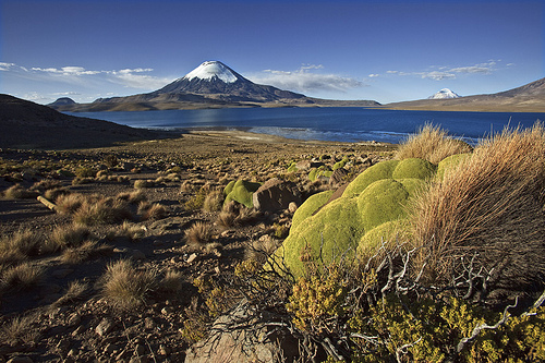
The scenery centers on Lago Chungará (one of the
world’s highest sizable lakes, around 4,500–4,517 m), the twin
Payachata volcanoes (Parinacota at about 6,342 m and Pomerape),
interconnected Lagunas Cotacotani, bofedales (high-altitude
wetlands), and herds of vicuñas against snow-capped peaks.
Location, Access, and Getting There
The park lies about 145–160 km
(roughly 3–4 hours) east of the coastal city of Arica along the paved
international Ruta 11-CH (Arica–La Paz highway), which crosses the park.
Putre (around 3,500 m) is the main gateway town, roughly 30–45 minutes
before the higher park sectors.
By car: Rent in Arica (airport or
town). The road is paved but involves a steep, winding ascent; ensure
the vehicle is in excellent condition, carry spare fuel (no stations
between Arica and the park or inside it), and check tires, brakes, and
cooling systems. High-altitude driving can feel different due to thinner
air.
By tour: The most practical option for most visitors. Full-day
tours from Arica are common (early departure, return evening); multi-day
options allow better pacing. Tours from Putre are also available and
often preferable after acclimatization. Many include a guide, oxygen,
and sometimes meals.
By bus: Limited public transport reaches Putre
(e.g., services from Arica); from there you generally need a tour or
private transfer into the park itself.
Entry is free with no
controlled gate or fixed hours in the usual sense, though CONAF rangers
are present and facilities have practical limits. Access can be affected
by weather, especially during the Bolivian Winter.
Best Time to
Visit and Weather
The park is visitable year-round, but the dry
season (roughly April/May through November/December) is strongly
preferred for clearer skies, more stable weather, and better road
conditions. Daytime temperatures are cool (often 0–15 °C or so at higher
elevations), while nights drop well below freezing.
December–March (Bolivian Winter / invierno altiplánico): Higher chance
of afternoon storms, rain, lightning, and temporary road or access
issues. Still possible but less ideal; monitor forecasts and avoid the
area during poor weather.
June–August: Clear days but the coldest
nights; excellent for snow-capped volcano views if properly equipped.
Shoulder seasons (spring and autumn) often combine milder conditions
with fewer visitors.
Intense UV, strong winds, and rapid
temperature changes are constant. There are no extensive visitor
facilities inside the park.
Altitude and Acclimatization
(Critical)
Most highlights sit near or above 4,000–4,500 m. Acute
mountain sickness (soroche/puna) is common if you ascend too quickly
from sea level. Symptoms include headache, nausea, fatigue, and
shortness of breath.
Recommended approach:
Spend at least one
night (ideally 1–2) in Putre (~3,500 m) to acclimatize before going
higher to Chungará or Cotacotani.
Ascend slowly, walk gently, avoid
sudden bending or heavy exertion on the first day at altitude.
Hydrate constantly; eat light meals; avoid alcohol.
Coca tea or
chachacoma (local herbal) is traditionally used; some people consult a
doctor about acetazolamide (Diamox).
Day tours from Arica carry a
higher risk of symptoms; many operators carry supplemental oxygen.
Descend immediately if symptoms worsen.
Move slowly and respect your
limits—the scenery rewards a measured pace.
Key Attractions and
Activities
Lago Chungará: The iconic mirror-like lake with
reflections of Parinacota and Pomerape. Excellent for photography at
first light or late afternoon. Short easy trail (~600 m, ~30 minutes).
Abundant birds including flamingos.
Lagunas Cotacotani:
Interconnected lagoons and bofedales with shifting light and rich
birdlife; highly photogenic.
Parinacota village: Small colonial-era
settlement with a historic church (national monument); Aymara cultural
presence.
Wildlife viewing: Vicuñas and guanacos are frequently seen
grazing; three species of flamingos (Chilean, Andean, James’s); Andean
geese, giant coots, suri (rhea), vizcachas, Andean foxes, and occasional
taruca or puma (rare). Mornings and late afternoons are best. Bring
binoculars. Over 60–140 bird species have been recorded in the broader
area.
Practical Visiting Tips
Packing: Layered clothing
(thermal base, fleece, windproof/waterproof shell), warm hat, gloves,
sunglasses, wide-brimmed hat, and high-SPF (50+) sunscreen plus lip
balm. Sturdy walking shoes. Plenty of water, snacks, and a camera.
Temperatures swing dramatically.
Services: Extremely limited inside
the park. Fuel, food, and lodging are mainly in Putre or Arica. Carry
everything you need.
Rules and respect: No fires, camping stoves,
smoking, alcohol, pets, or drones (without prior CONAF authorization).
No littering—pack it out. Stay on trails. Do not feed or approach
wildlife. Respect Aymara communities and private property; ask before
photographing people.
Safety: Check weather and road conditions
(especially summer). Vehicle must be reliable. Lightning risk in storm
season. Limited cell signal in places. Rangers and CONAF offices can
provide updates (contact via aricayparinacota.oirs@conaf.cl).
Timing:
Start early for the best light, calmer conditions, and more active
wildlife. A full day from Arica is long (9–10+ hours round-trip);
overnighting in Putre is better.
Budget notes: Free park entry. Day
tours from Arica often start around the equivalent of €90–100+ per
person depending on inclusions and operator; multi-day options cost
more. Putre lodging ranges from basic hostales to more comfortable
lodges.
Suggested Approach
Arrive in Arica and either book a
day tour or drive/bus to Putre.
Overnight in Putre to acclimatize.
Explore Chungará, Cotacotani, and Parinacota at a relaxed pace the next
day (self-drive if prepared, or guided).
Optionally extend for more
wildlife time or nearby sites.
Relief and Volcanic Geology
The terrain is highly irregular and
dominated by large stratovolcanoes of the Central Volcanic Zone of the
Andes. The most prominent are the twin Payachata volcanoes on the
Chile–Bolivia border:
Parinacota (6,342 m / 20,807 ft), a
near-perfect cone with a permanent snow and ice cap.
Pomerape (6,282
m / 20,610 ft), its slightly lower twin.
Other major peaks
include Guallatiri (~6,060 m) and Acotango (~6,050 m). These volcanoes
rise abruptly from the plateau and are surrounded by lava fields,
volcanic calderas, and extensive volcanic deposits. The landscape mixes
broad, relatively flat altiplano surfaces (typically 4,000–4,500 m) with
steep volcanic slopes and rocky ridges.
Hydrology and Wetlands
Water features are concentrated in a relatively small lacustrine zone at
the base of the Payachata group. The standout is Lake Chungará (Lago
Chungará), one of the highest significant lakes in the world. It lies at
approximately 4,517 m, covers about 22.5 km², and reaches a maximum
depth of around 40 m. Its clear, often turquoise-to-emerald waters
reflect the snow-capped volcanoes. Nearby are the interconnected
Cotacotani lagoons, a complex of smaller lakes and wetlands.
The park
also contains the headwaters of the Lauca River. High-altitude wetlands
known as bofedales (cushion-plant peatlands fed by constant seepage and
springs) form green oases amid the arid plateau; the Parinacota bofedal
is especially well-known. These wetlands contrast sharply with the
surrounding dry steppe and support much of the park’s biodiversity.
Climate
The climate is a high-Andean (puna) type, strongly
influenced by altitude and the Bolivian High. Precipitation is modest
(roughly 280–390 mm annually) and strongly seasonal, falling mainly as
summer rain during the “invierno altiplánico” (Altiplano winter,
December–March), when moist air from the Amazon reaches the plateau.
Winters bring occasional snow at higher elevations. Daytime temperatures
typically range from 12–20 °C; nights drop sharply to –3 °C to –10 °C or
lower. Intense solar radiation, low humidity, and strong winds are
characteristic. The combination produces a harsh but visually dramatic
environment with clear skies and vivid light for much of the year.
Vegetation Zones and Landscape Character
Two broad elevational
zones shape the vegetation and visual geography:
Precordillera
(roughly 3,200–3,800 m): Lower slopes support sparse low shrubland (tola
and other species) and stands of queñoa (Polylepis trees), the world’s
highest-elevation trees, which grow in sheltered ravines and slopes.
Altiplano (above ~3,800 m): Dominated by dry bunchgrass steppe (Festuca
orthophylla, Deyeuxia, etc.) interspersed with bofedales. On rocky,
higher ground appear cushion plants such as llareta (Azorella compacta)
and additional Polylepis (including P. tarapacana).
The overall
landscape is one of extreme contrast: vast open puna grasslands in ochre
and pale gold, vivid green wetland cushions, deep-blue lakes, and the
stark white of snow-capped volcanic cones under intense high-altitude
light. Human presence is limited; the small Aymara village of Parinacota
(with its colonial church) sits inside the park, and the international
highway CH-11 crosses the area, providing the main access.