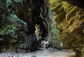
Location: Morona- Santiago province
Cueva de los Tayos (Cave of the Oilbirds) is a demanding multi-day
expedition in the Ecuadorian Amazon, not a casual day trip. The
famous system lies in Morona Santiago province on Shuar territory of
the Kuankus (Coangos) community in the Cordillera del Cóndor, near
the Coangos and Santiago rivers. Access is tightly controlled;
independent visits are impractical and not permitted without local
authorization.
It is named for the tayos (oilbirds, Steatornis
caripensis), nocturnal fruit-eating birds that roost and nest in
deep caves and navigate by echolocation. The main entrance is a
roughly vertical shaft (commonly reported 55–74 m / about 180–240 ft
depending on the exact descent point and operator), opening into
several kilometers of passages, large chambers (one reported around
90 × 240 m), waterfalls, rivers, and formations. Roughly 4.6–5+ km
have been mapped; it is among Ecuador’s longest known cave systems.
The 1976 British-Ecuadorian expedition (organized by Stan Hall and
including Neil Armstrong) mapped sections, documented burials, and
found no evidence of the “metal library” or lost city claimed by
János Móricz and popularized by Erich von Däniken. Shuar people have
long used the cave (traditionally including seasonal oilbird
collection) and regard it as culturally significant.
Note:
Multiple oilbird caves exist in the Ecuadorian Amazon. Confirm you
are booking the Coangos/Kuankus system associated with the famous
expeditions rather than more accessible sites (for example near the
Puyo–Macas road).
Location and How to Reach It
Gateway towns are Santiago de
Méndez or Limón Indanza. There is no road to the cave entrance.
Typical sequence from a major city:
Bus to Macas (about 8
hours from Quito) or via Cuenca (Gualaceo/Limón route) to
Méndez/Limón Indanza.
Road transfer to a river port such as
Puerto Yuquianza.
Canoe/boat on the Namangoza/Santiago/Yuquianza
river system.
3–4 km (or longer, depending on conditions and
starting point) muddy jungle trail with steep sections, heat (often
30–34 °C / 86–93 °F), humidity, and heavy packs. Elevation is
roughly 300–620 m, with the cave mouth around 500–550 m.
From
major cities plan at least 3 full days for the expedition itself
plus travel time. Operators usually meet in Macas, Méndez, or Limón
Indanza. Cell and internet service disappear once you leave the main
roads.
Tours, Costs, and Logistics
A Shuar community guide
(or an operator working directly with the community) is required.
Hiring them is how permission is obtained. Reputable operators
include Tayos Expeditions (based in Limón Indanza; specialized in
caving/canyoning), operators via cuevatayos.com, Samay Geotouristic,
and local Shuar guides. Book in advance; group sizes are limited
because each person takes significant time on the ropes.
Typical
format is 3 days / 2 nights: one night with the community or at a
shelter, one night camping inside the cave. Some operators offer
variations or private trips.
Approximate costs (recent reports,
roughly 2025–2026): USD 230–350+ per person for group trips that
include local transport (road + river), food, guides, community
access, and safety gear (harness, helmet). Private trips cost more.
Bus fares from Quito or Cuenca to the gateway towns are additional
(often USD 15–30 round-trip range). Confirm exactly what is
included, the specific cave, group size, and cancellation policy.
Gear such as tents, sleeping bags, or rubber boots may be included,
rented, or required from the traveler depending on the operator.
Typical Itinerary Outline
Exact timing varies by operator and
conditions, but a common pattern is:
Day 1: Meet in
Méndez/Macas/Limón area. Road and river transfer. Jungle hike to
community/shelter. Cultural welcome, possible waterfall visit or
swimming, Shuar rituals or ceremonies, overnight outside or near the
cave.
Day 2: Hike to entrance. Safety briefing and gear-up.
Vertical descent (rappel, often assisted/double-secured). Explore
galleries (examples named in itineraries include La Catedral, El
Altar, stalagmite rooms, waterfalls, amphitheater areas). Possible
wading or swimming. Lunch and camp inside. Optional evening Shuar
song or ayahuasca ceremony.
Day 3: Further exploration or ascent.
Exit the cave, hike/boat back, return to gateway town.
Inside
the cave expect total darkness beyond headlamps, humidity, possible
water features, and formations. Oilbirds may be heard (distinctive
clicking) or seen; other fauna reported include tarantulas,
occasional scorpions, bats, and snakes. Conditions inside are cooler
than the jungle surface.
Difficulty, Safety, and Physical
Requirements
Rated intermediate to advanced / demanding. Main
challenges are the muddy hot jungle approach with a pack, the
technical vertical rope work (no prior experience usually required
if the operator provides proper gear and instruction, but comfort
with heights is essential), slippery surfaces, darkness, and
possible narrow or wet passages.
Not suitable for people with
severe fear of heights, significant claustrophobia, poor
cardiovascular fitness, or certain medical conditions. Age ranges
often listed around 15–60 (or up to 65–70 if fit); minors need
permission. High water levels can close or restrict the cave.
Safety points:
Go only with experienced operators who supply
and manage proper harnesses, helmets, ropes, and lighting.
Powerful headlamp + spare batteries is mandatory.
Rubber boots or
solid waterproof footwear recommended for mud and water.
Gloves
with good grip help on ropes and rock.
Follow guide instructions
strictly; the community sets rules.
Adventure travel insurance is
strongly advised.
Best Time to Visit
Drier months, roughly
July–November, are most often recommended. High water during wetter
periods can make trails worse or close the cave. The Amazon is humid
year-round with unpredictable rain; prepare for mud and showers
regardless of month. Some older reports preferred other windows, so
always check current conditions with your operator.
What to
Bring
Operators vary on what they supply, so confirm. Common
recommendations:
Quick-dry clothing (long sleeves/pants useful
against insects and sun); minimum 3 changes.
Waterproof jacket or
poncho.
Rubber boots or sturdy waterproof hiking shoes; extra
socks.
Good-grip gloves.
Powerful headlamp + extra batteries
(AAA or as specified).
Insect repellent, high-SPF sunscreen, hat.
Toilet paper, biodegradable soap/hygiene items.
Snacks, personal
medications, basic first-aid.
Waterproof bag for
electronics/documents.
Sleeping bag, pad, and tent if not
provided (many operators include or rent camping gear).
Passport/ID.
Light but sufficient pack; you will carry your own
gear on the trail.
You will get muddy and wet. Leave
non-essentials behind. No reliable electricity or shops once in the
field.
Practical and Cultural Tips
Respect Shuar
protocols, rituals, and the sacred nature of the site. Follow the
guide’s lead on behavior and photography.
Prepare physically:
hiking with a pack in heat and humidity, plus comfort on ropes.
Group dynamics matter—rappel and ascent are sequential, so larger
groups move more slowly.
Environmental care: pack out all waste;
minimize impact on birds and the cave.
Book only verified
operators with direct community ties. Ask specifically about the
Coangos/Kuankus system, safety record, group size limits, and what
happens in heavy rain.
Recent scientific work has examined
geology, radon, microbiology, and biodiversity; the site continues
to attract both adventure and research interest while remaining
under community stewardship.
Location and Physical Characteristics
The cave lies in
Morona-Santiago Province, in the high rainforest of the Cordillera del
Cóndor area near the Coangos River, roughly 2 km south of the Santiago
River. Its main entrance is a deep vertical shaft of about 65–70 meters
(213–230 feet). From there the system extends through spacious passages
and chambers, with a surveyed length of about 4.6 km (2.9 miles), making
it one of Ecuador’s longest known caves. Elevation at the entrance is
roughly 540 meters above sea level. The geology is thinly bedded
limestone and shale; natural processes produce some strikingly geometric
walls, arches, and “door-like” openings (including the so-called Moricz
portal) that have fueled speculation about artificial construction.
It is named for the oilbirds (Steatornis caripensis), known locally as
tayos or guácharos. These nocturnal, fruit-eating birds nest in large
colonies inside the cave and make distinctive clicking echolocation
sounds. Other cave fauna includes insects, spiders, tarantulas, and
snakes. The largest chamber measures on the order of 90 by 240 meters.
Indigenous History and Shuar Use
The Shuar (historically also
called Jívaro) people of the region have known and used the cave for
centuries, and likely far longer. They traditionally descend each spring
via vine or bamboo ladders and torches to harvest fledgling oilbirds,
whose fat is rendered into oil. The cave holds spiritual significance as
a place connected with ancestral spirits. Access remains restricted and
requires permission from Shuar authorities (via the Federación
Interprovincial de Centros Shuar in Sucúa), along with local guides.
Archaeological evidence confirms prehistoric human presence. The 1976
expedition and later work recovered pottery, a burial dated around 1500
BCE, ceramics, and a Spondylus shell (indicating trade links with
Pacific coastal cultures). Some claims of much earlier occupation
(Paleolithic or early Neolithic) appear in secondary sources but lack
strong published verification. Written references to the cave go back at
least to 1860; gold-seekers and Ecuadorian military personnel visited in
the 1960s.
Father Carlo Crespi and Early Artifact Claims
Italian Salesian priest and filmmaker Carlo Crespi Croci, based in
Cuenca, became involved with the region in the 1920s and filmed among
the Shuar in 1927. He amassed a large private collection of objects said
to have been given to him by indigenous people, including metal plates,
gold-colored items, and pieces with unusual iconography. His museum in
Cuenca became well known. Much of the collection was damaged or lost in
a 1962 fire; after Crespi’s death in 1982, remaining items largely
disappeared from the Salesian convent. Many surviving or photographed
pieces have been interpreted by skeptics as local metalwork (brass, tin,
or copper sheets), decorative items, or objects of uncertain or recent
origin, while some pieces appear genuinely older. Crespi’s collection
helped seed later legends linking golden or inscribed plates to the
caves.
Juan Moricz and the 1969 Notarial Claim
Hungarian-Argentine explorer János “Juan” Móricz (1923–1991) arrived in
Ecuador around 1964, partly through mining interests and linguistic
theories connecting Magyar and indigenous South American languages. He
claimed to have explored the caves in the 1960s and discovered a
metallic library—sheets or plates engraved with the chronological
history of humanity, the origin of man, and scientific knowledge of an
extinct civilization—along with artificial tunnels and other wonders.
On 21 July 1969 (days after the Apollo 11 Moon landing), he formalized
the claim in a notarial deed in Guayaquil and notified President José
María Velasco Ibarra. The Ecuadorian tourism agency CETURIS supported a
follow-up expedition that summer. Moricz’s accounts varied over time;
some later statements included more elaborate elements (polished stone
desks, alien telepathic contact, etc.). Independent verification was
never provided, and he declined to lead outsiders to the precise
location of the alleged library.
Erich von Däniken and Worldwide
Popularization
Swiss author Erich von Däniken, already famous for
Chariots of the Gods? (1968), met Moricz in Guayaquil in 1972, examined
the notarial document and photographs, and featured the story in The
Gold of the Gods (published 1972/1973). The book described artificial
cut-and-polished tunnels, gold, statues, and a vast metal library of
thousands of large plates written in an unknown script, often linking it
to extraterrestrial or lost-civilization theories. The book sold
millions and turned Cueva de los Tayos into a staple of
ancient-astronaut and alternative-history lore.
Moricz later
contradicted key parts of von Däniken’s account, stating that the author
had not entered the deep cave or seen the library. Critics have long
noted von Däniken’s history of exaggeration and prior legal issues
involving fraud.
The 1976 British-Ecuadorian Expedition
Inspired by von Däniken’s book, Scottish engineer and amateur
archaeologist Stan Hall organized one of the largest cave expeditions of
its era. Running roughly 4 July to 5 August 1976, it involved more than
100 participants: British and Ecuadorian military personnel,
professional cavers, scientists, a film crew, and government support
from both countries (British funding on the order of £1 million). Neil
Armstrong served as Honorary President and visited the site in August
1976.
The team thoroughly mapped the system, recorded zoological and
botanical data (especially on the oilbirds), and recovered
archaeological material including pottery and the ~1500 BCE burial. Some
natural features resembled the geometric descriptions in the popular
accounts. However, the expedition found no metallic library, no
significant gold treasure, and no evidence of large-scale artificial
construction or advanced lost technology. The scientific consensus was
that the caves are natural karst formations. Moricz did not fully
participate due to disputes over leadership and the handling of any
finds. Contacts later claimed the team had entered the “wrong” cave.
Later History and Scientific Consensus
Subsequent smaller
expeditions and visits (including by researchers such as geologist
Theofilos Toulkeridis) have reinforced the natural origin of the cave’s
striking forms and the limited, ordinary nature of the archaeological
record. Toulkeridis and others note that similar flat or angular
features occur in other limestone caves and can be explained by bedding
planes, jointing, and erosion. No verified metallic library or
extraordinary artifacts have ever been recovered or independently
documented.
The legend persists in books, documentaries, and
television (including Ancient Aliens and episodes of Expedition
Unknown). Occasional researchers and adventure groups continue to visit
under Shuar guidance, and some unexplored sections (including sumps)
remain. Access is still controlled.